Documentation Revision Date: 2022-05-10
Dataset Version: 1
Summary
This data set contains 10 data files in LiDAR (*.laz) file format, 4 DTMs in GeoTIFF (*.tif) format, and one shapefile (*.shp) providing the LiDAR file footprints.
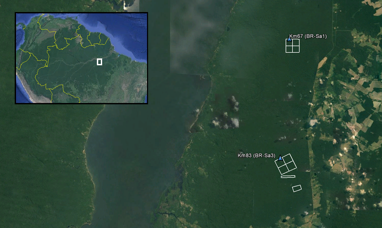
Figure 1. Footprints from each of the surveyed areas within Tapajos National Forest in Para, Brazil are included in TAP_A_footprints.shp. The Km67 and Km83 eddy flux towers (AmeriFlux Sites BR-Sa1 and BR-Sa3) are within the surveyed areas.
Citation
Lefsky, M.A., S.R. Saleska, and Y.E. Shimabukuro. 2017. LiDAR and DTM Data from Tapajos National Forest in Para, Brazil, 2008. ORNL DAAC, Oak Ridge, Tennessee, USA. https://doi.org/10.3334/ORNLDAAC/1514
Table of Contents
- Dataset Overview
- Data Characteristics
- Application and Derivation
- Quality Assessment
- Data Acquisition, Materials, and Methods
- Data Access
- References
Dataset Overview
This data set provides LiDAR point clouds and digital terrain models (DTM) from surveys over the Tapajos National Forest in Belterra municipality, Para, Brazil during late June and early July 2008. The surveys encompass two eddy flux towers managed through the Large-Scale Biosphere-Atmosphere Experiment in Amazonia providing long-term flux measurements of carbon dioxide. The LiDAR data was collected to measure forest canopy structure across Amazonian landscapes to monitor the effects of selective logging on forest biomass and carbon balance, and forest recovery over time.
Related Data Sets:
Keller, M.M., and M.W. Palace. 2009. LBA-ECO TG-07 Ground-based Biometry Data at km 83 Site, Tapajos National Forest: 1997. ORNL DAAC, Oak Ridge, Tennessee, USA. https://doi.org/10.3334/ORNLDAAC/923
Keller, M.M., R.K. Varner, J.D. Dias, H.S. Silva, P.M. Crill, R.C. JR. de Oliveira, and G.P. Asner. 2009. LBA-ECO TG-07 Trace Gas Fluxes, Undisturbed and Logged Sites, Para, Brazil: 2000-2002. ORNL DAAC, Oak Ridge, Tennessee, USA. https://doi.org/10.3334/ORNLDAAC/926
Varner, R.K., and M.M. Keller. 2009. LBA-ECO TG-07 Soil CO2 Flux by Automated Chamber, Para, Brazil: 2001-2003. ORNL DAAC, Oak Ridge, Tennessee, USA. https://doi.org/10.3334/ORNLDAAC/927
Czikowsky, M.J. 2009. LBA-ECO CD-03 Cloud Base-Backscatter Data, km 67 Tower Site, Tapajos National Forest. ORNL DAAC, Oak Ridge, Tennessee, USA. https://doi.org/10.3334/ORNLDAAC/942
Goulden, M.L., S.D. Miller, and H.R. da Rocha. 2010. LBA-ECO CD-04 Soil Moisture Data, km 83 Tower Site, Tapajos National Forest, Brazil. ORNL DAAC, Oak Ridge, Tennessee, USA. https://doi.org/10.3334/ORNLDAAC/979
Menton, M.C., A.M.S. Figueira, C.A.D. de Sousa, S.D. Miller, H.R. da Rocha, and M.L. Goulden. 2011. LBA-ECO CD-04 Biomass Survey, km 83 Tower Site, Tapajos National Forest, Brazil. ORNL DAAC, Oak Ridge, Tennessee, USA. https://doi.org/10.3334/ORNLDAAC/990
Figueira, A.M.S., C.A.D. de Sousa, M.C. Menton, R.N. Juarez, H.R. da Rocha, S.D. Miller, and M.L. Goulden. 2011. LBA-ECO CD-04 Leaf Litter Data, km 83 Tower Site, Tapajos National Forest, Brazil. ORNL DAAC, Oak Ridge, Tennessee, USA. https://doi.org/10.3334/ORNLDAAC/991
Figueira, A.M.S., C.A.D. de Sousa, M.C. Menton, R.N. Juarez, H.R. da Rocha, S.D. Miller, and M.L. Goulden. 2011. LBA-ECO CD-04 Leaf Area Index, km 83 Tower Site, Tapajos National Forest, Brazil. ORNL DAAC, Oak Ridge, Tennessee, USA. https://doi.org/10.3334/ORNLDAAC/992
Varner, R.K., and M.M. Keller. 2011. LBA-ECO TG-07 Soil Trace Gas Fluxes km 67 Seca-Floresta Site, Tapajos National Forest. ORNL DAAC, Oak Ridge, Tennessee, USA. https://doi.org/10.3334/ORNLDAAC/1026
dos-Santos, M.N., and M.M. Keller. 2016. CMS: LiDAR Data for Forested Areas in Paragominas, Para, Brazil, 2012-2014. ORNL DAAC, Oak Ridge, Tennessee, USA. https://doi.org/10.3334/ORNLDAAC/1302
Lefsky, M.A., S.R. Saleska, and Y.E. Shimabukuro. 2017. LiDAR and DTM Data from Forested Land Near Manaus, Amazonas, Brazil 2008. ORNL DAAC, Oak Ridge, Tennessee, USA. https://doi.org/10.3334/ORNLDAAC/1515
Acknowledgements:
The survey campaigns were funded through grants from NASA (#NNX09AI33G; M. Lefsky et al.) and the NSF (#0721140; S. Saleska, G.G. Parker, Y. Shimabukuro et al.).
Data Characteristics
Spatial Coverage: Tapajós National Forest, Para, Brazil
Spatial Resolution: LiDAR: ~ 10 points per m2 ; DTMs: 1-m
Temporal Coverage: 20080625 - 20080703
Temporal Resolution: One-time flights
Study Area: (all latitude and longitudes given in decimal degrees)
| Site | Westernmost Longitude | Easternmost Longitude | Northernmost Latitude | Southernmost Latitude |
|---|---|---|---|---|
| Tapajós National Forest, Para, Brazil | -54.978 | -54.941 | -2.848 | -3.055 |
Data File Information
There are 10 LiDAR point cloud (*.laz) files and 4 digital terrain models (DTM; *.tif) included in this data set. The survey footprints are provided as an ESRI Shapefile (4 files in TAP_A_footprints.zip) with the footprint of each LAZ file as a feature record identified by the "FILE" attribute. The spatial reference properties for the data files are listed below and additional metadata for each of the survey areas is provided in Table 1.
The shapefile is also provided as a companion file in KMZ (*.kmz) format for viewing in Google Earth.
Spatial Reference Properties
WGS_1984_UTM_zone_21S
WKID: 32721 Authority: EPSG
Projection: Transverse_Mercator
false_easting: 500000.0
false_northing: 10000000.0
central_meridian: -57.0
scale_factor: 0.9996
latitude_of_origin: 0.0
Linear Unit: Meter (1.0)
Geographic Coordinate System: GCS_WGS_1984
Angular Unit: Degree (0.0174532925199433)
Prime Meridian: Greenwich (0.0)
Datum: D_WGS_1984
Spheroid: WGS_1984
Semimajor Axis: 6378137.0
Semiminor Axis: 6356752.314245179
Inverse Flattening: 298.257223563
Table 1. Metadata for LiDAR survey areas
| Survey Area | Date(s) | Number of tiles | Total area (ha) | Avg. point density (ppm2) | Avg. first return density (ppm2) | Avg. flight altitude (m) |
|---|---|---|---|---|---|---|
| TAP_A01 | 20080625, 20080626, 20080627, 20080628, 20080703 | 4 | 400 | 51.71 | 40.6 | 799 |
| TAP_A04 | 20080625, 20080703 | 4 | 579.66 | 14.24 | 11 | 732 |
| TAP_A05 | 20080625 | 1 | 53.14 | 13.04 | 10.41 | 725 |
| TAP_A06 | 20080625 | 1 | 86.82 | 10.64 | 8.52 | 726 |
Application and Derivation
The LiDAR data was collected to measure forest canopy structure across Amazonian landscapes to monitor the effects of selective logging on forest biomass and carbon balance and forest recovery over time (Stark et al., 2012).
Quality Assessment
Checks for horizontal and vertical accuracy, and other standard quality control measures were performed by dataset vendors. Refer to http://mapas.cnpm.embrapa.br/paisagenssustentaveis/ for vendor information.
Data Acquisition, Materials, and Methods
Site
Tapajós National Forest (TNF), located in Para, Brazil, is in the Amazon biome and averages 1,820 mm of precipitation annually with temperatures ranging from 21 to 31 °C and averaging 26 °C. Forest coverage includes dense rainforest with emergent trees, alluvial rainforest flooded for part of the year, open tropical rainforest with palms and vines, and secondary forest along the borders and access routes. TNF was created in 1974 to promote sustainable use of forest resources and scientific research, with emphasis on methods for sustainable exploitation of native forests.
The surveys were flown over the Km67 (Ameriflux, BR-Sa1) and Km83 (Ameriflux, BR-Sa3) eddy flux tower sites, and over a nearby deforestation chronosequence, managed through the LBA project. The towers provide long-term flux measurements of carbon dioxide (Hutyra et al., 2007; Wu et al., 2017). The Km67 site is located on a flat plateau with mature forest cover and has been operational since 2002 aside from an outage in 2006-2008. The Km83 site is located in a logged area of forest and was operational from 2000 to 2004 (Miller et al., 2011).
Please visit the AmeriFlux website for additional information and access to the eddy flux tower data (http://ameriflux.lbl.gov/).
Data Acquisition
LiDAR surveys were flown over the survey sites in June and July 2008 with a Leica ALS-50 instrument LiDAR (Heerbrugg, Switzerland) funded by grants from NASA (#NNX09AI33G to M. Lefsky et al.) and NSF (#0721140 to S. Saleska, G.G. Parker, Y. Shimabukuro et al.). The data were collected and processed to point cloud and DTM files by commercial vendors under these grants, and incorporated into the broader integrated effort of the Sustainable Landscapes project. Sustainable Landscapes is supported by the United States Agency for International Development (USAID) and US Department of State. LiDAR surveys performed through the Sustainable Landscapes project were commissioned by the United States Forest Service in collaboration with the Brazilian Enterprise for Agricultural Research (EMBRAPA).
Data Access
These data are available through the Oak Ridge National Laboratory (ORNL) Distributed Active Archive Center (DAAC).
LiDAR and DTM Data from Tapajos National Forest in Para, Brazil, 2008
Contact for Data Center Access Information:
- E-mail: uso@daac.ornl.gov
- Telephone: +1 (865) 241-3952
References
Hunter, M.O., M. Keller, D. Morton, B. Cook, M. Lefsky, and M. Ducey et al. (2015) Structural Dynamics of Tropical Moist Forest Gaps. PLoS ONE10(7): e0132144. https://doi.org/10.1371/journal.pone.0132144
Hutyra, L.R., J.W. Munger, S.R. Saleska, E. Gottlieb, B.C. Daube, A.L. Dunn, D.F. Amaral, P.B. de Camargo, and S.C. Wofsy. 2007. Seasonal controls on the exchange of carbon and water in an Amazonian rain forest: SEASONALITY OF AMAZONIAN CARBON FLUXES. J. Geophys. Res. Biogeosciences 112. https://doi.org/10.1029/2006JG000365
Miller, S.D., M.L. Goulden, L.R. Hutyra, M. Keller, S.R. Saleska, S.C. Wofsy, A.M.S. Figueira, H.R. da Rocha, and P.B. de Camargo. 2011. Reduced impact logging minimally alters tropical rainforest carbon and energy exchange. PNAS vol. 108, no. 48 19431-19435. https://doi.org/10.1073/pnas.1105068108
Stark, S.C., V. Leitold, J. L. Wu, M.O. Hunter, C.V. de Castilho, F.R.C. Costa, S.M. McMahon, G.G. Parker, M.T. Shimabukuro, M.A. Lefsky, M. Keller, L.F. Alves, J. Schietti, Y.E. Shimabukuro, D.O. Brandão, T.K. Woodcock, N. Higuchi, P.B. de Camargo, R.C. de Oliveira, and S.R. Saleska. 2012. Amazon forest carbon dynamics predicted by profiles of canopy leaf area and light environment. Ecology Letters 15: 1406-1414. https://doi.org/10.1111/j.1461-0248.2012.01864.x
Stark, S.C., B.J. Enquist, S.R. Saleska, V. Leitold, J. Schlietti, M. Longo, L.F. Alves, P.B. Camargo, and R.C. Oliveira. 2015. Linking canopy leaf area and light environments with tree size distributions to explain Amazon forest demography. Ecology Letters. https://doi.org/10.1111/ele.12440
Wu, J., K. Guan, M. Hayek, N. Restrepo-Coupe, K.T. Wiedemann, X. Xu, R. Wehr, B.O. Christoffersen, G. Miao, R. da Silva, A.C. de Araujo, R.C. Oliviera, P.B. Camargo, R.K. Monson, A.R. Huete, and S.R. Saleska. 2017. Partitioning controls on Amazon forest photosynthesis between environmental and biotic factors at hourly to interannual timescales. Glob. Change Biol. 23, 1240–1257. https://doi.org/10.1111/gcb.13509