Get Data
Summary:
This data set reports the results of the analysis of soil samples for nitrate (NO3) and physical properties that were collected for one year following reduced impact logging in logging concessions at the Fazenda Rohsamar in the municipality of Juruena in northwestern Mato Grosso. Sample locations were randomly selected from stratified regions of the 1,400 ha Block 5 to account for local scale soil variability. Soil samples were collected to 8-m depth in (1) nine gaps formed by single tree removal and (2) nine areas of undisturbed primary forest. Areas of undisturbed forest were confined to patches of forest within Block 5 that were protected from logging. An additional 3 forested areas were sampled to 3-m depth that contained high sand content. These results quantified the effects of reduced impact logging, to test whether nitrogen (N) loss from leaves and coarse woody debris under reduced impact logging results in a significant accumulation of subsoil nitrate (Feldpausch et al., 2009). One comma separated data file contains the soil moisture results and a second file the soil NO3 content and soil physical properties.
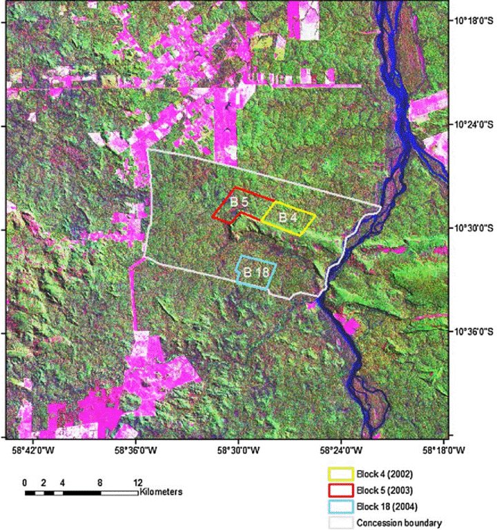
Figure 1. LANDSAT TM image (acquired July 1996) showing the location of the logging concession at Fazenda Rosahmar adjacent to the Rio Juruena in the county of Juruena in southern Amazonia, MT, Brazil. Boundaries are shown for Blocks 4, 5, and 18. Pink areas inside the concession indicate low-stature vegetation. Pink areas outside the concession are deforested and are most frequently pastures. Aqua blue areas indicate low-lying areas or water. Green areas are native forest vegetation. From Feldpausch et al., 2006.
Data Citation:
Cite this data set as follows:
Feldpausch, T.R., E.G. Couto, J. Lehmann, S.J. Riha. 2010. LBA-ECO ND-11 Forest Soil Structure and Nitrate, NW Mato Grosso, Brazil: 2004-2005. Data set. Available on-line [http://daac.ornl.gov] from Oak Ridge National Laboratory Distributed Active Archive Center, Oak Ridge, Tennessee, U.S.A. doi:10.3334/ORNLDAAC/976
Implementation of the LBA Data and Publication Policy by Data Users:
The LBA Data and Publication Policy [http://daac.ornl.gov/LBA/lba_data_policy.html] is in effect for a period of five (5) years from the date of archiving and should be followed by data users who have obtained LBA data sets from the ORNL DAAC. Users who download LBA data in the five years after data have been archived must contact the investigators who collected the data, per provisions 6 and 7 in the Policy.
This data set was archived in May of 2010. Users who download the data between May 2010 and April 2015 must comply with the LBA Data and Publication Policy.
Data users should use the Investigator contact information in this document to communicate with the data provider. Alternatively, the LBA Web Site [http://lba.inpa.gov.br/lba/] in Brazil will have current contact information.
Data users should use the Data Set Citation and other applicable references provided in this document to acknowledge use of the data.
Table of Contents:
- 1 Data Set Overview
- 2 Data Characteristics
- 3 Applications and Derivation
- 4 Quality Assessment
- 5 Acquisition Materials and Methods
- 6 Data Access
- 7 References
1. Data Set Overview:
Project: LBA (Large-Scale Biosphere-Atmosphere Experiment in the Amazon)
Activity: LBA-ECO
LBA Science Component: Nutrient Dynamics
Team ID: ND-11 (Lehmann / Passos / Couto)
The investigators were Feldpausch, Ted R.; Riha, Susan J.; Passos, Carlos Alberto M.; Lehmann, Johannes; Couto, Eduardo Guimaraes ; Pauletto, Daniela; Rodrigues, Luiz Carlos and Johnson, Mark. You may contact Feldpausch, Ted R. (t.r.feldpausch@leeds.ac.uk ) and Luiz Carlos Rodrigues (mattosr@cpd.ufmt.br).
LBA Data Set Inventory ID: ND11_Soil_Nitrate_Moisture_MT
This data set reports the results of the analysis of soil samples for NO3 and physical properties that were collected for one year following reduced impact logging in logging concessions at the Fazenda Rohsamar in the municipality of Juruena in northwestern Mato Grosso. These results quantified the effects of reduced impact logging, to test whether N loss from leaves and coarse woody debris under reduced impact logging results in a significant accumulation of subsoil nitrate (Feldpausch et al., 2009). One comma separated data file contains the soil moisture results and a second file the soil NO3 content and soil physical properties. Data are final and no further modifications are anticipated.
Related Data Sets
- LBA-ECO ND-11 Forest Damage following Reduced Impact Logging, NW Mato Grosso, Brazil (Related data from the same treatment areas )
- LBA-ECO ND-11 Pre-harvest Forest Tree and Liana Biomass, NW Mato Grosso, Brazil: 2003 (Data from the same area collected prior to reduced impact logging treatment)
2. Data Characteristics:
All data were collected in the municipality of Juruena in the state of Mato Grosso. Samples were collected between Aug 2004 and August 2005. Two comma-delimited ASCII files are provided.
File #1:
ND11_Soil_Moisture_NO3_Study_MT.csv
This file provides measurements of soil moisture in gaps and
undisturbed primary forest in Mato Grosso, Brazil.
| Column | Heading | Units/Format | Description |
|---|---|---|---|
| 1 | Date | YYYYMMDD | Date sampled |
| 2 | Month | mon | Month sampled |
| 3 | Year | YYYY | Year sampled |
| 4 | Replicate | Replicate a or b at the same sampling depth | |
| 5 | Sub_block | Sub-block (UT), work unit within the logging block (e.g., Basin-1, Basin-4, UT-8) | |
| 6 | Tube | Tube number | |
| 7 | Canopy | Intact or gap | |
| 8 | Depth_class | Four depth classes (cm): 0 to 50, >50 to 100, >100 to 150, >150 to 180 | |
| 9 | Sampling_depth | cm | Sampling depth |
| 10 | Soil _moisture | % | Determined by drying soil samples for 48 hours at 105 degrees C. |
| Missing data are indicated with -9999. | |||
| All sampling took place in Logging Block 5. | |||
Example Data Records:
| Header records omitted Date,Month,Year,Replicate,Sub_block,Tube,Canopy,Depth_class,Sampling_depth,Soil _moisture 20040813,Aug.,2004,a,Basin-1,T6,Intact,0 to 50,10,20.5 20040813,Aug.,2004,a,Basin-1,T6,Intact,0 to 50,20,21.1 20040813,Aug.,2004,a,Basin-1,T6,Intact,0 to 50,40,22.5 ... 20050818,Aug.,2005,b,UT-8,T29,Gap,0 to 50,10,15.4 20050818,Aug.,2005,b,UT-8,T29,Gap,0 to 50,20,18.5 20050818,Aug.,2005,b,UT-8,T29,Gap,0 to 50,40,22.1 |
File #2: ND11_Soil_Texture_NO3_Study_MT.csv
This file provides measurements of soil nitrate, soil texture and bulk
density in gaps and undisturbed primary forest in Mato Grosso, Brazil.
| Column | Heading | Units / Format | Description |
|---|---|---|---|
| 1 | Date | YYYYMMDD | Date sampled |
| 2 | Sub_block | Sub-block (UT), work unit within the logging block (e.g., Basin-1, Basin-4, UT-8) | |
| 3 | Gap_number | Project gap designation | |
| 4 | Sample_number | Project sample number | |
| 5 | Site_type | Site type, Logged gap or Forest | |
| 6 | Sampling_depth | cm | Sampling depth range (e.g., 0-20, 200-250) |
| 7 | NO3_solution | ug/L | NO3 concentration of soil extraction |
| 8 | NO3_soil | mg/kg | NO3 concentration in soil. Soil NO3 was calculated by converting solution content to adjusted volume based on soil water content and soil bulk density. |
| 9 | Clay | % | Percent clay |
| 10 | Silt | % | Percent silt |
| 11 | Sand | % | Percent sand |
| 12 | Soil_bulk_density | g soil/cm3 | Soil bulk density |
| Missing data are indicated with -9999. | |||
| All sampling took place in Logging Block 5. | |||
Example Data Records:
| Header records omitted Date,Sub_block,Gap_number,Sample_number,Site_type,Sampling_depth,NO3_solution,NO3_soil,Clay,Silt,Sand,Soil_bulk_density 20041005,4,21,1,Logged gap,0-20,297.48,0.957,6.2,11.22,82.58,1.21 20041005,4,21,2,Logged gap,20-40,111.03,0.26,11.18,6.24,82.58,1.25 20041005,4,21,3,Logged gap,40-60,159.75,0.439,16.2,9.56,74.24,1.22 ... 20040803,Basin-2,B2F9,133,Forest,200-250,168.11,-9999,-9999,-9999,-9999,1.2 20040803,Basin-2,B2F9,134,Forest,250-300,85.677,-9999,-9999,-9999,-9999,1.27 20040803,Basin-2,B2F9,135,Forest,300-350,34.035,-9999,-9999,-9999,-9999,1.08 |
Site boundaries: (All latitude and longitude given in degrees and fractions)
| Site (Region) | Westernmost Longitude | Easternmost Longitude | Northernmost Latitude | Southernmost Latitude | Geodetic Datum |
|---|---|---|---|---|---|
| Mato Grosso - Juruena (Mato Grosso) | -58.75969 | -58.75969 | -10.42492 | -10.42492 | World Geodetic System, 1984 (WGS-84) |
Time period:
- The data set covers the period 2004/08/03 to 2005/08/18.
- Temporal Resolution: Samples for soil NO3 and soil physical properties were collected in August and October, 2004. Soil moisture samples were collected 10 times from August 2004 to August 2005.
Platform/Sensor/Parameters measured include:
- LABORATORY / WEIGHING BALANCE / SOIL MOISTURE/WATER CONTENT
- LABORATORY / SPECTROPHOTOMETER / NITROGEN
- LABORATORY / WEIGHING BALANCE / SOIL BULK DENSITY
- LABORATORY / HUMAN OBSERVER / SOIL TEXTURE
3. Data Application and Derivation:
These data can be applied to model the effects of reduced impact logging on nitrogen cycling with potential implications for forest recovery and carbon sequestration in undisturbed and logged forests.
4. Quality Assessment:
At this time there are no known problems with the data.
5. Data Acquisition Materials and Methods:
Soil samples for NO3 analysis and soil physical properties were taken one year following reduced impact logging using a stratified random soil sampling scheme (sample locations were randomly selected from stratified regions of the block to account for local scale soil variability). From these randomly selected areas we collected soil samples to 8-m depth in 9 gaps formed by single tree removal and 9 areas of undisturbed primary forest. An additional 3 forested areas were sampled to 3-m depth that contained high sand content. Soil samples were collected from below the prone crown of the logged tree within each gap or within undisturbed forest using an Edelman auger extendable to 8-m at the following depth increments: 0-20, 20-40, 40-60, 60-100, and 50 cm increments thereafter. Soil samples were stored in bags in a cooler with ice in the field and stored at 2 degrees C at the end of the day (Feldpausch et al., 2009).
Soil mineral N was extracted the following day with 1N Potassium Chloride (KCL). The soil and KCl solution was shaken for 5 minutes and then stored at 2 degrees C for 16 hours to allow the soil to settle. Subsequently, 60 ml of the supernatant was transferred to new vials and stored at 2 degrees C until analyzed. The samples were filtered and analyzed by cadmium reduction.
Nitrate (NO3) was measured on a spectrophotometer (GENESYS 5) at the Universidade Federal de Mato Grosso, Cuiaba. Soil nitrate was calculated by converting solution content to adjusted volume based on soil water content and soil bulk density measured to 8-m depth.
Soil physical properties were measured in the intact 8-m deep forest samples. The soil was air dried, screened through a 2 mm stainless-steel sieve and analyzed according to methods described by EMBRAPA (Silva, 1999). Soil bulk density was measured at the depth increments given above to 8-m depth by collecting a known soil sample volume using an Edelman auger.
Soil moisture samples were collected 10 times from August 2004 to August 2005. To determine soil water content, 40-50 g of soil was taken from the sample, weighed wet, dried for 48 hours at 105 degrees C to constant weight and re-weighed.
6. Data Access:
This data is available through the Oak Ridge National Laboratory (ORNL) Distributed Active Archive Center (DAAC).
Data Archive Center:
Contact for Data Center Access Information:
E-mail: uso@daac.ornl.gov
Telephone: +1 (865) 241-3952
7. References:
Feldpausch, T.R., A.J. McDonald, C.A.M. Passos, J. Lehmann, and S.J. Riha. 2006. Biomass, harvestable area, and forest structure estimated from commercial timber inventories and remotely sensed imagery in southern Amazonia. Forest Ecology and Management 233(1):121-132. doi:10.1016/j.foreco.2006.06.016
Feldpausch, Ted R., Eduardo G. Couto, Luiz Carlos Rodrigues, Daniela Pauletto, Mark S. Johnson, Timothy J. Fahey, Johannes Lehmann, and Susan J. Riha. 2009. Nitrogen aboveground turnover and soil stocks to 8-m depth in primary and selectively logged forest in southern Amazonia. Global Change Biology. doi: 10.1111/j.1365-2486.2009.02068.x
Silva.F.C. d. 1999. A manual of chemical analyses for
soils, plants and fertilizers. EMBRAPA Technology Transfer
Communication, Brasilia DF.