Get Data
Summary:
Data were collected in the logging concession at the Fazenda Rohsamar in the municipality of Juruena in northwestern Mato Grosso. Estimates of damage associated with logging operations were made after logging operations were complete in 2003 and 2004. Damage associated with gaps created by felling single trees was estimated in 54 individual gaps. Characteristics of the single harvested tree were recorded and included species, DBH, commercial height, total height, and canopy proportions. Damage to all surrounding trees was recorded. Stratified transects in two logging blocks were used to estimate damage associated with road building and skid trails. Twenty-six transects were established in Block 5 and 21 transects in Block 18 to assess the frequency of damage by log skidders and tree felling. The boundaries between different types of damage were noted along the transect and the length in meters of that damage type along the transect was recorded. From this information, the area of the logging block affected by tree felling, road building, and skid trails was estimated.
The Gap Survey and the Logging Damage Transects Survey data are provided in comma-separated ASCII files. A third file provides the coordinates of the starting points for the Survey Transects.
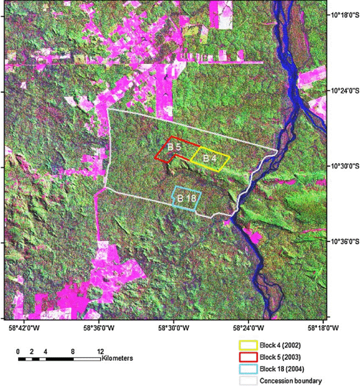
Figure 1. LANDSAT TM image (acquired July 1996) showing the location of the logging concession at Fazenda Rosahmar adjacent to the Rio Juruena in the county of Juruena in southern Amazonia, MT, Brazil. Boundaries are shown for Blocks 4, 5, and 18. Pink areas inside the concession indicate low-stature vegetation. Pink areas outside the concession are deforested and are most frequently pastures. Aqua blue areas indicate low-lying areas or water. Green areas are native forest vegetation. From Feldpausch et al., 2006.
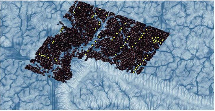
Figure 2. Commercial timber inventory (dark points) and scientific transect waypoints (yellow points) for Block 5, super-imposed on the topographic index (derived from 30-m ASTER DEM; identifies areas of landscape with similar hydrology. Darker tones represent convergence zones, whereas the lighter areas are well drained.
Data Citation:
Cite this data set as follows:
Feldpausch, T.R., S. Jirka, C.A.M. Passos, and S.J. Riha. 2010. LBA-ECO ND-11 Forest Damage following Reduced Impact Logging, NW Mato Grosso, Brazil. Data set. Available on-line [http://daac.ornl.gov] from Oak Ridge National Laboratory Distributed Active Archive Center, Oak Ridge, Tennessee, U.S.A. doi:10.3334/ORNLDAAC/977
Implementation of the LBA Data and Publication Policy by Data Users:
The LBA Data and Publication Policy [http://daac.ornl.gov/LBA/lba_data_policy.html] is in effect for a period of five (5) years from the date of archiving and should be followed by data users who have obtained LBA data sets from the ORNL DAAC. Users who download LBA data in the five years after data have been archived must contact the investigators who collected the data, per provisions 6 and 7 in the Policy.
This data set was archived in May of 2010. Users who download the data between May 2010 and April 2015 must comply with the LBA Data and Publication Policy.
Data users should use the Investigator contact information in this document to communicate with the data provider. Alternatively, the LBA Web Site [http://lba.inpa.gov.br/lba/] in Brazil will have current contact information.
Data users should use the Data Set Citation and other applicable references provided in this document to acknowledge use of the data.
Table of Contents:
- 1 Data Set Overview
- 2 Data Characteristics
- 3 Applications and Derivation
- 4 Quality Assessment
- 5 Acquisition Materials and Methods
- 6 Data Access
- 7 References
1. Data Set Overview:
Project: LBA (Large-Scale Biosphere-Atmosphere Experiment in the Amazon)
Activity: LBA-ECO
LBA Science Component: Nutrient Dynamics
Team ID: ND-11 (Lehmann / Passos / Couto)
The investigators were Feldpausch, Ted R.; Jirka, Stefan; Riha, Susan J.; Passos, Carlos Alberto M.; Lehmann, Johannes; Noquelli, Maria Jose Miranda de Souza; Pauletto, Daniela; Gandini, Elenara and Fernandes, Erick C.M. . You may contact Ted Feldpausch (t.r.feldpausch@leeds.ac.uk)
LBA Data Set Inventory ID: ND11_Logging_Damage_MT
These data were collected in the logging concession at the Fazenda Rohsamar in the municipality of Juruena in northwestern Mato Grosso. Estimates of damage associated with logging operations were made after logging operations were complete in 2003 and 2004. Damage associated with gaps created by felling single trees was estimated in 54 individual gaps. Characteristics of the single harvested tree were recorded and included species, DBH, commercial height, total height, and canopy proportions. Damage to all surrounding trees was recorded. Stratified transects in two logging blocks were used to estimate damage associated with road building and skid trails. Twenty-six transects were established in Block 5 and 21 transects in Block 18 to assess the frequency of damage by log skidders and tree felling. The boundaries between different types of damage were noted along the transect and the length in meters of that damage type along the transect was recorded. From this information, the area of the logging block affected by tree felling, road building, and skid trails was estimated.
Related Data Set:
- LBA-ECO ND-11 Forest Soil Structure and Nitrate, NW Mato Grosso, Brazil: 2004-2005 (Conducted at the same location)
- LBA-ECO ND-11 Regeneration in Undisturbed and Logged Forests, NW Mato Grosso, Brazil (Conducted at the same location, both examine the effect of RIL management)
2. Data Characteristics:
Data were collected in logging concession at
the Fazenda
Rohsamar in the municipality of Juruena in northwestern Mato Grosso.
Estimates of damage associated with logging operations were made after
logging operations were complete in 2003 and 2004. Damage associated
with gaps created by felling single trees was estimated in 54
individual gaps. Stratified transects in two logging blocks were used
to estimate damage associated with road building and skid trails.
Three comma-delimited ASCII files are provided.
File #1: ND11_Logging_Damage_Gap_Survey_MT.csv
| Column | Column Heading | Units | Description |
|---|---|---|---|
| 1 | YYYY/MM/DD | Survey date | |
| 2 | Year_logged | YYYY | Year logged |
| 3 | Block | Logging block ID | |
| 4 | Transect | Transect number - Rohden Industria timber survey transects | |
| 5 | Tree_number | Unique id - tree ID number based on Rohden Industria tree numbering system | |
| 6 | Common_name | Tree common name | |
| 7 | Fall_bearing | degrees from true North | Direction of tree fall |
| 8 | Total_gap_area | m2 | Gap area was measured using the center point system (Runkle 1982) based on the summation of the area of six triangles using the distance from the center of the gap to the edge to define the triangles. |
| 9 | DBH_Rohden | m | DBH - Rohden Industria timber survey |
| 10 | Volume_Rohden | m3 | Volume bole - Rohden Industria timber survey |
| 11 | Commercial_bole | m | Length to first bifurcation |
| 12 | Crown_height | m | Distance from first bifurcation to top of crown |
| 13 | Total_tree_height | m | Total tree height calculated as Commercial_bole + Crown_height |
| 14 | Crown_width | m | Crown width |
| 15 | Crown_area | m2 | Crown area |
| 16 | Crown_volume | m3 | Crown volume calculated as vol=4/3*PI*Crown_height*Crown_width^2 |
| 17 | Stump_sawn_height | cm | Stump sawn height |
| 18 | Total_stems_damaged_gap | Damaged stems were those still standing above 1.3 m height | |
| 19 | Stems_severed_smashed_gap | Severed or smashed stems were severed below 1.3 m height or had been crushed prone |
Example Data Records:
| Sample_date,Year_logged,Block,Transect,Tree_number,Common_name,Fall_bearing,Total_gap_area,DBH_Rohden,Volume_Rohden,Commercial_bole, Crown_height,Total_tree_height,Crown_width,Crown_area,Crown_volume,Stump_sawn_height,Total_stems_damaged_gap,Stems_severed_smashed_gap 2004/08/25,2004,1,1,21,Cedro marinheiro,292,328.6,0.76,8.02,17.2,17.3,34.5,18.8,1021.8,25612,40,30,16 2004/08/25,2004,1,11,24,Angelim amargo,72,251.6,1.18,30.5,24.5,22.4,46.9,9.4,661.5,8291,35,17,6 2004/08/25,2004,1,2,387,Caixeta/Marupa,340,136.7,0.81,6.83,14.9,15.6,30.5,19.3,945.9,24340,26,20,8 ... 2003/10/08,2003,5,17,15091,Ipe amarelo,358,159.8,0.64,2.9,16.6,22.8,39.4,15.7,1124.6,23541,62,19,3 2003/10/07,2003,8,15,15125,Caixeta/Marupa,320,167.6,0.64,2.67,19.5,9.6,29.1,16.8,506.7,11350,46,22,10 2003/10/07,2003,5,19,16053,Angelim amargo,48,86.6,0.64,4.46,26.6,12.5,39.1,9,353.4,4241,33,10,3 |
file # 2:
ND11_Logging_Damage_Transects_Survey_MT.csv
| Column | Column Heading | Units | Description |
|---|---|---|---|
| 1 | Sample_date | YYYY/MM/DD | Sample date. |
| 2 | Block | Logging block ID | |
| 3 | Sub_block | Work unit id (some ?) | |
| 4 | Transect | Transect ID | |
| 5 | Transect_total | meters | Total length of transect. Value repeated for each Damage observation on that Transect. |
| 6 | Forest_type | Forest type description | |
| 7 | Landscape_position | Transect sections (25 m) were assigned to one of three topographic positions (upland, lowland, or slope) based on estimates of hardwood (upland) vs. palms (lowland), slope, and proximity to streams. | |
| 8 | Damage_class | Category of ground damage: gap, none, road, or skid. | |
| 9 | Ground_damage_length | meters |
Distance
in meters of damage class along the Transect. Distances are
consecutive from the origin of the Transect and sum to the Transect_total length. |
| 10 | Canopy_damage_length | meters | Distance
in meters (linear) along a Transect that canopy damage occurred. Canopy
damage is always related to an area of ground damage. Zeros represent zero canopy damage within Damage_class. |
Example Data Records:
| Sample_date,Block,Sub_block,Transect,Transect_total,Forest_type,Landscape_position,Damage,Ground_damage_intercept,Canopy_damage_intercept 2004/09/22,5,1,Picada22,646.9,Dominant,upland,none,32.8,0 2004/09/22,5,1,Picada22,646.9,Dominant,upland,gap,16.2,16.2 2004/09/22,5,1,Picada22,646.9,Dominant,upland,none,20.5,0 ... 2005/07/06,5,1,Ben-Eli-27,260.1,Dominant,low,none,21.6,0 2005/07/06,5,1,Ben-Eli-27,260.1,Dominant,low,none,21.2,0 2005/07/06,5,1,Ben-Eli-27,260.1,Dominant,low,none,16.7,0 |
File #3: ND11_Logging_Damage_Transects_GPS_MT_2003.csv
| Column | Column Heading | Units | Description |
|---|---|---|---|
| 1 | Block | Logging block ID | |
| 2 | Transect | Transect ID | |
| 3 | X_start | meters | Location of the transect starting point. UTM, Zone 22S |
| 4 | Y_start | meters | Location of the transect starting point. UTM, Zone 22S |
Example Data Records
| Block,Transect,X_start,Y_start 5,Picada22,338560,8841797 5,NP2,338301,8840693 5,NP10a,334631,8840809 5,NP7,335038,8840390 5,NP10b,334273,8840662 ... 18,Ben-Eli-18,338638,8834894 18,Ben-Eli-19,337698,8834846 18,Ben-Eli-20,336858,8834716 18,Ben-Eli-21,337299,8834546 18,Ben-Eli-22,336226,8833296 |
Site boundaries: (All latitude and longitude given in degrees and fractions)
| Site (Region) | Westernmost Longitude | Easternmost Longitude | Northernmost Latitude | Southernmost Latitude | Geodetic Datum |
|---|---|---|---|---|---|
| Mato Grosso - Juruena (Mato Grosso) | -58.75969 | -58.75969 | -10.42492 | -10.42492 | World Geodetic System, 1984 (WGS-84) |
Time period:
- The data set covers the period 2003/09/30 to 2005/07/06.
- Temporal Resolution: Annual
Platform/Sensor/Parameters measured include:
- VEGETATION SURVEY / HUMAN OBSERVER / FOREST COMPOSITION/VEGETATION STRUCTURE
- FIELD SURVEY / HUMAN OBSERVER / CANOPY CHARACTERISTICS
- FIELD SURVEY / STEEL MEASURING TAPE / PLANT CHARACTERISTICS
3. Data Application and Derivation:
The methods developed in this study could be
useful for
facilitating commercial inventory practices, understanding the
relationship of tree species distribution to landscape features, and
improving the novel use of commercial timber inventories to estimate
above ground biomass.
| Damage | Ground damage length(m) | Canopy damage length(m) |
|---|---|---|
| gap | 25.9 | 16.1 |
| none | 91.1 | 0 |
| gap | 7.6 | 9 |
| skid | 4.3 | 0 |
| none | 9.4 | 0 |
| gap | 4.1 | 4.1 |
| none | 119.1 | 0 |
In this example, along a 261.5 m transect, at various point along the transect either ground disturbance or canopy disturbance was noted. For example, after 91.1 m of no ground damage, then 7.6 m of gap ground damage, and within that area of gap ground damage, there was 9 m of canopy opening (linear). The meters of "ground damage"sum to the total transect length of 261.5 m.
4. Quality Assessment:
Care should be taken in using tree taxonomic data since local names were converted to Latin names for species identification.
5. Data Acquisition Materials and Methods:
Logging Damage Transect Survey:
Sampling was
stratified to provide full coverage of each logging block. Within a
stratified area the transect start point was randomly selected.
Twenty-six transects were established in Block 5 and 21 transects in
Block 18 to assess the frequency of damage by log skidders and tree
felling. Distance along the transect for each type of damage was recorded. Transect sections (25 m) were assigned to one of three
topographic positions (upland, lowland, or slope) based on estimates of
hardwood vs. palms, slope, and proximity to streams. Road and deck
locations in Blocks 5 and 18 were mapped with a GPS. Road width was
measured at 11 random points and deck size was measured at 10 decks
(representing 11% of the total). Total length and area in roads were
calculated and maps produced using GIS (Figure 3).
Logging Damage Gap Survey:
Survey of Damage Caused by Single Tree Logging:
To quantify the effects of single logged tree fall, a survey was performed in 54 gaps formed by the felling of single trees. Characteristics of the single harvested tree were recorded and included species, DBH, commercial height, total height, and canopy proportions. Damage to all surrounding trees was recorded. Gap-trees damaged were assigned to one of nine classes based on the severity of damage. Damage to trees in the gaps varied from a slight bump (I) or minor to severe bark loss (II and III), to minor to severe canopy damage (IV–VII), to more acute damage including severing of the trunk (VIII) and crushing the entire tree to the ground (IX). "Total_stems_damaged_gap" report the total number of trees in all nine classes. The field "Stems_severed_smashed_gap" reports trees in classes VIII and IX (Feldpausch et al., 2005). Gaps were defined as the actual projected canopy and gap area was measured using the center point system (Runkle 1982) based on the summation of the area of six triangles using the distance from the center of the gap to the edge to define the triangles.
Of the 1,031 measured damaged trees (>10 cm DBH), nearly 50% either had the trunk severed or were crushed to the ground, which is equivalent to 5 trees severed at the trunk and 5 trees crushed to the ground for every tree logged. Damage in these two classes results in tree mortality in the absence of stump or stem coppicing.
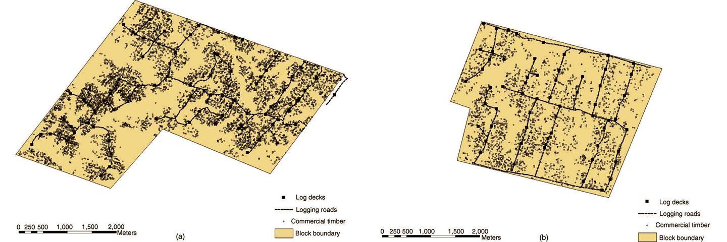
Figure 3. Locations of logging roads, log decks, and commercial timber in Blocks 5 (a) and 18 (b).
6. Data Access:
This data is available through the Oak Ridge National Laboratory (ORNL) Distributed Active Archive Center (DAAC).
Data Archive Center:
Contact for Data Center Access Information:
E-mail: uso@daac.ornl.gov
Telephone: +1 (865) 241-3952
7. References:
Feldpausch, T.R., S. Jirka, C.A.M. Passos, F. Jasper, and S.J. Riha. 2005. When big trees fall: Damage and carbon export by reduced impact logging in southern Amazonia. Forest Ecology and Management 219(2-3):199-215.
Feldpausch, T.R., A.J. McDonald, C.A.M. Passos, J. Lehmann, and S.J. Riha. 2006. Biomass, harvestable area, and forest structure estimated from commercial timber inventories and remotely sensed imagery in southern Amazonia. Forest Ecology and Management 233(1):121-132.doi:10.1016/j.foreco.2006.06.016
Runkle, J.R. 1982. Patterns of disturbance in some old-growth mesic forest of eastern North America. Ecology 63: 1533-1541.
Related Publications
- Feldpausch, T.R., S. Jirka, C.A.M. Passos, F. Jasper, and S.J. Riha. 2005. When big trees fall: Damage and carbon export by reduced impact logging in southern Amazonia. Forest Ecology and Management 219(2-3):199-215.