Get Data
Summary:
This data set contains soil water measurements
to a depth of 3 meters for the years 1999, 2000, and 2001, and total monthly
precipitation data for 1999-2000. The data were collected from a pasture site
located at the Embrapa Pasture Reseach Site, a former cattle research station 54
km north of Manaus on the highway BR 174 Manaus-Boa Vista, Brazil.
There are three comma-separated data files
(.csv) with this data set.
DATA QUALITY STATEMENT: The Data Center has determined that there are questions about the quality of the data reported in this data set. The data set has missing or incomplete data, metadata, or other documentation that diminishes the usability of the products.
KNOWN PROBLEMS: There is no associated research documentation and the units were not provided with the data.
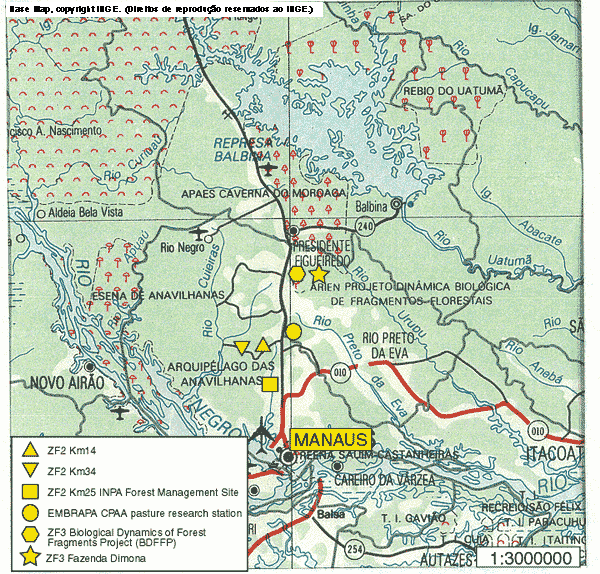
Figure 1. Map of EMBRAPA DAS Experiment - km 54 at the CPAA pasture research station
Data Citation:
Cite this data set as follows:
S.A. Welch. 2014. LBA-ECO ND-04 Pasture Soil Water and Precipitation, Km 54, Manaus, Brazil: 1999-2001. Data set. Available on-line [http://daac.ornl.gov] from Oak Ridge National Laboratory Distributed Active Archive Center, Oak Ridge, Tennessee, USA. http://dx.doi.org/10.3334/ORNLDAAC/1246
Implementation of the LBA Data and Publication Policy by Data Users:
The LBA Data and Publication Policy [http://daac.ornl.gov/LBA/lba_data_policy.html] is in effect for a period of five (5) years from the date of archiving and should be followed by data users who have obtained LBA data sets from the ORNL DAAC. Users who download LBA data in the five years after data have been archived must contact the investigators who collected the data, per provisions 6 and 7 in the Policy.
This data set was archived in September 2014. Users who download the data between September 2014 and August 2019 must comply with the LBA Data and Publication Policy.
Data users should use the Investigator contact information in this document to communicate with the data provider.
Data users should use the Data Set Citation and other applicable references provided in this document to acknowledge use of the data.
Table of Contents:
- 1 Data Set Overview
- 2 Data Characteristics
- 3 Applications and Derivation
- 4 Quality Assessment
- 5 Acquisition Materials and Methods
- 6 Data Access
- 7 References
1. Data Set Overview:
Project: LBA (Large-Scale Biosphere-Atmosphere Experiment in the Amazon)
Activity: LBA-ECO
LBA Science Component: Nutrient Dynamics
Team ID: ND-04 (Fernandes / Wandelli)
The investigators were Fernandes, Erick C.M.; Wandelli, Elisa Vieira, and Stephen Welch.You may contact Welch, S.A. (saw16@cornell.edu).
LBA Data Set Inventory ID: ND04_Soil_H2O_Manaus
This data set contains soil water measurements
to a depth of 3 meters for the years 1999, 2000, and 2001, and total monthly
precipitation data for 1999-2000. The data were collected from a pasture site
located at the Embrapa Pasture Reseach Site, a former cattle research station 54
km north of Manaus on the highway BR 174 Manaus-Boa Vista, Brazil.
2. Data Characteristics:
There are three comma-separated data files with this data set:
1. ND04_Manaus_Pasture_Soil_Water_1999_2001.csv: monthly pasture soil water data (volumetric water content, VWC) for 1999, 2000, and 2001. The units are reported in centimeters cubed (cm3) of water per centimeter cubed (cm3) of soil for the defined ~40 cm measurement layers. The units were inferred by the Data Center.
2. ND04_Manaus_SoilWater_Stocks_1999_2001.csv: As inferred by the Data Center, is monthly pasture soil water data (volumetric water content) for 1 meter soil layers for 1999, 2000, and 2001. The values of VWC for the ~40-cm layers (data file 1) were distributed to respective 10-cm layers and then regrouped/averaged to 1-m intervals. The units are reported in centimeters cubed (cm3) of water per centimeter cubed (cm3) of soil x 1000. The units were inferred by the Data Center.
3. ND04_Precipitation_Manaus_1999_2000.csv: total monthly precipitation data for 1999-2000. The units are in millimeters (mm).
Site boundaries: (All latitude and longitude given in decimal degrees)
| Site (Region) | Westernmost Longitude | Easternmost Longitude | Northernmost Latitude | SSouthernmost Latitude |
|---|---|---|---|---|
| Amazonas, Manaus ( Embrapa DAS Experiment site ) | -60.03000 | -60.03000 | -2.51800 | -2.51800 |
Time period:
- The data set covers the period 1999/01/01 to 2001/12/31.
- Temporal Resolution: Monthly.
Platform/Sensor/Parameters measured include:
- FIELD SURVEY / NEUTRON PROBE / SOIL
- GROUND STATION / RAIN GAUGE / PRECIPITATION AMOUNT
3. Data Application and Derivation:
Not provided.
4. Quality Assessment:
Known Problems: There is no associated research documentation and the units were not provided with the data files.
5. Data Acquisition Materials and Methods:
The data were collected from the Embrapa DAS Experiment site (Embrapa–CPAA pasture research station), located 54 km north of Manaus on the highway BR 174 Manaus-Boa Vista. The elevation is 60 m. The site is characterized by a rolling topography with plateaus and small valleys, and the dominant vegetation at the site is evergreen forest. The soil type is a Xanthic Hapludox. Approximately 200 hectares of a forest were cleared and burned in the 1980s, and Brachiaria humidicola pastures were established. The pasture is located on a plateau. Secondary succession of the pastures began soon after pasture establishment.
Soil water was monitored weekly in a pasture north of Manaus in the Central Amazon region. A Didcott neutron probe was used to measure water content to a depth of 3 meters.
Precipitation data were measured with a rain guage.
6. Data Access:
This data is available through the Oak Ridge National Laboratory (ORNL) Distributed Active Archive Center (DAAC).
Data Archive Center:
Contact for Data Center Access Information:
E-mail: uso@daac.ornl.gov
Telephone: +1 (865) 241-3952
7. References:
None provided.