Get Data
Revision date: October 21, 2011
Summary:
This data set contains ESRI shapefiles of historical roads (basin-wide federal and state roads) in nine Brazilian states for the Legal Amazon: Amazonas, Para, Acre, Rondonia, Roraima, Tocantins, Amapa, Matto Grosso, and Maranhao. There are 48 compressed (*.zip) files for the years 1968, 1975, 1981, 1985, 1987, and 1993 in GCS South American 1969 projection.
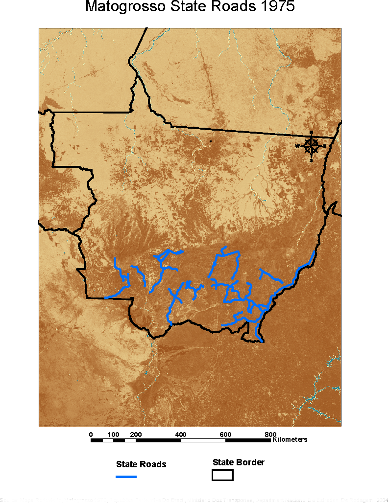
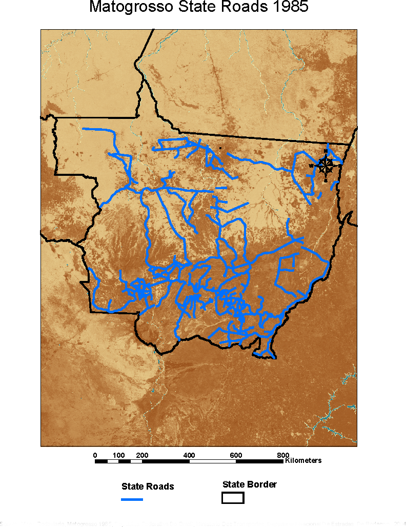
Figure 1. Example images included with this data set: Matto Grosso state roads in 1975 and 1985. Source: Mapa Rodoviario, Matogrosso 1975 and 1985, Republica Federativa Do Brazil, Ministerio Dos Transportes, Department Nacional De Estradas De Rodagem. 2004.
Data Citation:
Cite this data set as follows:
Walker, R.T., E.J. Reis and M.M. Caldas. 2011. LBA-ECO LC-24 Historical Roads of the Legal Amazon: 1968-1993. Data set. Available on-line [http://daac.ornl.gov] from Oak Ridge National Laboratory Distributed Active Archive Center, Oak Ridge, Tennessee, U.S.A. http://dx.doi.org/10.3334/ORNLDAAC/1043
Implementation of the LBA Data and Publication Policy by Data Users:
The LBA Data and Publication Policy [http://daac.ornl.gov/LBA/lba_data_policy.html] is in effect for a period of five (5) years from the date of archiving and should be followed by data users who have obtained LBA data sets from the ORNL DAAC. Users who download LBA data in the five years after data have been archived must contact the investigators who collected the data, per provisions 6 and 7 in the Policy.
This data set was archived in October of 2011. Users who download the data between September 2011 and October 2016 must comply with the LBA Data and Publication Policy.
Data users should use the Investigator contact information in this document to communicate with the data provider. Alternatively, the LBA Web Site [http://lba.inpa.gov.br/lba/] in Brazil will have current contact information.
Data users should use the Data Set Citation and other applicable references provided in this document to acknowledge use of the data.
Table of Contents:
- 1 Data Set Overview
- 2 Data Characteristics
- 3 Applications and Derivation
- 4 Quality Assessment
- 5 Acquisition Materials and Methods
- 6 Data Access
- 7 References
1. Data Set Overview:
Project: LBA (Large-Scale Biosphere-Atmosphere Experiment in the Amazon)
Activity: LBA-ECO
LBA Science Component: Land Use and Land Cover
Team ID: LC-24 (Walker / Reis)
The investigators were Walker, Robert T.; Reis, Eustaquio J; Arima, Eugenio; Bohrer, Claudio Belmonte de Athayde; Caldas, Marcellus Marques; Perz, Stephen G; Pfaff, Alexander; Qi, Jiaguo and Souza Jr., Carlos Moreira de. You may contact Caldas, Marcellus Marques (caldasma@msu.edu).
LBA Data Set Inventory ID: LC24_Historical_Roads_Amazon
This data set contains historical roads for the Legal Amazon in digital format. The data set ranges from 1968 to 1993 for every state in the Legal Amazon.
Related Data Set:
- LBA Regional Boundary for the Legal Amazon of Brazil, 8-km (Same study area)
2. Data Characteristics:
This data set contains ESRI shapefiles of roads for nine states in the Legal Amazon: Amazonas, Para, Acre, Rondonia, Roraima, Tocantins, Amapa, Mato Grosso, and Maranhao, for the years 1968, 1975, 1981, 1985, 1987, and 1993. All years are not included for every state. For example, data for the year 1981 is not included for Tocantins, Rondonia, or Matto Grosso. The files are in GCS South American 1969 projection.
There are 48 compressed (*.zip) files which when extrapolated, contain the shapefiles and a file which contains metadata regarding the originating processing steps of the shapefiles as well as attribute definitions, data quality, spatial reference information, and metadata reference information. The *.zip file names are structured with the state name followed by the year.
Example file names:
acre68_histrds.zip
aamapa68_histrds.zip
amazonas68_histrds.zip
matogrosso68_histrds.zip
maranhao75_histrds.zip
para68_histrds.zip
rondonia68_histrds.zip
tocantins68_histrds.zip
roraima68_histrds.zip
Attribute definitions (also found within each *.zip file):
- FID: Internal feature ID
- Shape: Feature geometry
- ID_: ID for road segment
- Name1_: Highway name as found on digitized paper maps
- Name2_: undefined
- Parts_: Number of parts for segment
- Points_: Number of points for segment
- Length_: Length of segment
- rd_cond: Pavement condition. Codes: 1 = Pavimentada, 2 = Em Pavimentacao, 3 = Implantada, 4 = Em Implantacao, 5 = Leito Natural, 6 = Planejada, 7 = Duplicada, 8 = Em duplicacao
- rd_name: Name of highway segment as found on digitized paper maps
- rd_status: Overseeing authority. Codes: 1 = Federal Control, 2 = State Control
- rd_agree: Whether roads were added to original 1993 data or not Codes: 0 = Road added, 1 = Road not added
Site boundaries: (All latitude and longitude given in decimal degrees)
| Site (Region) | Westernmost Longitude | Easternmost Longitude | Northernmost Latitude | Southernmost Latitude | Geodetic Datum |
|---|---|---|---|---|---|
| Legal Amazon--state boundaries | -75.1879 | -34.04 | 8.3438 | -21.21125 | South-American Datum, 1969 (SAD-69) |
| Acre | -73.802488 | -66.731269 | -7.347822 | -11.022902 | South-American Datum, 1969 (SAD-69) |
| Amapa | -54.742988 | -49.913802 | 4.425561 | -1.092576 | South-American Datum, 1969 (SAD-69) |
| Amazonas | -72.844538 | -56.826486 | 1.536630 | -9.568015 | South-American Datum, 1969 (SAD-69) |
| Maranhao | -47.552983 | -41.834241 | -1.195833 | -9.131230 | South-American Datum, 1969 (SAD-69) |
| Mato Grosso | -61.542388 | -50.508728 | -8.796888 | -18.040534 | South-American Datum, 1969 (SAD-69) |
| Para | -58.895380 | -46.170945 | 2.407573 | -9.806789 | South-American Datum, 1969 (SAD-69) |
| Roraima | -64.465210 | -58.895380 | 5.123103 | -0.872818 | South-American Datum, 1969 (SAD-69) |
| Rondonia | -66.731269 | -59.837460 | -8.044120 | -13.547230 | South-American Datum, 1969 (SAD-69) |
| Tocantins | -50.659780 | -46.094152 | -5.275282 | -13.266041 | South-American Datum, 1969 (SAD-69) |
Time period:
- The data set covers the period: 1968/01/01 to 1993/12/31.
- Temporal Resolution: 1968, 1975, 1981, 1985, 1987, and 1993.
Platform/Sensor/Parameters measured include:
- MAPS / DIGITIZER / DEFORESTATION / HABITAT CONVERSION / FRAGMENTATION
3. Data Application and Derivation:
Forest fragmentation resulting from logging, and the building of road networks, affects biodiversity. Understanding the impact of road investments on deforestation is part of a complete evaluation of the expansion of infrastructure for development (Pfaff et al., 2007).
Relation of roads and deforestation derived through neighborhood statistics (spatially auto-correlated regressions).
4. Quality Assessment:
Accuracy was not assessed for cadastral purposes. Intent was only for relation to deforestation and actual locations may be off by as much as a 1 km.
5. Data Acquisition Materials and Methods:
Files for this data set were acquired from The Brazilian Institute of Geography and Statistics (IBGE).

Figure 2. Map of the Legal Amazon illustrating all roads for the years pertaining to this data set.
6. Data Access:
This data is available through the Oak Ridge National Laboratory (ORNL) Distributed Active Archive Center (DAAC).
Data Archive Center:
Contact for Data Center Access Information:
E-mail: uso@daac.ornl.gov
Telephone: +1 (865) 241-3952
7. References:
Pfaff, A., J. Robalino, R. Walker, E. Reis, S. Perz, C. Bohrer, and S. Aldrich. 2007. Roads Investments, Spatial Intensification and Deforestation in the Brazilian Amazon. Journal of Regional Science 47(1).
Related Publications
- Arima, E., R.T. Walker, S. Perz, and M. Caldas. 2005. Loggers and Forest Fragmentation: Behavioral Models of Road Building in the Amazon Basin, 95(3):525-541.
- Perz SG, Overdest C, Caldas MM, Walker RT, and Arima EY. (2007) Unofficial road building in the Brazilian Amazon: dilemmas and models for road governance. Environmental Conservation. 34(2): pp 1 - 10.
- Perz, S.G., C. Overdevest, M.M. Caldas, R.T. Walker, and E.Y. Arima. 2007. Unofficial road building in the Brazilian Amazon: dilemmas and models for road governance. Environmental Conservation 34(2):112-121.
- Perz SG, Caldas M, Arima E, and Walker R (2007). Unofficial Road Building in the Amazon: Socioeconomic and Biophysical Explanations. Development and Change. 38(3): pp 531 - 553.