Get Data
Summary:
This data sets contains ASTER sensor Level-1B satellite imagery over controlled burns in the State of Roraima in Northern Brazil on January 19 and 28, 2003, plus simultaneously collected soil and near-surface air temperature profiles on January 28th. The ASTER imagery is provided in 14 zipped files containing HDF-EOS files (*.hdf and *.met file pairs), while the sample-based temperature profiles, one for the air the other for the ground, are provided as comma separated ASCII files.
The ASTER imagery is for one of the many fires observed by ASTER and MODIS and as reported in the related data set LBA-ECO LC-23 ASTER and MODIS Fire Data Comparison for Brazil: 2003-2004 (Morisette et al., 2007). The temperature data were collected with thermocouple sensors with Campbell data logger designed for measuring fire temperatures during the prescribed burn conducted on January 28, 2003. Figure 1 is a snapshot of ASTER L1B data taken on January 28th with the location of the thermocouple sensor shown.
The ASTER high spatial resolution satellite data are available for visible-near infrared (15m resolution), short wave infrared (30m) and thermal infrared (90m) bands. Two sets of imagery were collected over Roraima state - Brazil covering a stripe of approximately 180 x 60km each on January 19 and 28, 2003. Each date has one prescribed burn and many other opportunistic fires, with simultaneous coverage of the prescribed burns by the ASTER sensor data. Data format is ASTER L1B HDF, good for opening using Research Systems Inc.'s ENVI software or other major commercial software.
ASTER (Advanced Spaceborne Thermal Emission and Reflection Radiometer) is an imaging instrument flying on Terra, a satellite launched in December 1999 as part of NASA's Earth Observing System (EOS). ASTER is a cooperative effort between NASA, Japan's Ministry of Economy, Trade and Industry (METI) and Japan's Earth Remote Sensing Data Analysis Center (ERSDAC). ASTER is being used to obtain detailed maps of land surface temperature, reflectance and elevation. For additional information, visit the ASTER web site (http://asterweb.jpl.nasa.gov/index.asp).
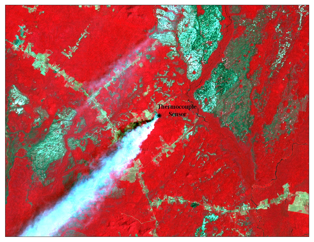
Figure 1. Snapshot of ASTER L1B data taken on January 28th 2003 (AST_L1B_003_01192003144204_03152003155855.hdf) displayed using a false color composite of VNIR bands 3N, 2 and 1 with the location of the thermocouple sensor shown.
Data Citation:
Cite this data set as follows:
Schroeder, W. and J. T. Morisette. 2008. LBA-ECO LC-23 Vegetation Fire Data, Roraima, Brazil: 2003. Data set. Available on-line [http://daac.ornl.gov] from Oak Ridge National Laboratory Distributed Active Archive Center, Oak Ridge, Tennessee, U.S.A. doi:10.3334/ORNLDAAC/887.
Implementation of the LBA Data and Publication Policy by Data Users:
The LBA Data and Publication Policy [http://daac.ornl.gov/LBA/lba_data_policy.html] is in effect for a period of five (5) years from the date of archiving and should be followed by data users who have obtained LBA data sets from the ORNL DAAC. Users who download LBA data in the five years after data have been archived must contact the investigators who collected the data, per provisions 6 and 7 in the Policy.
This data set was archived in July 2008. Users who download the data between July 2008 and June 2013 must comply with the LBA Data and Publication Policy.
Data users should use the Investigator contact information in this document to communicate with the data provider. Alternatively, the LBA Web Site [http://lba.inpa.gov.br/lba/] in Brazil will have current contact information.
Data users should use the Data Set Citation and other applicable references provided in this document to acknowledge use of the data.
Table of Contents:
- 1 Data Set Overview
- 2 Data Characteristics
- 3 Applications and Derivation
- 4 Quality Assessment
- 5 Acquisition Materials and Methods
- 6 Data Access
- 7 References
1. Data Set Overview:
Project: LBA (Large-Scale Biosphere-Atmosphere Experiment in the Amazon)
Activity: LBA-ECO
LBA Science Component: Land Use and Land Cover
Team ID: LC-23 (Morisette / Schroeder / Pereira)
The investigators were Morisette, Jeffrey Thomas; Pereira, Joao Antonio Raposo; Schroeder, Wilfrid; Csiszar, Ivan Andras; Giglio, Louis and Morton, Douglas Christopher . You may contact Schroeder, Wilfrid (schroeder@hermes.geog.umd.edu)
LBA Data Set Inventory ID: LC23_Vegetation_Fires_2003
This data sets contains ASTER satellite imagery over controlled burns in the State of Roraima in Northern Brazil on January 19 and 28, 2003, plus simultaneously collected soil and near-surface air temperature profiles on January 28th. The temperature data were collected with thermocouple sensors with Campbell data logger designed for measuring fire temperatures during the prescribed burn conducted on January 28, 2003.
Related Data Sets:
-
LBA-ECO LC-23 ASTER and MODIS Fire Data Comparison for Brazil: 2003-2004
2. Data Characteristics:
ASTER L1B Data
The ASTER high spatial resolution satellite data are available for visible-near infrared (15m resolution), short wave infrared (30m) and thermal infrared (90m) bands. Two sets of imagery were collected over Roraima state - Brazil covering a strip of approximately 180 x 60km each on January 19 and 28, 2003. Each date has one prescribed burn and many other opportunistic fires. Data format is ASTER L1B HDF. There is a corresponding *.met file (metadata file) for each .hdf file.
Though these files can be opened using any standard hdf viewer, ENVI can recognize the bands and georegistration automatically. The companion documment, ASTER_GeoRef_FINAL.pdf,gives a good description of how to georeference ASTER L1B data and to open the files in ERDAS Imagine and also older ENVI versions.
The ASTER Level-1B Registered Radiance at the Sensor product contains radiometrically calibrated and geometrically co-registered data for all the channels acquired previously through the telemetry streams of the 3 different telescopes in Level-1A. This product is created by applying the radiometric calibration and geometric correction coefficients to the Level-1A data. Both intra-telescope and inter-telescope registration correction for all the bands has been accomplished relative to the reference band of each sub-system. The Level-1B radiance product offers the same number of bands at the same resolution as the Level-1A product. Level-1B data provide the input for generating higher Level-2 geophysical products.
(Since March 2000, the Ground Data System (GDS) facility in Tokyo, Japan produced the Level-1B data sets, and sent them to the Land Processes (LP) Distributed Active Archive Center (DAAC) for archiving, distribution, and higher-level processing [https://lpdaac.usgs.gov/products/aster_products_table/ast_l1b].)
Examples of the .hdf and .met files included are:
AST_L1B_003_01192003144147_06052003101611.hdfAST_L1B_003_01192003144147_06052003101611.hdf.met
AST_L1B_003_01192003144156_06052003101600.hdfAST_L1B_003_01192003144156_06052003101600.hdf.met
Thermocouple Data
The above ground and below ground fire temperature measurements were collected with thermocouple sensors with Campbell data logger designed for measuring fire temperatures during the prescribed burn conducted on January 28, 2003.
Data File Contents for Air Profile Measurements:
Lat = latitude in decimal degrees (+ north / - south)
Lon = longitude in decimal degrees (+ east / - west)
Coordinate = latitude and longitude pair of coordinates describing the thermocouple location
Day = Day of January 2003 (calendar date)
Hour = Local hour (hh)
Minute = Local minute (mm)
Second = Local second (ss)
30 centimeters = thermocouple temperature in degree Celsius at 30 centimeters above ground
1 meter = thermocouple temperature in degree Celsius at 1 meter above ground
2 meters = thermocouple temperature in degree Celsius at 2 meters above ground
4 meters = thermocouple temperature in degree Celsius at 4 meters above ground
Example Data Records for Air Profile Measurements (roraima_thermocouple_air_sample.csv):
|
,Lat,Lon,,Thermocouple Temperatures in Celsius,,, ... |
Data File Contents for Soil Profile Measurements:
Lat = latitude in decimal degrees (+ north / - south)
Lon = longitude in decimal degrees (+ east / - west)
Coordinate = latitude and longitude pair of coordinates describing the thermocouple location
Day = Day of January 2003 (calendar date)
Hour = Local hour (hh)
Minutes = Local minute (mm)
1 centimeter = thermocouple temperature in degree Celsius at 1 centimeter below ground
5 centimeters = thermocouple temperature in degree Celsius at 5 centimeters below ground
10 centimeters = thermocouple temperature in degree Celsius at 10 centimeters below ground
Example Data Records for Soil Profile Measurements (roraima_thermocouple_ground_sample.csv):
|
,Lat,Lon,Thermocouple Temperatures in Celsius,, ... |
Site boundaries: (All latitude and longitude given in degrees and fractions)
| Site (Region) | Westernmost Longitude | Easternmost Longitude | Northernmost Latitude | Southernmost Latitude | Geodetic Datum |
|---|---|---|---|---|---|
| Roraima (Roraima) | -63 | -60 | 5 | 0 | World Geodetic System, 1984 (WGS-84) |
Time period:
- The data set covers the period 2003/01/19 to 2003/01/28.
- Temporal Resolution: Daily
Platform/Sensor/Parameters measured include:
- TERRA (MORNING EQUATORIAL CROSSING TIME SATELLITE) / Advanced Spaceborne Thermal Emission and Reflection Radiometer (ASTER) / THERMAL PROPERTIES
- FIELD INVESTIGATION / THERMOCOUPLE / LAND SURFACE TEMPERATURE
3. Data Application and Derivation:
The ASTER Level-1B data set contains radiometrically calibrated DNs (in units of watts per meter2 per steradian per micrometer), quantized as 8-bit unsigned integers, for all the acquired bands. Notwithstanding the fact that the long name of an ASTER Level-1B is defined Registered Radiance at the Sensor they still only are scaled or calibrated radiances. These scaled DNs can be converted to at-sensor radiance using the Unit Conversion Coefficients (UCC) in the following manner: Radiance = (DN value - 1) * Unit Conversion Coefficient.
Refer to ASTER User Handbook included as a companion file, aster_user_guide_v2.pdf, for finding appropriate Conversion Coefficients Data useful for extraction of vegetation fire radiative parameters. ASTER acquisition had simultaneous airborne data collection over two prescribed burns in the study area (Roraima).
4. Quality Assessment:
ASTER data is good, quality assessment report same as defined by NASA's Jet Propulsion Laboratory. Thermocouple data measurements are accurate down to decimal of a degree Celsius.
5. Data Acquisition Materials and Methods:
ASTER imagery acquired during two prescribed burn dates. Thermocouple mounted on the prescribed burn of the 28th, above ground measurements initiated after temperatures reached 40 degrees Celsius, ending three hours after fire went through.
6. Data Access:
This data is available through the Oak Ridge National Laboratory (ORNL) Distributed Active Archive Center (DAAC) or the EOS Data Gateway.
Data Archive Center:
Contact for Data Center Access Information:
E-mail: uso@daac.ornl.gov
Telephone: +1 (865) 241-3952
7. References:
Morisette, J. T., L. Giglio, I. Csiszar, A. Setzer, W. Schroeder, D. Morton and C. O. Justice. 2007. LBA-ECO LC-23 ASTER and MODIS Fire Data Comparison for Brazil: 2003-2004. Data set. Available on-line [http://daac.ornl.gov] from Oak Ridge National Laboratory Distributed Active Archive Center, Oak Ridge, Tennessee, U.S.A. doi:10.3334/ORNLDAAC/839.