Get Data
Summary:
This data set provides (1) areal estimates of deforestation events (>25 ha) that were identified from 2001-2004 in Mato Grosso by the Brazilian Institute for Space Research (INPE) as part of the Program for the Estimation of Deforestation in the Brazilian Amazon (PRODES) and (2) the classification of the post-deforestation land use as either cropland, cattle pasture, or not in production (deforested areas that were never fully cleared or returned immediately to secondary forest) in the years after the large deforestation events from 2002-2005. Data are provided in ESRI shapefile format. There are five compressed (*.zip) data files with this data set. Each shapefile represents one year of post-deforestation land use.
Land use in the years following deforestation was estimated using annual time series of MODIS NDVI (normalized difference vegetation index) and EVI (enhanced vegetation index). Metrics of vegetation phenology derived annual time series of MODIS NDVI and EVI data were analyzed using a decision-tree classifier to characterize the major cover type in each area of new deforestation. Post-deforestation land use for each large deforestation event was classified based on the classification of MODIS phenology metrics for all years following deforestation during 2002-2005.
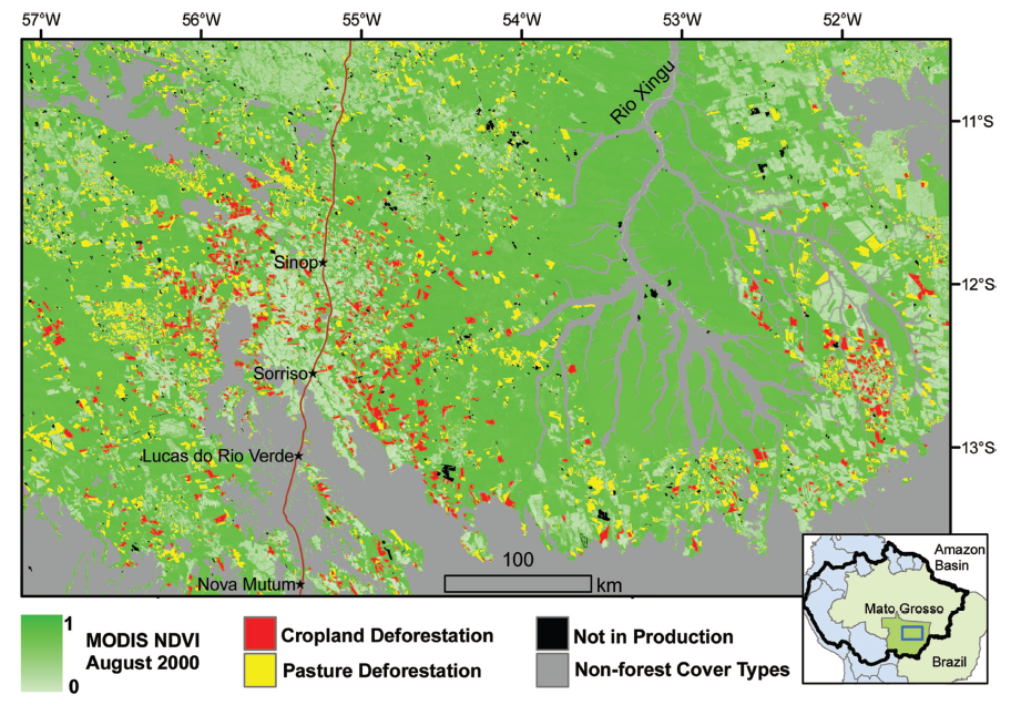
Figure 1. Classification of the post-deforestation land use as either cropland, cattle pasture, or not in production (deforested areas that were never fully cleared or returned immediately to secondary forest) in Mato Grosso state (2001–2004). Deforestation is concentrated along the existing agricultural frontier. (Inset) Location of the study area subset within Mato Grosso state and the Amazon Basin. From Morton et al. 2006.
Data Citation:
Cite this data set as follows:
Morton, D.C., R.S. DeFries, Y.E. Shimabukuro, L.O. Anderson, E. Arai, F. Esparito-Santo, R. Freitas, and J. Morisette. 2012. LBA-ECO LC-22 Post-deforestation Land Use, Mato Grosso, Brazil: 2001-2005. Data set. Available on-line [http://daac.ornl.gov] from Oak Ridge National Laboratory Distributed Active Archive Center, Oak Ridge, Tennessee, U.S.A.http://dx.doi.org/10.3334/ORNLDAAC/1099
Implementation of the LBA Data and Publication Policy by Data Users:
The LBA Data and Publication Policy [http://daac.ornl.gov/LBA/lba_data_policy.html] is in effect for a period of five (5) years from the date of archiving and should be followed by data users who have obtained LBA data sets from the ORNL DAAC. Users who download LBA data in the five years after data have been archived must contact the investigators who collected the data, per provisions 6 and 7 in the Policy.
This data set was archived in June of 2012. Users who download the data between June 2012 and July 2017 must comply with the LBA Data and Publication Policy.
Data users should use the Investigator contact information in this document to communicate with the data provider. Alternatively, the LBA website [http://lba.inpa.gov.br/lba/] in Brazil will have current contact information.
Data users should use the Data Set Citation and other applicable references provided in this document to acknowledge use of the data.
Table of Contents:
- 1 Data Set Overview
- 2 Data Characteristics
- 3 Applications and Derivation
- 4 Quality Assessment
- 5 Acquisition Materials and Methods
- 6 Data Access
- 7 References
1. Data Set Overview:
Project: LBA (Large-Scale Biosphere-Atmosphere Experiment in the Amazon)
Activity: LBA-ECO
LBA Science Component: Land Use and Land Cover
Team ID: LC-22 (DeFries / Shimabukuro)
The investigators were DeFriesi, Ruth; Shimabukuro, Yosio Edemir; Anderson, Liana ; Coura, Samuel Martins da Costa; Espirito-Santo, Fernando Del Bon; Hansen, Matthew C.; Jasinski, Ellen W; Latorre, Marcelo Lopes; Lima, Andre; Morton, Douglas and Piromal, Rodrigo Sbravatti. You may contact Morton, Douglas (douglas.morton@nasa.gov).
LBA Data Set Inventory ID: LC22_Post_Deforestation_LULC
This data set provides (1) areal estimates of deforestation events (>25 ha) that were identified from 2001-2004 in Mato Grosso by the Brazilian Institute for Space Research (INPE) as part of the Program for the Estimation of Deforestation in the Brazilian Amazon (PRODES) and (2) the classification of the post-deforestation land use as either cropland, cattle pasture, or not in production (deforested areas that were never fully cleared or returned immediately to secondary forest) in the years after the large deforestation events from 2001-2005.
2. Data Characteristics:
There are five compressed (*.zip) files with this data set. Each file includes the size and location of deforestation polygons
and their post-clearing land use for one year (2001 through 2005). Files are provided in zipped ESRI ArcGIS shapefiles. When extrapolated, each zip file contains six files (.dbf, .prj, .sbn, .sbx, .shp, .shx).
File names:
MT_post_deforestation_landuse_2001.zip
MT_post_deforestation_landuse_2002.zip
MT_post_deforestation_landuse_2003.zip
MT_post_deforestation_landuse_2004.zip
MT_post_deforestation_landuse_2005.zip
All files have the following projection parameters listed below:
- Projected Coordinate System: Sphere_Sinusoidal
- Projection: Sinusoidal
- False_Easting: 0.000000
- False_Northing: 0.000000
- Central_Meridian: 0.000000
- Geographic Coordinate System: GCS_Sphere
- Datum: D_Sphere
- Prime Meridian: Greenwich
- Angular Unit: Degree
The following attributes are available for each shapefile:
AREA_HA: Area of each PRODES deforestation polygon in hectares (ha)
PERIMETER: Perimeter of each PRODES deforestation polygon in meters (m)
LAND_USE: Classification of post-deforestation land use, with values 0-3 corresponding to the following classes:
0 = UNCLASSIFIED (areas not covered by MODIS tiles H12V10, H12V09 or H13V10)
1 = CROPLAND
2 = PASTURE
3 = NOT IN PRODUCTION (deforested areas that were never fully cleared or returned immediately to secondary forest)
CLASS: Post-deforestation land use
0 = UNCLASSIFIED (areas not covered by MODIS tiles H12V10, H12V09, or H13V10)
1 = CROPLAND
2 = PASTURE
3 = NOT IN PRODUCTION (deforested areas that were never fully cleared or returned immediately to secondary forest).
The following attributes are included only in shapefiles for deforestation in 2004 and 2005:
USE2005_06: Classification of post-deforestation land use based on
MODIS data from October 2005-September 2006, as described in Morton et al.
(2007). Values 0-3 corresponding to the following classes:
0 = UNCLASSIFIED
1 = CROPLAND
2 = PASTURE
3 = NOT IN PRODUCTION (deforested areas that were never fully cleared or returned immediately to secondary forest).
CLASS05_06: Post-clearing land use of cropland, pasture, not in production, or unclassified for deforestation in 2004 and 2005, as described in Morton et al. (2007)
0 = UNCLASSIFIED (areas not covered by MODIS tiles H12V10, H12V09, or H13V10)
1 = CROPLAND
2 = PASTURE
3 = NOT IN PRODUCTION
Site boundaries: (All latitude and longitude given in decimal degrees)
| Site (Region) | Westernmost Longitude | Easternmost Longitude | Northernmost Latitude | Southernmost Latitude | Geodetic Datum |
|---|---|---|---|---|---|
| Mato Grosso (Mato Grosso) | -61.00889 | -50.09556 | -7.47306 | -18.22806 | MODIS Sinusoidal |
Time period:
- The data set covers the period 2001/08/01 to 2005/07/31
- Temporal Resolution: Annual
Platform/Sensor/Parameters measured include:
- TERRA (MORNING EQUATORIAL CROSSING TIME SATELLITE) / MODIS (MODERATE-RESOLUTION IMAGING SPECTRORADIOMETER) / DEFORESTATION
3. Data Application and Derivation:
Multi-year analyses of the fate of deforested areas can be used to better understand the spatial and temporal patterns linking deforestation to social and economic drivers. See Morton et al. (2006), Morton et al.(2008), and van der Werf et al. (2009) for further discussion of the use and interpretation of the post-clearing land use data set described in this document.
4. Quality Assessment:
Field observations completed in March and July 2005 were used to validate site classifications. Overall accuracy for the 2005 classification was estimated at 89% and the same classification rules were applied to all the years in the study (Morton et al., 2006).
5. Data Acquisition Materials and Methods:
Site description:
Mato Grosso, the third largest state in Brazil, is part of western Amazonia to the north, while the southern portion is part of the Pantanal. The border of Mato Grosso and Tocantins is the location of wetlands of the Ilha do Bananal. Deforestation for large-scale cropland has resulted in 17% of forest loss in large clearings during 2001–2004, and pasture remains the dominant land use after deforestation.
Methods:
Field data were collected during June 2004, March 2005, and July 2005 on the location and condition of deforested areas, pastures, and croplands. These data were combined with satellite-based data provided by INPE before each field campaign and georeferenced to existing Landsat Enhanced Thematic Mapper Plus (ETM+) data provided by the Global Land Cover Facility with a spatial error of less than one pixel (30 m). We used PRODES digital results of the annual deforestation increment mapped using Landsat TM data from approximately August of 2001–2004 to identify the location and size of new clearings and summarize total deforested area, limiting our analysis to new clearings >25 ha based on the moderate resolution (250 m) of the MODIS sensor (Morton et al., 2006).
Estimates of 2005 deforestation were generated from MODIS red reflectance data contained in the MODIS/Terra Vegetation Indices 16-day L3 Global product at 250-m resolution and forest information from the PRODES 2004 deforestation analysis (Morton et al., 2006).
The data were then used to train a decision-tree classifier based on metrics of vegetation phenology from annual time series of MODIS NDVI (normalized difference vegetation index) and EVI (enhanced vegetation index) data, as described in Morton et al. (2006).
Large deforestation events were classified according to post-clearing land use as cropland, pasture, or not in production based on the majority cover type within the perimeter of the new deforestation event during the years following deforestation. Post-clearing land use for deforestation in 2001 included an assessment of four years of MODIS data following clearing (2002-2005). Post-clearing land use for 2002 deforestation was based on MODIS data for 2003-2005. Post-clearing land use in 2003 was based on MODIS data in 2004-2005. Deforestation in 2004 was included in Morton et al. (2006), with post-clearing land use based on MODIS data from a single year (2005). The classification of land use following 2004 deforestation was updated in 2007 using 2006 MODIS data, and post-clearing land use for 2005 deforestation was also estimated using MODIS data from 2006 (Morton et al., 2007). Therefore, two sets of classification results are included for 2004 deforestation -- one based a single year of MODIS data to evaluate post-clearing land use (Morton et al., 2006) and a second classification based on the trajectory of post-clearing land use for two years following deforestation (Morton et al., 2007).
6. Data Access:
This data is available through the Oak Ridge National Laboratory (ORNL) Distributed Active Archive Center (DAAC).
Data Archive Center:
Contact for Data Center Access Information:
E-mail:
uso@daac.ornl.gov
Telephone: +1 (865) 241-3952
7. References:
Morton, D.C., R.S. DeFries, Y.E. Shimabukuro, L.O. Anderson, E.Arai, F. del Bon Espirito-Santo, R. Frietas and J. Morisette. 2006. Cropland expansion changes deforestation dynamics in the southern Brazilian Amazon. PNAS 103: 14637-14641.
Morton, D.C., Y.E. Shimabukuro, B.F.T. Rudorff, A. Lima, R. Freitas, R.S. DeFries. 2007. Challenges for conservation at the agricultural frontier: deforestation, fire, and land use dynamics in Mato Grosso. Agua & Ambiente 2(1): 5-20.
Morton D.C., R.S. DeFries, J.T. Randerson, L. Giglio, W. Schroeder, G.R. van der Werf. 2008. Agricultural intensification increases deforestation fire activity in Amazonia. Global Change Biology 14: 2262-2275.
van der Werf, G.R., D.C. Morton, R.S. DeFries, L. Gilgio, J.T. Randerson, G.J. Collatz, P.S. Kasibhatla. 2009. Estimates of deforestation-induced carbon fluxes in the southern Amazon based on satellite data and biogeochemical modeling. Biogeosciences 6: 239-245.