Get Data
Summary:
This data set contains field observations, corresponding GPS points, and points and polygons of deforested areas in the state of Mato Grosso, Brazil, for the period March 17-24, 2005. Fieldwork was conducted in the regions surrounding Sinop, Mato Grosso, with specific emphasis on large clearings occurring in the Xingu Basin. The field campaign was designed to validate preliminary MODIS deforestation products designed to detect deforestation during the wet season. There are five data files with this data set: four shapefiles (.shp) and one comma-separated file (.csv).
DATA QUALITY STATEMENT: The Data Center has determined that there are questions about the quality of the data reported in this data set. The data set has missing or incomplete data, metadata, or other documentation that diminishes the usability of the products.
KNOWN PROBLEMS: The methods used to acquire the data were not well documented. The exact connection of observations in the *.csv files to the shapefiles is left up to the users. These are the field observations used to validate MODIS land cover classification as described in Morton et al., 2006.
Data Citation:
Cite this data set as follows:
DeFries, R., Y.E. Shimabukuro, D.C. Morton, L.O. Anderson, and F. del Bon Espirito-Santo. 2014. LBA-ECO LC-22 Field Validation of MODIS Deforestation Detection, Brazil, 2005. Data set. Available on-line (http://daac.ornl.gov) from Oak Ridge National Laboratory Distributed Active Archive Center, Oak Ridge, Tennessee, USA. http://dx.doi.org/10.3334/ORNLDAAC/1260
Implementation of the LBA Data and Publication Policy by Data Users:
The LBA Data and Publication Policy [http://daac.ornl.gov/LBA/lba_data_policy.html] is in effect for a period of five (5) years from the date of archiving and should be followed by data users who have obtained LBA data sets from the ORNL DAAC. Users who download LBA data in the five years after data have been archived must contact the investigators who collected the data, per provisions 6 and 7 in the Policy.
This data set was archived in December 2014. Users who download the data between December 2014 and November 2019 must comply with the LBA Data and Publication Policy.
Data users should use the Investigator contact information in this document to communicate with the data provider.
Data users should use the Data Set Citation and other applicable references provided in this document to acknowledge use of the data.
Table of Contents:
- 1 Data Set Overview
- 2 Data characteristics
- 3 Applications and Derivation
- 4 Quality Assessment
- 5 Acquisition Materials and Methods
- 6 Data Access
- 7 References
1. Data Set Overview:
Project: LBA (Large-Scale Biosphere-Atmosphere Experiment in the Amazon)
Activity: LBA-ECO
LBA Science Component: Land Use and Land Cover
Team ID: LC-22 (DeFries / Shimabukuro)
The investigators were DeFries-Bajpai, Ruth; Shimabukuro, Yosio Edemir; Anderson, Liana Oighenstein; Coura, Samuel Martins da Costa; Espirito-Santo, Fernando Del Bon; Hansen, Matthew C.; Jasinski, Ellen W.; Latorre, Marcelo Lopes; Lima, Andre; Morton, Douglas; Piromal, Rodrigo Sbravatti and DeFries, Ruth Sarah. You may contact Morton, Douglas C. (morton@geog.umd.edu).
LBA Data Set Inventory ID: LC22_MODIS_Field_Val_2005
This data set contains field observations, corresponding GPS points, and points and polygons of deforested areas in the state of Mato Grosso, Brazil, for the period March 17-24, 2005. Fieldwork was conducted in the regions surrounding Sinop, Mato Grosso, with specific emphasis on large clearings occurring in the Xingu Basin. The field campaign was designed to validate preliminary MODIS deforestation products designed to detect deforestation during the wet season.
Related data set:
LBA-ECO LC-22 Field Validation of MODIS Deforestation Detection, Brazil, 2003-2004. MODIS field validation data for 2003-2004 in Mato Grosso, Brazil.
2. Data Characteristics:
There are five data files with this data set. This includes four shapefiles (.shp) and one comma-separated file (.csv).
The data provide field observations and corresponding GPS points, preliminary data sets for MODIS deforestation detection in the state of Mato Grosso, Brazil for the period March 17-24, 2005.
Shapfefiles
All shapefiles have the following projection parameters:
Geographic Coordinate System:
GCS_WGS_1984 Datum: D_WGS_1984
Prime Meridian: Greenwich
Angular Unit: Degree
Table 1. Data file names and descriptions:
| File Name | Description |
|---|---|
| deforestation_polygons.zip |
This .zip file contains a shapefile (deforestation_polygons.shp) comprised of five files ( *.prj,
*.sbn, *.sbx, *.shp, and *.shx) and contains the estimated perimeters of 47 new deforestation areas (since August 2004) that were observed during the field campaign. The ID column further classifies each polygon based on the interpretation of MODIS time series imagery into the following classes: 0 = cleared before MOD13 033-2005, but since 273-2004 1 = new deforestation (from 033-2005) 2 = deforested old (brown) 3 = cleared, burned 4 = deforested area is clear |
| logging_areas.zip |
This .zip file contains a shapefile (logging_areas.shp)
with polygon geometry. The shapefile is comprised of six files (*.dbf,
*.prj, *.sbn, *.sbx, *.shp, and *.shx). Four areas that were initially
identified as potential wet-season deforestation were logged, but not
completely cleared. These polygons are isolated in this shapefile as a means for validating future deforestation detection algorithms and to help characterize the spectral and temporal patterns of logging in remotely sensed data. |
| covertype_march05.zip |
This .zip file contains a shapefile (covertype_march05.shp) with polygon geometry. The
shapefile is comprised of six files (*.dbf, *.prj,
*.sbn, *.sbx, *.shp, and *.shx). The shapefile contains 167 land cover type polygons of pasture and agricultural fields. Polygon boundaries were digitized over 2004 Landsat imagery to match field observations. Specific agricultural crops were recorded for each field where appropriate. These observations are specific to the field observation window--agricultural practices are dynamic and highly variable in Mato Grosso. Field notes are also listed in the table (.dbf) file for the shapefile. |
| gps_points_march05.zip | This .zip file contains a shapefile (gps_points_march05.shp) with point geometry. The shapefile is comprised of six files (*.dbf, *.prj, *.sbn, *.sbx, *.shp, and *.shx). Shapefile with the location of additional observations. |
| gps_points_march05.csv: | This file provides descriptions for each waypoint including latitude, longitude, date, and comments.projection /datum: WGS84 lat/long. |
Site boundaries: (All latitude and longitude given in decimal degrees)
| Site (Region) | Westernmost Longitude | Easternmost Longitude | Northernmost Latitude | Southernmost Latitude | Geodetic Datum |
|---|---|---|---|---|---|
| Mato Grosso - Sinop (Mato Grosso-Xingu Basin) | -55.75 | -54.28333 | -11.5 | -13.13335 | World Geodetic System, 1984 (WGS-84) |
Time period:
- The data set covers the period 2005/03/17 to 2005/03/24.
- Temporal Resolution:Single date observations
Platform/Sensor/Parameters measured include:
- FIELD INVESTIGATION / GPS (GLOBAL POSITIONING SYSTEM) / LAND COVER
- TERRA (MORNING EQUATORIAL CROSSING TIME SATELLITE) / MODIS (MODERATE-RESOLUTION IMAGING SPECTRORADIOMETER / LAND COVER
- FIELD INVESTIGATION / HUMAN OBSERVER / FOREST
3. Data Application and Derivation:
Land cover polygons (crop type, pasture, deforestation, and logging) are designed for training and validation of deforestation detection and land cover classification algorithms. Wet-season deforestation observations are critical to evaluate the temporal dynamics of deforestation in this region.
4. Quality Assessment:
Data were checked for internal consistency, and observations at individual GPS point locations and polygons represented consensus from four observers.
Problems identified by the Oak Ridge National Laboratory (ORNL) Distributed Active Archive Center (DAAC):
The methods used to acquire the data were not well documented. The exact connection of observations in the *.csv files to the shapefiles is left up to the users. These are the field observations used to validate MODIS land cover classification as described in Morton et al., 2006.
5. Data Acquisition Materials and Methods:
The goal of this study was to develop, test, and validate simple and efficient methods for the annual or more frequent monitoring of deforestation in the Brazilian Amazon as a basis for prioritizing high-resolution analyses and characterizing recent deforestation dynamics. The focal area for the campaign was the region surrounding Sinop, Mato Grosso, with specific emphasis on large clearings occurring in the Xingu Basin.
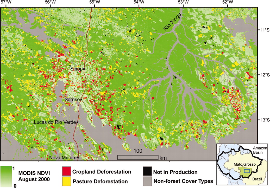
Figure 1. Tropical deforestation for cropland agriculture in Mato Grosso state (2001–2004) is concentrated along the existing agricultural frontier. (Inset) Location of the study area subset within Mato Grosso state and the Amazon Basin (Morton et al., 2006).
Field data on the location and condition of deforested areas, pastures, and cropland were collected during March 17-24, 2005 and scaled from Global Positioning System point observations to polygon training data by digitizing feature boundaries on near-coincident Landsat Thematic Mapper (TM) data. Landsat TM data were provided by INPE before the field campaign and georeferenced to existing Landsat Enhanced Thematic Mapper Plus (ETM+) data provided by the Global Land Cover Facility with a spatial error of less than one pixel (30 m) (Morton et al., 2006).
PRODES digital results of the annual deforestation increment mapped using Landsat TM data from approximately August of 2001–2004 for the state of Mato Grosso was used to identify the location and size of new clearings and summarize total deforested area. Our analysis was limited to new clearings greater than 25 ha based on the moderate resolution (250 m) of the MODIS sensor (Anderson et al., 2005, Justice et al., 1998, Morton et al., 2005). Estimates of 2005 deforestation in Mato Grosso State were generated from MODIS red reflectance data contained in the MODIS_Terra Vegetation Indices 16-day L3 Global product at 250-m resolution (Huete et al., 2002) and forest information from the PRODES 2004 deforestation analysis (Morton et al., 2006).
For additional related information and data regarding the 2003-2004 MODIS field validation campaign, refer to the data set LBA-ECO LC-22 Field Validation of MODIS Deforestation Detection Products, 2003-2004.
PRODES deforestation data, including remaining forest cover, for the Brazilian Amazon can be downloaded in shapefile or Spring format at: http://www.obt.inpe.br/prodes.
6. Data Access:
This data set is available through the Oak Ridge National Laboratory (ORNL) Distributed Active Archive Center (DAAC).
Data Archive Center:
E-mail: uso@daac.ornl.gov
Telephone: +1 (865) 241-3952
7. References:
Anderson, L.O., Y.E. Shimabukuro, R.S. DeFries, and D.C. Morton. (2005) IEEE Geosci Remote Sens Lett 2:315–318.
Huete, A.R., K. Didan, T. Miura, E.P. Rodriguez, X. Gao X, and L.G. Ferreira, (2002) Remote Sens Environ 83:195–213.
Justice, C.O., E. Vermote, J. Townshend, R.S. DeFries, D.P. Roy, V.V. Salomonson, J.L. Privette, G. Riggs, A. Strahler et al. (1998) IEEE Trans Geosci Remote Sens 36:1228–1249.
Morton, D.C., R.S. DeFries, Y.E. Shimabukuro, L.O. Anderson, F. Del Bon Espirito-Santo, R. Freitas, and J. Morisette. 2006. Cropland expansion changes deforestation dynamics in the southern Brazilian Amazon. PNAS, 103 (39) 14637-14641 doi:10.1073/pnas/0606377103.
Related Publications
- Morton, D.C., R.S. DeFries, Y.E. Shimabukuro, L.O. Anderson, F. Del Bon Espirito-Santo, M. Hansen, and M. Carroll. 2005. Rapid Assessment of Annual Deforestation in the Brazilian Amazon Using MODIS Data. Earth Interactions 9(8):1-22.
- Jasinski, E., D. Morton, R. DeFries, Y. Shimabukuro, L. Anderson, and M. Hansen. 2005. Physical Landscape Correlates of the Expansion of Mechanized Agriculture in Mato Grosso, Brazil. Earth Interactions 9(16):1-18.