Get Data
Summary:
This data set provides measurements for soil nutrients from areas that were selectively logged and from control areas in the Tapajos National Forest, Para Western Santarem, Brazil. Data are included for calcium (Ca), phosphorus (P), magnesium (Mg), nitrogen (N), aluminum (Al), iron (Fe), silicon (Si), carbon 13, nitrogen 15, and potassium (K) concentrations. In addition, data are included for Phosphorus fractionation which was performed on a subset of the soils, and soil bulk density measurements. The samples were from clay-dominated (oxisols) soils.
Samples were collected in March 2003 from four blocks logged in areas that result after selective logging: forest, tree-fall gaps, skids, roads, deck edges and deck centers.
There are two data files with this data set.
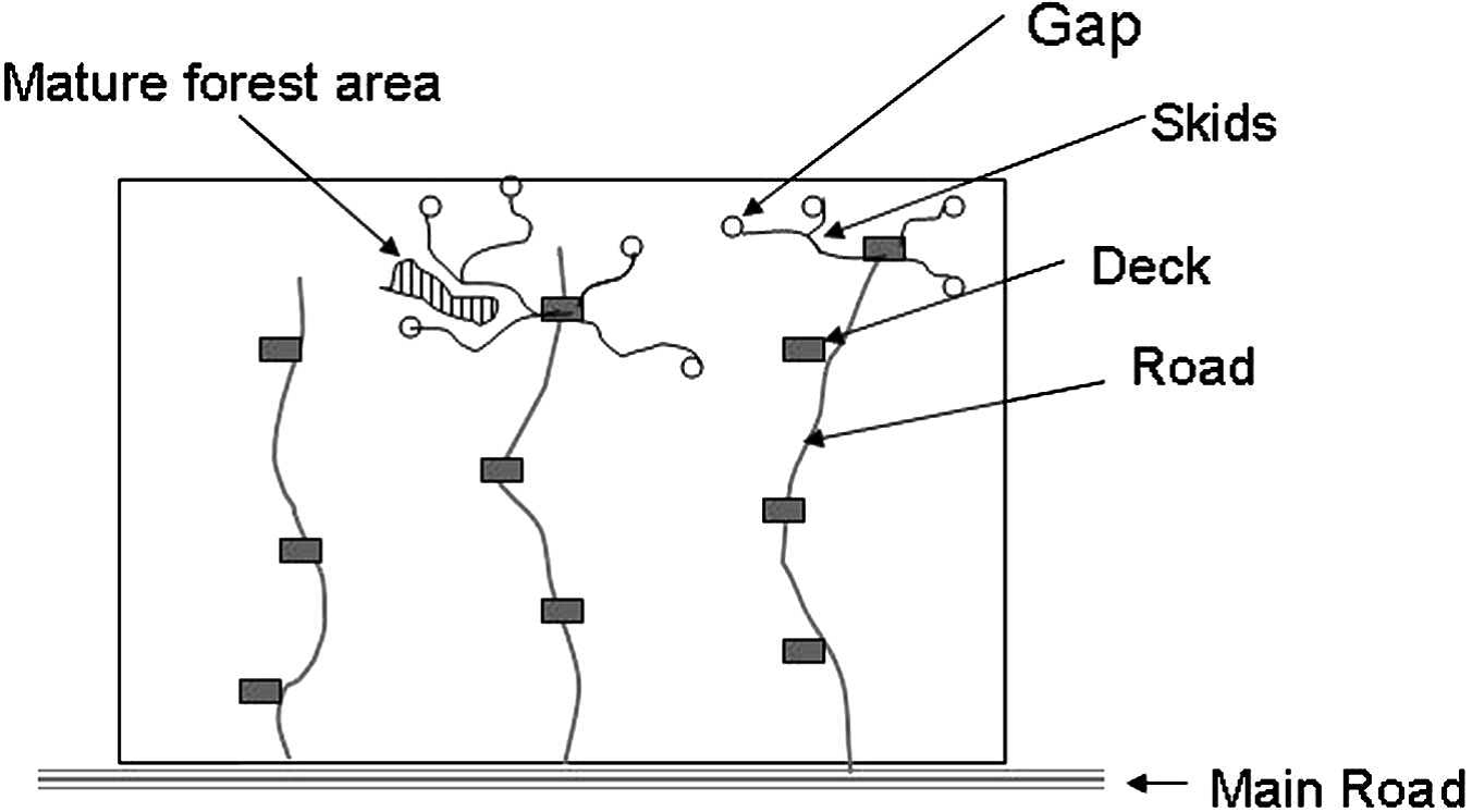
Figure 1. Diagram of a logging block. Image from Olander et al., 2005.
Data Citation:
Cite this data set as follows:
Asner, G.P., and L.P. Olander. 2014. LBA-ECO LC-21 Soil Characteristics, Logged Areas, Tapajos Forest, Para, Brazil: 2003. Available on-line [http://daac.ornl.gov] from the Oak Ridge National Laboratory Distributed Active Archive Center, Oak Ridge, Tennessee, USA. http://dx.doi.org/10.3334/ORNLDAAC/1236
Implementation of the LBA Data and Publication Policy by Data Users:
The LBA Data and Publication Policy [http://daac.ornl.gov/LBA/lba_data_policy.html] is in effect for a period of five (5) years from the date of archiving and should be followed by data users who have obtained LBA data sets from the ORNL DAAC. Users who download LBA data in the five years after data have been archived must contact the investigators who collected the data, per provisions 6 and 7 in the Policy.
This data set was archived in August 2014. Users who download the data between August 2014 and September 2019 must comply with the LBA Data and Publication Policy.
Data users should use the Investigator contact information in this document to communicate with the data provider.
Data users should use the Data Set Citation and other applicable references provided in this document to acknowledge use of the data.
Table of Contents:
- 1 Data Set Overview
- 2 Data Characteristics
- 3 Applications and Derivation
- 4 Quality Assessment
- 5 Acquisition Materials and Methods
- 6 Data Access
- 7 References
1. Data Set Overview:
Project: LBA (Large-Scale Biosphere-Atmosphere Experiment in the Amazon)
Activity: LBA-ECO
LBA Science Component: Land Use and Land Cover
Team ID: LC-21 (Asner / Bustamante / Silva)
The investigators were Asner, Gregory Paul; Bustamante, Mercedes M.C.; Silva, Jose Natalino Macedo; Broadbent, Eben North; Carlson, Kim; Carvalho, Ana Paula Ferreira; Hare, Anna Quinn; Knapp, David E.; Oliveira, Paulo Jose Silva Costa; Prado, Zayra Azeredo; Silva, Jose Salomao Oliveira and Villagomez, April Marie. You may contact Asner, Gregory P. (gpa@stanford.edu) and Knapp, David E. (deknapp@stanford.edu)
LBA Data Set Inventory ID: LC21_Soil_Characteristics
This data set provides measurements for soil nutrients from areas that were selectively logged and from control areas in the Tapajos National Forest, Para Western Santarem, Brazil. Data are included for calcium (Ca), phosphorus (P), magnesium (Mg), nitrogen (N), aluminum (Al), iron (Fe), silicon (Si), carbon 13, nitrogen 15, and potassium (K) concentrations. In addition, data are included for Phosphorus fractionation which was performed on a subset of the soils, and soil bulk density measurements. The samples were from clay-dominated (oxisols) soils.
Samples were collected in March 2003 from four blocks logged in areas that result after selective logging: forest, tree-fall gaps, skids, roads, deck edges and deck centers.
Related data sets:
LBA-ECO LC-13 GIS Coverages of Logged Areas, Tapajos Forest, Para, Brazil : 1996, 1998.
2. Data Characteristics:
There are two comma-delimited data files with this data set. The data are for soil nutrient analysis from areas that were selectively logged and from control areas in the Tapajos National Forest, Para Western Santarem, Brazil.
*The block and area descriptions were taken from the data set " LBA-ECO LC-13 GIS Coverages of Logged Areas, Tapajos Forest, Para, Brazil: 1996, 1998", available from the ORNL DAAC.
File #1. LC21_all_soil_nutrients.csv
| Column | Column Heading | Units/format | Description |
|---|---|---|---|
| 1 | Block | Logging block | |
| 2 | use | Area ID number: 0=control, 1=forest, 2=treefall, 3=skid trail, 4=road, 5= deck. | |
| 3 | Damage | R=road, P=patio, F=forest, S=skid trail, T=treefall | |
| 4 | Road | Road ID within each block | |
| 5 | Patio | Landing ID along each road | |
| 6 | Skid | Skid trail ID associated with each landing | |
| 7 | Treefall | Treefall gaps where the canopy falls and remains after being cut from the tree bole | |
| 8 | Forest | Unlogged forest at least 10 m from any deck (patio), skid, road, or gap | |
| 9 | Rep | Replicate samples in a Damage sampling area | |
| 10 | pH | Soil pH in water | |
| 11 | Ca | ug/g | Calcium concentration in soil |
| 12 | Mg | ug/g | Magnesium concentration in soil |
| 13 | K | ug/g | Potassuim concentration in soil |
| 14 | P | ug/g | Phosphorus concentration in soil |
| 15 | Fe | ug/g | Iron concentration in soil |
| 16 | Al | ug/g | Aluminum concentration in soil |
| 17 | Si | ug/g | Silicon concentration in soil |
| 18 | C | mg/g | Carbon concentration in soil |
| 19 | 15N | per mil | Nitrogen 15 concentration in soil |
| 20 | 13C | per mil | Carbon 13 concentration in soil, with respect to Pee Dee Belemnite (PDB) standard |
| 21 | C | % | Percent Carbon in soil |
| 22 | N | % | Percent Nitrogen in soil |
| 23 | C_N | Ratio of Carbon-Nitrogen in soil | |
| 24 | C | mg/g | Percent Carbon (from #20 ) as mg/g |
| 25 | N | mg/g | Percent Nitrogen (from #21) as mg/g |
| 26 | bulk density | mg/m3 | Soil bulk density |
File 2. LC21_Logging_soil_P_fractions.csv
*Sample ID: B=block #, R=road number, P=patio #, F, S,T, and R=location paired to the number of sample.
| Column | Column Heading | Units/format | Description |
|---|---|---|---|
| 1 | Batch | Batch number | |
| 2 | sample number | Sample number | |
| 3 | sample id | *Sample ID. For example, B16 R2 P1 F3=block 16, road 2, patio 1, and forest 3. | |
| 4 | Block | Logging block | |
| 5 | Road | Road ID within each block | |
| 6 | Patio | Patio ID within each block | |
| 7 | Skid | Skid trail ID within each block | |
| 8 | Damage | R=road, P=patio, F=forest, S=skid trail, T=treefall | |
| 9 | use | Area ID number: 0=control, 1=forest, 2=treefall, 3=skid trail, 4=road, 5=patio or deck | |
| 10 | rep | Sample number within collection site | |
| 11 | Resin extractable P | ug kg-1 soil | Resin strips (in KCl to flocculate soils) used to extract P |
| 12 | Bicarbonate extractable inorganic P | ug kg-1 soil | Bicarbonate (0.5M NaHCO3) to extract inorganic P |
| 13 | Bicarbonate extractable organic P | ug kg-1 soil | Bicarbonate (0.5M NaHCO3) to extract organic P |
| 14 | Sodium hydroxide extractable inorganic P | ug kg-1 soil | Sodium hydroxide (0.1M NaOH) to extract inorganic P |
| 15 | Sodium hydroxide extractable organic P | ug kg-1 soil | Sodium hydroxide (0.1M NaOH) to extract organic P |
| 16 | HCL extractable inorganic P | ug kg-1 soil | Hot concentrated acid (3.6M HCl) to extract inorganic P |
| 17 | HCL extractable organic P | ug kg-1 soil | Hot concentrated acid (3.6M HCl) to extract organic P |
| 18 | residual P | ug kg-1 soil | Residual P |
| 19 | sum of P fractions | ug kg-1 soil | Sum of all fractions from #s 10-16 above |
| 20 | total P digest | ug kg-1 soil | An independent measure of total soil P determined using the peroxide/sulfuric digest on a replicate soil sample |
The value -9999 represents values not provided with this data set
Site boundaries: (All latitude and longitude given in decimal degrees)
| Site (Region) | Westernmost Longitude | Easternmost Longitude | Northernmost Latitude | Southernmost Latitude | Geodetic Datum |
|---|---|---|---|---|---|
| Para Western - FLONA Tapajos (Para Western (Santarem)) | -55.25 | -54.83333 | -2.75 | -3.58333 | World Geodetic System, 1984 (WGS-84) |
Time period:
- The data set covers the period 2003/03/01 to 2003/03/01.
- Temporal Resolution: Single data collection
Platform/Sensor/Parameters measured include:
- LABORATORY / ICP-AES (INDUCTIVELY COUPLED PLASMA ATOMIC EMISSION / CALCIUM
- LABORATORY / ICP-AES (INDUCTIVELY COUPLED PLASMA ATOMIC EMISSION / POTASSIUM
- LABORATORY / ICP-AES (INDUCTIVELY COUPLED PLASMA ATOMIC EMISSION / MAGNESIUM
- LABORATORY / ICP-AES (INDUCTIVELY COUPLED PLASMA ATOMIC EMISSION / PHOSPHORUS
- LABORATORY / ICP-AES (INDUCTIVELY COUPLED PLASMA ATOMIC EMISSION / NUTRIENTS
- LABORATORY / MASS SPECTROMETERS / NITROGEN
- LABORATORY / MASS SPECTROMETERS / CARBON
- LABORATORY /ANALYSIS / ORGANIC MATTER
- LABORATORY /ANALYSIS / INORGANIC MATTER
3. Data Application and Derivation:
These data were collected to demonstrate how soil characteristics differ after a selective logging event.
4. Quality Assessment:
These data were reviewed and found to be reasonable and accurate.
5. Data Acquisition Materials and Methods:
Site description
The selective logging site is located in the northern part of the Tapajós National Forest (TNF) in Pará, Brazil, about 50 km south of Santarém, on a plateau that runs along the east side of the Tapajós River. The logging area is minimally transected by drainages. The soils are 70% clay dominated (ultisols and oxisols) and 30% sand dominated (ultisols; Silver et al. 2000). Mean annual temperature is 25 degrees C and rainfall averages 2,000 mm yr-1 with most inputs falling during the wet season from January through June (Nepstad et al. 2004).
Selective logging was carried out in blocks of approximately 100 ha, and had four spatially explicit impacts:
• logging roads;
• logging decks, where logs are temporarily stacked for movement off site;
• skids trails along which mechanical skidders pull logs from the forest to the decks;
• tree-fall gaps, where the canopy falls and remains after being cut from the tree bole.
Sample Collections
In March 2003, four blocks logged between August and October 2002 were sampled. These blocks were located on clay-dominated (oxisols) soils. Samples were ramdomly selected from two logging decks for sampling from each block. Samples were collected along the roads leading to the decks every 10 m along a 40-m transect (n= 5), and in the decks every 5 m along a central transect (25-m × 25-m) with three additional samples taken in the center spaced at least 2 m apart (n=7). Out from the decks, one skid was sampled every 10 m along a 40-m transect (n=5). At the first tree crown found, five samples were taken in and around the fallen crown (n =5). In the matrix of unlogged forest at least 10 m from any deck, skid, road, or gap, three to five control samples were taken at 10-m intervals along transects (n=3 or 5) (Olander et al., 2005).
In March 2003, we sampled four blocks logged between August and October 2002. These blocks were located on clay-dominated (oxisols) soils.
We randomly selected two logging decks for sampling from each block. We sampled the roads leading to the decks every 10 m along a 40-m transect (n=5), and in the decks every 5 m along a central transect (25-m × 25-m) with three additional samples taken in the center spaced at least 2 m apart (n=7). Out from the decks, one skid was sampled every 10 m along a 40-m transect (n=5). At the first tree crown found, five samples were taken in and around the fallen crown (n=5). In the matrix of unlogged forest at least 10 m from any deck, skid, road, or gap, three to five samples were taken at 10-m intervals along transects (n= 3 or 5).
Soil Nutrient Analysis
Soil samples were dried at 70 degrees C for 10 days and subsamples were ground and sieved (2-mm) with charcoal and large roots removed. Total C, N, 13C, and 15N were measured on an elemental analyzer mass spectrometer (Delta Plus, Finnigan Mat, San Jose, CA, USA) at CENA (University of Sao Paulo). Exchangeable P, Ca, K, and Mg were measured on 5g subsamples of soil extracted with Mehlich III (Tran and Simard 1993) and analyzed on the ICP-AES (SpectroFMV-3). pH was measured in water. Two analytical replicates per sample were analyzed using reference material (2710 Montana Soil, NIST) for total soil nutrients.
Phosphorus fractionations
The P fractionations were conducted on a subset of samples using a modified Hedley fractionation (Tiessen and Moir 1993; Townsend et al. 2002). Three analytical replicates were used for each sample. The soils were subjected to the following series of extractions:
- Resin strips (in KCl to flocculate soils)
- bicarbonate (0.5M NaHCO3)
- hydroxide (0.1M NaOH)
- hot concentrated acid (3.6M HCl)
- a final peroxide/sulfuric acid digest
This same digest was used on a portion of the bicarbonate, hydroxide, and acid extractions, so that the organic P content could be determined from the total minus the inorganic.
All samples were analyzed using the Murphy–Riley method (Murphy and Riley 1962) using a spectrophotometer (Shimadzu UV-1203). An independent measure of total soil P was determined using the peroxide/sulfuric digest on a replicate soil sample. The sum of all fractions was compared to this independent measure to provide a measure of confidence in the fractionation scheme.
6. Data Access:
These data are available through the Oak Ridge National Laboratory (ORNL) Distributed Active Archive Center (DAAC).
Data Archive Center:
Contact for Data Center Access Information:
E-mail: uso@daac.ornl.gov
Telephone: +1 (865) 241-3952
7. References:
Asner, G.P., M. Keller, R. Pereira, and J.C. Zweede. 2008. LBA-ECO LC-13 GIS Coverages of Logged Areas, Tapajos Forest, Para, Brazil : 1996, 1998. Data set. Available on-line [http://daac.ornl.gov] from Oak Ridge National Laboratory Distributed Active Archive Center, Oak Ridge, Tennessee, U.S.A.doi:10.3334/ORNLDAAC/893.
Murphy, J., and J. Riley, 1962: A modified single solution for the determination of phosphate in natural waters. Anal. Chem. Acta, 27, 31–36.
Nepstad, D. C., P. A. Lefebvre, J. U. L. Silva, J. Tomasella, P. Schlesinger, L. A. Solorzano, P.Moutinho, and D. G. Ray, 2004: Amazon drought and its implications for forest flammability and tree growth: A basin-wide analysis. Global Change Biol., 10, 704–717.
Olander, Lydia P., Mercedes M. Bustamante, Gregory P. Asner, Everaldo Telles, Zayra Prado, and Plinio Camargo. Surface soil changes following selective logging in an Eastern Amazon forest. Earth Interactions, vol. 9(2005 ): No.4
Silver, W. L., J. Neff, M. McGroddy, E. Veldkamp, M. Keller, and R. Cosme, 2000: Effects of soil
texture
on belowground carbon and nutrient storage in a lowland Amazonian forest ecosystem. Ecosystems, 3, 193–209.
Tiessen, H., and J. O. Moir, 1993: Characterization of available P by sequential extraction. Soil Sampling and Methods of Analysis, M. R. Carter, Ed., Lewis Publishers, 75–86.
Townsend, A. R., G. P. Asner, C. C. Cleveland, M. E. Lefer, and M. M. C. Bustamante, 2002: Unexpected changes in soil phosphorus dynamics along pasture chronosequences in the humid tropics. J. Geophys. Res., 107, 8067, doi:10.1029/2001JD000650.
Tran, T. S., and R. R. Simard. 1993. Mehlich III - Extractable elements. in M. R. Carter, editor. Soil sampling and methods of analysis. Lewis Publishers, Boca Raton FL.