Get Data
Revision date: December 10, 2014
Summary:
This data set provides measurements for soil physical and chemical properties, root depth and weight, leaf area index (LAI), plant area index (PAI), biomass, fraction of photosynthetically active radiation (fPAR), and ground-based reflectance measurements of soil and litter samples. The samples were collected from 23 areas within the Brazilian research sites of the Brasilia National Park (BNP) and Aguas Emnendadas Ecological Station (AE), Brasilia; Cangacu Research Center, Tocantins; and Tapajos National Forest, Para.
The research areas were in the most intensely stressed areas in Brazil, with rapid and aggressive land use conversions in forested and cerrado-transition areas. These field measurements were conducted from June to July 2002.
There are 61 comma-delimited (.csv) data files with this data set.
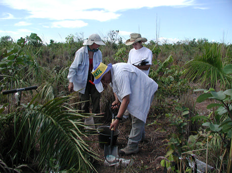
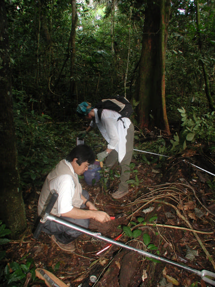
Figure 1. Field sampling in the cerrado and forest (photos taken from the data set companion file, LC-19_LBA_Soil_Field_2002.pdf).
Data Citation:
Cite this data set as follows:
Huete, A.R., L.G. Ferreira, and T. Miura. 2014. LBA-ECO LC-19 Soil and Vegetation Data for Cerrado and Forested Sites, Brazil: 2002. Data set. Available on-line (http://daac.ornl.gov) from Oak Ridge National Laboratory Distributed Active Archive Center, Oak Ridge, Tennessee, USA http://dx.doi.org/10.3334/ORNLDAAC/1261.
Implementation of the LBA Data and Publication Policy by Data Users:
The LBA Data and Publication Policy [http://daac.ornl.gov/LBA/lba_data_policy.html] is in effect for a period of five (5) years from the date of archiving and should be followed by data users who have obtained LBA data sets from the ORNL DAAC. Users who download LBA data in the five years after data have been archived must contact the investigators who collected the data, per provisions 6 and 7 in the Policy.
This data set was archived in December of 2014. Users who download the data between December 2014 and November 2019 must comply with the LBA Data and Publication Policy.
Data users should use the Investigator contact information in this document to communicate with the data provider.
Data users should use the Data Set Citation and other applicable references provided in this document to acknowledge use of the data.
Table of Contents:
- 1 Data Set Overview
- 2 Data Characteristics
- 3 Applications and Derivation
- 4 Quality Assessment
- 5 Acquisition Materials and Methods
- 6 Data Access
- 7 References
1. Data Set Overview:
Project: LBA (Large-Scale Biosphere-Atmosphere Experiment in the Amazon)
Activity: LBA-ECO
LBA Science Component: Land Use and Land Cover
Team ID: LC-19 (Huete / Ferreira / Sano)
The investigators were Huete, Alfredo R.; Ferreira, Laerte Guimaraes; Sano, Edson Eyji; Barbosa, Humberto Alves; Bustamante, Mercedes M.C.; Cardim, Pericles; Carvalho, Ana Paula Ferreira; Didan, Kamel; Espirito-Santo, Fernando Del Bon; Ferreira, Manuel Eduardo; Klink, Carlos Augusto; Lobo, Fabio Carneiro; McCubbin, Ian B; Miura, Tomoaki; Ratana, Piyachat and Shimabukuro, Yosio Edemir. You may contact Dr. Alfredo Huete (ahuete@ag.arizona.edu).
LBA Data Set Inventory ID:
This data set provides measurements for soil physical and chemical properties, root depth and weight, leaf area index (LAI), plant area index (PAI), biomass, fraction of photosynthetically active radiation (fPAR), and ground-based reflectance measurements of soil and litter samples. The samples were collected from 23 areas within the Brazilian research sites of the Brasilia National Park (BNP), Aguas Emnendadas Ecological Station (AE), Cangacu near Bananal Island, and Tapajos areas. The research areas were in the most intensely stressed areas in Brazil, with rapid and aggressive land use conversions in forested and cerrado-transition areas. These field measurements were conducted from June to July 2002.
2. Data Characteristics:
There are 61 data files in .csv format. Samples were collected from 23 areas within the Brazilian research sites of the Brasilia National Park (BNP), Aguas Emnendadas Ecological Station (AE), Cangacu near Bananal Island, and Tapajos areas, however, not all parameters included measurements from all areas. The research site descriptions are provided in Table 1.
The data files provide measurements for soil physical and chemical properties, Analytical Spectral Devices (ASD) spectroradiometer reflectance measurements of soil and litter samples, rooting depth, leaf area index (LAI), plant area index (PAI), fraction of photosynthetically active radiation (fPAR), and oven-dry biomass (g).
Soil Physical and Chemical Properties Data
The files for soil physical and chemical properties describe the research site (time, transect length, weather conditions, air temperature, longitude, latitude), and provide data for color, rooting depth, and bulk density for soils sampled.
The research sites include Brasilia, Tapajos, and Cangussu and there are eight data files per site in .csv format. There are also companion files for each site in .pdf format which provide the data collection information and photographs of the sites and samples.
Example data file names:
LC-19_LBA_Soil_AEcg_Field_2002.csv
LC-19_LBA_Soil_CAcw_Field_2002.csv
LC-19_LBA_Soil_TP83sl1_Field_2002.csv
Companion files for the sites:
LC-19_LBA_Soil_FieldSample_2002_Z.pdf where "Z" is Brasilia, Cangussu, or Santarem (for Tapajos). These files are also available upon request from the ORNL DAAC data center in .xls format as provided by the investigator for access to full-size images.
There are three files for soil physical-chemical data in .csv format.
1) LC-19_LBA_Soil_ChemPhysi_Field_2002: Soil samples for chemistry and texture analyses at
Embrapa Cerrados.
2) LC-19_LBA_Soil_BulkDensity_Field_2002: Bulk density data for
five sites at Brasilia National Park and by vegetation class. The sites include AE = Aguas Emendadas Ecological
Station; RJ = Rio de Janeiro Farm; CA = Cangucu; SA = Santana do Araguaia; and TP = Tapajos.
3) LC-19_LBA_Soil_Moisture_Field_2002:
Moisture Data for six sites and by vegetation class. The sites include BNP = Brasilia National Park; AE = Aguas
Emendadas Ecological Station; RJ = Rio de Janeiro Farm; CA = Cangucu; SA = Santana do Araguaia; and TP =
Tapajos.
ASD Measurements
There are 26 data files in .csv format for ASD measurements at 400-2400 wavelengths. The files are named by research site and vegetation class. The file headers provide specific sample types, sampling depths, and vegetation class descriptions. The site abbreviations are in the file names: AE = Aguas Emendadas Ecological Station; RJ = Rio de Janeiro Farm; CA = Cangucu; SA = Santana do Araguaia; and TP = Tapajos, and BNP =Brasilia National Park.
Example file names:
LC-19_LBA_ASD_Soil_CAcerradao_Field_2002.csv
LC-19_LBA_ASD_Soil_RJwot_Field_2002.csv
LC-19_LBA_ASD_Soil_SAcp_Field_2002.csv
Vegetation Data:
There are seven files of vegetation data and one file with site location data in .csv format. The data are presented by site and by vegetation class. The sites include BNP = Brasilia National Park; AE = Aguas Emendadas Ecological Station; RJ = Rio de Janeiro Farm; CA = Cangucu; SA = Santana do Araguaia; and TP = Tapajos.
The vegetation data include:
fPAR (one file)- The fraction of photosynthetically active radiation
CoverCompo (four files)- Cover component (percent cover); includes two files for understory and two files for
overtory percent cover.
LAI (one file)-
Plant area index and LAI-Leaf area index
Biomass (one file)- Oven-Dry Biomass
(g)
File names:
LC-19_LBA_LAI_Field_2002.csv
LC-19_LBA_Biomass_Field_2002.csv
LC-19_LBA_fPAR_Field_2002.csv
LC-19_LBA_CoverCompo-x_Field_2002.csv
(x = 1, 2, 3, or 4)
Table 1 . Research site descriptions
| Site # | Site | Latitude | Longitude | Description |
|---|---|---|---|---|
| 1 | BNP_CW | -15.73285 | -48.00338 | Brasilia National Park Cerrado woodland |
| 2 | BNP_WC | -15.60981 | -48.02948 | Brasilia National Park wooded Cerrado |
| 3 | BNP_SC | -15.58936 | -48.00663 | Brasilia National Park shrub Cerrado |
| 4 | AE_CW | -15.57276 | -47.59092 | Aguas Emendadas Cerrado woodland |
| 5 | AE_WC | -15.57845 | -47.62727 | Aguas Emendadas Wooded Cerrado |
| 6 | AE_CG | -15.54719 | -47.61507 | Aguas Emendadas Cerrado Grassland |
| 7 | RJ_WoT | -15.23455 | -47.69398 | Rio de Janeiro Farm without treatment |
| 8 | RJ_BU | -15.23003 | -47.69225 | Rio de Janeiro Farm burned |
| 9 | RJ_WT | -15.23142 -15.23142 |
-47.69372 -47.69441 |
Rio de Janeiro Farm with treatment (0-50m) Rio de Janeiro Farm with treatment (50-100m) |
| 10 | CA_P8 | -10.04658 | -49.89980 | Cangusu 8-year Pasture |
| 11 | CA_CW | -10.06633 | -49.90696 | Cangusu Cerrado woodland |
| 12 | CA_P3 | -10.06339 | -49.91322 | Cangusu 3-year pasture |
| 13 | CA_P1 | -10.06155 | -49.90547 | Cangusu 1-year pasture |
| 14 | SA_PA | -9.71817 | -50.40072 | Santana do Araguaia 20-year pasture |
| 15 | SA_CP | -9.74540 | -50.30674 | Santana Araguaia Capoeira |
| 16 | TP 67U | -2.8544 | -54.95977 | Upland Km67 primary forest |
| 17 | TP 67L | -2.84238 | -54.97889 | Lowland primary forest t |
| 18 | TP 89U | -3.12074 | -54.90156 | Upland Old Logged forest |
| 19 | TP 77RE | -3.01520 | -54.90799 | 88-year old regeneration forest |
| 20 | TP 93PA | -3.12714 | -54.94476 | 112-year old pasture |
| 21 | TP 83SL1 | -3.04599 | -54.95298 | selectively logged forest site 1 |
| 22 | TP 83SL2 | -3.03119 | -55.01072 | selectively logged forest site 2 |
| 23 | TP 103U | -9.74322 | -50.30741 | Upland old logged forest in Tapajos National Forest |
Site boundaries: (All latitude and longitude given in decimal degrees)
| Site (Region) | Westernmost Longitude | Easternmost Longitude | Northernmost Latitude | Southernmost Latitude |
|---|---|---|---|---|
| Brasilia - Brasilia National Park (Brasilia) | -48.08333 | -47.88333 | -15.58333 | -15.75000 |
| Brasilia - Aguas Emnendadas Ecological Station (AE) | -47.6 | -47.6 | -15.6 | -15.6 |
| Tocantins - Cangacu Research Center (Tocantins) | -49.9 | 49.9 | -10.1 | -10.1 |
| Para Western (Santarem) - km 67 Primary Forest Tower Site (Para Western (Santarem)) | -54.95900 | -54.95900 | -2.85700 | -2.85700 |
Time period:
- The data set covers the period 2002/06/10 to 2002/07/30.
- Temporal Resolution:
Platform/Sensor/Parameters measured include:
- FIELD INVESTIGATION / ANALYSIS / BIOMASS
- FIELD INVESTIGATION / LEAF CHARACTERISTICS / VEGETATION
- LABORATORY/ANALYSIS/SOIL CHEMISTRY
- FIELD INVESTIGATION / HUMAN OBSERVER / SOIL TEXTURE
- FIELD INVESTIGATION / THERMOMETER / SOIL TEMPERATURE
- LABORATORY/ANALYSIS/SOIL BULK DENSITY
3. Data Application and Derivation:
The results of this study will enable the detection of 'hotspots' of land conversion activities with the MODIS sensor; enable for their fine-scale analysis with the Landsat ETM+ sensor; and allow a time-series analysis with the AVHRR historical data. This will greatly aid seasonal and inter-annual carbon balance studies in the Cerrado and Amazon transition regions.
4. Quality Assessment:
Not available.
5. Data Acquisition Materials and Methods:
The samples were collected from 23 areas within Brazilian research sites described in Table 1. The research areas were in the most intensely stressed areas in Brazil, with rapid and aggressive land use conversions in forested and cerrado-transition areas.
Soil, Roots, and Litter Sampling and Measurements
Soil samples were collected at 25, 65, and 120 m along established transects at each site. If physical differences in soil samples were apprarent with depth, additional samples were collected (averaged depth changes). The samples were sieved in a 2-mm sieve, photographed, stored in separate zip-lock bags, and sent to the laboratory for chemical analysis.
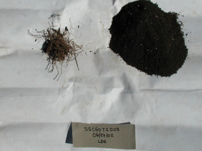
Figure 2. Roots and soil sample after seiving.
- Soil color was determined with a Munsell Color Chart.
- Soil temperature measurements were made along the transect at 25, 65, and 120-m and at depths of 5, 15,
and 30 cm. Wet and dry bulb air temperature measurements were made at the beginning of the transect.
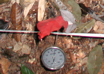
Figure 3. Soil temperature measurement.
- Rooting depth was determined with soil push probes sampled along the transect at 25, 65, and 120 m. The push probes were 24 inches to 61-cm in length. Soils and roots were weighed with an Ohas Scout Ii electronic balance and mass percentages were calculated (root mass/ root mass + soil mass).
- Surface litter was collected approximately 10-m away from the 250-m transect at reference positions 25, 65, and 120 m. Samples were digitally photographed and stored in Ziploc bags.
- ASD reflectance measurements were made on seived soil samples, and surface litter samples were placed on white plastic plates and measurements were taken on dry and wet samples. At CA-Cerrado, ASD measurements were made on soils sampled at 0-5 cm, 5-25 cm, and 25-30 cm.
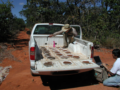
Figure 4. ASD measurements being taken of soil and litter samples.
Vegetation Sampling and Measurements
fAPAR measurements: Estimations of the fraction of Absorbed Photosynthetically Active Radiation (fAPAR) were made from June 10 through July 21, 2002. Transect, selected plant, and biomass measurements were made with a Decagon Accupar PAR-80 instrument. fAPAR was typically determined by 1) measuring the incident and reflected radiation for patches of bare soil, 2) measuring the incident and reflected radiation above the understory layer, and 3) measuring the transmitted radiation at the base of the understory.
- Transects-The predominant sampling method for total and overstory fAPAR was done along 100-m or 250-m transects. Measurements were taken at 10-m intervals from 0 m to 100 m. Measurements were taken at 25-m intervals from 100 m to 250 m. These locations coincided with LAI2000 measurements for the understory layer.
- Biomass-At sites where biomass was collected fAPAR measurements were taken from one of the samples before clipping.
- Selected Plants-At Aguas Emendadas the fAPAR of individual shrubs and trees was measured, along with their PAI, dimensions, and species.
In shrubby and forested areas a Licor LI-190SA Quantum Sensor was used in a clearing or on a tower to obtain PAR0 values. Accupar measurements were done within one hour of local noon to minimize the solar zenith angle. Unfortunately, by midday clouds often obscured the sun compromising the quality. Refer to the companion file LC-19_LBA_fAPARreport_Field_2002.pdf for additional information.
PAI Measurements: Estimations of the Plant Area Index (PAI) were made for transects and selected plants from June 10 through July 21, 2002, with one or more Licor LAI2000 instruments. The 90-degree cap was used for all measurements. Because direct lighting will depress PAI values, measurements were done before sunrise or when plants were shaded, naturally or artificially.
- Transects-The predominant sampling method for total and overstory PAI was done along 100-m or 250-m transects. Measurements were taken at 2-m intervals from 0 to 100 m. Measurements were taken at 5-m intervals from 100 m to 250 m. The instrument was configured to calculate a single PAI sample value from five measurements. At some sites the PAI of the grass understory layer or shrub understory layer was sampled along the transects with a set of ‘above’ and ‘below’ readings at the each location of ceptometer readings (see Table 2 in the companion file LC-19_LBA_PAIreport_Field_2002.pdf ). In forested areas, wide-angle digital photographs were taken of the tree canopy at the same locations.
- Biomass-For all biomass plots, one above and four below readings were taken before clipping with the biomass frame removed. A single PAI value was calculated for each biomass plot.
- Selected Plants-Individual shrubs and trees were selected at the Aguas Emendadas Ecological Station and Cangucu sites for PAI measurements. The PAI of these two plants were measured from two sides just below the lowest branches. Diameters were measured in orthogonal directions and averaged. Their heights and species names were also recorded. Wide-angle digital images were taken of each individual.
For additional general information regarding the 2002 LBA Field Campaign in Brazil, refer to the companion file LC-referenced i19_LBA_Soil_Field.pdf.
6. Data Access:
This data set is available through the Oak Ridge National Laboratory (ORNL) Distributed Active Archive Center (DAAC).
Data Archive Center:
E-mail: uso@daac.ornl.gov
Telephone: +1 (865) 241-3952
7. References:
Yoshioka, H., Miura, T., Yamamoto, H., and A. Huete. 2003. An Isoline-Based Translation Technique of Spectral Vegetation Index Using EO-1 Hyperion Data. IEEE Transactions on Geoscience and Remote Sensing, 41: 1363-1372.
Related Publications
- Ratana, P., A.R. Huete, and L. Ferreira. 2005. Analysis of Cerrado Physiognomies and Conversion in the MODIS Seasonal-Temporal Domain. Earth Interactions 9(3):1-22.
- Ferreira, L.G., H. Yoshioka, Y. Huete, and E.E. Sano. 2004. Optical characterization of the Brazilian savanna physiognomies for improved land cover monitoring of the cerrado biome: preliminary assessments from an airborne campaign over an LBA core site. Journal of Arid Environments 56(3):425-447.
- Ferreira, L.G., H. Yoshioka, A. Huete, and E.E. Sano. 2003. Seasonal landscape and spectral vegetation index dynamics in the Brazilian Cerrado: An analysis within the Large-Scale Biosphere-Atmosphere Experiment in Amazonia (LBA). Remote Sensing of Environment 87(4):534-550.
- Huete, A., K. Didan, T. Miura, E.P. Rodriguez, X. Gao, and L.G. Ferreira. 2002. Overview of the radiometric and biophysical performance of the MODIS vegetation indices. Remote Sensing of Environment 83(1-2):195-213.
- Yoshioka, H., Miura, T., Yamamoto, H., and A. Huete. 2003. An Isoline-Based Translation Technique of Spectral Vegetation Index Using EO-1 Hyperion Data. IEEE Transactions on Geoscience and Remote Sensing, 41: 1363-1372.