Get Data
Summary:
This data set provides physical roughness maps of vegetation canopies in the Amazon Basin. The images are estimates of aerodynamic roughness length (Z0) and zero plane displacement height (D0) at 1-km spatial resolution. The aerodynamic roughness length (Z0) is an important parameter to determine the vertical gradients of mean wind speed and the conditions for momentum transfer over a vegetated or bare rough surface.
The maps were produced from a multivariate regression model algorithm developed from field-measured vegetation structure and remote-sensing data. The data input sources included Shuttle Radar Topography Mission (SRTM) (Saatchi, 2013), JERS-1, MODIS, and field data from vegetation biomass plots over the Amazon basin, as well as tower-based wind profile measurements, and roughness parameters from LBA tower sites.
There are two GeoTIFF (.tif) files with this data set.

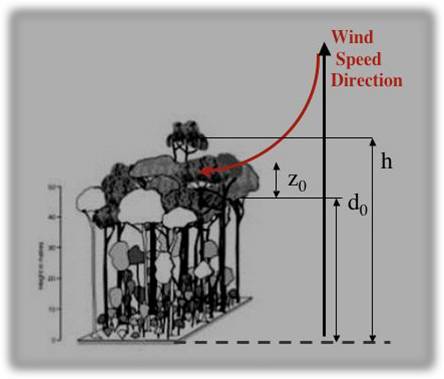
Figure 1. Diagram illustrating wind speed direction over vegetation canopy, aerodynamic roughness length (Z0) and zero plane displacement height (D0) (Saatchi, n.d.).
Data Citation:
Cite this data set as follows:
Saatchi,S., E. Rodriguez, S. Denning, R. Dubayah. 2013. LBA-ECO LC-15 Aerodynamic Roughness Maps of Vegetation Canopies, Amazon Basin: 2000. Data set. Available on-line [http://daac.ornl.gov] from Oak Ridge National Laboratory Distributed Active Archive Center, Oak Ridge, Tennessee, USA http://dx.doi.org/10.3334/ORNLDAAC/1182
Implementation of the LBA Data and Publication Policy by Data Users:
The LBA Data and Publication Policy [http://daac.ornl.gov/LBA/lba_data_policy.html] is in effect for a period of five (5) years from the date of archiving and should be followed by data users who have obtained LBA data sets from the ORNL DAAC. Users who download LBA data in the five years after data have been archived must contact the investigators who collected the data, per provisions 6 and 7 in the policy.
This data set was archived in August 2013. Users who download the data between August 2013 and July 2018 must comply with the LBA Data and Publication Policy.
Data users should use the investigator contact information in this document to communicate with the data provider.
Data users should use the data set citation and other applicable references provided in this document to acknowledge use of the data.
Table of Contents:
- 1 Data Set Overview
- 2 Data Characteristics
- 3 Applications and Derivation
- 4 Quality Assessment
- 5 Acquisition Materials and Methods
- 6 Data Access
- 7 References
1. Data Set Overview:
Project: LBA-ECO
Activity: Regional Vegetation Variables
LBA Science Component: Land Use and Land Cover
Team ID: LC-15 (Saatchi / Alvala)
The investigator was Saatchi, Dr. Sassan S. You may contact Saatchi, Dr. Sassan S. (sassan.saatchi@jpl.nasa.gov).
LBA Data Set Inventory ID: LC15_Roughness_Map
This data set provides roughness maps of vegetation canopies across the Amazon basin. The images are estimates of the aerodynamic roughness length (Z0) and the zero plane displacement height (D0). The aerodynamic roughness length (Z0) is an important parameter to determine the vertical gradients of mean wind speed and the conditions for momentum transfer over a vegetated or bare rough surface.
The maps were produced from a multivariate regression model algorithm developed from field-measured vegetation structure and remote-sensing data. The data input sources included the SRTM30 Digital Elevation Model (DEM) (Shuttle Radar Topography Mission (SRTM) February, 2000), JERS-1, MODIS, and field data from vegetation biomass plots over the Amazon basin, as well as tower-based wind profile measurements, and roughness parameters from LBA tower sites.
Related Data Set:
LBA-ECO LC-15 SRTM30 Digital Elevation Model Data, Amazon Basin: 2000. (image analysis for same time period)
2. Data Characteristics:
There are two GeoTIFF files (.tif) with this data set. The images
are estimates (maps) of aerodynamic roughness length (Z0) and zero plane
displacement height (D0) of vegetation canopies for the Amazon Basin at
1-km spatial resolution.
File #1: LC15_amazon_d0_map.tif
Projection parameters:
- Projected Coordinate System: WGS_1984_UTM_Zone_18S
- Projection: Transverse_Mercator
- Geographic Coordinate System: GCS_WGS_1984
- Datum: D_WGS_1984
- Prime Meridian: Greenwich
- Angular Unit: Degree
- Upper Left coordinates: -82.7209000, 13.8583000
- Lower Left coordinates: -82.7209000, -21.1277000
- Upper Right coordinates:-33.5739000, 13.8583000
- Lower Right coordinates:-33.5739000, -21.1277000
- Center coordinates: -58.1474000, -3.634700
Image Statistics
- Minimum: 1.000
- Maximum: 10.000
- Mean: 2.941
- Standard. deviation: 2.499
File #2: LC15_amazon_z0_map.tif
Projection parameters:
- Projected Coordinate System: WGS_1984_UTM_Zone_18S
- Projection: Transverse_Mercator
- Geographic Coordinate System: GCS_WGS_1984
- Datum: D_WGS_1984
- Prime Meridian: Greenwich
- Angular Unit: Degree
- Upper Left coordinates: -82.7209000, 13.8583000
- Lower Left coordinates: -82.7209000, -21.1277000
- Upper Right coordinates:-33.5739000, 13.8583000
- Lower Right coordinates:-33.5739000, -21.1277000
- Center coordinates: -58.1474000, -3.634700
Image Statistics
- Minimum: 0.000
- Maximum: 11.000
- Mean: 3.436
- Standard. deviation: 3.502
Site boundaries: (All latitude and longitude given in decimal degrees)
| Site (Region) | Westernmost Longitude | Easternmost Longitude | Northernmost Latitude | Southernmost Latitude | Geodetic Datum |
|---|---|---|---|---|---|
| Amazon Basin | -82.72083 | -47.0231 | 13.8583 | -23.4268 | World Geodetic System, 1984 (WGS-84) |
Time period:
- The data set covers the period: 2000/02/11 to 2000/02/22
- Temporal Resolution: one time campaign
Platform/Sensor/Parameters measured include:
- JERS-1 (JAPANESE EARTH RESOURCES SATELLITE-1) / SAR (SYNTHETIC APERTURE RADAR) / CANOPY CHARACTERISTICS
- SPACE SHUTTLES / SRTM (SHUTTLE RADAR TOPOGRAPHY MISSION) / CANOPY CHARACTERISTICS
- COMPUTER MODEL / ANALYSIS / AERODYNAMIC ROUGHNESS
- COMPUTER MODEL / ANALYSIS / VERTICAL WIND MOTION
3. Data Application and Derivation:
Roughness length (z0) and the zero plane displacement height (d0) are needed in many applications of surface hydrology or meteorology to estimate regional scale surface fluxes.
The distribution and shape of roughness elements can be derived from aerial photography or remote-sensing data.
4. Quality Assessment:
None provided. Note that while the methods for this data set are described on the authors web site http://www-radar.jpl.nasa.gov/carbon/ab/ar.htm, the sources for the Remote Sensing, Land Cover Map, and Field data used in addition to the SRTM data are not referenced.
5. Data Acquisition Materials and Methods:
Site description:
This research provided a method for estimating the aerodynamic roughness of the vegetation canopy of the Amazon basin, which is nearly 6,000,000 km2 and is dominated by dense forest. Savannas are found mostly to the north and south of the basin. Deforestation is concentrated along the southern and eastern part of the basin, along highways crossing the region and along the base of the Andes.

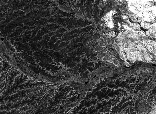
Figure 2. SRTM Surface Ruggedness and Roughness of Central Amazon (Saatchi, n.n.).
Model Data Input Sources:
-Remote-Sensing Data
- SRTM Digital Elevation Model (DEM) (1 km ) quantifying surface topographical features of elevation and slope, and SRTM Elevation Standard Deviation (1 km) quantifying surface ruggedness or topographical roughness. For additional information on the SRTM30, please see the following web site: http://www.jpl.nasa.gov/srtm/
This was the primary source of data for estimating the aerodynamic roughness. The SRTM aboard the Space Shuttle Endeavor launched on Feb. 11, 2000, for an 11 day mission. SRTM 30 arc-sec data were extracted from SRTM30 seamless data. SRTM30 is a near-global DEM comprising a combination of data from the SRTM Mission, flown in February, 2000, and the the U.S. Geological Survey's GTOPO30 data set (Saatchi, n.d.).
- JERS-1 radar backscatter at L-band (1 km) representing vegetation structure.
- JERS-1 radar texture measures (1 km) quantifying surface roughness and homogeneity.
- MODIS percent tree cover from Continuous Field Approach (1km) quantifying forest density and cover.
-Land Cover Map:
- A vegetation cover map was derived from the fusion of remote-sensing data (1 km).
-Field data:
- Data on vegetation structure, height, and roughness from selected biomass plots over the Amazon basin.
- Tower-based wind profile measurements and roughness parameters from LBA tower sites and published results.
Steps for the estimation of roughness length and image maps (retrieved from http://www-radar.jpl.nasa.gov/carbon/ab/ar_method.htm):
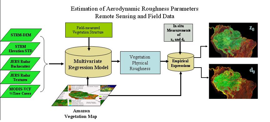
- A multivariate regression model algorithm was developed from field-measured vegetation structure and remote-sensing data (see above data sources) to estimate the physical roughness of vegetation.
- Published empirical expressions were used to translate vegetation physical roughness and type to aerodynamic roughness parameters Z0 and D0. Tower measurements of wind speed and roughness parameters were used to adjust the results to realistic values for vegetation types.
- Maps of aerodynamic roughness parameter classes were generated by using increments suitable for hydrological and meteorological surface models.
In addition, various statistical moments of the JERS-1 image mosaic are used in the fusion algorithm along with other regional data sets to improve the measurements on the vegetation surface structure and thus the roughness length. Final estimates of aerodynamic roughness are provided in the Z0 map at 1 km spatial resolution.

Figure 3. Steps and input sources for the production of aerodynamic roughness image maps (Saatchi, n.d.).
6. Data Access:
These data are available through the Oak Ridge National Laboratory (ORNL) Distributed Active Archive Center (DAAC).
Data Archive Center:
Contact for Data Center Access Information:
E-mail:
uso@daac.ornl.gov
Telephone: +1 (865) 241-3952
7. References:
Saatchi, S. 2013. LBA-ECO LC-15 SRTM30 Digital Elevation Model Data, Amazon Basin: 2000. Available on-line [http://daac.ornl.gov] from Oak Ridge National Laboratory Distributed Active Archive Center, Oak Ridge, Tennessee, USA http://dx.doi.org/10.3334/ORNLDAAC/1181
Saatchi, S. n.d. Projects in the Amazon Basin. Retrieved from http://www-radar.jpl.nasa.gov/carbon/ab/ar_method.htm.
Saatchi.,S., Rodriguez, E., S. Denning, and R. Dubayah, Estimation of Aerodynamic Roughness from Synergistic Use of Satellite Imagery, Proceeding of IGARSS, 2001, Sydney, Australia.