Get Data
Summary
This data set contains proportional estimates for the vegetative cover types of woody vegetation, herbaceous vegetation, and bare ground over the Amazon Basin for the period 2000-2001. These products were derived from all seven bands of the Moderate-resolution Imaging Spectroradiometer (MODIS) sensor onboard NASA's Terra satellite. A set of MODIS 32-day composites were used to create the vegetation cover types using the Vegetation Continuous Fields (VCF) (Hansen et al., 2002) approach which shows how much of a land cover such as "forest" or "grassland" exists anywhere on the land surface. The VCF product may depict areas of heterogeneous land cover better than traditional discrete classification schemes which shows where land cover types are concentrated.
The original MODIS products are 500-m spatial resolution and are derived from 2000-2001 data products. The data were resampled to 1-km resolution for the regional study under this project, and provided as 3 separate cover type files in ENVI and GeoTIFF file formats that are provided in six zipped files. These products are registered to the rest of the regional data sets over the Amazon basin.
These data are also available for download from the Global Land Cover Facility Website (http://modis.umiacs.umd.edu/).
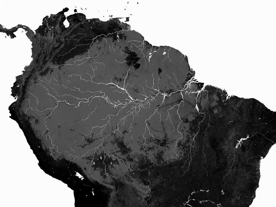
Figure 1. Vegetation Continuous Fields image for tree land cover type.
Data Citation:
Cite this data set as follows:
Hansen, M.C., R.S. DeFries, J.R.G. Townshend, M. Carroll, C. Dimiceli, R.A. Sohlberg, and S.S. Saatchi. 2011. LBA-ECO LC-15 Vegetation Cover Types from MODIS, 1-km, Amazon Basin: 2000-2001. Data set. Available on-line [http://daac.ornl.gov] from Oak Ridge National Laboratory Distributed Active Archive Center, Oak Ridge, Tennessee, U.S.A. http://dx.doi.org/10.3334/ORNLDAAC/1035
Implementation of the LBA Data and Publication Policy by Data Users:
The LBA Data and Publication Policy [http://daac.ornl.gov/LBA/lba_data_policy.html] is in effect for a period of five (5) years from the date of archiving and should be followed by data users who have obtained LBA data sets from the ORNL DAAC. Users who download LBA data in the five years after data have been archived must contact the investigators who collected the data, per provisions 6 and 7 in the Policy.
This data set was archived in August of 2011. Users who download the data between August 2011 and July 2016 must comply with the LBA Data and Publication Policy.
Data users should use the Investigator contact information in this document to communicate with the data provider. Alternatively, the LBA Web Site [http://lba.inpa.gov.br/lba/] in Brazil will have current contact information.
Data users should use the Data Set Citation and other applicable references provided in this document to acknowledge use of the data.
Table of Contents:
- 1 Data Set Overview
- 2 Data Characteristics
- 3 Applications and Derivation
- 4 Quality Assessment
- 5 Acquisition Materials and Methods
- 6 Data Access
- 7 References
1. Data Set Overview:
Project: LBA (Large-Scale Biosphere-Atmosphere Experiment in the Amazon)
Activity: LBA-ECO Regional Vegetation Variables
LBA Science Component: Land Use and Land Cover
Team ID: LC-15 (Saatchi / Alvala)
The investigator was Saatchi, Dr. Sassan S. You may contact Saatchi, Dr. Sassan S. (Saatchi@congo.jpl.nasa.gov)
LBA Data Set Inventory ID: LC15_MODIS_TreeCover
A set of MODIS 32-day composites were used to create the vegetation cover types using the continuous field approach. Data are included on the proportion of woody vegetation, proportion of herbaceous vegetation, and the proportion of bare ground.
2. Data Characteristics:
Code values: 0-100: Percent of pixel covered by land cover type; 253: water
Projection: Geographic with WGS84 datum
Data Files: This data set contains three images, each in both ENVI standard format and GeoTIFF format and are provided in six zipped files.
- The three zip files with ENVI files contain “_envi” in their file name and when extrapolated contain an ENVI image (*_envi.dat) and an ENVI image header file (*_envi.hdr).
- The three zip files with GeoTIFF files contain “_geotiff” in their file name and when extrapolated contain a GeoTIFF image (*_geotiff.tif) and a GeoTIFF header file (*_geotiff.tfw) file.
bare_envi.zip:
- bare_envi.dat
- bare_envi.hdr
bare_geotiff.zip:
- bare_geotiff.tif
- bare_geotiff.tfw
herbaceous_envi.zip:
- herbaceous_envi.dat
- herbaceous_envi.hdr
herbaceous_geotiff.zip:
- herbaceous_geotiff.tif
- herbaceous_geotiff.tfw
tree_envi.zip:
- tree_envi.dat
- tree_envi.hdr
tree_geotiff.zip:
- tree_geotiff.tif
- tree_geotiff.tfw
Header File Example: bare_envi.hdr
ENVI
description = {
C:\WorkSpace\DAAC\LBA\LC_15\LC15_MODIS_TreeCover\bare.dat}
samples = 5900
lines = 4200
bands = 1
header offset = 0
file type = ENVI Standard
data type = 1
interleave = bsq
byte order = 0
map info = {Geographic Lat/Lon, 1, 1, -82.72175685, 13.69440556, 0.0082204056075, 0.0082204056075,WGS-84}
coordinate system string = {GEOGCS["GCS_WGS_1984",DATUM["D_WGS_1984",SPHEROID
["WGS_1984",6378137.0,298.257223563]],PRIMEM["Greenwich",0.0],UNIT["Degree",0.017453292519943295]]}
band names = {
(Band 1}
Site boundaries: (All latitude and longitude given in decimal degrees)
| Site (Region) | Westernmost Longitude | Easternmost Longitude | Northernmost Latitude | Southernmost Latitude | Geodetic Datum |
|---|---|---|---|---|---|
| Amazon Basin | -82.72083 | -34.2213638 | 13.6944056 | -21.1273127 | World Geodetic System, 1984 (WGS-84) |
Time period:
- The data set covers the period 2000/10/31 to 2001/12/09
- Temporal Resolution: Products are derived from MODIS 2000-2001 images
Platform/Sensor/Parameters measured include:
- TERRA (MORNING EQUATORIAL CROSSING TIME SATELLITE) / MODIS (MODERATE-RESOLUTION IMAGING SPECTRORADIOMETER) / LAND COVER
3. Data Application and Derivation:
Standardized maps of forest cover from the regional to global scale are essential to a number of purposes including biogeochemical modeling, delineating remaining intact forest and woodland tracts for conservation and management concerns, and monitoring ecological succession. Repeated efforts at mapping over time can offer important insights into land use intensification and land cover change as well as offering insight into future dynamics. The synoptic view of global satellite data sets affords the best possibility of creating such maps. MODIS sensors offer much finer resolution, and greater spatial spectral response compared to AVHRR.
4. Quality Assessment:
To reduce the presence of cloud shadows, the data were converted to 40-day composites using a second darkest albedo (sum of B, G and R bands) algorithm. An extra 40 day composite period was added to compensate for data gaps resulting from temporary sensor outages.
Validation data for the percent tree cover maps based on the MODIS images were developed using ETM+/IKONOS at the 500-m, 1,000-m and 2,000-m scales.
5. Data Acquisition Materials and Methods:
This study employed approximately 1 year of MODIS imagery data (31 October 2000 to 9 December 2001).
The 7 MODIS land bands were used as inputs: blue (459-479 nm), green (545- 565 nm), red (620-670 nm), near infrared (841-876 nm), and mid-infrared (1,230-1,250, 1,628-1,652, 2,105-2,155 nm). A total of 68 metric were derived from the 7 MODIS bands and the Normalized Difference Vegetation Index (NDVI) and these were used as inputs for estimating percent tree cover. The derivation of the metrics and training data is fully described in Hansen et al. (2002).
The MODIS continuous fields of vegetation cover algorithm described in Hansen et al. (2002) is an automated procedure that employs a regression tree algorithm (Venables and Ripley, 1994). The regression tree is a nonlinear, distribution free algorithm that is highly suited for handling the complexity of global spectral land cover signatures. Outputs from the regression tree are further modified by a stepwise regression and bias adjustment per Hansen et al. (2003). The output of the algorithm is percent canopy cover defined as the amount of sunlight blocked by canopies equal to or greater than 5 meter in height.
6. Data Access:
This data is available through the Oak Ridge National Laboratory (ORNL) Distributed Active Archive Center (DAAC).
Data Archive Center:
Contact for Data Center Access Information:
E-mail: uso@daac.ornl.gov
Telephone: +1 (865) 241-3952
7. References:
Hansen, M.C., R.S. DeFries, J.R.G. Townsend, R.A. Sohlberg, C. Dimiceli and M. Carrol. 2002. Towards an operational MODIS continuous field of percent tree cover algorithm: Examples using AVHRR and MODIS data. Remote Sens. Environ. 83, 303-319.
Venables, W.N. and B.D. Ripley. 1994. Modern Applied Statistics with S-Plus. Springer-Verlag, New York 462 pp.
Hansen, M.C., R.S. DeFries, J.R.G. Townshend, M. Carroll, C. Dimiceli, and R. A. Sohlberg. 2003. Global Percent Tree Cover at a Spatial Resolution of 500 Meters: First Results of the MODIS Vegetation Continuous Fields Algorithm. Earth Interactions 7: Paper No. 10.