Get Data
Summary:
A simple GIS soil-water balance model for the Amazon Basin, called RisQue (Risco de Queimadasa -- Fire Risk), was used to conduct an analysis of spatial and temporal patterns of drought in moist tropical forests and the complex relationships between patterns of drought and forest fire regimes from 1995 through 2001.
The provided data products are the model output estimates of maximum plant-available soil water (PAWmax) at 10 m depth and model data inputs of monthly precipitation and evapotranspiration both at 8-km resolution.
RisQue estimates PAWmax at 10 m depth starting with a map of PAWmax (1-2 m depth) developed using 1,565 RADAMBRASIL soil texture profiles and empirical relationships between soil texture and critical soil water parameters and then interpolated to 8-km resolution. In RisQue, plant-available soil water (PAW) is depleted by monthly evapotranspiration estimated using the Penman Monteith equation and satellite-derived radiation and recharged by monthly precipitation.
There are three data files with this data set, two *.zip, and one GeoTIFF image (.tif). The *.zip files expand to 83 *.asc files of evapotranspiration and 89 *.asc files for precipitation data. The image (.tif) is a map of maximum percent available water at 10-m depth (predicted over 1995-2001). All the files in this data set are in standard arc/info asciigrid format at 8-km resolution.
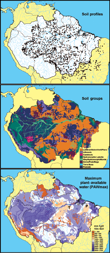
Figure 1. Maps used to develop the relationships between soil water, soil texture, and soil classes (maps a and b) towards the development of the PAWmax map (map c). Maps: (a) locations of RADAMBRASIL soil profiles, (b) groups of soil classes based on texture properties, and (c) maximum plant available water (PAWmax) for 10 m rooting depth (predicted over 1995-2001). The Tapajo´s National Forest (T) and Paragominas (P) are validation sites (Nepstad et al., 2004).
Data Citation:
Cite this data set as follows:
Nepstad, D.C, P.A. Lefebvre, U.L. Silva Jr., J. Tomasella, P. Schlesinger, L. Solorzano, P.R. Moutinho, and D. Ray. 2013. LBA-ECO LC-14 Modeled Soil and Plant Water Balance, Amazon Basin, 1995-2001. Data set. Available on-line (http://daac.ornl.gov) from Oak Ridge National Laboratory Distributed Active Archive Center, Oak Ridge, Tennessee, U.S.A. http://dx.doi.org/10.3334/ORNLDAAC/1147
Implementation of the LBA Data and Publication Policy by Data Users:
The LBA Data and Publication Policy [http://daac.ornl.gov/LBA/lba_data_policy.html] is in effect for a period of five (5) years from the date of archiving and should be followed by data users who have obtained LBA data sets from the ORNL DAAC. Users who download LBA data in the five years after data have been archived must contact the investigators who collected the data, per provisions 6 and 7 in the Policy.
This data set was archived in March 2013. Users who download the data between March 2013 and February 2018 must comply with the LBA Data and Publication Policy.
Data users should use the investigator contact information in this document to communicate with the data provider.
Data users should use the Data Set Citation and other applicable references provided in this document to acknowledge use of the data.
Table of Contents:
- 1 Data Set Overview
- 2 Data Characteristics
- 3 Applications and Derivation
- 4 Quality Assessment
- 5 Acquisition Materials and Methods
- 6 Data Access
- 7 References
1. Data Set Overview:
Project: LBA (Large-Scale Biosphere-Atmosphere Experiment in the Amazon)
Activity: LBA-ECO
LBA Science Component: Land Use and Land Cover
Team ID: LC-14 (Nepstad / Moutinho)
The investigators were Nepstad, Daniel Curtis; Moutinho, Paulo Roberto de Souza; Andrade, Sergio Viana de; Arce, Javier Alberto; Asner, Gregory Paul; Belk, Elizabeth Leslie; Brando, Paulo Monteiro; Breyer, Lace Medeiros; Cardinot, Gina Knust; Carvalho Jr., Oswaldo de; Costa, Luciana Miranda; Silva, Wanderley Rocha da; Dias-Filho, Moacyr Bernardino; Figueiredo, Ricardo de Oliveira; Guerrero, Jose Benito; Holbrook, Noel Michele; Kingerlee, Wendy; Klink, Carlos Augusto; Lameira, Wanja Janayna Miranda; Lefebvre, Paul A.; Maklouf, Eduardo Jorge; Markewitz, Daniel; Miranda, Heloisa S.; Monaco, Luciana Magalhaes; Morton, Douglas C.; Oliveira, Rafael Silva; Peters, Charles Merideth; Pinto, Flavia dos Santos; Ray, David G.; Santos, Alexandre Barbosa; Schlesinger, Peter; Schwalbe, Karen R.; Silva, Dulce Alves da; Solorzano, Luis Anibal Cardenas; Sternberg, Leonel and Steward, Corrina Dawn . You may contact Schlesinger, Peter (pschles@whrc.org) and Paul Lefebvre (paul@whrc.org).
LBA Data Set Inventory ID: LC14_RisQue
A simple GIS soil-water balance model for the Amazon Basin, called RisQue (Risco de Queimadasa -- Fire Risk), was used to conduct an analysis of spatial and temporal patterns of drought in moist tropical forests and the complex relationships between patterns of drought and forest fire regimes from 1995 through 2001.
The provided data products are the model output estimates of maximum plant-available soil water (PAWmax) at 10 m depth and model data inputs of monthly precipitation and evapotranspiration both at 8-km resolution.
RisQue estimates PAWmax at 10 m depth starting with a map of PAWmax (1-2 m depth) developed using 1,565 RADAMBRASIL soil texture profiles and empirical relationships between soil texture and critical soil water parameters and then interpolated to 8-km resolution. In RisQue, plant-available soil water (PAW) is depleted by monthly evapotranspiration estimated using the Penman Monteith equation and satellite-derived radiation and recharged by monthly precipitation.
2. Data Characteristics:
There are three data files with this data set, two input data
files (*.zip), and the model output file (.tif). All the files in this data set are
in standard arc/info asciigrid format at 8-km resolution with the same
header information below:
ncols 169
nrows 125
xllcorner -82
yllcorner -22
cellsize 0.25
NODATA_value -9999
File names:
etpi.zip: Evapotranspiration input data files. Temporal extent= 1996-2001.
prec.zip: Precipitation input data files. Temporal extent=1995-2001.
pawmax10m.tif: Maximum percent available water at 10-m depth data file.
File naming conventions:
etpi.zip expands to 83.asc files: etpi_mmyyyy.asc where mmyyyy ranges from 011996 to 102000, e.g.,
etpi_011996.asc
...
etpi_102000.asc
precip.zip expands into 89 .asc files: prec_mmyyyy.asc, where mmyyyy ranges from 011995 to 122001, e.g.,
prec_011995.asc
....
prec_122001.asc
pawmax10m.tif: only GeoTIFF file available for
20010101-20011231.
Site boundaries: (All latitude and longitude given in decimal degrees)
| Site (Region) | Westernmost Longitude | Easternmost Longitude | Northernmost Latitude | Southernmost Latitude | Geodetic Datum |
|---|---|---|---|---|---|
| Brazilian Amazon Basin (Legal Amazon Basin) | -82 | -34.035 | 9.2400 | -34 | WGS-84 |
Time period:
- The data set covers the period 1995/01/01 to 2001/12/31
- Temporal resolution: monthly
Platform/Sensor/Parameters measured include:
- COMPUTER MODEL / ANALYSIS / EVAPOTRANSPIRATION
- COMPUTER MODEL / ANALYSIS / PRECIPITATION AMOUNT
- COMPUTER MODEL / ANALYSIS / PLANT AVAILABLE WATER
3. Data Application and Derivation:
These data can be used to evaluate forest fire at the scale of the Amazon Basin.
4. Quality Assessment:
Modeled PAW to 10-m depth (PAW 10m) was similar to field measurements made in two Amazon forests. During the severe drought of 2001, PAW 10-m fell to below 25% of PAWmax in 31% of the region's forests and fell below 50% PAWmax in half of the forests.
PAW is influenced by the depth to the water table, the seasonal variation of this depth, and surface runoff. RisQue underestimates PAW in forests that receive subsurface water flow from neighboring regions of higher rainfall and that have water tables that rise into the rooting zone during the rainy season. RisQue overestimates PAW in forests in which steep slopes and/ or low infiltration rates are associated with surface runoff.
The paucity of soil texture profiles in non-Brazilian portions of northern and western Amazonia restricts the reliability of the PAWmax estimates for these regions.
RisQue tends to underestimate PAW at the Tapajos and Paragominas validation sites. Forty-seven percent of the validation points were within 20% of 1:l line, with the greatest errors close to PAW50.
5. Data Acquisition Materials and Methods:
A simple GIS soil-water balance model for the Amazon Basin, called RisQue (Risco de Queimadasa -- Fire Risk), was used to conduct an analysis of spatial and temporal patterns of drought in moist tropical forests and the complex relationships between patterns of drought and forest fire regimes from 1995 through 2001. The provided data products are the model output estimates of maximum plant-available soil water (PAWmax) at 10-m depth and model data inputs of monthly precipitation and evapotranspiration both at 8 km resolution.
RisQue estimates PAWmax at 10 m depth starting with a map of PAWmax (1-2 m depth) developed using 1,565 RADAMBRASIL soil texture profiles and empirical relationships between soil texture and critical soil water parameters and then interpolated to 8-km resolution. In RisQue, PAW is depleted by monthly evapotranspiration estimated using the Penman Monteith equation and satellite-derived radiation and recharged by monthly precipitation.
PAWmax Calculation Methods
PAWmax was calculated for the Brazilian Legal Amazon using tabular data on soil texture from RADAMBRASIL soil sample pits, using a combination of pedotransfer functions from Tomasella and Hodnett, 1998, and Saxton et al., 1986. Water retention was then interpolated to 8-km resolution, constrained by the RADAMBRASIL soils map polygons.
PAWmax was mapped by combining texture data from soil samples collected in the field with empirical relationships between soil texture and the critical soil physical parameters soil water field capacity (SWfc) and soil water held at –1.5MPa or less (permanent wilting point, SWpwp). Equations relating soil texture and carbon content to field capacity and permanent wilting were developed by Tomasella and Hodnett (1998) using soil water vs. matrix potential curves for Amazon soils.
The PAWmax map was later expanded to the Andean countries of the Amazon basin. Since soil texture information was not available for these areas, values from adjacent regions of similar soil types within Brazil were used assigned to polygons of the FAO soils map outside the Brazilian Amazon.
Soil moisture is depleted by ET as calculated using the Penman–Monteith equation with radiation inputs derived from the GOES-8 satellite. Soil moisture is recharged by fields of rainfall interpolated from a network of 266 weather stations.
Forest rooting depth is assumed to average 10m in the Amazon based upon previous deep soil studies in the region (Nepstad et al., 1994, 2002; Hodnett et al., 1995; Jipp et al., 1998).
Mean daily potential ET was estimated using the Penman–Monteith formulation (Monteith, 1965) with parameterizations provided by the ABRACOS climate experiment in the Amazon (Wright et al., 1996).
Model Inputs (Monthly precipitation (PPT) and evapotranspiration (ET) data sets acquired were prepared by Javier Tomasella at INPE/Centro de Previsa o de Tempo Clima (CPTEC); data sources included rain gauge data available at CPTEC and from cooperative station data distributed by NOAA-WMO)
ET
Basic meteorological data for ET were obtained from synoptic weather stations (i.e., stations that provide real-time measurements of air pressure, air temperature, relative humidity, and wind) from the global telecommunications system (GTS) network augmented by automatic weather stations of the CPTEC network. Since GTS synoptic stations provide data every 6 h, we used the values at 12 and 18 GMT to represent the diurnal cycle (Nepstad et al., 2004).
Data were also acquired from 266 weather stations, 129 of which were located within Amazonia. Since synoptic weather stations do not provide solar radiation data, a daily integrated estimation of total solar radiation was derived using satellite estimates (VIS 4 channel of GOES) using the algorithm proposed by Ceballos e Moura (1997).
Rainfall
Rainfall data were incorporated from synoptic stations and from the Brazilian Electrical Agency (ANEEL). Data was interpolated using kriging schemes to a spatial scale of 25 km.
Soil
Soil texture data were provided by the RADAMBRASIL (Brazil 1973-1983) project, and include 1,494 soil profiles, with each profile divided into soil horizons for which texture analyses were conducted. Most of the RADAMBRASIL soil texture profiles extend to depths of only 1-2 m so PAWmax of soil was estimated below the sampling depth by assuming that the lowermost horizon extended uniformly downward.
Model Validation
RisQue output (PAW) was validated through comparison with temporal trends of PAW measured to 10-m depth in a forest near Paragominas, eastern Amazon (Nepstad et al., 1994; Jipp et al., 1998) and in a forest near Santarem, in the east-central Amazon (Nepstad et al., 2002).
The relationship between patterns of PAW estimated by RisQue and patterns of forest flammability were examined using empirical relationships between PAW and LAI derived from field measurements in a large, rainfall exclusion experiment in the east-central Amazon (Nepstad et al., 2002).
6. Data Access:
These data are available through the Oak Ridge National Laboratory (ORNL) Distributed Active Archive Center (DAAC).
Data Archive Center:
Contact for Data Center Access Information:
E-mail: uso@daac.ornl.gov
Telephone: +1 (865) 241-3952
7. References
Hodnett MG, Pimental da Silva L, da Rocha HR et al. (1995). Seasonal soil water storage changes beneath central Amazonia rainforest and pasture. Journal of Hydrology, 170, 233–254.
Jipp P, Nepstad DC, Cassel K et al. (1998). Deep soil moisture storage and transpiration in forests and pastures of seasonally- dry Amazonia. Climatic Change, 39, 395–412.
Monteith JL (1965). Evaporation and environment. Symposia of the Society for Experimental Biology, 19, 205–234.
Ceballos JC, Moura GBA (1997). Solar radiation assessment using Meteosat 4-VIS imagery. Solar Energy, 60, 209–219.
Nepstad, D., P. Lefebvre, U.L. Da Silva, J. Tomasella, P. Schlesinger, L. Solorzano, P. Moutinho, D. Ray, and J.G. Benito. 2004. Amazon drought and its implications for forest flammability and tree growth: a basin-wide analysis. Global Change Biology 10(5):704-717.
Nepstad DC, Moutinho PRdS, Dias-Filho MB et al. (2002). The effects of rainfall exclusion on canopy processes and biogeochemistry of an Amazon forest. Journal of Geophysical Research, 107, 1–18.
Nepstad DC, Carvalho CJRd, Davidson EA et al. (1994). The role of deep roots in the hydrological and carbon cycles of Amazonian forests and pastures. Nature, 372, 666–669.
Saxton KE, Rawls WJ, Romberguer JS et al. (1986). Estimating generalized soil–water characteristics from texture. Soil Science Society of America Journal, 50, 1031–1036.
Tomasella J, Hodnett MG (1998). Estimating soil water retention characteristics from limited data in Brazilian Amazonia. Soil Science Society of America Journal, 163, 190–202.
Wright IR, Nobre CA, Tomasella J (1996). Towards a GCM surface parameterisation for Amazonia. In: Amazonian Deforestation and Climate (eds Gash JHC, Nobre CA, Roberts JR, Victoria RL), pp. 473–504. John Wiley and Sons, Chichester, UK. Amazon Drought and Forest Flammability 717 r 2004.