Get Data
Summary:
This data set contains GIS coverages constructed from measurements taken of logged areas in the Tapajos National Forest region of Para, Brazil in 1996 and 1998 (Asner et al., 2004). Coverages include log decks (patios), roads, skids trails, tree-fall locations, and block boundary. They are in ArcInfo SHAPE format (*.shp). The Tapajos data are in latitude/longitude using the WGS84 datum.
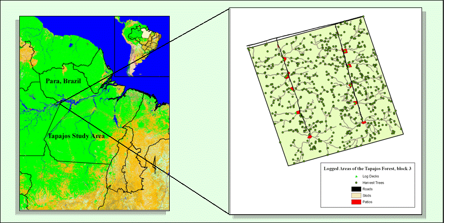
Figure 1. Location of logged areas in Tapajos National Forest and typical study block showing tree-fall location, skid trail, road, and log deck coverages.
Data Citation:
Cite this data set as follows:
Asner, G.P., M. Keller, R. Pereira, and J.C. Zweed. 2008. LBA-ECO LC-13 GIS Coverages of Logged Areas, Tapajos Forest, Para, Brazil: 1996, 1998. ORNL DAAC, Oak Ridge, Tennessee, USA. http://dx.doi.org/10.3334/ORNLDAAC/893
Implementation of the LBA Data and Publication Policy by Data Users:
The LBA Data and Publication Policy [http://daac.ornl.gov/LBA/lba_data_policy.html] is in effect for a period of five (5) years from the date of archiving and should be followed by data users who have obtained LBA data sets from the ORNL DAAC. Users who download LBA data in the five years after data have been archived must contact the investigators who collected the data, per provisions 6 and 7 in the Policy.
This data set was archived in July of 2008. Users who download the data between July 2008 and June 2013 must comply with the LBA Data and Publication Policy.
Data users should use the Investigator contact information in this document to communicate with the data provider. Alternatively, the LBA Web Site [http://lba.inpa.gov.br/lba/] in Brazil will have current contact information.
Data users should use the Data Set Citation and other applicable references provided in this document to acknowledge use of the data.
Table of Contents:
- 1 Data Set Overview
- 2 Data Characteristics
- 3 Applications and Derivation
- 4 Quality Assessment
- 5 Acquisition Materials and Methods
- 6 Data Access
- 7 References
1. Data Set Overview:
Project: LBA (Large-Scale Biosphere-Atmosphere Experiment in the Amazon)
Activity: LBA-ECO
LBA Science Component: Land Use and Land Cover
Team ID: LC-13 (Asner / Silva )
The investigators were Asner, Gregory Paul; Silva, Jose Natalino Macedo; Cooper, Amanda Naslund; Hare, Anna Quinn; Harris III, Albert Thomas; Keller, Michael M.; Knapp, David E.; Olander, Lydia Pauline; Palace, Michael William and Warner, Amanda Susan . You may contact Asner, Gregory P. (greg@globalecology.stanford.edu) and Knapp, David E. (deknapp@stanford.edu).
LBA Data Set Inventory ID: LC13_GIS_Tapajos
This data set contains GIS coverages constructed from measurements taken of logged areas in the Tapajos National Forest region of Para, Brazil in 1996 and 1998. Coverages include log decks (patios), roads, skids trails, tree-fall locations, and block boundary. They are in ArcInfo SHAPE format (*.shp). The Tapajos data are in latitude/longitude using the WGS84 datum.
Related Data Sets:
- LBA-ECO TG-07 Fallen Necromass in Tapajos, Fazenda Cauaxi, Juruena Forests in Brazil (Coarse woody debris data collected in the same area by co-authors on a related publication, Palace et al. 2007)
2. Data Characteristics:
These coverages are in ArcInfoSHAPE format (*.shp), which is readable by most GIS and image processing software. The available GIS layers include log decks (patios),roads, skids trails, tree-fall locations, and block boundary. The coordinates of the separate data layers are in latitude/longitude based on the WGS84 datum.
Data Files:
SHAPE format files (.dbf, .prj, .sbn, .sbx, .shp, .shp.xml, and .shx) have been combined and compressed as indicated below.
- Logging block boundaries for all of the blocks in the study area. See Figure 2.
logging_blocks_geo_shp.zip
- Location of decks in all of the blocks that have been analyzed. Blocks with red triangles in Figure 2.
decks_geo_shp.zip
- Location of boundaries, roads, and decks in specified blocks:
Block 15: tca4b15all_geo_shp.zip
Block 16: tca4b16all_geo_shp.zip
Block 17: tca4b17all_geo_shp.zip
Block 19: tca4b19all_geo_shp.zip
Block 21: tca4b21all_geo_shp.zip
- Location of boundaries, roads, decks, skid trails, and tree-falls in specified blocks:
Block 3: tca1b3_geo_shp.zip
Block 6: tca1b6_geo_shp.zip
Block 7: tca1b7_geo_shp.zip
Block 9: tca2b9_geo_shp.zip
Block 10: tca2b10_geo_shp.zip
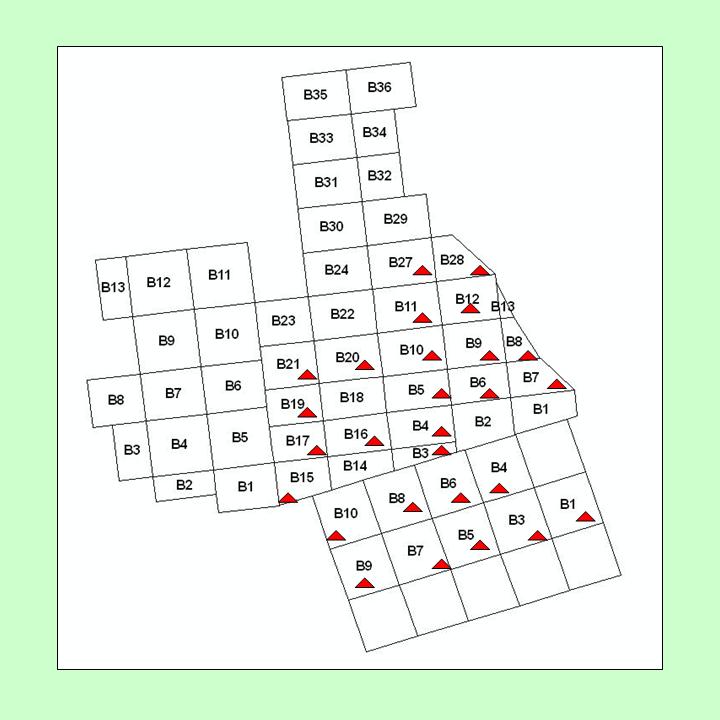
Figure 2. Logging blocks and blocks with logging decks in the Tapajos Forest study area.
Attribute information for deck coverage:
- DECK: is the deck identifier. "b15r2p2" means block 15, road 2, patio 2
- DECKNUMBER: a copy of the patio number or the number of skids
- Q_NUM: quadrant numberBLOCK_NUM: block number
- HARV_MONTH: month in which block was harvested
- HARV_YR: year in which block was harvested
Attribute information for other coverages:
The other shape files for patios, roads, etc. do not have any real attributes associated with them other than the standard ones that are used by the GIS software for indexing, etc.
Definitions for coverages:
* "Deck or Log Deck" means a place where logs are gathered in or near the forest for further transport to a processing mill or holding yard, sometimes called a "landing".
* "Skid or Skid Trail" means a temporary pathway principally used to drag or transport felled trees or logs or other material to a landing.
* "Road or Access Road" means a temporary or permanent access route.
Site boundaries: (All latitude and longitude given in degrees and fractions)
| Site (Region) | Westernmost Longitude | Easternmost Longitude | Northernmost Latitude | Southernmost Latitude | Geodetic Datum |
|---|---|---|---|---|---|
| Para - Tapajos Region (Para Western (Santarem)) | -56 | -54 | -2.25 | -3.5 | World Geodetic System, 1984 (WGS-84) |
Time period:
- The data set covers the period 1996/01/01 to 1998/12/31.
- Temporal Resolution: 1996/01/01 to 1998/12/31.
Platform/Sensor/Parameters measured include:
- FIELD INVESTIGATION / GPS (GLOBAL POSITIONING SYSTEM) / LANDSCAPE PATTERN
3. Data Application and Derivation:
These data when combined with hyper-spectral data can be applied to see how logging activity affects reflectance in multi- or hyper-spectral imagery.
4. Quality Assessment:
The GPS locations were visually compared with georeferenced imagery of the area.
5. Data Acquisition Materials and Methods:
These data were collected in the field using a Leica GPS unit.
Sensors used include:
- GPS (GLOBAL POSITIONING SYSTEM)
6. Data Access:
Data Set Users Guide: LC13_GIS_Tapajos.html
This data is available through the Oak Ridge National Laboratory (ORNL) Distributed Active Archive Center (DAAC) or the EOS Data Gateway.
Data Archive Center:
Contact for Data Center Access Information:
E-mail: uso@daac.ornl.gov
Telephone: +1 (865) 241-3952
7. References:
Asner, Gregory P., Michael Keller, Rodrigo Pereira Jr., Johan C. Zweede, and Jose N. M. Silva. 2004. Canopy Damage and Recovery Selective Logging in Amazonia: Field and Satellite Studies. Ecological Applications 14(4): S280-S298.
Related Publications :
- Pereira, R., J. Zweede, G.P. Asner, and M. Keller. 2002. Forest canopy damage and recovery in reduced-impact and conventional selective logging in eastern Para, Brazil. Forest Ecology and Management 168(1-3):77-89.
- Asner, G.P., M. Keller, R. Pereira, and J.C. Zweede. (2002) Remote sensing of selective logging in Amazonia - Assessing limitations based on detailed field observations, Landsat ETM+, and textural analysis. Remote Sensing of Environment 80(3):483-496.
- Palace, M., M. Keller, G.P. Asner, J.N.M. Silva, and C. Passos. 2007. Necromass in undisturbed and logged forests in the Brazilian Amazon. Forest Ecology and Management 238(1-3):309-318.