Get Data
Summary:
This data set contains GIS coverages constructed from measurements taken of four logged areas in Cauaxi Para, Brazil . Logged areas were selectively harvested either using conventional logging techniques or using reduced-impact logging (RIL) techniques (Pereira et al., 2002). Two areas were harvested with each techinique in 1996 and two additional areas were harvested in 1998. Coverages include log decks (patios), roads, skids trails, tree-fall locations, and logging area (block) boundary. These field surveys were conducted as part of an investigation of canopy damage following selective logging by two different techniques ( Asner et al., 2004).
Coverages are in ArcInfo interchange format (*.e00). The geographic projection of the data is UTM zone 22, South WGS84 datum.
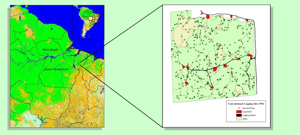
Figure 1. Location of logged areas in Cauaxi, Para and typical study block showing tree-fall location, skid trail, road, and log deck coverages.
Data Citation:
Cite this data set as follows:
Asner, G.P. 2008. LBA-ECO LC-13 GIS Coverages of Logged Areas, Cauaxi,Para,Brazil:1996, 1998. Data set.Available on-line[http://daac.ornl.gov] from Oak Ridge National Laboratory Distributed Active Archive Center, Oak Ridge, Tennessee, U.S.A. doi:10.3334/ORNLDAAC/890.
Implementation of the LBA Data and Publication Policy by Data Users:
The LBA Data and Publication Policy [http://daac.ornl.gov/LBA/lba_data_policy.html] is in effect for a period of five (5) years from the date of archiving and should be followed by data users who have obtained LBA data sets from the ORNL DAAC. Users who download LBA data in the five years after data have been archived must contact the investigators who collected the data, per provisions 6 and 7 in the Policy.
This data set was archived in July of 2008. Users who download the data between July 2008 and June 2013 must comply with the LBA Data and Publication Policy.
Data users should use the Investigator contact information in this document to communicate with the data provider. Alternatively, the LBA Web Site [http://lba.inpa.gov.br/lba/] in Brazil will have current contact information.
Data users should use the Data Set Citation and other applicable references provided in this document to acknowledge use of the data.
Table of Contents:
- 1 Data Set Overview
- 2 Data Characteristics
- 3 Applications and Derivation
- 4 Quality Assessment
- 5 Acquisition Materials and Methods
- 6 Data Access
- 7 References
1. Data Set Overview:
Project:LBA(Large-Scale Biosphere-Atmosphere Experiment in the Amazon)
Activity: LBA-ECO
LBA Science Component: Land Use and Land Cover
Team ID: LC-13 (Asner /Silva)
The investigators were Asner, Gregory Paul; Silva, Jose Natalino Macedo;Cooper, Amanda Naslund;Hare, Anna Quinn; Harris III, Albert Thomas; Keller, Michael M.; Knapp, David E.; Olander, Lydia Pauline; Palace, Michael William and Warner, Amanda Susan . You may contact Asner , Gregory P. (greg@globalecology.stanford.edu) and Knapp, David E. (deknapp@stanford.edu)
LBA Data Set Inventory ID: LC13_GIS_Cauaxi
This data set includes GIS
coverages
of
four selectively logged blocks on the
Fazenda
Cauaxi
(
Cikel
-Verde) in the State
of Para, Brazil.
Coverages
include log decks
(patios), roads, skids trails, tree-fall locations, and block boundary.
Coverages
are in
ArcInfo
interchange format (*.e00). The geographic projection of the data is
UTM zone
22, South in the WGS84 datum. Two sets of
coverages
are for conventionally logged blocks in 1996 and 1998. The other two
are for
reduced-impact logging in 1996 and 1998.
Related Data Set:
- LBA-ECO TG-07 Fallen Necromass in Tapajos,Fazenda Cauaxi,Juruena Forests in Brazil (Coarse woody debris data collected in the same area by co-authors on a paper linked to this data set)
2. Data Characteristics:
The data files for each parameter (e.g., skid trails, roads) are provided as ARC/INFO Exchange format (*.e00) files and are combined in four compressed files by logging technique and year:
Conventional_Logging_1996.zip
Conventional_Logging_1998.zip
Reduced_Impact_Logging_1996.zip
Reduced_Impact_Logging_1998.zip
Filenames follow these conventions:
aYY_bbbb.e00
where
a = c (Conventional Logging) or r (Reduced-Impact Logging)
YY = 96 (1996) or 98 (1998)
bbbb = coverage class: boundary, harvtrees , roads, skids, decks
Examples: r96_boundary.e00, r96_harvtrees.e00, r96_roads.e00, r96_skids.e00, r96_decks.e00
* "Deck or Log Deck" means a place where logs are gathered in or near the forest for further transport to a processing mill or holding yard, sometimes called a "landing".
* "Skid or Skid Trail" means a temporary pathway principally used to drag or transport felled trees or logs or other material to a landing.
* "Road or Access Road" means a temporary or permanent access route.
Coverages are in ArcInfo interchange format (*.e00). The geographic projection of the data is UTM zone 22, South, WGS84 datum. There are a number of GIS and image processing software packages that can read data in this format.
Site boundaries: (All latitude and longitude given in degrees and fractions)
| Site (Region) | Westernmost Longitude | Easternmost Longitude | Northernmost Latitude | Southernmost Latitude | Geodetic Datum |
|---|---|---|---|---|---|
| Para Eastern (Belem ) - Fazenda Cauaxi (Para Eastern ( Belem)) | -48.29060 | -48.29060 | -3.73130 | -3.73130 | GCS_WGS_1984 |
Time period:
- The data set covers the period 1996/01/01 to 1998/12/31.
- Temporal Resolution: Each site has coverage from 1996 and 1998.
Platform/Sensor/Parameters measured include:
- MAPS / HUMAN OBSERVER / LANDSCAPE PATTERNS
- COMPUTER MODEL / ANALYSIS / LANDSCAPE PATTERNS
- FIELD INVESTIGATION / GPS (GLOBAL POSITIONING SYSTEM) / LANDSCAPE PATTERNS
3. Data Application and Derivation:
These data were collected using GPS in the field along the center of the skid trail, road, or tree fall area. These field surveys were conducted as part of an investigation of canopy damage following selective logging by two different techniques (Asner et al., 2004).
4. Quality Assessment:
The GPS data were checked against imagery and existing maps of the area for accuracy of the road features and other visible features in the imagery or maps.
5. Data Acquisition Materials and Methods:
The two CL and two RIL blocks were inventoried and mapped prior to and following harvest operations. The number and location of trees felled were recorded. Road, log deck, and skid lengths and areas were measured and mapped using fiberglass measuring tapes and compasses. Road, skid, and log deck widths were also measured with a measuring tape at 50-m intervals. Tree locations, road, skid, and log deck data were transferred to paper maps at a scale of 1:1000. The maps were then digitized into a geographic information system (GIS Arc/Info) and geo-rectified using 124 field GPS measurements. The spatial data layers contain spatially explicit locations and areas of all roads, skids, log decks,and felled trees for each block.
Coverages lacked a defined projection. These .e00 files were imported into ArcMap, corrected, and exported back to .e00 format by ORNL DAAC.
Sensors used include:
- HUMAN OBSERVER
- ANALYSIS
- GPS (GLOBAL POSITIONING SYSTEM)
6. Data Access:
This data is available through the Oak Ridge National Laboratory (ORNL) Distributed Active Archive Center (DAAC).
Data Archive Center:
Contact for Data Center Access Information:
E-mail: uso@daac.ornl.gov
Telephone: +1 (865) 241-3952
7. References:
Asner, Gregory P., Michael Keller, Rodrigo Pereira Jr., Johan C. Zweede, and Jose N. M. Silva. 2004. Canopy Damage and Recovery After Selective Logging in Amazonia: Field and Satellite Studies. Ecological Applications 14(4): S280-S298.
Pereira, R., J. Zweede, G.P. Asner, and M. Keller. 2002. Forest canopy damage and recovery in reduced-impact and conventional selective logging in eastern Para, Brazil. Forest Ecology and Management 168(1-3):77-89.
Related Publications :
- Asner , G.P., M. Keller, R. Pereira, and J.C. Zweede . 2002. Remote sensing of selective logging in Amazonia - Assessing limitations based on detailed field observations, Landsat ETM+, and textural analysis. Remote Sensing of Environment 80(3):483-496.
- Asner , G.P., M. Keller, and J.N.M. Silva. 2004. Spatial and temporal dynamics of forest canopy gaps following selective logging in the eastern Amazon. Global Change Biology 10(5):765-783.
- Palace, M., M. Keller, G.P. Asner , J.N.M. Silva, and C. Passos . 2007. Necromass in undisturbed and logged forests in the Brazilian Amazon. Forest Ecology and Management 238(1-3):309-318.