Get Data
Summary:
This data set includes orthorectified Landsat ETM+ scenes across the Legal Amazon region. At least one scene is provided for each spatial tile, representing the most cloud-free retrievals from mid-1999 through late 2001 (Fig. 1). Dates are therefore not continuous but include scenes from July 8, 1999 to November 13, 2001. Data have been atmospherically corrected and orthorectified.
Data files (and format) included for each scene are: six multispectral bands (tif), two thermal bands (tif), one panchromatic band (tif), two preview files (jpg), and one metadata file (txt). The individual Geotiff files have been g-zipped and subsequently all of the files for a scene have been g-zipped together for ordering convenience.
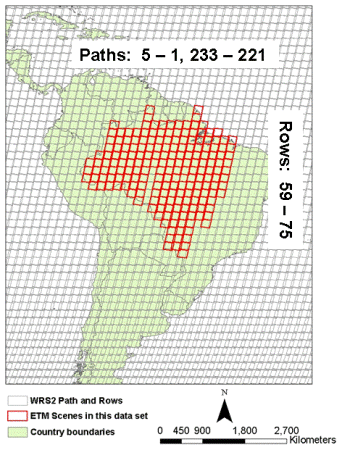
Figure 1. Spatial distribution of Landsat ETM+ scenes across the Legal Amazon region.
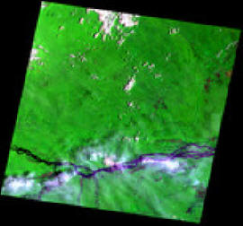
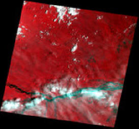
Figure 2. Example preview figures for the tile designated Path 1 and Row 60 on October 3, 2001. The left image (p001r060_7t20011003.742.preview.jpg) displays bands 7, 4 and 2. The right image (p001r060_7t20011003.preview.jpg) displays bands 4, 3 and 2.
Data Citation:
Cite this data set as follows:
TRFIC (Tropical Rain Forest Information Center, Basic Science and Remote Sensing Initiative, Michigan State University (http://www.trfic.msu.edu)). 2007. LBA-ECO LC-10 Orthorectified Landsat ETM+ Data for Legal Amazon: 1999-2001. Data set. Available on-line [http://www.daac.ornl.gov] from Oak Ridge National Laboratory Distributed Active Archive Center, Oak Ridge, Tennessee, U.S.A. doi:10.3334/ORNLDAAC/846.
Implementation of the LBA Data and Publication Policy by Data Users:
The LBA Data and Publication Policy [http://daac.ornl.gov/LBA/lba_data_policy.html] is in effect for a period of five (5) years from the date of archiving and should be followed by data users who have obtained LBA data sets from the ORNL DAAC. Users who download LBA data in the five years after data have been archived must contact the investigators who collected the data, per provisions 6 and 7 in the Policy.
This data set was archived in August of 2007. Users who download the data between August 2007 and July 2012 must comply with the LBA Data and Publication Policy.
Data users should use the Investigator contact information in this document to communicate with the data provider. Alternatively, the LBA Web Site [http://lba.inpa.gov.br/lba/] in Brazil will have current contact information.
Data users should use the Data Set Citation and other applicable references provided in this document to acknowledge use of the data.
Table of Contents:
- 1 Data Set Overview
- 2 Data Characteristics
- 3 Applications and Derivation
- 4 Quality Assessment
- 5 Acquisition Materials and Methods
- 6 Data Access
- 7 References
1. Data Set Overview:
Project: LBA (Large-Scale Biosphere-Atmosphere Experiment in the Amazon)
Activity: LBA-ECO
LBA Science Component: Land Use and Land Cover
Team ID: LC-10 (Skole / Pedlowski)
The investigators were Skole, David Lewis; Pedlowski, Marcos A.; Caldas, Marcellus Marques; Cameron, Stephen Robert; Chomentowski, Walter H.; Cochrane, Mark Alan; Matricardi, Eraldo A. T.; Oliveira, Pedro Mourao de; Salas, William A.; Silva, Andrea Maria Silveira e; Silva, Luiz Guilherme Teixeira de; Walker, Robert T.; Wood, Charles H. and Zhou, Yushuang. You may contact Skole, David Lewis (skole@msu.edu)
LBA Data Set Inventory ID: LC10_Landsat_ETM
This data set includes Landsat ETM+ coverage of the Legal Amazon region from July 1999 to November 2001.
For additional information, please see the following web site:
- Tropical Rain Forest Information Center at Michigan State University ( http://www.trfic.msu.edu )
Related_Data_Sets:
- LBA-ECO LC-10 Landsat TM Data for Legal Amazon: 1986-1994.
- LBA Regional Boundary for the Legal Amazon of Brazil, 8-km.
2. Data Characteristics:
This data set includes orthorectified Landsat ETM+ scenes across the Legal Amazon region. At least one scene is provided for each spatial tile, representing the most cloud-free retrievals from mid-1999 through late 2001. Dates are therefore not continuous and include scenes from July 8, 1999 to November 13, 2001.
Data files (and format) included for each scene are: six multispectral bands (tif), two thermal bands (tif), one panchromatic band (tif), two preview files (jpg), and one metadata file (txt). The individual Geotiff files have been g-zipped and subsequently all of the files for a scene have been g-zipped together for ordering convenience.
There are several tiles that have 2 scenes, that is, there are some path/row combinations with more than one retrieval for the same area, but from different dates. The following path/row combinations have2 scenes each: p3r61, p224r65, p231r60andp231r62.
Each zipped data directory is constructed from a concatenation of path + row + date (e.g. Path_001/Row_061/p001r61_7x000914). The final 6 digits indicate year=00 (i.e. 2000), month=09, day=14.
Example file names:
BAND1_FILE_NAME = "p001r060_7t20011003_z20_nn10.tif"
BAND2_FILE_NAME = "p001r060_7t20011003_z20_nn20.tif"
BAND3_FILE_NAME = "p001r060_7t20011003_z20_nn30.tif"
BAND4_FILE_NAME = "p001r060_7t20011003_z20_nn40.tif"
BAND5_FILE_NAME = "p001r060_7t20011003_z20_nn50.tif"
BAND61_FILE_NAME = "p001r060_7k20011003_z20_nn61.tif"
BAND62_FILE_NAME = "p001r060_7k20011003_z20_nn62.tif"
BAND7_FILE_NAME = "p001r060_7t20011003_z20_nn70.tif"
BAND8_FILE_NAME = "p001r060_7p20011003_z20_nn80.tif"
Map projection = UTM
Zones = 19, 20, 21, 22 or 23 (based on location)
Datum = WGS84
Ellipsoid = WGS84.
Site boundaries: (All latitude and longitude given in degrees and fractions)
| Site (Region) | Westernmost Longitude | Easternmost Longitude | Northernmost Latitude | Southernmost Latitude | Geodetic Datum |
|---|---|---|---|---|---|
| Legal Amazon (Legal Amazon) | -73.65 | -43.83 | 5.25 | -24.01 | WGS84 |
Time period:
- The data set covers the period 1999/07/08 to 2001/11/13.
Platform/Sensor/Parameters measured include:
- LANDSAT-7 (LAND REMOTE-SENSING SATELLITE-7) / LANDSAT ETM+ / LAND COVER
3. Data Application and Derivation:
These data were collected from the Landsat ETM+ sensor. Due to their high resolution, they are especially appropriate for small-scale/mesoscale land cover change studies.
4. Quality Assessment:
Data are atmospherically corrected and orthorectified. The individual images should be highly useful as they include very little cloud cover, but care should be used if they are mosaicked together since retrieval dates vary.
5. Data Acquisition Materials and Methods:
Original Landsat scenes were acquired from Eros Data Center (EDC).
6. Data Access:
These data are available through the Oak Ridge National Laboratory (ORNL) Distributed Active Archive Center (DAAC) or the EOS Data Gateway.
Data Archive Center:
Contact for Data Center Access Information:
E-mail: uso@daac.ornl.gov
Telephone: +1 (865) 241-3952
7. References:
No references available.