Get Data
Summary:
This data set reports (1) concentrations of total, organic, and inorganic suspended solids; dissolved inorganic, and organic carbon; chlorophyll-a and (2) measurements of turbidity, ph, temperature, transparency, conductivity, and calculated carbon dioxide (CO2) in water samples collected from Lago Curuai (Lake Curuai), in the floodplain of the Amazon River south of Obidos, Para, Brazil. Approximately 70 stations were sampled during four phases of the hydrological cycle: receding (September 2003), low (November 2003), rising (February 2004), and high water (June 2004).
There is one comma-delimited data file with this data set.
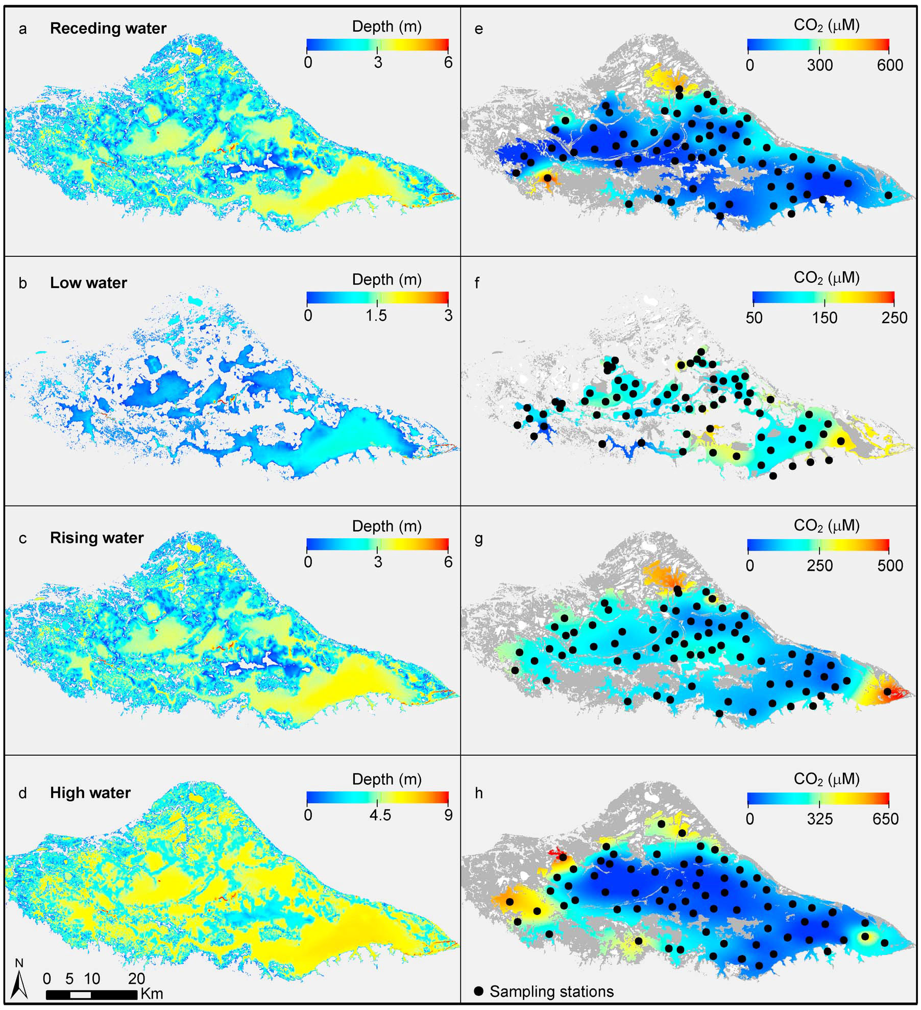
Figure 1. Lake bathymetry and spatial distribution of dissolved concentration of CO2 at (e) receding (Sep. 2003), (f) low (Nov. 2003), (g) rising (Feb. 2004), and (h) high water (Jun. 2004) for four hydrological phases. Sampling stations are indicated by black dots. Images are masked (gray) according to inundation extent. White regions are unsampled isolated lakes, and dark grey regions are represent flooded vegetation (Rudorff et al., 2011).
Data Citation:
Cite this data set as follows:
Barbosa, C.C.F., E.M.L.M. Novo, J.M. Melack and C.M. Rudorff. 2012. LBA-ECO LC-07 Water Quality, CO2, Chlorophyll, Lago Curuai, Para, Brazil: 2003-2004. Data set. Available on-line (http://daac.ornl.gov) from Oak Ridge National Laboratory Distributed Active Archive Center, Oak Ridge, Tennessee, U.S.A. http://dx.doi.org/10.3334/ORNLDAAC/1134
Implementation of the LBA Data and Publication Policy by Data Users:
The LBA Data and Publication Policy [http://daac.ornl.gov/LBA/lba_data_policy.html] is in effect for a period of five (5) years from the date of archiving and should be followed by data users who have obtained LBA data sets from the ORNL DAAC. Users who download LBA data in the five years after data have been archived must contact the investigators who collected the data, per provisions 6 and 7 in the Policy.
This data set was archived in October of 2012. Users who download the data between October 2012 and September 2017 must comply with the LBA Data and Publication Policy.
Data users should use the Investigator contact information in this document to communicate with the data provider. Alternatively, the LBA website [http://lba.inpa.gov.br/lba/] in Brazil will have current contact information.
Data users should use the Data Set Citation and other applicable references provided in this document to acknowledge use of the data.
Table of Contents:
- 1 Data Set Overview
- 2 Data Characteristics
- 3 Applications and Derivation
- 4 Quality Assessment
- 5 Acquisition Materials and Methods
- 6 Data Access
- 7 References
1. Data Set Overview:
Project: LBA (Large-Scale Biosphere-Atmosphere Experiment in the Amazon)
Activity: LBA-ECO
LBA Science Component: Land Use and Land Cover
Team ID: LC-07 (Melack / Novo / Forsberg)
The investigators were Forsberg, Bruce R; Melack, John M. Novo, Evlyn; Affonso, Adriana Gomes; Albuquerque, Paulo C Gurgel; Alcantara, Enner Herenio; Alsdorf, Douglas; Arruda, Warey de Costa; Barbosa, Claudio; Belger, Lauren ; Carvalho, Joao Carlos; Castellari, Sueli Pissarra; Correa, Denival Silva ; Correia, Antonio; Costa, Maycira; da Costa Freitas, Corina; Dutra, Luciano Vieira; Elmiro, Marcos Timbo; Filho, Waterloo Pereira; Franca, Andreia Maria Silva; Freitas, Ramon Morais; Frickmann, Fernando Cruz; Gama, Fabio Furlan; Gastil-Buhl, Mary ; Goncalves, Fabio Guimaraes; Hess, Laura Lorraine; Jardim-Lima, Dayson Jose; Kemenes, Alexandre; Kilham, Nina ; Kramer, Marc Gerald; Lima, Ivan Bergier Tavares de; Londe, Luciana de Resende; Marshall, Bruce Gavin; Mertes, Leal ; Mura, Jose Claudio; Rudorff, Conrado de Moraes; Sant'Anna, Sidnei J.S; Santos, Claudia Cristina dos; Santos, Joao Roberto dos; Shimabukuro, Yosio Edemir; Silva, Claudio Roberto; Silva, Thiago Sanna Freire; Titoneli, Fernanda and Vasconcelos, Cintia Honorio. You may contact Novo, Evlyn (evlyn@ltid.inpe.br).
LBA Data Set Inventory ID: LC07_Curuai_chl
This data set reports (1) concentrations of total, organic and inorganic suspended solids, dissolved inorganic and organic carbon, chlorophyll-a and (2) measurements of turbidity, ph, temperature, transparency, conductivity, and calculated carbon dioxide (CO2) in water samples collected from Lago Curuai (Lake Curuai), in the floodplain of the Amazon River south of Obidos, Para, Brazil. Approximately 70 stations were sampled during four phases of the hydrological cycle: receding (September 2003), low (November 2003), rising (February 2004), and high water (June 2004).
Related data sets
- LBA-ECO LC-07 Amazon Floodplain Lake Chlorophyll from MODIS, Para, Brazil: 2002-2003 (Chlorophyll concentration maps for the same study area and time period based on MODIS images)
- LBA-ECO LC-07 Bathymetric Survey of Floodplain Lake, Lago Curuai, Para, Brazil: 2004 (Water depth of Lago Curuai)
2. Data Characteristics:
Data are available in one ASCII comma-delimited file:
Field_measurements_Lago_Curuai.csv
| Column | Heading | Units/format | Description |
|---|---|---|---|
| 1 | Date | YYYYMMDD | Sampling date |
| 2 | Time | HH:MM | Sampling time in local time (local time is UTC-3) |
| 3 | Longitude | decimal degrees | Longitude of sampling location |
| 4 | Latitude | decimal degrees | Latitude of sampling location |
| 5 | TSS | mg/L | Concentration of total suspended solids reported in milligrams per liter (mg/L) and determined in samples filtered using Whatman GF/C 47mm circles |
| 6 | ISS | mg/L | Concentration of inorganic suspended solids reported in milligrams per liter (mg/L) and determined by ignition of organic suspended solids at 480 deg. Celsius |
| 7 | OSS | mg/L | Concentration of organic suspended solids reported in milligrams per liter (mg/L) and calculated as the difference between measured total suspended solids and inorganic suspended solids |
| 8 | Chlorophyll_a | ug/L | Chlorophyll-a concentration reported in micrograms per liter (ug/L) and determined spectrophotometrically; samples filtered using Whatman GF/F 47 mm circles |
| 9 | DIC | mg/L | Dissolved inorganic carbon concentration reported in milligrams per liter (mg/L) and determined using a Shimadzu TOC 5000A carbon analyzer calibrated with potassium biphthalate |
| 10 | DOC | mg/L | Dissolved organic carbon reported in milligrams per liter (mg/L) and determined using a Shimadzu TOC 5000A carbon analyzer calibrated with potassium biphthalate |
| 11 | Transparency | m | Transparency reported as Secchi depth in meters (m) and measured using a 20 cm diameter Secchi disk |
| 12 | Turbidity | NTU | Turbidity reported in nephelometric turbidity units (NTU) and measured using Horiba U-10 |
| 13 | Temperature | degrees C | Temperature reported in degrees Celsius and measured using Horiba U-10 |
| 14 | pH | pH measured using Horiba U-10 | |
| 15 | Conductivity | mS/cm | Conductivity reported in millisiemens per centimeter (mS/cm) and measured using Horiba U-10 |
| 16 | CO2 | umol CO2/L | Carbon dioxide concentration reported in micromoles of carbon dioxide per liter (umol CO2/L) calculated from pH, dissolved inorganic carbon, temperature, and conductivity as described in Rudorff et al. (2011) |
| In September 2003 water was collected with a cylindrical sampler which integrated the water column from surface to the Secchi depth. | |||
| In November 2003 and February 2004, samples were collected at subsurface (approximately 0.4 m below the surface). | |||
| In June 2004 samples were taken at 0.5 m below the surface. | |||
| Missing data are represented by -9999 | |||
Example data records
| Date,Time,Longitude,Latitude,TSS,ISS,OSS,Chlorophyll_a,DIC,DOC,Transparency,Turbidity,Temperature,pH,Conductivity,CO2
20030925,10:25,-55.789501,-2.20678,35.343,28.25,7.093,24.4064,17.45,18.82,0.3,123,32.5,6.45,21,607.95 20030925,12:07,-55.852402,-2.19675,94.62,59.347,35.273,205.797,4.764,9.242,0.12,205,34.7,8.37,25,3.29 20030925,12:30,-55.823399,-2.17569,49.888,40.14,9.748,47.7484,11.37,8.796,0.2,161,34.5,8.27,33,9.89 ... 20031129,10:20,-55.464401,-2.20558,436.21,369.53,66.68,34.7107,5.2,7.103,0.07,701,31,6.3,36,219.12 20031129,11:04,-55.511398,-2.21661,552.94,468.69,84.25,31.2034,3.793,7.05,0.06,838,31.2,6.4,34,141.5 20031129,11:44,-55.519001,-2.25131,593.06,494.46,98.6,27.696,2.597,6.104,0.07,808,32,6.1,24,133.73 ... 20040619,14:10,-55.1558,-2.22706,11.7656,7.02,4.74556,12.947,14.73,6.393,0.6,27,29.3,6.5,35,486.68 20040619,14:30,-55.1987,-2.23428,15.7943,5.33714,10.4571,57.017,11.92,11.73,0.65,27,29.7,8.42,30,7.66 20040619,15:12,-55.0909,-2.19436,67.446,58.686,8.76,0.67,13.3,10.17,0.25,127,28.2,6.53,31,424.75 |
Site boundaries: (All latitude and longitude given in decimal degrees)
| Site (Region) | Westernmost Longitude | Easternmost Longitude | Northernmost Latitude | Southernmost Latitude | Geodetic Datum |
|---|---|---|---|---|---|
| Lago Curuai (Amazonas (Manaus)) | -55.83472 | -55.02083 | -1.82056 | -2.33889 | South-American Datum, 1969 (SAD-69) |
Time period:
- The data set covers the period 2003/09/25 to 2004/06/30.
- Temporal Resolution: Samples were collected in four campaigns to cover the seasonal patterns in lake composition and depth
Platform/Sensor/Parameters measured include:
- LABORATORY/ SPECTROPHOTOMETER / CHLOROPHYLL
- FIELD INVESTIGATION / CONDUCTIVITY METERS / CONDUCTIVITY
- FIELD INVESTIGATION / PH METER / pH
- FIELD INVESTIGATION / TURBIDITY METERS / TURBIDITY
- LABORATORY / WEIGHING BALANCE / SUSPENDED SOLIDS
- LABORATORY / WEIGHING BALANCE / DISSOLVED SOLIDS
- LABORATORY / ANALYSIS / CARBON DIOXIDE
3. Data Application and Derivation:
These field measured values can be used to validate remote sensing methods of measuring chlorophyll concentrations (a proxy for productivity).
4. Quality Assessment:
Accuracy for chlorophyll-a lab analysis was 0.1 ug/L.
Accuracy for determination of total suspended solids and inorganic suspended solids was 0.005 mg/L. Organic suspended solids concentration was calculated as the difference between total suspended solids and inorganic suspended solids. Field and lab manipulations may change DIC concentration of water samples slightly.
Specifications of parameters measured with a routinely calibrated Horiba U-10 water quality meter:
- pH: Glass electrode, resolution: 0.01 pH units, repeatability: 0.05 pH units, temperature compensation: 0-50 degrees C.
- Conductivity: Alternating four-electrode, resolution: for the range of 0 to1 uS/cm, 0.01 uS/cm, for the range of 1 to 10 uS/cm, 0.1 uS/cm, and for the range of 10 to 100 uS/cm, 1.0 uS/cm, repeatability: plus or minus 1 percent of full scale, temperature compensation: 0-50 degrees C.
- Turbidity: Scattering/transmitting light, resolution: 1 NTU, repeatability: plus or minus 3 percent of full scale, temperature compensation: N/A.
- Temperature: Thermister, resolution: 0.1 degree C, repeatability: plus or minus 0.3 degrees C, temperature compensation: N/A.
5. Data Acquisition Materials and Methods:
Study site:
Lago Grande Curuai (Lake Curuai) lies in the floodplain of the Amazon River to the south of Obidos, Para, Brazil. It is composed of several interconnected lakes temporarily or permanently connected to the Amazon River by channels and overbank flow. The lake receives different types of water, i.e., white water from the Amazon River during the overflow stage and black and clear water from the local catchments during the low stage (Barbosa 2005).The stage of the Amazon River varies ca. 6 m annually in the nearby reach with a peak in June and minimum in November. The lake's flooded area ranges from about 850 to 2,274 square kilometers; at flood peak, open-water covers about 65 percent of the flooded area, with flooded vegetation covering the remaining area.
Water movements and mixing in Lake Curuai are complex, and the effects of physical forces (e.g., wind, solar radiation, river inflows) are modified by the lake's surface area and depth, varying seasonally and spatially. During low water the lake becomes sufficiently shallow for sediments to be re-suspended by wind-induced turbulence.
Sampling methods:
Four campaigns were conducted to sample limnological parameters during the four phases of inundation: receding (September 2003), low (November 2003), rising (February 2004), and high water (June 2004). Sampling stations were distributed in a dispersed spatial pattern (P < 0.01; based on the average nearest neighbor Euclidean distance test) over the main open-water region with an average nearest-neighbor distance of 3 km. Samples were collected between 9:00 and 15:00 (local time) over periods of 10 to 16 days.
In September 2003, water was collected with a cylindrical sampler which integrated the water column from the surface to the Secchi depth measured at the sampling location. In November 2003 and February 2004, lake depth and Secchi depth were low, and samples were collected at about 0.4 m below the surface. In June 2004, samples were collected at 0.5 m below the surface.
Field Measurements
Transparency was measured using a 20 cm diameter Secchi disk.
Temperature (accuracy of plus or minus 0.3 degrees C), conductivity (accuracy of plus or minus 1 percent), and pH (accuracy of plus or minus 0.05) were measured with routinely calibrated Horiba water quality sensors.
Carbon dioxide concentrations, in umol CO2/L, were calculated from pH, DIC, temperature, and conductivity as described in Rudorff et al. (2011).
Laboratory Analyses
Chlorophyll-a:
- Water samples were filtered through Whatman GF/F filters wrapped in aluminium foil and stored frozen (-20 degrees C) until the analysis was completed (up to 2 weeks later). Chlorophyll determination was performed according to Nush (1980).
- Filters were extracted with 80 percent ethanol at 75 degrees C for 5 min followed by submersions of the tubes in water near freezing. The extracts were kept in the refrigerator for 6 to 24 hours (h) before spectrophotometric determination.
Suspended Particles:
- Total suspended matter was determined on a known volume of lake water filtered through a GF/C filter pre-ashed at 480 degrees C and preweighed. Filters were stored in desiccators over silica gel. In the laboratory, the filter was dried at 60 degrees C for 24 h and weighed to determine total suspended matter.
- Suspended inorganic particles were determined on the same filter by ashing at 480 degrees C for 1 h and reweighing to determine inorganic particle concentration based on Wetzel and Likens (1991).
Dissolved constituents:
- For total dissolved carbon and DIC determination, lake water was passed through a pre-ashed Whatman GFC filter, and the filtrate was collected in 15 ml flasks and preserved with HCl.
- Samples were run in a combustion/nondispersive infrared gas analyzer (Shimadzu TOC 5000A) calibrated with potassium biphthalate according to APHA (1998).
- DOC was determined by difference the between total carbon and DIC.
6. Data Access:
This data is available through the Oak Ridge National Laboratory (ORNL) Distributed Active Archive Center (DAAC).
Data Archive Center:
Contact for Data Center Access Information:
E-mail:
uso@daac.ornl.gov
Telephone: +1 (865) 241-3952
References
APHA (1998) Standard methods for the examination of water and wastewater, 20th edn. American Public Health Association, Washington, D.C.
Barbosa CCF (2005) Sensoriamento remoto da dinâmica de circulação da água do sistema planície de Curuaí/Rio Amazonas. PhD thesis.
Kirk JTO (1994) Light and photosynthesis in aquatic ecosystems, 2nd edn. Cambridge University Press, Cambridge.
Nush EA (1980) Comparison of different methods for chlorophyll and phaeopigment determination. Arch Hydrobiol 4:14-36.
Rudorff, C.M., J.M. Melack, S. MacIntyre, C.C.F. Barbosa, and E.M.L.M. Novo (2011), Seasonal and spatial variability of CO2 emission from a large floodplain lake in the lower Amazon, J. Geophys. Res., 116, G04007, doi:10.1029/2011JG001699.
Sippel SJ, Hamilton SK, Melack JM (1992) Inundation area and morphometry of lakes on the Amazon River floodplain, Brazil. Arch Hydrobiol 123:385-400.
Wetzel RG, Likens GE (1991) Limnological analyses, 2nd edn. Springer, New York.
Related Publications
- Novo, E.M.L.M., C.C.F Barbosa, R.M. de Freitas, Y.E. Shimabukuro, J.M. Melack and W.P Filho. 2006. Seasonal changes in chlorophyll distributions in Amazon floodplain lakes derived from MODIS images. Limnology 7: 153-161.
- Barbosa, C.C.F.,E.M.L.M. Novo, J.M. Melack, M. Gastil-Buhl, W. Pereira Filho. 2010. Seasonal changes in chlorophyll distributions in Amazon floodplain lakes derived from MODIS images. Limnology 11:155-166. DOI 10.1007/s10201-009-0305-5