Get Data
Revision Date: August 7, 2014
Summary:
This data set provides diameter at breast height (DBH) measurements for 1,063 trees located at the Catuaba Experimental Farm, and 812 trees located in the Humaita Forest Reserve. Both sites are in the state of Acre, southwest Amazonia, Brazil. Measurements were made on individuals with DBH between 10 and 35 cm and individuals with DBH > 35 cm.
The Catuaba Experimental Farm is part of a forest fragment of approximately 800 ha. The Humaita Forest Reserve is located in a 1,500-ha forest band with dominant bamboo characteristic. Ten-ha areas were inventoried at both sites.
There is one data file in comma-delimited (.csv) format with this data set. There is also one companion data file with supplemental Catuaba site tree height and biomass data.
Data Citation:
Cite this data set as follows:
Selhorst, D., and I.F. Brown. 2014. LBA-ECO LC-02 Biophysical Measurements of Forests, Acre, Brazil: 1999-2002. Data set. Available on-line [http://daac.ornl.gov] from Oak Ridge National Laboratory Distributed Active Archive Center, Oak Ridge, Tennessee, USA. http://dx.doi.org/10.3334/ORNLDAAC/1237
Implementation of the LBA Data and Publication Policy by Data Users:
The LBA Data and Publication Policy [http://daac.ornl.gov/LBA/lba_data_policy.html] is in effect for a period of five (5) years from the date of archiving and should be followed by data users who have obtained LBA data sets from the ORNL DAAC. Users who download LBA data in the five years after data have been archived must contact the investigators who collected the data, per provisions 6 and 7 in the Policy.
This data set was archived in August 2014. Users who download the data between August 2014 and September 2019 must comply with the LBA Data and Publication Policy.
Data users should use the Investigator contact information in this document to communicate with the data provider.
Data users should use the Data Set Citation and other applicable references provided in this document to acknowledge use of the data.
Table of Contents:
- 1 Data Set Overview
- 2 Data Characteristics
- 3 Applications and Derivation
- 4 Quality Assessment
- 5 Acquisition Materials and Methods
- 6 Data Access
- 7 References
1. Data Set Overview:
Project: LBA (Large-Scale Biosphere-Atmosphere Experiment in the Amazon)
Activity: LBA-ECO
LBA Science Component: Land Use and Land Cover
Team ID: LC-02 (Brown / Silveira / Esteves)
The investigators were Brown, Irving Foster; Silveira, Marcos; Camargo, Plinio Barbosa de; Mauricio, Paulo Henrique da Silva; Selhorst, Diogo; Trumbore, Susan E. and Vieira, Simone Aparecida .You may contact Selhorst, Diogo (dselhorst@pop.com.br)
LBA Data Set Inventory ID: LC02_PermPlot_Acre
This data set provides diameter at breast height (DBH) measurements for 1,063 trees located at the Catuaba Experimental Farm, and 812 trees located in the Humaita Forest Reserve. Both sites are in the state of Acre, southwest Amazonia, Brazil. Measurements were made on individuals with DBH between 10 and 35 cm and individuals with DBH > 35 cm.
The Catuaba Experimental Farm is part of a forest fragment of approximately 800 ha. The Humaita Forest Reserve is located in a 1,500-ha forest band with dominant bamboo characteristic. Ten-ha areas were inventoried at both sites.
Related data sets:
- LBA-ECO LC-02 Groundwater Levels, Catuaba Experimental Farm, Acre, Brazil: 1999-2004 (Study performed at the same area during same time period)
- LBA-ECO CD-08 Radiocarbon Dating of Tree Ages in Amazonas, Acre, and Para in Brazil (Study performed at the same area during same time period)
2. Data Characteristics:
There is one comma-delimited data file (.csv) with this data set. Measurements were made twice at the Catuaba site between November 1999 and July 2002, and one time at the Humaita site between January 2003 and April 2004.
File #1. LC02_Catuaba_Humaita_10ha_inventories.csv
| Column | Column Heading | Units/format | Description |
|---|---|---|---|
| 1 | Site | Sampling location: Catauba or Humaita | |
| 2 | Index | ||
| 3 | Tree_tag | Unique id tag number for each tree within a site | |
| 4 | Sub-plot | Sampling subplot 25 x 25-m area | |
| 5 | Date_first_inv | yyyy-yyyy | Sampling date for the first inventory at Catuaba occurred between Nov. 1999 and July 2000 and at Humaita between January 2003 and March 2004 |
| 6 | Date_second_inv | yyyy-yyyy | Sampling date for the second inventory at Catuaba between Sept. 2001 and Sept. 2002. There was no second inventory at Humaita |
| 7 | Status_first_inv | Status in first inventory either live or dead | |
| 8 | Diameter_class | cm | 1= greater than 35 cm diameter: 2= greater than or equal to 10 and less than or equal to 35 cm diameter: 3 recruited into the smaller diameter class in the second inventory; 4 recruited into the larger diameter class in the second inventory |
| 9 | DBH_first_inv | cm | Diameter at breast height in centimeters (cm) measured at the first inventory |
| 10 | DBH_second_inv | cm | Diameter at breast height in centimeters (cm) measured at the second inventory |
| 11 | DBH_height | m | Actual height of DBH measurement if different from 1.3 m |
| 12 | X | m | Distance in meters (m) from plot origin (Southwest corner) on the x axis (East-West) |
| 13 | Y | m | Distance in meters (m) from plot origin (Southwest corner) on the y axis (North-South) |
| 14 | Common_name | Common name assigned by Sr. Raimundo of the Fundaçāo De Tecnología Do Acre (FUNTAC) | |
| 15 | Scientific_name | Scientific name | |
| 16 | Observations | comments from the field notebook | |
| Missing data are represented as -9999 | |||
Note: There is also a companion file in comma-delimited format (.csv) provided with this data set, LC02_Catauba_biomass_height.csv. The file provides DBH, height, and calculated biomass estimates for most of the trees at the Catuaba site. For most of the tree records (Tree_tag), the values for X, Y, DBH, and Common_name are identical to X, Y, DBH_first_inv, and Common_name values in the data file LC02_Catuaba_Humaita_10ha_inventories.csv. However, there are some differences and these differences could not be resolved. Consequently, we are providing the tree height and biomass data in the companion file and leaving it up to users to compare and selected tree height and biomass data as needed.
Site boundaries: (All latitude and longitude given in decimal degrees)
| Site (Region) | Westernmost Longitude | Easternmost Longitude | Northernmost Latitude | Southernmost Latitude | Geodetic Datum |
|---|---|---|---|---|---|
| Acre - Catuaba Experimental Farm (Acre) | -67.629 | - 67.629 | -10.073 | - 10.073 | World Geodetic System, 1984 (WGS-84) |
| Humaita Forest Reserve (Acre) | -67 | - 67 | -7 | - 7 | World Geodetic System, 1984 (WGS-84) |
Time period:
- The data set covers the period 1999/11/01 to 2004/04/30
- Temporal Resolution: At the Catauba site, two surveys-- the first between Nov. 1999 and July 2000 and the second between Sept. 2001 and Sept. 2002. There was one survey at the Humaita site between January 2003 and April 2004.
Platform/Sensor/Parameters measured include:
- COMPUTER MODEL / ANALYSIS / BIOMASS
- FIELD INVESTIGATION / STEEL MEASURING TAPE / FOREST
3. Data Application and Derivation:
Living trees constitute a major carbon pool in tropical forests (Vieira et al., 2004). A better understanding of the variations in structure and dynamics of these forests is necessary to better predict the ability of these systems to respond to disturbance and their potential to act as either a sink or a source of carbon in the future. In combination with similar data from other sites across the Amazon basin, these data contribute to a better understanding of the role of seasonality, disturbance and diversity in regulating carbon allocation and productivity.
4. Quality Assessment:
Diameter measurements were done with steel tapes with an error or plus or minus 0.2 cm. Data have been reviewed and there are no known problems with them.
5. Data Acquisition Materials and Methods:
The Catuaba Experimental Farm is a Federal University of Acre property in the east of Acre State. The farm is part of a forest fragment which covers approximately 1,500 ha with open forest mixed with bamboo the dominant forest type. Soils are Oxisols at the permanent plots (latossolo vermelho amarelo distrofico in the Brazilian classification system) (Vieira et al., 2004). The Humaita Forest Reserve is located in a 1,500 ha forest band with dominant bamboo characteristic.
Field methods:
Ten ha (200 x 500 meters) permanent study plots were established by the Sector for Studies of Land Use Change, Federal University of Acre (SETEM-UFAC) in 1999. All stems greater than 35-cm diameter DBH (DBH measured at 1.3 m above the ground unless otherwise noted) were tagged, mapped, and measured. Trees with DBH between 10 and 35 cm were measured, mapped, and tagged in 16 sub-plots (25 x 25-m area for a total sampling area of 1 ha) (Vieira et al., 2004).
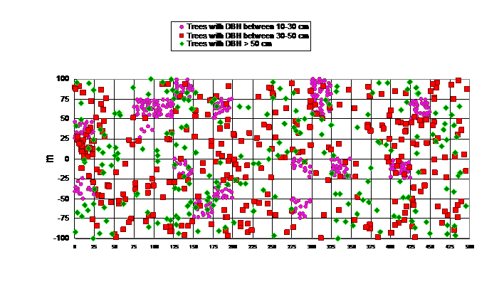
Figure 1. Locations of trees at the Catuaba site on the X-Y grid. Y values can be negative.
Biomass estimates in the companion file:
The allometric equation below developed by Chambers et al. (2001) for the central Amazon was used to estimate
total aboveground biomass (TAGB) increase from diameter (DBH):
ln (TAGB)=α+β1 ln(DBH)
+β2
[ln(DBH)]2
+β3 [ln(DBH)]3
where: α= −0.370; β1=0.333; β2=0.933; and β3=−0.122.
6. Data Access:
These data are available through the Oak Ridge National Laboratory (ORNL) Distributed Active Archive Center (DAAC).
Data Archive Center:
Contact for Data Center Access Information:
E-mail: uso@daac.ornl.gov
Telephone: +1 (865) 241-3952
7. References:
Chambers JQ, Santos J, Ribeiro RJ, Higuchi N (2001). Tree damage, allometric relationships, and above-ground net primary production in central Amazon forest. For Ecol Manage 152:73–84
Vieira, S., P.B. de Camargo, D. Selhorst, R. Da Silva, L. Hutyra, J.Q. Chambers, I.F. Brown, N. Higuchi, J. dos Santos, S.C. Wofsy, S.E. Trumbore, and L.A. Martinelli. (2004). Forest structure and carbon dynamics in Amazonian tropical rain forests. Oecologia (2004) 140: 468–479 DOI 10.1007/s00442-004-1598-z