Get Data
Revision date: May 5, 2012
Summary:
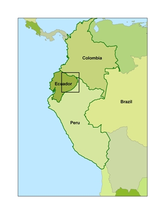
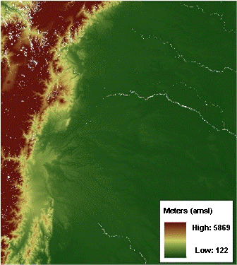
This data set provides 90-meter resolution Digital Elevation Model data used in the University of North Carolina's Carolina Population Center (CPC) Ecuador Projects. The topographic data were derived from Shuttle Radar Topography Mission (SRTM) C-band and X-band interferometric synthetic aperture radars (IFSARs) data that were acquired over 80% of Earth's land mass in February 2000. This data set includes one image in GeoTiff format that is a subset for the Northern Ecuadorian Amazon region.


Figure 1. Northern Ecuadorian Amazon subset of the 90-meter Digital Elevation Model data.
Data Citation:
Cite this data set as follows:
Bilsborrow, R.E., S.J. Walsh and B. Frizzelle. 2012. LBA-ECO LC-01 SRTM 90-Meter Digital Elevation Model, Northern Ecuadorian Amazon. Data set. Available on-line [http://daac.ornl.gov] from Oak Ridge National Laboratory Distributed Active Archive Center, Oak Ridge, Tennessee, U.S.A. http://dx.doi.org/10.3334/ORNLDAAC/1083
Implementation of the LBA Data and Publication Policy by Data Users:
The LBA Data and Publication Policy [http://daac.ornl.gov/LBA/lba_data_policy.html] is in effect for a period of five (5) years from the date of archiving and should be followed by data users who have obtained LBA data sets from the ORNL DAAC. Users who download LBA data in the five years after data have been archived must contact the investigators who collected the data, per provisions 6 and 7 in the Policy.
This data set was archived in May of 2012. Users who download the data between May 2012 and April 2017 must comply with the LBA Data and Publication Policy.
Data users should use the Investigator contact information in this document to communicate with the data provider. Alternatively, the LBA website [http://lba.inpa.gov.br/lba/] in Brazil will have current contact information.
Data users should use the Data Set Citation and other applicable references provided in this document to acknowledge use of the data.
Table of Contents:
- 1 Data Set Overview
- 2 Data Characteristics
- 3 Applications and Derivation
- 4 Quality Assessment
- 5 Acquisition Materials and Methods
- 6 Data Access
- 7 References
1. Data Set Overview:
Project: LBA (Large-Scale Biosphere-Atmosphere Experiment in the Amazon)
Activity: LBA-ECO
LBA Science Component: Land Use and Land Cover
Team ID: LC-01 (Walsh / Bilsborrow / Ruiz)
The investigators were Bilsborrow, Richard E.; Walsh, Stephen J.; Ruiz, Alicia; Baquero, Francis; Barbieri, Alisson Flavio; Boschini, Laura Patricia; Bremner, Jason Lee; Erlien, Christine; Frizzelle, Brian; Gray, Clark; Mena, Carlos; Messina, Joseph P. and Pan, William. You may contact Walsh, Stephen J. (swalsh@email.unc.edu).
LBA Data Set Inventory ID: LC01_SRTM_DEM_90m
This data set provides 90-meter resolution Digital Elevation Model data used in the University of North Carolina's Carolina Population Center (CPC) Ecuador Projects. The topographic data were derived from Shuttle Radar Topography Mission (SRTM) C-band and X-band interferometric synthetic aperture radars (IFSARs) data that were acquired over 80% of Earth's land mass in February 2000. This data set includes one image in GeoTiff format that is a subset for the Northern Ecuadorian Amazon region.
Related data sets (data from studies conducted in same region):
- LBA-ECO LC-01 City, Community, and Road Maps, Northern Ecuadorian Amazon: 1990-2002
- LBA-ECO LC-01 Hydrography, Morphology, Edaphology Maps, Northern Ecuadorian Amazon
- LBA-ECO LC-01 National, Provincial, and Park Boundaries, Ecuador
- LBA-ECO LC-01 Northern Ecuadorian Amazon Household Surveys, Summary Results: 1999
- LBA-ECO LC-01 Topographic Data for Intensive Study Areas, Northern Ecuadorian Amazon
- LBA-ECO LC-01 Landsat TM Land Use/Land Cover, Northern Ecuadorian Amazon: 1986-1999
2. Data Characteristics:
There is one GeoTiff at 90-meter resolution with this data set.
The image has the projection parameters listed below:
- Projected Coordinate System: WGS_1984_UTM_Zone_18S
- Projection: Transverse_Mercator
- False_Easting: 500000.000000
- False_Northing: 10000000.000000
- Central_Meridian: -75.000000
- Scale_Factor: 0.999600
- Latitude_of_Origin: 0.000000
- Linear_Unit: Meter
- Geographic Coordinate System: GCS_WGS_1984
- Datum: D_WGS_1984
- Prime Meridian: Greenwich
- Angular Unit: Degree
Image Statistics
- Unit: meters
- Minimum: 122
- Maximum: 5869
- Mean: 822.640
- Standard. deviation: 1050.798
Site boundaries: (All latitude and longitude given in decimal degrees)
| Site (Region) | Westernmost Longitude | Easternmost Longitude | Northernmost Latitude | Southernmost Latitude | Geodetic Datum |
|---|---|---|---|---|---|
| Northern Ecuadorian Amazon (Ecuador) | -78.53417 | -75.036116 | 0.949869 | -2.981183 | World Geodetic System, 1984 (WGS-84) |
Time period:
- The data set covers the period: 2000/02/11 to 2000/02/22
- Temporal Resolution: one time campaign
Platform/Sensor/Parameters measured include:
- SRTM (SHUTTLE RADAR TOPOGRAPHY MISSION) / SAR (SYNTHETIC APERTURE RADAR) / TERRAIN ELEVATION
3. Data Application and Derivation:
This data set may be used in studies requiring topographic data, climate studies (when combined with orographic data), or determination of surface water area and elevation.
4. Quality Assessment:
Accuracy report produced by Rodriguez et al. (2005) available at http://www2.jpl.nasa.gov/srtm/SRTM_paper.pdf
5. Data Acquisition Materials and Methods:
Site description
The Northeastern Ecuadorian
Amazon is significant from social, biophysical, and geographical bases,
with complex terrain and landuse/landchange variability. The western
Amazon region, bordering the Andes and lying at the headwaters of the
Amazon River basin, possesses several major centers of endemism,
including the Napo. Settlers in the Napo and Sucumbios provinces, the two dominant Cantons or States, settled on 50 ha plots, clearing primary forest to grow subsistence crops, coffee, and for pasturage. The annual precipitation is high
(2,800 mm/year), so there is no distinct dry season. Despite the region's global biodiversity and carbon sequestration significance, agricultural settlement and consequent deforestation threaten the region
(Messina and Walsh, 2001).
Data Acquisition
All tiles were acquired from U.S. Geological Survey (USGS).
The Shuttle Radar Topography Mission (SRTM) aboard the Space Shuttle Endeavor launched on Feb. 11, 2000, for an 11 day mission. SRTM used the same radar instrument that comprised the Spaceborne Imaging Radar-C/X-Band Synthetic Aperture Radar (SIR-C/X-SAR) that flew twice on the Space Shuttle Endeavor in 1994. SRTM was assigned to collect 3-D measurements of the Earth's surface. To collect the 3-D data, engineers added a 60-meter (approximately 200-foot) mast, installed additional C-band and X-band antennas, and improved tracking and navigation devices.
Topographic data was acquired from C-band and X-band interferometric synthetic aperture radars (IFSARs) over 80% of Earth's land mass (between 60 deg N and 56 deg S). The goal was to produce digital topographic map products that meet Interferometric Terrain Height Data (ITHD)-2 specifications (30 m x 30 m spatial sampling with <=16 m absolute vertical height accuracy, <= 10 m relative vertical height accuracy and <=20 m absolute horizontal circular accuracy). All accuracies are quoted at the 90% level, consistent with National Map Accuracy Standards.
6. Data Access:
This data is available through the Oak Ridge National Laboratory (ORNL) Distributed Active Archive Center (DAAC).
Data Archive Center:
Contact for Data Center Access Information:
E-mail: uso@daac.ornl.gov
Telephone: +1 (865) 241-3952
7. References:
Messina, J.P. and S.J. Walsh. 2001. 2.5D Morphogenesis: Modeling Landuse and Landcover Dynamics in the Ecuadorian Amazon. Plant Ecology, 156 (1): 75-88.
Rodriguez, E., C.S. Morris, J.E. Belz, E.C. Chapin, J.M. Martin, W. Daffer, S. Hensley, 2005, An assessment of the SRTM topographic products, Technical Report JPL D-31639, Jet Propulsion Laboratory, Pasadena, California, 143 pp.