Get Data
Summary:
This data set provides high-resolution (~500 m) gridded land and stream drainage direction maps for the Amazon River Basin, excluding the Rio Tocantins Basin. These maps are the result of a new topography-independent analysis method (Mayorga et al., 2005) using the vector river network from the Digital Chart of the World (DCW, Danko, 1992) to create a high-resolution flow direction map.
The data products include (1) a stream network coverage with stream order assigned to each reach; (2) the basin boundaries of the major tributaries to the Amazon mainstem; (3) the mouths; and (4) the source points of these tributaries.
There are 7 ESRI ArcGIS shapefiles provided in compressed *.zip format and 4 GeoTiff image files with this data set.
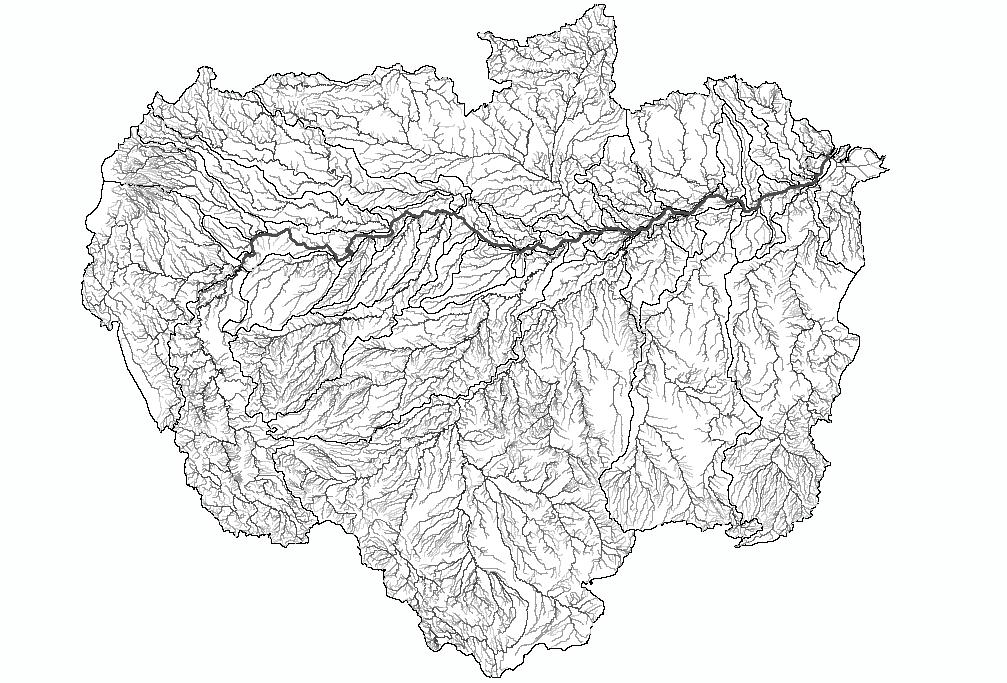
Figure 1. Basin boundaries, stream network and Amazon mainstem.
Data Citation:
Cite this data set as follows:
Mayorga, E., M.G. Logsdon, M.V.R. Ballester, and J.E. Richey. 2012. LBA-ECO CD-06 Amazon River Basin Land and Stream Drainage Direction Maps. Data set. Available on-line [http://daac.ornl.gov] from Oak Ridge National Laboratory Distributed Active Archive Center, Oak Ridge, Tennessee, U.S.A. http://dx.doi.org/10.3334/ORNLDAAC/1086
Implementation of the LBA Data and Publication Policy by Data Users:
The LBA Data and Publication Policy [http://daac.ornl.gov/LBA/lba_data_policy.html] is in effect for a period of five (5) years from the date of archiving and should be followed by data users who have obtained LBA data sets from the ORNL DAAC. Users who download LBA data in the five years after data have been archived must contact the investigators who collected the data, per provisions 6 and 7 in the Policy.
This data set was archived in May of 2012. Users who download the data between May 2012 and April 2017 must comply with the LBA Data and Publication Policy.
Data users should use the Investigator contact information in this document to communicate with the data provider. Alternatively, the LBA website [http://lba.inpa.gov.br/lba/] in Brazil will have current contact information.
Data users should use the Data Set Citation and other applicable references provided in this document to acknowledge use of the data.
Table of Contents:
- 1 Data Set Overview
- 2 Data Characteristics
- 3 Applications and Derivation
- 4 Quality Assessment
- 5 Acquisition Materials and Methods
- 6 Data Access
- 7 References
1. Data Set Overview:
Project: LBA (Large-Scale Biosphere-Atmosphere Experiment in the Amazon)
Activity: LBA-ECO
LBA Science Component: Land Surface Hydrology
Team ID: CD-06 (Richey / Victoria)
The investigators were Richey, Jeffrey E.; Victoria, Reynaldo Luiz; Aalto, Rolf Erhart; Abdo, Mara Silvia Aguiar; Alin, Simone Rebecca; Aufdenkampe, Anthony K.; Ballester, Maria Victoria Ramos; Barbosa, Roosevelt Passos; Bernardes, Marcelo Correa; Bolson, Marcos Alexandre; Bonelle, Nilton; Brito, David Silva; Cogo, Michelle Cristine; Cunha, Hillandia Brandao; Silva, Luis Vilmar Souza da; Deus, Fabiano Alves de; Devol, Allan H.; Ellis, Erin Elizabeth; Ferro, Jaderson Coradi; Filho, Walter Jorge do Nascimento; Frickmann, Fernando Cruz; Guandique, Manuel Enrique Gamero; Gomes, Beatriz M.; Neto, Sergio Candido Gouveia; Hanada, Lais de Carvalho; Holtgrieve, Gordon William; Krusche, Alex V.; Lacerda, Francisco A. Siebra; Leite, Nei Kavaguichi; Logsdon, Miles Grant; Macedo, Gelson de; Marcondes, Renata; McGeoch, Lauren; Melo, Emanuele Gurgel de Freitas; Mendes, Francisco de Assis; Moreira, Marcelo Zacharias; Neu, Vania; Oliveira, Carolina Barisson Marques; Ometto, Jean Pierre H.B.; Pimentel, Tania Pena; Filho, Nicolau Priante; Rasera, Maria de Fatima Fernandes Lamy; Remington, Sonya Marie; Rodda, Sarah; Salimon, Cleber Ibraim; Santiago, Alailson Venceslau; Santos, Arnoldo Marcilio dos; Silva, Cleoni Virginio da; Silva, Jonismar Souza; Silva, Simao Correa da; Souzapetro, Petronio Lopes de; Toledo, Andre Marcondes Andrade; Tumang, Cristiane Azevedo and Victoria, Daniel de Castro. You may contact Mayorga, Emilio (emiliom@u.washington.edu).
LBA Data Set Inventory ID: CD06_CAMREX
This data set provides high-resolution (~500 m) gridded land and stream drainage direction maps for the Amazon River Basin, excluding the Rio Tocantins Basin. These maps are the result of a new topography-independent analysis method (Mayorga et al., 2005) using the vector river network from the Digital Chart of the World (DCW, Danko, 1992) to create a high-resolution flow direction map. The data products include (1) a stream network coverage with stream order assigned to each reach; (2) the basin boundaries of the major tributaries to the Amazon mainstem; (3) the mouths; and (4) the source points of these tributaries.
2. Data Characteristics:
There are 11 data files with this data set: seven ESRI ArcGIS shapefiles provided as compressed *zip files, and four files provided as GeoTiffs.
GeoTiff files:
amzflowlen: Flow length grid, in km from the mouth of the Amazonamzflowdir: Flow direction grid (1-128, following the ARCINFO convention)
amzflowdir: Flow direction grid
amzflowacc: Flow accumulation grid
amzbasin: The amazon basin
File characteristics:
- Resolution: 0.005 degrees
- Geographic Coordinate System: GCS_Clarke_1866
- Datum: D_Clarke_1866
Shapefiles: There are 7 ESRI ArcGIS shapefiles in compressed*.zip format. When unzipped, each shapefile contains seven files (.dbf, .prj, .sbn, .sbx, . shp, .xml, .shx).
Projection parameters of the shapefiles:
- Geographic Coordinate System: GCS_Clarke_1866
- Semimajor Axis: 6378206.40000000000
- Semimajor Axis: 6378206.40000000000
- Semiminor Axis: 6356583.79999898090
- Inverse Flattening: 294.97869820000000
- Spheroid: Clarke_1866
- Datum: D_Clarke_1986
- Prime Meridian: Greenwich
- Angular Unit: Degree
Shapefile names and descriptions:
amzrivnet_v.xxx: Corrected version of the stream network in the Amazon basin from the Digital Chart of the World.
Attributes:
- FID: Internal feature number; sequential unique whole numbers that are automatically generated
- Shape: Feature geometry
- LENGTH: Length of feature in internal units
- AMZRIVNET: Internal feature number; sequential unique whole numbers that are automatically generated
- AMZRIVNET_1
amzmainstm_v.xxx: Amazonas mainstem proper -- that is, the river reach beginning at the confluence of the Ucayali and Maran rivers and ending at the mouth.
Attributes:
- FID: Internal feature number; sequential unique whole numbers that are automatically generated
- Shape: Feature geometry
- LENGTH: Length of feature in internal units
- AMZMAINSTM: Internal feature number; sequential unique whole numbers that are automatically generated
amzmouthpt_v.xxx: point shapefile representing the mouth of the Amazon River
Attributes:
- FID: Internal feature number; sequential unique whole numbers that are automatically generated
- Shape: Feature geometry
- AMZMOUTHPT: Internal feature number; sequential unique whole numbers that are automatically generated
amzstrmord_v.xxx: a line shapefile indicating stream orders.
Attributes:
- FID: Internal feature number; sequential unique whole numbers that are automatically generated
- Shape: Feature geometry
- LENGTH: Length of feature in internal units
- AMZSTRMOD: Internal feature number; sequential unique whole numbers that are automatically generated
- AMZSTRMOD_1: Stream order
amztrbmth_v.xxx: a point shapefile showing the mouth points of all the major tributaries in the Amazon basin.
Attributes:
- FID: Internal feature number; sequential unique whole numbers that are automatically generated
- Shape: Feature geometry
- AMZTRBMTH: Internal feature number; sequential unique whole numbers that are automatically generated
- BASINID: Corresponds to the BASINID number in the amztrbbas_v shapefile where the point is located
- X_COORD: x-coordinate:
- Y_COORD: y-coordinate
amztrbsrc_v.xxx: shapefile for each of the major tributaries (including the mainstem), corresponding to the maximum distance from the the source of that tributary.
Attributes:
- FID: Internal feature number; sequential unique whole numbers that are automatically generated
- Shape: Feature geometry
- AMZTRBSRC: Internal feature number; sequential unique whole numbers that are automatically generated where the point is located
- BASINID: Corresponds to the BASINID number in the amztrbbas_v shapefile where the point is located
amztrbbas_v.xxx: polygon shapefile showing each major tributary subbasin as well as the mainstem drainage area
Attributes:
- FID: Internal feature number; sequential unique whole numbers that are automatically generated
- Shape: Feature geometry
- AREA: Area of feature in internal units
- AMZTRBBAS: Internal feature number; sequential unique whole numbers that are automatically generated
Site boundaries: (All latitude and longitude given in decimal degrees)
| Site (Region) | Westernmost Longitude | Easternmost Longitude | Northernmost Latitude | Southernmost Latitude | Geodetic Datum |
|---|---|---|---|---|---|
| Amazon Basin (Amazon Basin) | -80.5 | -48.5 | 6 | -20.5 |
Time period:
- The data set covers the period 1940/01/01 to 1960/01/01.
- Temporal Resolution: Varies
Platform/Sensor/Parameters measured include:
- MAPS / DIGITIZER / RIVERS/STREAMS
- MAPS / DIGITIZER / DRAINAGE
- MAPS / DIGITIZER / RIVER NETWORK
3. Data Application and Derivation:
The data could be used in the CAMREX research group (Carbon in the Amazon River Experiment),
a project engaged in spatially distributed hydrological and biogeochemical modeling for the entire Amazon basin.
This single drainage data set provides a high-resolution basin-wide river network and an associated drainage direction map to facilitate water routing modeling and watershed boundary extraction.
The data can be used in spatially distributed hydrological and biogeochemical modeling for the entire Amazon basin
The methods developed derive space-filling gridded cell-to-cell surface flow paths from digital channel networks,
intended to be used in regions where existing Digital Elevation Models (DEMs) are inadequate but detailed channel network maps are available.
4. Quality Assessment:
Quality assessment information was not provided.
5. Data Acquisition Materials and Methods:
Site description
The Amazon River Basin is east of the Andes mountains and extends from the Guyana Plateau in the north to the Brazilian Plateau in the south. The Basin covers more than 6,100,000 km2 and has a varying climate and topography. The Amazon River has a discharge of approximately 210,000 m per second.
Methods
We developed a topography-independent method for creating gridded, land and stream drainage direction maps based on corrected vector river networks. The methods derive space-filling gridded cell-to-cell surface flow paths from digital channel networks, intended to be used in regions where existing Digital Elevation Models
(DEMs) are inadequate but detailed channel network maps are available. Required inputs include a vector or gridded representation of the river network, the mouth of the system,
and the corresponding basin boundary.
All data processing and algorithm implementation were carried out using a combination of custom C programs and ArcInfo software
(Mayorga et al., 2005). The goal of the algorithms was to create a basin-wide,
land and river flow direction grid. The input data sets were the gridded versions of the pre-processed
data sets on river network, basin, and mouth coordinates. Drainage
networks were checked utilizing GIS, air photography and atlases.
For convenience, the
network and basin are first combined into a single grid,
assigning different integer cell values or flags to each (Mayorga et al., 2005). The algorithm first assigns
cell-to-cell flow directions to each cell in the gridded river network using
shortest-distance criteria; it allocates each land cell to its nearest river network cell; and approximates a cell-to-cell flow path from each land cell to a river cell. With a complete land and river flow direction grid created, surface flow path analysis functions can be
applied in the same manner as with flow direction grids derived from DEMs.
This methodology was applied to the entire Amazon basin
for the CAMREX research group (Carbon in the
Amazon River Experiment) in order to provide a single drainage data set using a corrected version of the Digital Chart of the
World river network (DCW, Danko,1992) to create the high-resolution
basin-wide river network and drainage flow direction map.
6. Data Access:
This data is available through the Oak Ridge National Laboratory (ORNL) Distributed Active Archive Center (DAAC).
Data Archive Center:
Contact for Data Center Access Information:
E-mail: uso@daac.ornl.gov
Telephone: +1 (865) 241-3952
7. References:
Danko, D.M., 1992. The digital chart of the world. GeoInfo Systems 2, 29–36.
Mayorga, E., M.G. Logsdon, M.V.R. Ballester, and J.E. Richey. 2005. Estimating cell-to-cell land surface drainage paths from digital channel networks, with an application to the Amazon basin. Journal of Hydrology 315(1-4):167-182.