Get Data
Summary:
This data set contains the results of a biometric tree survey of a 19.25 ha area adjacent to the eddy flux tower at the km 83 logged forest tower site in Tapajos National Forest, Para, Brazil. The survey was done in March 2000. All measurements reported here were taken before the logging began. Diameters of all trees > 35 cm DBH within the 19.25 ha survey area were recorded and trees with DBH between 10 and 35 cm DBH were recorded along three transects with a total area of 2.3 ha (Miller et al., 2004). These data were used to calculate net ecosystem productivity (NEP) and the role of this forest as a carbon source or sink. Biometric data are reported in one comma-delimited ASCII file.
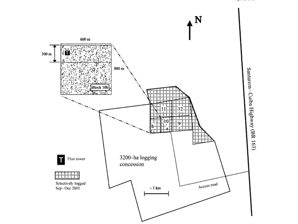
Figure 1. The shaded area denotes the 700 ha portion of the 3200 ha logging concession logged September through December 2001. The location of the eddy flux tower is denoted by the ‘‘T’’ in block 10b. The biometric tree survey area was east (upwind) of the eddy flux tower.
Data Citation:
Cite this data set as follows:
Menton, M., M. Figueira, C.A.D. de Sousa, S.D. Miller, H.R. da Rocha, and M.L. Goulden. 2011. LBA-ECO CD-04 Biomass Survey, km 83 Tower Site, Tapajos National Forest, Brazil. Data set. Available on-line [http://daac.ornl.gov] from Oak Ridge National Laboratory Distributed Active Archive Center, Oak Ridge, Tennessee, U.S.A. doi:10.3334/ORNLDAAC/990
Implementation of the LBA Data and Publication Policy by Data Users:
The LBA Data and Publication Policy [http://daac.ornl.gov/LBA/lba_data_policy.html] is in effect for a period of five (5) years from the date of archiving and should be followed by data users who have obtained LBA data sets from the ORNL DAAC. Users who download LBA data in the five years after data have been archived must contact the investigators who collected the data, per provisions 6 and 7 in the Policy.
This data set was archived in January of 2011. Users who download the data between January 2011 and December 2015 must comply with the LBA Data and Publication Policy.
Data users should use the Investigator contact information in this document to communicate with the data provider. Alternatively, the LBA Web Site [http://lba.inpa.gov.br/lba/] in Brazil will have current contact information.
Data users should use the Data Set Citation and other applicable references provided in this document to acknowledge use of the data.
Table of Contents:
- 1 Data Set Overview
- 2 Data Characteristics
- 3 Applications and Derivation
- 4 Quality Assessment
- 5 Acquisition Materials and Methods
- 6 Data Access
- 7 References
1. Data Set Overview:
Project: LBA (Large-Scale Biosphere-Atmosphere Experiment in the Amazon)
Activity: LBA-ECO
LBA Science Component: Carbon Dynamics
Team ID: CD-04 (Goulden / Rocha)
The investigators were Goulden, Prof. Michael L.; Menton, Mary Catherine; Miller, Dr. Scott Dennis; Rocha, Prof. Humberto Ribeiro da; Freitas, Helber Custodio de; Figuera, Michela and Cleilim Albert Sousa . You may contact Miller, Dr. Scott Dennis (sdmiller@uci.edu )
LBA Data Set Inventory ID: CD04_Biomass
This data set contains the results of a biometric tree survey of a 19.25 ha area adjacent to the eddy flux tower at the km 83 logged tower site in Tapajos National Forest, Para, Brazil. The survey was done in March 2000. All measurements reported here were taken before the logging began. Diameters of all trees > 35 cm DBH within the 19.25 ha survey area were recorded and trees with DBH between 10 and 35 cm DBH were recorded along three transects with a total area of 2.3 ha (Miller et al., 2004). These data were used to calculate net ecosystem productivity (NEP) and the role of this forest as a carbon source or sink. Biometric data are reported in one comma-delimited ASCII file.
Related Data Sets
- LBA-ECO CD-04 Leaf Litter Data, km 83 Tower Site, Tapajos National Forest, Brazil (Litter productivity from the same collections)
- LBA-ECO CD-04 Leaf Area Index, km 83 Tower Site, Tapajos National Forest, Brazil (LAI from the same site calculated using a different method)
- LBA-ECO CD-04 Dendrometry, km 83 Tower Site, Tapajos National Forest, Brazil (Dendrometry study at the same site)
2. Data Characteristics:
Data are presented in one comma separated ASCII file: CD04_TNF_KM83_Tree_Survey_2000.csv
| Column | Heading | Units/format | Description |
|---|---|---|---|
| 1 | COMMON NAME | tree common name | |
| 2 | SCIENTIFIC NAME | tree scientific name | |
| 3 | FAMILY | tree family | |
| 4 | BLOCK | location within the 18 ha grid where damaged tree was located | |
| 5 | TAG # | LBA tag number installed 2000 | |
| 6 | DBH | cm | diameter at breast height (DBH) |
| Missing data are represented by -999 | |||
Example data records
| COMMON NAME, SCIENTIFIC NAME, FAMILY, BLOCK, TAG #,DBH Acariquara, Minquartia guianensis Aubl., Olacaceae, A0,1, 52.4 Macaranduba, Manilkara huberi (Ducke) Chev., Sapotaceae,A0,2,78 Acariquarana, Rinoria guianensis Aubl., Violaceae, A0,3,41.7 ... Embaubarana, Pouruma guianensis Aubl., Cecropiaceae, L6,255,38.4 Paraputaca, Swartzia guianensis, Papilionoideae, K6,256,39.8 Andirobarana, Guarea subsessiliflora C. DC., Meliaceae,K6,257,36.5 |
Site boundaries: (All latitude and longitude given in decimal degrees)
| Site (Region) | Westernmost Longitude | Easternmost Longitude | Northernmost Latitude | Southernmost Latitude | Geodetic Datum |
|---|---|---|---|---|---|
| Para Western (Santarem) - km 83 Logged Forest Tower (Para Western (Santarem)) | -54.9707 | -54.9707 | -3.017 | -3.017 | World Geodetic System, 1984 (WGS-84) |
Time period:
- The data set covers the period 2000/03/01 to 2009/03/28.
- Temporal Resolution: One time sampling
Platform/Sensor/Parameters measured include:
- FIELD INVESTIGATION / STEEL MEASURING TAPE / BIOMASS
- FIELD INVESTIGATION / HUMAN OBSERVER / FOREST COMPOSITION/VEGETATION STRUCTURE
- FIELD INVESTIGATION / HUMAN OBSERVER / VEGETATION SPECIES
3. Data Application and Derivation:
Biomass inventories can be used to directly estimate carbon stocks and assess net carbon balance during a several year interval.
4. Quality Assessment:
The data have been carefully reviewed and there are no known problems with them at this time.
Estimates of total and commercial heights are considered accurate to within 1 meter. Measurements of diameter have an associated error of plus or minus 0.2 cm while the estimated diameter values have an associated error of plus or minus 1 cm.
5. Data Acquisition Materials and Methods:
This work was done at the Tapajos National Forest (TNF), a 6,000,000 ha conservation area of of humid tropical forest with a mean canopy height of 40 m. The study site is located 50 km south of Santarem, Para via an access road at km 83 of the Santarem-Cuiaba Highway. Mean annual precipitation of 1,911 mm has been recorded at a weather station in Belterra, Para 50 km from the study sites (INEMET 1992), with a dry season extending from August through November.
In March 2000 a 19.25 ha plot (300 m N-S by 600 m E-W) directly east of the tower was surveyed. A grid of transects 25 meters apart were established and for all trees with a diameter at breast height > 35 centimeters, diameter, commercial and total height, location within the plot, species common name and condition (live, dead, damaged etc.) were recorded. Where buttressing or heavy vine growth prevented an accurate measurement of diameter at 1.3 meters above the soil surface, diameter was either estimated (for deformed or vine laden trees) or measured above the buttress with the aid of a ladder. Total tree height and commercial height (height to the first bifurcation) were estimated to the nearest meter by experienced technicians. Along three East-West transects ( B, G and L), trees between 10 and 35 cm diameter within 5 meters of the transect were sampled. Height, diameter, location and species identification were measured as for the larger trees and recorded.
6. Data Access:
Data are available through the Oak Ridge National Laboratory (ORNL) Distributed Active Archive Center (DAAC).
Contact for Data Center Access Information:
E-mail: uso@daac.ornl.gov
Telephone: +1 (865) 241-3952
7. References:
Miller, S.D., M.L. Goulden, M.C. Menton, H.R. da Rocha, H.C. Freitas, A.M.S Figueira, C.A.D. Sousa. 2004. Biometric and micrometeorological measurements of tropical forest carbon balance. Ecological Applications 14(4) Supplement: S114 -S126. doi:10.1890/02-6005