Documentation Revision Date: 2026-02-18
Dataset Version: 2
Summary
There are 470,414 data files in cloud-optimized GeoTIFF format in this dataset.
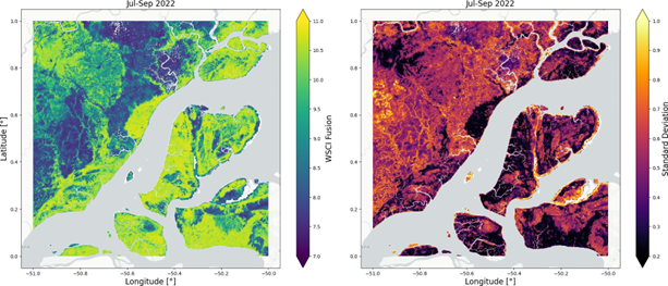
Figure 1. Example subset of mean (left) and uncertainty (right) estimates of Waveform Structural Complexity Index (WSCI) from the GEDI L4C Fusion product over the Eastern Amazon between July and September 2022.
Citation
De Conto, T., J. Armston, and R.O. Dubayah. 2026. GEDI L4C Global Waveform Structural Complexity Index (WSCI) Fusion Product, Version 2. ORNL DAAC, Oak Ridge, Tennessee, USA. https://doi.org/10.3334/ORNLDAAC/2474
Table of Contents
- Dataset Overview
- Data Characteristics
- Application and Derivation
- Quality Assessment
- Data Acquisition, Materials, and Methods
- Data Access
- References
Dataset Overview
The GEDI L4C Fusion product transforms the sparse sampling pattern of GEDI's footprint-level WSCI estimates (De Conto et al., 2024) into wall-to-wall maps through a multi-sensor fusion approach. WSCI quantifies the three-dimensional structural complexity of forest canopies, serving as a critical indicator of ecosystem functioning, biodiversity, and carbon dynamics (De Conto et al., 2024; Liu et al., 2022, 2024).
The fusion methodology addresses the fundamental limitation of GEDI's orbital sampling pattern, which creates spatial gaps between beam transects spaced approximately 600 meters apart. By leveraging the complementary strengths of lidar and radar remote sensing, this product provides consistent structural complexity estimates across Earth's land surface, including regions beyond GEDI's observational limits and time periods predating the mission's 2019 operational start.
The modeling framework employed 1×1-km spatial tiles sampled at 3-month intervals, matching the temporal aggregation of Sentinel-1 data while maintaining the 25-meter spatial resolution consistent with GEDI's footprint size. This approach ensures that predictions are directly comparable to both the source GEDI L4C WSCI estimates and independent airborne laser scanning measurements of 3D canopy entropy.
Project: Global Ecosystem Dynamics Investigation (GEDI)
The Global Ecosystem Dynamics Investigation (GEDI) produces high resolution laser ranging observations of the 3D structure of the Earth. GEDI’s precise measurements of forest canopy height, canopy vertical structure, and surface elevation greatly advance our ability to characterize important carbon and water cycling processes, biodiversity, and habitat. GEDI was funded as a NASA Earth Ventures Instrument (EVI) mission. It was launched to the International Space Station in December 2018 and completed initial orbit checkout in April 2019.
Related Publication
de Conto, T., Armston, J. and Dubayah, R., 2026. Scalable deep fusion of spaceborne lidar and synthetic aperture radar for global forest structural complexity mapping. Machine Learning: Earth, 2(1), p.015002. https://doi.org/10.1088/3049-4753/ae2c01
Related Datasets
Dubayah, R., Hofton, M., Blair, J., Armston, J., Tang, H., Luthcke, S., 2021a. GEDI L2A Elevation and Height Metrics Data Global Footprint Level V002. https://doi.org/10.5067/GEDI/GEDI02_A.002
Dubayah, R., Tang, H., Armston, J., Luthcke, S., Hofton, M., Blair, J., 2021b. GEDI L2B Canopy Cover and Vertical Profile Metrics Data Global Footprint Level V002. https://doi.org/10.5067/GEDI/GEDI02_B.002
De Conto, T., J. Armston, and R. Dubayah. 2024b. Global Ecosystem Dynamics Investigation (GEDI) GEDI L4C Footprint Level Waveform Structural Complexity Index, Version 2. https://doi.org/10.3334/ORNLDAAC/2338
Acknowledgements
This work was funded with a NASA Earth Ventures Instrument (EVI) supporting the GEDI mission (contract NNL15AA03C), and FINESST (grant NNH21ZDA001N).
Data Characteristics
Spatial Coverage: Global
Spatial Resolution: 25 m
Temporal Coverage: 2015-01-01 to 2023-03-01
Temporal Resolution: 3 month
Study Area: Latitude and longitude are given in decimal degrees
| Site | Westernmost Longitude | Easternmost Longitude | Northernmost Latitude | Southernmost Latitude |
|---|---|---|---|---|
| Global | -177.70 | 178.70 | 75.11 | -56.00 |
Data File Information
There are 470,414 data files in cloud-optimized GeoTIFF (COG) format (.tif) in this dataset.
The files are named GEDI_L4C_WSCI_FUSION_<SSSWWWW>_<NNNEEEE>_<YYYYMMDD>_<YYYYMMDD>.tif, where:
- GEDI_L4C_WSCI_FUSION = product short name representing GEDI Level 4C Fusion data,
- <SSSWWWW> = lower left geographical limits (southwest corner),
- <NNNEEEE> = upper right geographical limits (northeast corner),
- <YYYYMMDD> = date range represented in the file:
- First occurence: first day considered for SAR acquisitions (SAR dates on or after YYYYMMDD)
- Second occurence: day after the last day considered for SAR acquisitions (SAR dates before YYYYMMDD)
Example file name: GEDI_L4C_WSCI_FUSION_00N051W_01N050W_20220701_20221001.tif
GeoTIFF characteristics
- Coordinate system: geographic coordinates using WGS 84 datum (EPSG: 4326)
- Four bands (see Table 1).
- Spatial resolution: 0.000225 degree (~25 m)
Table 1: WSCI Fusion product image layers.
| Band number | Description |
|---|---|
| 1 | Mean WSCI estimate at 25 m resolution |
| 2 | Aleatoric standard deviation estimate (data uncertainty) |
| 3 | Epistemic standard deviation estimate (model uncertainty) |
| 4 | Fraction of valid input data (non-missing pixels across all SAR datasets) |
Application and Derivation
The GEDI L4C footprint product provides estimates of 3D structural complexity at a near-global scale, but its sparse sampling pattern limits spatial continuity for local-scale applications (De Conto et al., 2024; Dubayah et al., 2020). This fusion product overcomes this limitation by establishing empirical relationships between GEDI-derived WSCI and coincident SAR backscatter patterns within 1×1-km spatial contexts.
The deep learning architecture learns complex, non-linear associations between multi-frequency SAR responses and lidar-derived structural complexity. This enables the model to interpolate WSCI values in areas between GEDI tracks and extrapolate to regions and time periods beyond GEDI's direct observations. The approach facilitates: continuous monitoring of canopy structural complexity at local to global scales; temporal change detection spanning 2015-2022, extending beyond GEDI's operational period; assessment of structural complexity in high-latitude forests (>51.6°) outside GEDI's coverage; and direct validation using airborne or terrestrial laser scanning systems. The fusion predictions maintain consistency with both GEDI L4C WSCI estimates and independent 3D canopy entropy measurements from airborne lidar, ensuring scientific continuity across data sources.
Quality Assessment
Model validation employed a spatial partitioning strategy to ensure geographical transferability. The training dataset of approximately 5 million 1×1-km image chips was divided into ~80×80-km blocks, with 80% used for training and 20% reserved for independent validation. This approach controls overfitting and tests the model's ability to generalize to unseen geographical locations.
Performance evaluation utilized multiple assessment strategies:
GEDI validation: Standard regression metrics (RMSE, bias, R²) computed against withheld GEDI samples at ecoregion scales across all temporal periods (April 2019 - December 2022).
Airborne lidar validation: Independent assessment using high-quality airborne lidar reference data from:
- National Ecological Observatory Network (NEON) sites across the United States (NEON, 2024)
- Estimativa de Biomassa para a Amazônia (EBA) transects in the Brazilian Amazon (Ometto et al., 2023a, 2023b)
- Uncertainty quantification: The model generates calibrated uncertainty estimates through:
- Aleatoric uncertainty: capturing inherent data variability and observational noise
- Epistemic uncertainty: quantifying model confidence through Monte Carlo dropout and ensemble predictions across overlapping spatial windows
The fraction of valid input data (Band 4, Table 1) provides users with transparency regarding prediction reliability, with values below 1.0 indicating reliance on spatial context for gap-filling.
Data Acquisition, Materials, and Methods
The fusion product integrates three primary data sources with complementary characteristics:
GEDI L4C Footprint Product
The Global Ecosystem Dynamics Investigation mission, launched December 5, 2018, operates from the International Space Station using three lasers that produce eight beam ground transects. Each beam samples ~25 m diameter footprints every 60 m along-track, with ~600 m cross-track spacing creating a 4.2 km swath width (Dubayah et al., 2020). The L4C product provides WSCI estimates at the footprint level derived from machine learning models relating GEDI Level 2A relative height (RH) metrics (Dubayah et al., 2021a) to airborne lidar measurements of 3D canopy entropy (De Conto et al., 2024; Liu et al., 2022). Models were trained separately for four plant functional types: deciduous broadleaf trees, evergreen broadleaf trees, evergreen needleleaf trees, and combined grasslands/shrubs/woodlands (De Conta et al., 2024).
Multi-sensor SAR Stack
- Sentinel-1 (Mullissa et al., 2021): C-band (5.4 GHz) VV/VH polarization backscatter and ellipsoidal incidence angle, aggregated quarterly to match the 3-month temporal resolution.
- ALOS-2 PALSAR-2 (Shimada et al., 2014): L-band (1.3 GHz) HH/HV polarization backscatter and ground incidence angle from annual mosaics, providing deeper canopy penetration.
- Copernicus DEM (European Space Agency and Airbus, 2022): Digital elevation model derived from TanDEM-X interferometric SAR, providing topographic context.
All SAR products were projected and resampled to 25-meter resolution using bilinear interpolation to match GEDI's footprint size.
Deep Learning Architecture
The adapted EfficientNetV2 architecture (Tan and Le, 2021) simultaneously predicts mean WSCI and associated uncertainties through dual output heads and ensemble predictions. The model employs: input dimensions: 40×40 pixels (1×1 km at 25-m resolution) × multimodal SAR channels; dual output heads for mean and aleatoric uncertainty estimation; Monte Carlo dropout and spatial ensemble averaging for epistemic uncertainty quantification; and training on ~133 million GEDI footprints from April 2019 to December 2022.
Permanent water bodies were masked using the ESA WorldCover product (Zanaga et al., 2022). Predictions extend globally, including latitudes beyond GEDI's 51.6° limits, wherever SAR data coverage exists. Data gaps may occur in regions or time periods with missing Sentinel-1 or PALSAR observations.
Data Access
These data are available through the Oak Ridge National Laboratory (ORNL) Distributed Active Archive Center (DAAC).
GEDI L4C Global Waveform Structural Complexity Index (WSCI) Fusion Product, Version 2
Contact for Data Center Access Information:
- E-mail: uso@daac.ornl.gov
- Telephone: +1 (865) 241-3952
References
de Conto, T., Armston, J. and Dubayah, R., 2026. Scalable deep fusion of spaceborne lidar and synthetic aperture radar for global forest structural complexity mapping. Machine Learning: Earth, 2(1), p.015002. https://doi.org/10.1088/3049-4753/ae2c01
De Conto, T., J. Armston, and R. Dubayah. 2024. Global Ecosystem Dynamics Investigation (GEDI) GEDI L4C Footprint Level Waveform Structural Complexity Index, Version 2. https://doi.org/10.3334/ORNLDAAC/2338
Dubayah, R., J.B. Blair, S. Goetz, L. Fatoyinbo, M. Hansen, S. Healey, M. Hofton, G. Hurtt, J. Kellner, S. Luthcke, J. Armston, H. Tang, L. Duncanson, S. Hancock, P. Jantz, S. Marselis, P.L. Patterson, W. Qi, and C. Silva. 2020. The Global Ecosystem Dynamics Investigation: High-resolution laser ranging of the Earth’s forests and topography. Science of Remote Sensing 1:100002. https://doi.org/10.1016/j.srs.2020.100002
Dubayah, R., M. Hofton, J. Blair, J. Armston, H. Tang, and S. Luthcke. 2021a. GEDI L2A Elevation and Height Metrics Data Global Footprint Level V002. NASA Land Processes Distributed Active Archive Center. https://doi.org/10.5067/GEDI/GEDI02_A.002
Dubayah, R., H. Tang, J. Armston, S. Luthcke, M. Hofton, and J. Blair. 2021b. GEDI L2B Canopy Cover and Vertical Profile Metrics Data Global Footprint Level V002. NASA Land Processes Distributed Active Archive Center. https://doi.org/10.5067/GEDI/GEDI02_B.002
European Space Agency, Airbus. 2022. Copernicus DEM. https://doi.org/10.5270/ESA-c5d3d65
Liu, X., Y. Feng, T. Hu, Y. Luo, X. Zhao, J. Wu, E.E. Maeda, W. Ju, L. Liu, Q. Guo, and Y. Su. 2024. Enhancing ecosystem productivity and stability with increasing canopy structural complexity in global forests. Science Advances 10. https://doi.org/10.1126/sciadv.adl1947
Liu, X., Q. Ma, X. Wu, T. Hu, Z. Liu, L. Liu, Q. Guo, and Y. Su. 2022. A novel entropy-based method to quantify forest canopy structural complexity from multiplatform lidar point clouds. Remote Sensing of Environment 282:113280. https://doi.org/10.1016/j.rse.2022.113280
Mullissa, A., A. Vollrath, C. Odongo-Braun, B. Slagter, J. Balling, Y. Gou, N. Gorelick, and J. Reiche. 2021. Sentinel-1 SAR Backscatter Analysis Ready Data Preparation in Google Earth Engine. Remote Sensing 13:1954. https://doi.org/10.3390/rs13101954
National Ecological Observatory Network (NEON), 2024. Discrete return LiDAR point cloud (DP1.30003.001). https://doi.org/10.48443/hj77-kf64
Ometto, J., E.B. Gorgens, F.R. de S. Pereira, L. Sato, M.L. R. Assis, R. Cantinho, M. Longo, A.D. Jacon, and M. Keller. 2023a. 2023 March 01. L1A - Discrete airborne LiDAR transects collected by EBA in the Brazilian Amazon (Roraima e Amapá). Zenodo. https://doi.org/10.5281/zenodo.7689693
Ometto, J.P., E.B. Gorgens, F.R. de Souza Pereira, L. Sato, M.L. R. de Assis, R. Cantinho, M. Longo, A.D. Jacon, and M. Keller. 2023b. A biomass map of the Brazilian Amazon from multisource remote sensing. Scientific Data 10. https://doi.org/10.1038/s41597-023-02575-4
Shimada, M., T. Itoh, T. Motooka, M. Watanabe, T. Shiraishi, R. Thapa, and R. Lucas. 2014. New global forest/non-forest maps from ALOS PALSAR data (2007–2010). Remote Sensing of Environment 155:13–31. https://doi.org/10.1016/j.rse.2014.04.014
Tan, M., and Q.V. Le. 2021. EfficientNetV2: Smaller Models and Faster Training. arXiv arXiv:2104.00298 https://doi.org/10.48550/ARXIV.2104.00298
Zanaga, D., R. Van De Kerchove, D. Daems, W. De Keersmaecker, C. Brockmann, G. Kirches, J. Wevers, O. Cartus, M. Santoro, S. Fritz, M. Lesiv, M. Herold, N.-E. Tsendbazar, P. Xu, F. Ramoino, and O. Arino. 2022. 2022 October 28. ESA WorldCover 10 m 2021 v200. Zenodo. https://doi.org/10.5281/ZENODO.7254221