Documentation Revision Date: 2016-08-16
Data Set Version: R1
Summary
This data set contains four data files in text format.
Revision Notes: Only the documentation for this data set has been modified. The data files for this data set were originally published in 2007.

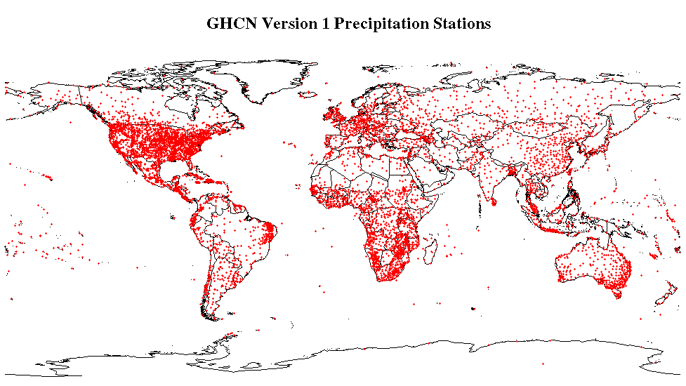
Figure 1: Locations of approximately 7500 precipitation stations around the world in GHCN Version 1.
Citation
Vose, R.S., R.L. Schmoyer, P.M. Steurer, T.C. Peterson, R. Heim, T.R. Karl, and J.K. Eischeid. 2016. Global Historical Climatology Network, 1753-1990. ORNL DAAC, Oak Ridge, Tennessee, USA. http://dx.doi.org/10.3334/ORNLDAAC/220
Table of Contents
- Data Set Overview
- Data Characteristics
- Application and Derivation
- Quality Assessment
- Data Acquisition, Materials, and Methods
- Data Access
- References
- Data Set Revisions
Data Set Overview
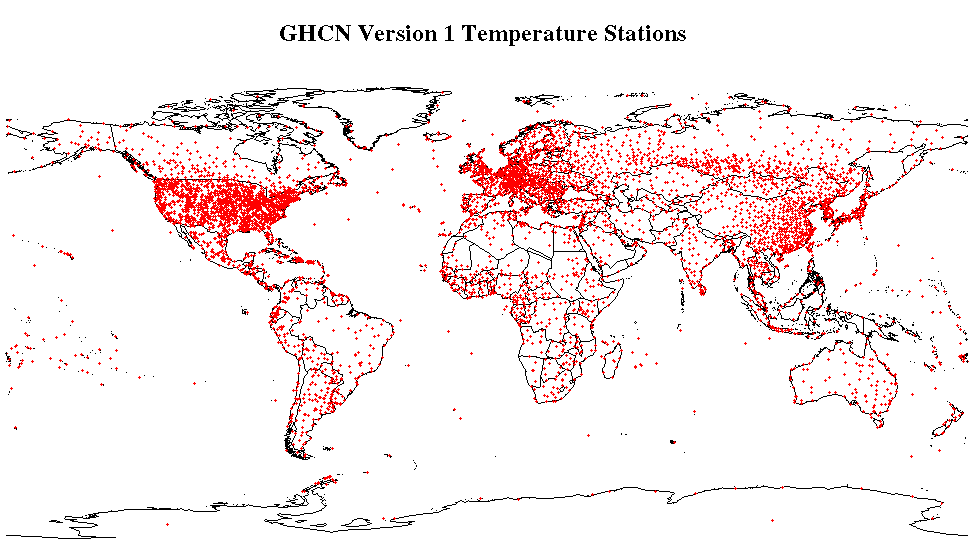
This data set contains monthly temperature, precipitation, sea-level pressure, and station-pressure data for thousands of meteorological stations worldwide. The database was compiled from pre-existing national, regional, and global collections of data as part of the Global Historical Climatology Network (GHCN) project, the goal of which is to produce, maintain, and make available a comprehensive global surface baseline climate data set for monitoring climate and detecting climate change. It contains data from roughly 6000 temperature stations, 7500 precipitation stations, 1800 sea level pressure stations, and 1800 station pressure stations. Each station has at least 10 years of data, 40% have more than 50 years of data. Spatial coverage is good over most of the globe, particularly for the United States and Europe. Data gaps are evident over the Amazon rainforest, the Sahara Desert, Greenland, and Antarctica.
Data Characteristics
This data set contains four data files in text format, one for precipitation, atmospheric pressure at sea level, atmospheric pressure at each station, and temperature data.
Table 1. Data files
|
File Name |
Temporal Range |
Description |
|
precip.data.Z |
1753-01-01 - 1990-12-31 |
Total monthly precipitation data in tenths of millimeters. |
|
press.sea.data.Z |
1753-01-01 - 1990-12-31 |
Mean monthly sea level pressure data in tenths of millibars. |
|
press.sta.data.Z |
1753-01-01 - 1990-12-31 |
Mean monthly station pressure data in tenths of millibars. |
|
temp.data.Z |
1753-01-01 - 1990-12-31 |
Mean monthly temperature data in tenths of degrees Celsius. |
Table 2. Data fields in the four data files that contain time series of monthly climatic measurements
|
Data Field |
Description |
|
Country |
Country identification number is a three-digit country code |
|
Station |
A seven-digit station identification number. |
|
Year |
Year of the data record. |
|
Month1-12 |
Monthly data values in mm for precipitation, tenths of milibars for atmospheric pressure, or Deg C for temperature. |
Table 3. Nineteen (19) companion files accompany the data set.
|
File Name |
Description |
|
ndp041.doc |
Readme file describing the data set (in .doc format) |
|
ndp041.txt |
Readme file describing the data set (in .txt format) |
|
ghcn.pdf |
Data set user guide in .pdf format. |
|
flag.for |
FORTRAN IV data retrieval routine to read and print the flag code files |
|
data.for |
FORTRAN IV data retrieval routine to read and print the climate data files |
|
invent.for |
FORTRAN IV data retrieval routine to read and print the station inventory files |
|
flag.sas |
SAS data retrieval routine to read and print the flag code files |
|
data.sas |
SAS data retrieval routine to read and print the climate data files |
|
invent.sas |
SAS data retrieval routine to read and print the station inventory file |
|
cocodes.f1 |
Country code file sorted by country name |
|
cocodes.f2 |
Country code file sorted by country code |
|
press.sta.statinv |
Station level pressure station inventory file provides a list of the 1873 stations associated with the mean monthly station pressure data set |
|
press.sea.statinv |
Sea level pressure station inventory file provides a list of the 1883 stations associated with the mean monthly sea level pressure data set. |
|
precip.statinv |
Precipitation station inventory file provides a list of the 7533 stations associated with the total monthly precipitation data set |
|
temp.statinv |
Temperature station inventory file provides a list of the 6039 stations associated with the mean monthly temperature data set |
|
press.sta.flag.Z |
Station level pressure flag code file provides the flag codes for the mean monthly station pressure data set. |
|
press.sea.flag.Z |
Sea level pressure flag code file provides the flag codes for the mean monthly sea level pressure data set. |
|
precip.flag.Z |
Precipitation flag code file provides the flag codes for the total monthly precipitation data set. |
|
temp.flag.Z |
Temperature flag code file provides the flag codes for the mean monthly temperature data set. |
Table 4. Data fields in the four data station inventory files (*.statinv)
|
Data Field |
Units |
Description |
|
COUNTRY |
|
Country identification number is a three-digit country code |
|
STATION |
|
A seven-digit station identification number. |
|
Name |
|
Name of the station |
|
Lat |
Decimal Degrees |
Latitude of the station |
|
Lon |
Decimal Degrees |
Longitude of the station |
|
Elev |
Meters |
Elevation of the station |
|
First |
|
First year for which data are available at this station |
|
Last |
|
Last year for which data are available at this station |
|
Missing |
|
Percent of the record with missing data |
|
Disc |
|
A code which can be used to identify a time series which contains a discontinuity |
Table 5. Data fields in the four flag code files (*.flag)
|
Data Field |
Description |
|
COUNTRY |
Country identification number is a three-digit country code |
|
STATION |
A seven-digit station identification number. |
|
Year |
Year of the data record |
|
Source1-12 |
Codes indicating the source of each monthly data value |
|
Revise1-12 |
Codes indicating whether or not each monthly value has been revised 1 = original observation appeared problematic and therefore was revised 0 = the original observation did not seem problematic and therefore was not revised 9 = observation is missing |
|
Suspect1-12 |
Codes indicating whether or not each monthly value is a suspect for “gross” errors. 1 = observation is a suspect 0 = observation does not seem to be a suspect 9 = observation is missing |
|
Disc1-12 |
Codes indicating whether or not there is a discontinuity in the time series beginning with this month 1 = then the station has a major discontinuity 0 = then the station has no major discontinuities 9 = observation is missing |
Application and Derivation
The database was compiled from pre-existing national, regional, and global collections of data as part of the Global Historical Climatology Network (GHCN) project, the goal of which is to produce, maintain, and make available a comprehensive global surface baseline climate data set for monitoring climate and detecting climate change.
Quality Assessment
Quality Control of the database included visual inspection of graphs of all station time series, tests for precipitation digitized 6 months out of phase, tests for different stations having identical data, and other tests. This detailed analysis has revealed that most stations (95% for temperature and precipitation; 75% for pressure) contain high-quality data. However, gross data-processing errors (e.g., keypunch problems) and discontinuous inhomogeneities (e.g., station relocations and instrumentation changes) do characterize a small number of stations. All major data processing problems have been flagged (or corrected, when possible). Similarly, all major inhomogeneities have been flagged, although no homogeneity corrections were applied.
Data Acquisition, Materials, and Methods
The GHCN database was assembled from the various national-, continental-, and global-scale data bases and consists of mean monthly temperature (in tenths of degrees celsius), precipitation (in tenths of millimeters), sea level pressure (in tenths of millibars) and station pressure (in tenths of millibars) for thousands of meteorological stations worldwide. The database was compiled from pre-existing national, regional, and global collections of data as part of the Global Historical Climatology Network (GHCN) project and contains data from roughly 6000 temperature stations, 7500 precipitation stations, 1800 sea level pressure stations, and 1800 station pressure stations. Each station has at least 10 years of data, 40% have more than 50 years of data. Most records end in the 1980s. No data are available for any station after 1990. Spatial coverage is good over most of the globe, particularly for the United States and Europe. Data gaps are evident over the Amazon rainforest, the Sahara Desert, Greenland, and Antarctica.

Figure 2: Locations of approximately 6000 stations recording temperature around the world in GHCN Version 1.
In addition, the compilation of the GHCN data base entailed scrutinizing and revising all station inventory parameters (i.e., country codes, station numbers, station names, latitudes, longitudes, and elevations). Whenever possible, all such parameters were updated with the most recent information available from the World Meteorological Organization (WMO). Assigned 3-digit country codes for all countries in the GHCN may be found in the files cocodes.f1 (sorted by country name) and cocodes.f2 (sorted by country code), which are contained in the CDIAC online directory /pub/ndp041. These files can serve as the starting point for a user who wishes to work with data from select countries. Finally, all data sets were merged and "duplicate" stations were removed and subjected to a two-part quality control analysis.
Data Access
These data are available through the Oak Ridge National Laboratory (ORNL) Distributed Active Archive Center (DAAC).
Global Historical Climatology Network, 1753-1990
Contact for Data Center Access Information:
- E-mail: uso@daac.ornl.gov
- Telephone: +1 (865) 241-3952
References
Vose, R. S., R. L. Schmoyer, P. M. Steurer, T. C. Peterson, R. Heim, T. R. Karl, and J. K. Eischeid. 1992. The Global Historical Climatology Network; Long-Term Monthly Temperature, Precipitation, Sea Level Pressure, and Station Pressure Data. ORNL/CDIAC-53, NDP-041. Available on-line [http://cdiac.esd.ornl.gov/epubs/ndp/ndp041/ndp041.html] from Carbon Dioxide Information Analysis Center (CDIAC), Oak Ridge National Laboratory, Oak Ridge, Tennessee, U.S.A.
Data Set Revisions
The original citation for this data set was:
Vose, R. S., R. L. Schmoyer, P. M. Steurer, T. C. Peterson, R. Heim, T. R. Karl, and J. K. Eischeid. 2007. Global Historical Climatology Network, 1753-1990. ORNL DAAC, Oak Ridge, Tennessee, USA.