Documentation Revision Date: 2026-02-05
Dataset Version: 1
Summary
This dataset holds 1853 files in cloud-optimized GeoTIFF format. There are 1852 files that depict the ice fraction of small water bodies in the ACP on a given day, and one GeoTIFF that provides the relative root mean square error (RRMSE) of the ice fraction estimates for each 1-km grid cell.
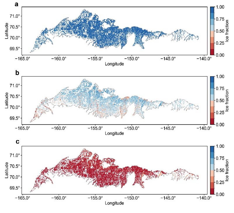
Figure 1. Multi-year mean 1-km ice fraction maps for small water bodies on the Arctic Coastal Plain of Alaska for May (a), June (b), and July (c). Only grid cells where small water bodies cover at least 1% of grid cell area are shown.
Citation
Lin, H., J. Du, and J.S. Kimball. 2026. ABoVE: Ice Fraction of Small Water Bodies in the Arctic Coastal Plain, 2017-2023. ORNL DAAC, Oak Ridge, Tennessee, USA. https://doi.org/10.3334/ORNLDAAC/2451
Table of Contents
- Dataset Overview
- Data Characteristics
- Application and Derivation
- Quality Assessment
- Data Acquisition, Materials, and Methods
- Data Access
- References
Dataset Overview
This dataset contains ice fraction data at 1-km spatial resolution and approximately 6-day temporal resolution for small water bodies (900 m2 to 25 km2) across the Arctic Coastal Plain of Alaska (ACP) from 2017 to 2023. The data were developed using Sentinel-1 Synthetic Aperture Radar (SAR) imagery, texture features, and temperature data. Ice fraction is summarized for 1-km grid cells.
Ice cover of water bodies in the northern high latitudes (NHL) is highly sensitive to the changing climate, and its dynamics exert substantial impacts on the NHL ecosystems, hydrological processes, and carbon cycle. An ice fraction dataset for small water bodies (900 m2 to 25 km2) across the Arctic Coastal Plain of Alaska (ACP) from 2017 to 2023 (Figure 1) was developed with a temporal resolution of about six days using Sentinel-1 Synthetic Aperture Radar (SAR) imagery, texture features, and temperature data (Figure 2).
Compared with the Google Dynamic World (DW; Brown et al., 2022) product derived from Sentinel-2 observations, this dataset shows high consistency with DW (R =0.91, RMSE= 0.19) while having enhanced temporal coverage due to fewer constraints from solar illumination, cloud cover, and atmospheric conditions. This dataset helps to fill the gap in ice phenology studies for small water bodies, improve our understanding on the interactions between ice dynamics and climate change, and enhance the coupled modelling of ice and carbon processes (Du et al., 2017).
Project: Arctic-Boreal Vulnerability Experiment
The Arctic-Boreal Vulnerability Experiment (ABoVE) is a NASA Terrestrial Ecology Program field campaign based in Alaska and western Canada between 2016 and 2025. Research for ABoVE links field-based, process-level studies with geospatial data products derived from airborne and satellite sensors, providing a foundation for improving the analysis and modeling capabilities needed to understand and predict ecosystem responses and societal implications.
Related Publications:
Lin H., J. Du, J. Kimball, X. Cheng, P. Donnelly, J. Watts, and A. Bartsch. 2025. A satellite-based ice fraction record for small water bodies of the Arctic Coastal Plain. Earth System Science Data (in review).
Acknowledgments:
This research was funded through NASA Terrestrial Ecology Program’s ABoVE field campaign (grant 80NSSC22K1238).
Data Characteristics
Spatial Coverage Arctic Coastal Plain of Alaska
ABoVE Reference Locations:
Domain: Alaska
Grid cells: Ah000-001v000-001
Spatial resolution: 1 km
Temporal coverage: 2017-01-05 to 2023-12-28.
Temporal resolution: 6 days
Study Areas (All latitude and longitude given in decimal degrees)
| Site | Westernmost Longitude | Easternmost Longitude | Northernmost Latitude | Southernmost Latitude |
|---|---|---|---|---|
| Alaska, US | -164.4308 | -140.1885 | 71.3560 | 68.8998 |
Data File information
The dataset holds 1853 files in cloud-optimized GeoTIFF format (.tif). There are 1852 data files that hold the ice fraction of small water bodies in the ACP on a given day, observed by both ascending and descending Sentinel-1 passes, and recorded as the fraction of ice-covered area within small water bodies in each 1-km grid cell. Each image contains two bands: (1) ice fraction, with values ranging from 0 to 1, and (2) the area fraction of small water bodies within each 1-km grid cell, also ranging from 0 to 1.
The naming convention for the ice fraction GeoTIFFs is ice_fraction_swb_proportion_<YYYYMMDD>.tif, where
<YYYYMMDD> is the date of the estimate.
Example file name: ice_fraction_swb_proportion_20170105.tif
Properties of ice fraction GeoTIFFs
- Coordinate system: Alaska Albers Equal Area projection, NAD83 datum (EPSG: 3338)
- Map units: meters
- Resolution: 1000 m
- Two Bands: Band 1 = ice fraction within a given 1-km grid cell. Band 2 = water proportion (areal percentage of the small water bodies,swb, over a given 1-km grid cell).
- Nodata value: -9999
The file ice_fraction_swb_quality_layer.tif provides the relative root mean square error (RRMSE) of the ice fraction estimates for each 1-km grid cell. This GeoTIFF has the same properties but only one band: RRMSE.
Application and Derivation
This dataset helps to fill the gap in ice phenology studies for small water bodies, improve our understanding on the interactions between ice dynamics and climate change, and enhance the coupled modelling of ice and carbon processes.
Quality Assessment
To assess the ice fraction data quality, all paired Google Dynamic World (DW; Brown et al., 2022) and the resulting ice fraction observations were collected on the same dates from 2017 to 2023 for each grid cell. The relative root mean square error (RRMSE) was then calculated for each grid based on these data pairs. The resulting RRMSE map serves as a quality flag layer for the ice fraction product. Compared with the DW product derived from Sentinel-2 observations, the resulting dataset shows high consistency with DW (R =0.91, RMSE= 0.19) while having enhanced temporal coverage due to less radar constraints from solar illumination, cloud cover, and atmospheric conditions.
Data Acquisition, Materials, and Methods
Data sources used in the study included Sentinel-1 A/B radar backscatter, Sentinel-2 based Google Dynamic World (DW; Brown et al., 2022) fractional classifications, and water masks derived from Global Lakes and Wetlands Database Version 2 (GLWD v2; Lehner et al., 2025) and the Joint Research Centre Global Surface Water (GWS; Pekel et al., 2016) products.
Workflow
The Sentinel-1 (S1) data (Torres et al., 2012) were pre-processed before being fed into the random forest (RF) model, which included incidence angle normalization, de-speckling using Refined Lee filtering, texture calculation, image clipping, and water body masking. To train and test the RF-based ice detection model, a dataset was constructed using DW ice/non-ice classifications as the predicted variable, and S1 VV and VH backscatter coefficients, VV_corr, and Daymet air temperature variables (Thornton et al., 2021) as predictor variables. The trained ice detection models were applied to each S1 image throughout the study period to produce 10-m resolution ice cover maps for small water bodies in the Arctic Coastal Plain of Alaska (ACP). Finally, the study area was divided into 1-km grid cells, and the ice fraction was calculated for each grid cell based on the 10-m ice cover maps. The workflow is summarized by Figure 2.
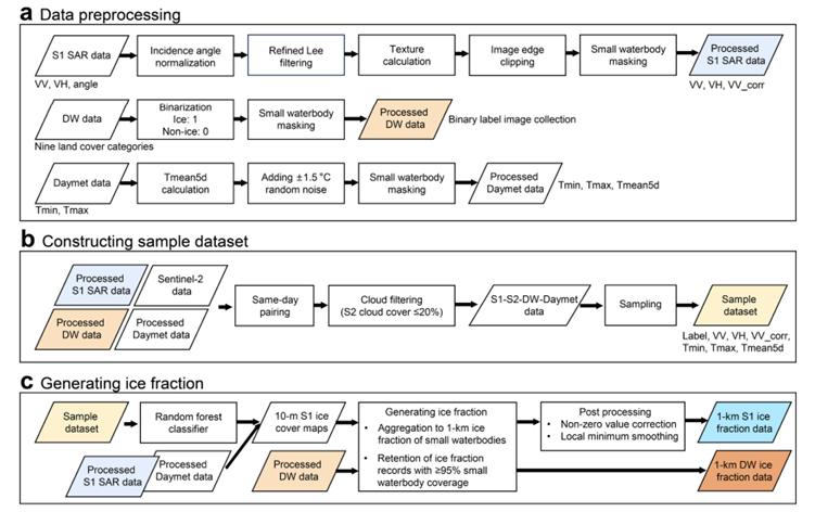
Figure 2. Schematic of workflow used to derive ice fraction products.
Data Access
These data are available through the Oak Ridge National Laboratory (ORNL) Distributed Active Archive Center (DAAC).
ABoVE: Ice Fraction of Small Water Bodies in the Arctic Coastal Plain, 2017-2023
Contact for Data Center Access Information:
- E-mail: uso@daac.ornl.gov
- Telephone: +1 (865) 241-3952
References
Brown, C.F., S.P. Brumby, B. Guzder-Williams, T. Birch, S.B. Hyde, J. Mazzariello, W. Czerwinski, V.J. Pasquarella, R. Haertel, and S. Ilyushchenko. 2022. Dynamic World, Near real-time global 10 m land use land cover mapping. Scientific Data 9:251. https://doi.org/10.1038/s41597-022-01307-4
Du, J., J.S. Kimball, C. Duguay, Y. Kim, and J.D. Watts. 2017. Satellite microwave assessment of Northern Hemisphere lake ice phenology from 2002 to 2015. The Cryosphere 11:47–63. https://doi.org/10.5194/tc-11-47-2017
Lehner, B., M. Anand, E. Fluet-Chouinard, F. Tan, F. Aires, G.H. Allen, P. Bousquet, J.G. Canadell, N. Davidson, M. Ding, C.M. Finlayson, T. Gumbricht, L. Hilarides, G. Hugelius, R.B. Jackson, M.C. Korver, L. Liu, P.B. McIntyre, S. Nagy, D. Olefeldt, T.M. Pavelsky, J.-F. Pekel, B. Poulter, C. Prigent, J. Wang, T.A. Worthington, D. Yamazaki, X. Zhang, and M. Thieme. 2025. Mapping the world’s inland surface waters: an upgrade to the Global Lakes and Wetlands Database (GLWD v2). Earth System Science Data 17:2277–2329. https://doi.org/10.5194/essd-17-2277-2025
Lin H., J. Du, J. Kimball. X.Cheng, P. Donnelly, J. Watts, and A. Bartsch. 2025. A satellite-based ice fraction record for small water bodies of the Arctic Coastal Plain. Earth System Science Data (in review).
Pekel, J.-F., A. Cottam, N. Gorelick, and A.S. Belward. 2016. High-resolution mapping of global surface water and its long-term changes. Nature 540:418–422. https://doi.org/10.1038/nature20584
Thornton, P.E., R. Shrestha, M. Thornton, M., S.-C. Kao, Y. Wei, and B.E. Wilson. 2021. Gridded daily weather data for North America with comprehensive uncertainty quantification, Scientific Data 8:190. https://doi.org/10.1038/s41597-021-00973-0
Torres, R., P. Snoeij, D. Geudtner, D. Bibby, M. Davidson, E. Attema, P. Potin, B. Rommen, N. Floury, M. Brown, I.N. Traver, P. Deghaye, B. Duesmann, B. Rosich, N. Miranda, C. Bruno, M. L’Aabbate, R. Croci, A. Pietropaola, M. Huchler, and F. Rostan. 2012. GMES Sentinel-1 mission. Remote Sensing of Environment 120:9-24. https://doi-org.ornl.idm.oclc.org/10.1016/j.rse.2011.05.028