Documentation Revision Date: 2026-07-20
Dataset Version: 1
Summary
There are 645 data files in this dataset, which includes 129 ENVI files (each with binary + header),129 GeoTIFFs, 129 polygon files in Keyhole Markup Language (.kml) format, and 129 JPEG quicklook images.
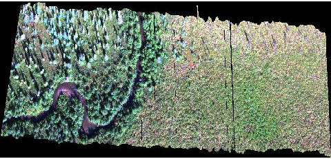
Figure 1. A quicklook image of imagery collected on July 29, 2018. Source: 100130_ChatanikaFlight3_attempt2_2018_07_29_20_32_59_raw_2925_rd_rf_or_RGB_quicklook.jpg.
Citation
Nelson, P.R. 2026. ABoVE: UAV VNIR Imaging Spectroscopy and Derived Plant Functional Types. ORNL DAAC, Oak Ridge, Tennessee, USA. https://doi.org/10.3334/ORNLDAAC/2503
Table of Contents
- Dataset Overview
- Data Characteristics
- Application and Derivation
- Quality Assessment
- Data Acquisition, Materials, and Methods
- Data Access
- References
Dataset Overview
This dataset contains orthorectified surface reflectance imagery in 326 bands (397 to 1000nm) and derived plant functional type (PFT) classification products generated from Unmanned Aerial Vehicle (UAV)-mounted Visible and Near-Infrared (VNIR) imaging spectrometers collected across multiple Arctic and boreal sites in Alaska in 2018 and 2019. Calibration was performed using dark and white reference measurements collected before each flight. Calibration and reflectance conversion were conducted using SpectralView software.
Project: ABoVE
The Arctic-Boreal Vulnerability Experiment (ABoVE) was a field campaign conducted in Alaska and western Canada for nearly ten years, starting in 2015. Researchers participating in ABoVE linked field-based, process-level studies with geospatial data products derived from airborne and satellite sensors. The work provided a foundation for improving the analysis and modeling capabilities needed to understand and predict ecosystem responses to, and societal implications of, climate change in the Arctic and boreal regions.
Related Dataset
Nelson, P.R. 2026. ABoVE: Ground-based Reflectance Spectra of Vegetation at Multiple Sites Across Alaska. ORNL DAAC, Oak Ridge, Tennessee, USA. https://doi.org/10.3334/ORNLDAAC/1980
- This dataset provides ground spectra of vegetation collected at, or near the same sites as this dataset and during the same time period. Those ground spectra were used to support interpretation, classification, and validation of UAV imagery-derived PFT products and to facilitate cross-scale comparison with AVIRIS-NG airborne observations.
Acknowledgements
This work was supported by NASA ABoVE Phase 1 and Phase 2 (grant NNX15AU05A), the Maine Economic Improvement Fund – Small Campus Initiative (2016 and 2018), and the Polar Studies Research Award from the Field Museum of Natural History.
Data Characteristics
Spatial Coverage: Multiple locations within the Alaskan Arctic and boreal regions of the NASA ABoVE Domain.
ABoVE Reference Locations
Domain: Core ABoVE
Spatial Resolution: Approximately 4–10 cm depending on flight altitude.
Temporal Coverage: July/Augest 2018 and August 2019
Temporal Resolution: Each site was typically surveyed once during a field season
Study Area: Latitude and longitude are given in decimal degrees for the overall extent of the dataset
| Site | Westernmost Longitude | Easternmost Longitude | Northernmost Latitude | Southernmost Latitude |
|---|---|---|---|---|
| Alaska | -164.6863 | -145.4218 | 65.4842 | 62.6587 |
Table 1. Extents of individual study areas in decimal degrees. Coordinates represent approximate site extents and may not exactly match individual image footprints. Note: There are site names in the data file names not included in this table, and there are no data files for some sites (e.g., Clayton_Lake).
| Site | North | South | West | East |
|---|---|---|---|---|
| Birch_Lake | 64.92069 | 64.91739 | -147.82652 | -147.81775 |
| Little_Lake | 64.41475 | 64.40732 | -146.90045 | -146.89133 |
| Big_Trail_Lake (Clayton_Lake) | 64.92074 | 64.91740 | -147.82661 | -147.81784 |
| Twelve_Mile | 65.40280 | 65.40091 | -145.98128 | -145.97652 |
| Murphy_Dome | 64.95453 | 64.94909 | -148.43821 | -148.34346 |
| Wickersham_Dome | 65.18981 | 65.18761 | -148.06786 | -148.06253 |
| Vault_Dr | 65.03629 | 65.03274 | -147.71349 | -147.70358 |
| Bison_Gulch | 63.80807 | 63.80565 | -148.95409 | -148.94956 |
| Chatnika | 65.15495 | 65.15254 | -147.48536 | -147.47630 |
| Clayton_Lake | 64.92066 | 64.91160 | -147.82431 | -147.82119 |
| Eagle_Summit | 65.48648 | 65.48209 | -145.42424 | -145.41247 |
Data File Information
There are 645 data files in this dataset:
- 129 ENVI images containing orthorectified surface reflectance in 326 bands (397-1000nm). Each ENVI includes a binary data file (.dat) and a ENVI header (.hdr) in text format
- 129 RGB Quicklook browse images in JPEG (.jpg) format derived from the hyperspectral imagery
- 129 Plant Functional Type (PFT) classification maps in cloud optimized GeoTIFF (.tif) format
- 129 polygons in Keyhole Markup Language (.kml) that show study plot boundaries
File naming conventions
Imagery Files:
The ENVI files are named <flightid>_<LOC>_<YYYY_MM_DD>_<HH_NN_SS>_raw_<ID>_rd_rf_or.<ext>, where
- <flightid> is a six digit UAV flight identifier
- <LOC> is the general site name (e.g., Murphy_Dome)
- <YYYY_MM_DD> is the date of acquisition (e.g., "2019_08_09")
- <HH_NN_SS> is the UTC time at start of flight (e.g., "21_28_52")
- <ID> is the Headwall sensor identifier
- "rd_rf_or" indicates that the raw data were converted radiance then reflectance and orthorectified
- <ext> indicates the file type: ENVI binary ("dat") or ENVI header ("hdr")
The quicklook files are named <flightid>_<LOC>_<YYYY_MM_DD>_<HH_NN_SS>_raw_<ID>_rd_rf_or_RGB_quicklook.jpg.
Note: There are 36 imagery files that do not include the location in the file name; however, geolocation information is included in the ENVI imagery.
Plant Functional Type Files:
The GeoTIFFs and KML polygon files are named UAS_PFT_map_flight_<flightid>_image_<imageid>_<YYYY_MM_DD>_<HH_NN_SS>.<ext>, where
- <flightid> is a six digit UAV flight identifier
- <imageid> is a one-to-four digit image identification number used match related files (same as <ID> above)
- <ext> indicates the file type: GeoTIFF ("tif") or Keyhole Markup Language ("kml")
Note: The GeoTIFF and KML files do not have site locations in their file names, but the flight and image identifiers may be used to associate them with their related ENVI and quicklook files.
The coordinate reference system for the GeoTIFFs is geographic coordinates using the WGS 84 datum (EPSG: 4326). The nodata value is 65535.
Example filenames for a single UAV flight:
- 100066_2018_07_25_21_18_45_raw_6425_rd_rf_or.dat
- 100066_2018_07_25_21_18_45_raw_6425_rd_rf_or.hdr
- 100066_2018_07_25_21_18_45_raw_6425_rd_rf_or_RGB_quicklook.jpg
- UAS_PFT_map_flight_100066_image_6425_2018_07_25_21_18_45.kml
- UAS_PFT_map_flight_100066_image_6425_2018_07_25_21_18_45.tif
Table 2. Pixel values and plant functional type (PFT) classes in GeoTIFFs derived from UAV VNIR data.
| Pixel value | PFT class |
|---|---|
| 0 | Abiotic |
| 1 | Forb |
| 2 | Graminoid |
| 3 | Lichen |
| 4 | Moss |
| 5 | Broadleaf Deciduous |
| 6 | Conifer Evergreen |
| 7 | Broadleaf Deciduous |
| 8 | Conifer Evergreen |
Application and Derivation
These data support fine-scale vegetation mapping, training and validation of airborne imaging spectroscopy products such as AVIRIS-NG, and ecological research within the NASA ABoVE domain.
Quality Assessment
Radiometric calibration was performed using dark and white reference measurements collected before each flight. Calibration and reflectance conversion were conducted using SpectralView software. Image quality was assessed through inspection of reference targets and cross-scene comparisons.
Data Acquisition, Materials, and Methods
This dataset contains high spatial resolution (approximately 4–10 cm ground sampling distance) Visible and Near-Infrared (VNIR) imagery and derived plant functional type (PFT) classification products generated from UAV-mounted VNIR imaging spectrometers collected across multiple Arctic and boreal sites in Alaska.
Each hyperspectral image was processed to generate spatially explicit maps of plant functional types at native UAV resolution. Imagery were collected during July and August of 2018 and 2019.
Data Access
These data are available through the Oak Ridge National Laboratory (ORNL) Distributed Active Archive Center (DAAC).
ABoVE: UAV VNIR Imaging Spectroscopy and Derived Plant Functional Types
Contact for Data Center Access Information:
- E-mail: uso@daac.ornl.gov
- Telephone: +1 (865) 241-3952
References
Nelson, P.R. 2026. ABoVE: Ground-based Reflectance Spectra of Vegetation at Multiple Sites Across Alaska. ORNL DAAC, Oak Ridge, Tennessee, USA. https://doi.org/10.3334/ORNLDAAC/1980