Documentation Revision Date: 2019-06-12
Dataset Version: 1
Summary
Rnet at the land surface is the sum of net shortwave (RSnet) and net longwave (RLnet) radiation, where RSnet is incoming shortwave solar radiation (RS) minus the fraction reflected by the land surface (RS * albedo) and RLnet is the difference between incoming and outgoing longwave radiative fluxes. The Rnet estimates were validated with measurements from a net radiometer installed on a tower in Sinop, Mato Grosso.
There are five data files in NetCDF (.nc4) format with this dataset.

Figure 1. Average daily net radiation in W/m2 for the 8-day timestep, 2000-03-29 to 2000-04-06, in the upper Xingu River Basin, Mato Grosso, Brazil, study area.
Citation
Silverio, D.V., P.M. Brando, M.N. Macedo, P.S.A. Beck, M.M.C. Bustamante, and M.T. Coe. 2019. Net Radiation and Albedo from MODIS for Xingu River Basin, Brazil, 2000-2012. ORNL DAAC, Oak Ridge, Tennessee, USA. https://doi.org/10.3334/ORNLDAAC/1622
Table of Contents
- Dataset Overview
- Data Characteristics
- Application and Derivation
- Quality Assessment
- Data Acquisition, Materials, and Methods
- Data Access
- References
Dataset Overview
This dataset provides daily average land surface net radiation (Rnet) as an 8-day time series at approximately 0.5 km resolution for the upper Xingu River Basin in Mato Grosso, Brazil, from 2000-02-18 to 2012-11-16. The parameters needed to calculate Rnet, including albedo, downward shortwave radiation (RSnet), upward longwave radiation (RLnet[up]) and downward longwave radiation (RLnet[down]) were derived from MODIS products (MOD43A3, MOD11A2, MOD08E3) and local weather station data. Parameters were estimated under all sky conditions. These parameters are also provided for the Xingu Basin but at varying spatial and temporal resolutions.
Rnet at the land surface is the sum of net shortwave (RSnet) and net longwave (RLnet) radiation, where RSnet is incoming shortwave solar radiation (RS) minus the fraction reflected by the land surface (RS * albedo) and RLnet is the difference between incoming and outgoing longwave radiative fluxes. The Rnet estimates were validated with measurements from a net radiometer installed on a tower in Sinop, Mato Grosso.
Related Publication
Silverio, D.V., P.M. Brando, M.N. Macedo, P.S.A. Beck, M. Bustamante, and M.T. Coe. 2015. Agricultural expansion dominates climate changes in southeastern Amazonia: the overlooked non-GHG forcing. Environ. Res. Lett. 10, 104015. https://doi.org/10.1088/1748-9326/10/10/104015
Acknowledgements
The research was funded from the NASA Terrestrial Ecology Program, grant number NNX12AK11G
Data Characteristics
Spatial Coverage: The upper Xingu River Basin, Mato Grosso, Brazil
Spatial Resolution: ~0.5 and ~7 km
Temporal Coverage: 2000-02-18 to 2012-11-16
Temporal Resolution: Every eight days except during the last time period of the year; at that time, it is either a five-day or six-day (leap year) period. Upward longwave radiation is an annual time series.
Study Areas (All latitude and longitude given in decimal degrees)
| Site | Westernmost Longitude | Easternmost Longitude | Northernmost Latitude | Southernmost Latitude |
|---|---|---|---|---|
| The upper Xingu River Basin, Mato Grosso Brazil | -55.69350 | -51.23239 | -9.57170 | -15.06974 |
Data File Information
There are five files with this dataset in NetCDF (.nc4) format. Each file provides data for one variable. There is also a companion file, Rnet_calculations.pdf, with additional information regarding the estimation of Rnet and the calculation methods.
Table 1. File names and variable descriptions
File properties: No data value: 999999; EPSG: 4326; units for all radiation data are W/m2.
| File Name | Variable | Temporal Resolution | Spatial Resolution | Description |
|---|---|---|---|---|
| net_radiation.nc4 | net_rad | 8-day timeseries | ~0.5 km | Estimated Rnet at the land surface. The sum of downward shortwave and RLnet. Data cover the period 2000-03-05 to 2011-01-01. |
| albedo.nc4 | albedo | 8-day timeseries | ~0.5 km | Estimated surface albedo. Data cover the period 2000-02-18 to 2012-01-01 |
| downward_shortwave_radiation.nc4 | dw_sw_rad | 8-day timeseries | ~7 km | Estimated RSnet: incoming shortwave solar radiation (RSnet) minus the fraction reflected by the land surface (RS * albedo). Data cover the period 2000-02-26 to 2011-01-01 |
| downward_longwave_radiation.nc4 | dw_lw_rad | 8-day timeseries | ~7 km | Estimated RLnet(down). Data cover the period 2000-02-18 to 2012-11-16 |
| upward_longwave_radiation.nc4 | uw_lw_rad | Annual timeseries | ~7 km | Estimated upward longwave radiation (RLnet(up). Data cover the period 2001-01-01 to 2011-01-01 |
| Companion file | ||||
| Rnet_calculations.pdf | Provides additional information (taken from supplementary information from Silverio et al., 2015) regarding the estimation methods for Rnet, RSnet, RLnet, and uncertainty |
Application and Derivation
Results from this study would be useful to decision making regarding land-use policy, land use transitions, and climate change research. Forests play a key role in regulating regional climate in Amazonia, with protected areas able to attenuate regional climate change caused by land use changes. Results from this study show how a major non-GHG forcing, in this case agricultural expansion, has significantly altered regional climate in southeastern Amazonia and how protected forests can mitigate such changes (Silverio et al., 2015).
Quality Assessment
Measurements from a net radiometer installed on a tower in Sinop, Mato Grosso were used to validate the Rnet estimates. The daily mean of these in-situ Rnet measurements was 11.45 (SDA ± 2.06) MJ m2/day between 2000 and 2002, compared to 11.37 (SDA ± 1.77) MJ m2/day in the MODIS-based estimates for the same location and period. The in-situ measurements were averaged every eight days to match the temporal resolution of the MODIS data. A comparison of the two datasets indicates that the MODIS-based estimates adequately capture the actual Rnet in terms of magnitude (root mean square errors = 1.15 MJ M2/day; 10%) and seasonality (Silverio et al., 2015).
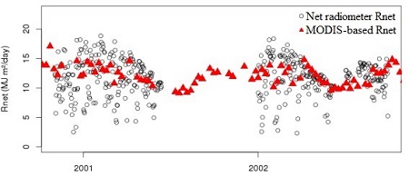
Figure. 2. Comparison of MODIS-based estimates of Rnet (every eight days) and averaged daily measurement from a net radiometer on an eddy flux tower located in Sinop, Mato Grosso (Silverio et al., 2015, Fig.S4 from the supplementary information; refer also to the companion file Rnet_calculations.pdf).
Data Acquisition, Materials, and Methods
Site description
The study area is the upper Xingu Basin in Mato Grosso, Brazil, a 176,892 km² area in southeast Amazonia that is dominated by transitional forests. The region encompasses the Xingu Indigenous Park and several adjacent indigenous reserves, which form a large (34,503 km²) mosaic of protected areas. The area outside the parks is composed of private properties, many of which have been deforested and converted to croplands or pastures (Schwartzman et al., 2013).
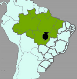
Figure 3. Map indicating the location of the upper Xingu Basin study area (image is from Silverio et al., 2015).
Methods
MODIS products (MOD43A3, MOD11A2, MOD08E3) and weather station data were used to estimate Rnet. A time series of estimated Rnet was derived for each of the 1-km grid cells.
Rnet at the land surface is the sum of net shortwave (RSnet) and net longwave (RLnet) radiation, where RSnet is incoming shortwave solar radiation (RS) minus the fraction reflected by the land surface (RS * albedo) and RLnet is the difference between incoming and outgoing longwave radiative fluxes. All Rnet parameters were estimated under all sky conditions (Silverio et al., 2015). The process to estimate Rnet is illustrated in Figure 4. The calculation of Rnet parameters is described below.
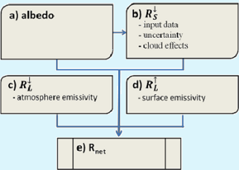
Figure. 4. Diagram of steps to calculate net radiation based on MODIS and weather station data (Silverio et al., 2015, Fig.S1 in the supplementary information; refer also to the companion file Rnet_calculations.pdf).
Calculation of Rnet Parameters
A brief summation is provided below for the calculations of the Rnet parameters. Refer to the companion file Rnet_calculations.pdf for additional details.
Albedo was calculated using the broadband black-sky and white-sky (0.25 – 4.0µm) albedo layers from the 500m MODIS albedo product MOD43A3, collection 5. The actual albedo was calculated at local noon, and atmospheric optical depth (AOD) was retrieved from MOD08 (it was assumed that AOD was homogeneous in the study area).
Downward shortwave radiation was estimated using daily data for clear sky days and implemented by the insolation function in the insol R package (Corripio 2014). Based on solar position algorithms, the model computes direct and diffuse solar irradiance perpendicular to the beam, for a given zenith angle (one-hour intervals from sunrise to sunset), Julian Day (every 8 days), altitude, and atmospheric conditions.
The input data to calculate the downward shortwave radiation was altitude (derived from a 1-km DEM; http://www.worldclim.org), air temperature, relative humidity (RH), albedo of the surrounding terrain, ozone thickness (OZ) and AOD. The air temperature and RH were estimated by kriging data from 12 weather stations belonging to the Brazilian National Meteorological Institute (INMET) (INMET 2012) (Table 2). Albedo was calculated based on MOD43A2 as explained above. OZ (at 550 nm) and AOD were from the 8-day MODIS atmospheric product (MOD08E3) (Hubanks et al., 2014). AOD was used to calculate horizontal visibility in km.
Downward longwave radiation was calculated using the Stefan-Boltzmann constant, atmosphere emissivity, air temperature from INMET weather stations, cloud emissivity and cloud temperature from the MOD08E3 product.
Upward longwave radiation was calculated using the Stefan-Boltzmann constant, land surface temperature, surface emissivity, and the downward longwave radiation.
Table 2. List of INMET weather stations used for air temperature and relative humidity (table is from Silverio et al., 2015, Table S1 in the supplementary information).
| Municipality | Lat | Lon | Altitude (m) |
|---|---|---|---|
| Caceres | -16.05 | -57.68 | 118 |
| Canarana | -13.47 | -52.27 | 430 |
| Cuiaba | -15.61 | -56.1 | 145 |
| Diamantino | -14.4 | -56.45 | 268 |
| Gleba Celeste | -12.28 | -55.29 | 415 |
| Matupa | -10.25 | -54.91 | 285 |
| Nova Xavantina | -14.7 | -52.35 | 316 |
| Padre Ricardo Remetter | -15.78 | -56.06 | 140 |
| Poxoreo | -15.83 | -54.38 | 450 |
| Rondonopolis | -16.45 | -54.56 | 284 |
| São José do Rio Claro | -13.43 | -56.71 | 350 |
| Aragarças | -15.9 | -52.23 | 345 |
Data Access
These data are available through the Oak Ridge National Laboratory (ORNL) Distributed Active Archive Center (DAAC).
Net Radiation and Albedo from MODIS for Xingu River Basin, Brazil, 2000-2012
Contact for Data Center Access Information:
- E-mail: uso@daac.ornl.gov
- Telephone: +1 (865) 241-3952
References
Corripio, J.G., 2014. insol: Solar Radiation. R package version 1.1.1 http://cran.r – project.org/web/packages/insol/index
Hubanks, P.A., R. Pincus, and X. Liang. 2014. MODIS Atmosphere: Eight-Day Global Product NASA. https://modis-atmosphere.gsfc.nasa.gov/products/eight-day
INMET 2012. Monitoramento das estações meteorológicas convencionais MAPA - Inst. Nac. Meteorol. http://www.inmet.gov.br/portal/
Macedo, M.N., R.S. DeFries, D.C. Morton, C.M. Stickler, G.L. Galford, and Y.E. Shimabukuro. 2012. Decoupling of deforestation and soy production in the southern Amazon during the late 2000s. Proc. Natl. Acad. Sci. 109 1341–6. https://doi.org/10.1073/pnas.1111374109
Schwartzman, S., A.V. Boas, K.Y. Ono, M.G. Fonseca, J. Doblas, B. Zimmerman, P. Junqueira, A. Jerozolimski, M. Salazar, R.P. Junqueira, and M. Torres. 2013. The natural and social history of the indigenous lands and protected areas corridor of the Xingu River basin. Philos. Trans. R. Soc. Lond. B. Biol. Sci. 368 20120164. https://doi.org/10.1098/rstb.2012.0164
Silverio, D.V., P.M. Brando, M.N. Macedo, P.S.A. Beck, M. Bustamante, and M.T. Coe. 2015. Agricultural expansion dominates climate changes in southeastern Amazonia: the overlooked non-GHG forcing. Environ. Res. Lett. 10 104015.https://doi.org/10.1088/1748-9326/10/10/104015