Documentation Revision Date: 2026-04-08
Dataset Version: 1
Summary
There are three data files in cloud optimized GeoTIFF (COG) format in this dataset.
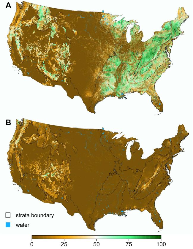
Figure 1. Probability of MOG class presence mapped at 1-ha spatial resolution. Mature (A) and old-growth (B) probabilities are shown, with the strata boundaries overlaid in black (image from Bruening et al., 2026).
Citation
Bruening, J.M., P.B. May, R.O. Dubayah, L. Wertis, C. Quinn, N. Pederson, A.H. Armstrong, and B. Poulter. 2026. Mature and Old-growth Forest Probability Maps for the Conterminous United States. ORNL DAAC, Oak Ridge, Tennessee, USA. https://doi.org/10.3334/ORNLDAAC/2498
Table of Contents
- Dataset Overview
- Data Characteristics
- Application and Derivation
- Quality Assessment
- Data Acquisition, Materials, and Methods
- Data Access
- References
Dataset Overview
This dataset contains maps of succession-related forest classes across the conterminous US: mature-forest, old-growth-forest, other-forest, and non-forest. The three forest classes have also been combined into an all-forest class. The first map type is a predicted, class presence probability map at 1-ha spatial resolution (the native mapping resolution of this study). The second map type is an aggregated set of class proportion maps at 5-km (25-km2) resolution, representing the proportions of total land area and the proportions of forest land area, for the mature-forest, old-growth-forest, and all-forest classes. The maps represent the state of U.S. forests circa 2022, the year that best matches the range of dates used for the remote sensing data, although the inventory data span slightly a wider and earlier range of years of data collection.
To derive these data, a spatial Bayesian modeling framework was developed that integrated U.S. Forest Inventory and Analysis (FIA) plot-level mature and old-growth (MOG) definitions with a stack of data layers derived from both active and passive satellite remote sensing platforms. To reduce spatial heterogeneity in predictor response relationships, CONUS was segmented into 29 strata based on forest composition and U.S. Environmental Protection Agency Level II and III ecoregions, while trying to maintain at least 100 plots in each class within any given stratum. Quadratic discriminant analysis (QDA) models were calibrated and applied independently in each stratum, with the FIA plot MOG labels as the response variable and the remote sensing data as predictors. The data that underpin both map types are a predicted distribution of class membership for each 1-ha pixel. From these posterior class distributions, presence probabilities were calculated for each class at the native mapping resolution (1-ha). These distributions were spatially aggregated to produce predicted class proportions (relative to both total land area and forested land area) for each class (5-km x 5-km resolution; 25 km2).
Related Publication
Bruening, J.M., P.B. May, R.O. Dubayah, L. Wertis, C. Quinn, N. Pederson, A.H. Armstrong, and B. Poulter. 2026. Baseline maps of U.S. mature and old-growth forests for conservation and management. Environmental Research Ecology 5:015010. https://doi.org/10.1088/2752-664X/ae5300
Related Dataset
May, P.B., R.O. Dubayah, J.M. Bruening, and G.C. Gaines. 2025. GEDI-FIA Fusion: Training Lidar Models to Estimate Forest Attributes. ORNL DAAC, Oak Ridge, Tennessee, USA. https://doi.org/10.3334/ORNLDAAC/2417
Acknowledgments
This work was supported by funding from the Global Ecosystem Dynamics Investigation (NASA contract NNL15AA03C) and from the United States Forest Service (grant 23CS11132420412).
Data Characteristics
Spatial Coverage: Conterminous US (CONUS)
Spatial Resolution: 1 ha and 25 km2
Temporal Coverage: 2022-01-01 to 2022-12-31
Temporal Resolution: One-time estimate for year circa 2022
Study Area: Latitude and longitude are given in decimal degrees.
|
Site |
Westernmost Longitude |
Easternmost Longitude |
Northernmost Latitude |
Southernmost Latitude |
|
CONUS |
-124.7614 |
-66.9295 |
49.37394 |
24.2956 |
Data File Information
There are three data files in cloud optimized GeoTIFF (.tif) format in this dataset.
Data Note: In recognition of data sovereignty of Tribal Nations and Indigenous people, map data that fall within the administrative boundaries of federally recognized Tribal lands (as designated by the U.S. Bureau of Indian Affairs) have been masked out. Tribal Nations seeking access to these masked data should contact the author.
The projection for all files is WGS 84/ NSIDC EASE-Grid 2, DATUM WGS 1984, EPSG 6933. Map units are meters.
File Descriptions
1) CONUS_mature_old_growth_probabilities_0100m.tif:
This file has five bands. Data are stored as integers. The no data value is 255. Valid range for all bands is 0-100.
The file is a 1-ha resolution (100 m x 100 m) stack of class presence probability for the 5 classes (5 bands). Values for all bands represent the probability of class presence anywhere within the 1-ha grid cell and have been rounded to the nearest integer. Here, class presence does not imply the entire pixel belongs to the target class, only that the target class is present in at least part of the cell.
- Band 1: non-forest class presence probability
- Band 2: all-forest class (combination of other-forest, mature-forest, old-growth-forest) presence probability
- Band 3: other-forest class presence probability
- Band 4: mature-forest class presence probability
- Band 5: old-growth-forest class presence probability
Bands [1, 2] sum to 100%. Bands [1, 3, 4, 5] sum to 100%. Bands [3 ,4, 5] sum to equal band [2].
2) CONUS_mature_old_growth_proportions_5000m.tif:
This file has 28 bands. The no data value is -9999.
The file contains a stack of class proportion values with 25 bands (five proportions x five metrics for each proportion), at 25-km2 (5 km x 5 km) spatial resolution. See band descriptions encoded in the GeoTIFF.
The five proportions are:
- forest proportion of total land area (bands 4-8 with five metrics listed below in order),
- mature-forest proportion of total land area (bands 9-13),
- mature-forest proportion of forest land area (bands 14-18),
- old-growth-forest proportion of total land area (bands 19-23), and
- old-growth-forest proportion of forest land area (bands 24-28)
For each of the five proportions, the five metrics are:
- lower CI bound (2.5% quantile),
- mean,
- upper CI bound (97.5% quantile),
- 95% CI range, and
- 95% CI range as a fraction of the mean
Example of five bands of data for the "mature proportion of total land area" (bands 9-13):
- mature-forest proportion of total land area: lower CI bound (2.5% quantile)
- mature-forest proportion of total land area: mean
- mature-forest proportion of total land area: upper CI bound (97.5% quantile)
- mature forest proportion of total land area: 95% CI range
- mature-forest proportion of total land area: 95% CI range as a fraction of the mean
Three additional bands in this file provide data for:
- the number of hectares that contribute to the estimate (band 1),
- a 5-km raster cell index (band 2), and
- a 50-km raster cell index (band 3)
3) CONUS_mature_old_growth_strata_0100m.tif
This file has one band stored as an integer. The no data value is 255. Valid range is 0-29.
The file shows the modeling strata boundaries in the same raster format as the 100-m probability grids, with 1-ha resolution (100-m x 100-m) grids. See Figure 2 for a strata legend and map.
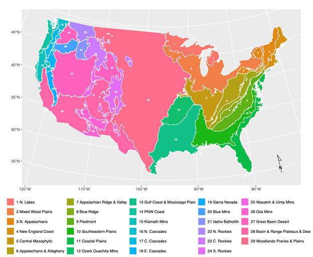
Figure 2. Strata boundaries used to calibrate and apply localized MOG models (from Bruening et al., 2026)
Application and Derivation
Mature and old-growth (MOG) forests hold significant ecological and societal value in the United States. In 2022, a presidential executive order directed the U.S. Forest Service to conduct a MOG forest inventory, and regional definitions were developed using the Forest Inventory and Analysis (FIA) system. National-scale MOG forest mapping, based on the national MOG definitions and at high spatial resolution, is essential for balancing and harmonizing MOG conservation, stewardship and management activities across government agencies and a diverse set of forest land-owners.
Quality Assessment
A 10-fold cross validation of the calibrated QDA models was performed and revealed minimal bias nationally but moderate over-prediction in some strata.
The 100-m probability surface does not have an associated uncertainty budget, and instead can be thought of as an assessment of certainty (or uncertainty) regarding class presence within each 100-m pixel. The accompanying 25-km2 mean class proportion estimates do have associated uncertainties, expressed in the form of 95% credible intervals. These intervals are directly calculated from the predicted posterior class distributions that underpin both the 100-m probability predictions and the 25-km2 proportion estimates.
Refer to Bruening et al. (2026) for an extensive discussion on the validation procedure and results, as well as the sources of uncertainty in the analysis, and how these are (and are not) reflected by the credible intervals.
Data Acquisition, Materials, and Methods
Multi-scale mature and old-growth forest (MOG) maps were derived from a Bayesian model-based enhanced forest inventory analysis that integrates Forest Inventory and Analysis (FIA) data with a stack of remote sensing predictor variables (Figure 3). The inventory data are publicly available from the U.S. FIA program and the remote sensing data are also publicly available.
Unique definitions of mature and old-growth forest classes were independently created for each FIA region using criteria based on a suite of tree- and stand-level inventory variables measured on FIA plots (Pelz et al., 2023; Woodall et al., 2023). MOG definitions were applied to FIA plots, which were spatially intersected with the remote sensing predictor variables to build the model training data. Six sources of gridded remote sensing data were considered as predictor variables:
- 30-m Landsat composite images from 2022 (Hansen et al., 2013);
- 30-m phenology time series derived from Landsat Sentinel-2 fusion Enhanced Vegetation Index (EVI) (Friedl, 2020);
- 25-m ALOS PALSAR-2 L-band SAR polarization mosaics (JAXA, 2018);
- 10-m canopy surface texture metrics derived from a 2022 Sentinel-2 EVI composite;
- 10-m canopy height model derived from GEDI-Sentinel-2 fusion (Lang et al., 2023);
- 25-m topographic variables generated from the SRTM digital elevation model (NASA JPL, 2013).
A total of twenty candidate predictor variables were generated from these six data sources. GEDI prediction data from May et al. (2025) were used to produce two GEDI variables at the FIA plot locations to be considered for model training: 1) a common proxy for maximum canopy height (RH98), and 2) vertical distribution ratio (VDR) lidar metric defined as a normalized ratio of relative heights, VDR = (RH98-RH50)/RH98. GEDI Level 2A collected between April 2019 and March 2023 (Dubayah et al., 2021) were used to make predictions of the posterior MOG class distributions with the 1ha spatial grid. GEDI data were filtered for quality using the Level 2A quality filter and additional filtering from Bruening et al. (2023). For each strata’s model calibration, a single GEDI variable was selected for inclusion as a predictor.
CONUS was segmented into strata based on forest composition and U.S. Environmental Protection Agency Level II and III ecoregions, while trying to maintain at least 100 plots in each class within any given stratum (Figure 2). This resulted in 29 unique strata, all with at least 100 mature, other, and non-forest labels (four strata contained slightly fewer than 100 old-growth labels). The quadratic discriminant analysis (QDA) models were independently calibrated and applied in each stratum. The models predicted a posterior distribution of class membership in each 1-ha land pixel, comprised of the following mutually exclusive classes: non-forest, old-growth-forest, mature-forest, and other-forest. The posterior class distributions were then used to generate two map types that enable broad-scale MOG reporting and localized forest management and conservation activities: the presence probability (1-ha resolution) and land and forest-area proportions (5-km x 5-km resolution; 25 sq-km) of each individual class. The presence probability data file also contains a band for non-forest and all-forest classes (combining the other- mature- and old-growth forest classes). These maps represent the state of U.S. forests circa 2022, the year that best matches the range of dates used for the remote sensing data. The inventory data span earlier years (approximately 2010-2023) of data collection, so this is an approximate date. For additional details, refer to Bruening et al. (2026).
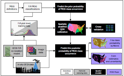
Figure 3. An overview of the workflow. Source: Bruening et al. (2026).
Data Access
These data are available through the Oak Ridge National Laboratory (ORNL) Distributed Active Archive Center (DAAC).
Mature and Old-growth Forest Probability Maps for the Conterminous United States
Contact for Data Center Access Information:
- E-mail: uso@daac.ornl.gov
- Telephone: +1 (865) 241-3952
References
Bechtold, W. A. and P.L. Patterson (editors). 2005. The enhanced forest inventory and analysis program - national sampling design and estimation procedures. Gen. Tech. Rep. SRS-80. Asheville, NC: U.S. Department of Agriculture, Forest Service, Southern Research Station. https://doi.org/10.2737/SRS-GTR-80
Bruening, J.M., P.B. May, R.O. Dubayah, L. Wertis, C. Quinn, N. Pederson, A.H. Armstrong, and B. Poulter. 2026. Baseline maps of U.S. mature and old-growth forests for conservation and management. Environmental Research Ecology 5:015010. https://doi.org/10.1088/2752-664X/ae5300
Bruening, J.M., P.B. May, J. Armston and R.O. Dubayah. 2023. Precise and unbiased biomass estimation from GEDI data and the US Forest Inventory. Frontiers in Forests and Global Change 6:1149153. https://doi.org/10.3389/ffgc.2023.1149153
Dubayah, R., M. Hofton, J. Blair, J. Armston, H. Tang, and S. Luthcke, 2021. GEDI L2A Elevation and Height Metrics Data Global Footprint Level V002. NASA Land Processes Distributed Active Archive Center. https://www.earthdata.nasa.gov/data/catalog/lpcloud-gedi02-a-002
Hansen, M.C., P.V. Potapov, R. Moore, M. Hancher, S.A. Turubanova, A. Tyukavina, D. Thau, S.V. Stehman, S.J. Goetz, T.R. Loveland, A. Kommareddy, A. Egorov, L. Chini, C.O. Justice, and J.R. G. Townshend. 2013. High-Resolution Global Maps of 21st-Century Forest Cover Change. Science 342:850–853. https://doi.org/10.1126/science.1244693, https://glad.earthengine.app/view/global-forest-change
Friedl, M. 2021. MuSLI Multi-Source Land Surface Phenology Yearly North America 30 m V011. NASA Land Processes Distributed Active Archive Center. https://www.earthdata.nasa.gov/data/catalog/lpcloud-mslsp30na-011
JAXA. 2018.Global PALSAR-2/PALSAR/JERS-1 Mosaic and Forest / Non-forest Map. https://www.eorc.jaxa.jp/ALOS/en/dataset/fnf_e.htm, https://www.eorc.jaxa.jp/ALOS/en/palsar_fnf/data/index.htm
Lang, N., W. Jetz, K. Schindler, and J.D. Wegner. 2023. A high-resolution canopy height model of the earth. Nature Ecology & Evolution 7:1778–1789. https://doi.org/10.1038/s41559-023-02206-6
May, P.B., R.O. Dubayah, J.M. Bruening, and G.C. Gaines. 2025. GEDI-FIA Fusion: Training Lidar Models to Estimate Forest Attributes. ORNL DAAC, Oak Ridge, Tennessee, USA. https://doi.org/10.3334/ORNLDAAC/2417
NASA JPL. 2013. NASA Shuttle Radar Topography Mission Global 3 arc second. NASA Land Processes Distributed Active Archive Center. https://doi.org/10.5067/MEASURES/SRTM/SRTMGL3.003
Pelz, K.A., G. Hayward, A.N. Gray, E.M. Berryman, C.W. Woodall, A. Nathanson, and N.A. Morgan. 2023. Quantifying old-growth forest of United States Forest Service public lands. Forest Ecology and Management 549:121437. https://doi.org/10.1016/j.foreco.2023.121437
Woodall, C.W., A.G. Kamoske, G.D. Hayward, T.M. Schuler, C.A. Hiemstra, M. Palmer, and A.N. Gray. 2023. Classifying mature federal forests in the united states: The forest inventory growth stage system. Forest Ecology and Management 546:121361 https://doi.org/10.1016/j.foreco.2023.121361