Documentation Revision Date: 2021-05-20
Dataset Version: 1
Summary
In preparation for the sixth phase of the Coupled Model Intercomparison Project (CMIP6), a new set of global gridded land use forcing data (i.e., the LUH2 dataset) was developed as input for CMIP6 simulations. The LUH2 dataset builds upon past work from CMIP5 and includes updated inputs, higher spatial resolution, more detailed land-use transitions, and the addition of important agricultural management layers. This LUH2 dataset has been updated annually to provide required input (i.e., the LUH2-GCB datasets) to land models in the annual GCB assessments. For GCB 2019, a more significant update to LUH2 was produced, LUH2-GCB2019, to take advantage of new data inputs that corrected cropland and grazing areas in the globally important region of Brazil, as far back as 1950. From 1951–2012 the LUH2-GCB2019 dataset begins to diverge from the version of LUH2 used for CMIP6, with peak differences in Brazil in the year 2000 for grazing land (difference of 100,000 km2) and in the year 2009 for cropland (difference of 77,000 km2), along with significant sub-national reorganization of agricultural land-use patterns within Brazil (Chini et al., 2021).
There are 3 data files in netCDF-4 (*.nc4) format and 1 companion file included in this dataset.
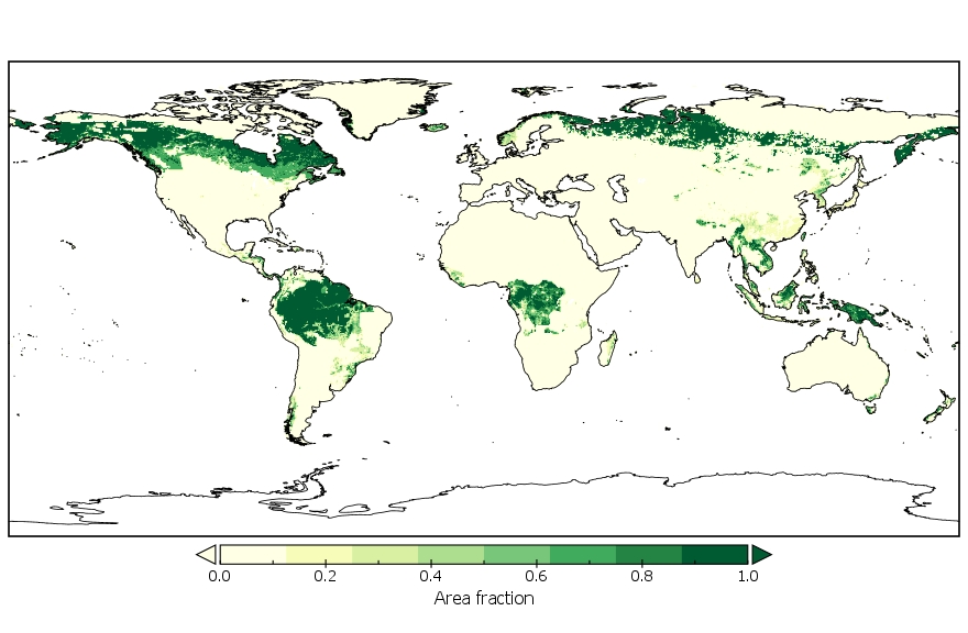
Figure 1. Area fraction of each grid cell of primary lands covered by forests in the year 2000. Source: states.nc4
Citation
Chini, L.P., G.C. Hurtt, R. Sahajpal, S. Frolking, K.K Goldewijk, S. Sitch, J. Pongratz, B. Poulter, L. Ma, and L. Ott. 2021. LUH2-GCB2019: Land-Use Harmonization 2 Update for the Global Carbon Budget, 850-2019. ORNL DAAC, Oak Ridge, Tennessee, USA. https://doi.org/10.3334/ORNLDAAC/1851
Table of Contents
- Dataset Overview
- Data Characteristics
- Application and Derivation
- Quality Assessment
- Data Acquisition, Materials, and Methods
- Data Access
- References
Dataset Overview
This dataset, referred to as LUH2-GCB2019, includes 0.25-degree gridded, global maps of fractional land-use states, transitions, and management practices for the period 0850-2019. The LUH2-GCB2019 dataset is an update to the previous Land-Use Harmonization Version 2 (LUH2-GCB) datasets prepared as required input to land models in the annual Global Carbon Budget (GCB) assessments, including land-use change data relating to agricultural expansion, deforestation, wood harvesting, shifting cultivation, afforestation, and crop rotations. Compared with previous LUH2-GCB datasets, the LUH2-GCB2019 takes advantage of new data inputs that corrected cropland and grazing areas in the globally important region of Brazil, as far back as 1950. LUH2-GCB datasets are used by bookkeeping models and Dynamic Global Vegetation Models (DGVMs) for the GCB.
In preparation for the sixth phase of the Coupled Model Intercomparison Project (CMIP6), a new set of global gridded land use forcing data (i.e., the LUH2 dataset) was developed as input for CMIP6 simulations. The LUH2 dataset builds upon past work from CMIP5 and includes updated inputs, higher spatial resolution, more detailed land-use transitions, and the addition of important agricultural management layers. This LUH2 dataset has been updated annually to provide required input (i.e., the LUH2-GCB datasets) to land models in the annual GCB assessments. For GCB 2019, a more significant update to LUH2 was produced, LUH2-GCB2019, to take advantage of new data inputs that corrected cropland and grazing areas in the globally important region of Brazil, as far back as 1950. From 1951–2012 the LUH2-GCB2019 dataset begins to diverge from the version of LUH2 used for CMIP6, with peak differences in Brazil in the year 2000 for grazing land (difference of 100,000 km2) and in the year 2009 for cropland (difference of 77,000 km2), along with significant sub-national reorganization of agricultural land-use patterns within Brazil (Chini et al., 2021).
Related Publications
Chini, L., G. Hurtt, R. Sahajpal, S. Frolking, K. Klein Goldewijk, S. Sitch, R. Ganzenmüller, L. Ma, L. Ott, J. Pongratz, and B. Poulter. 2021. Land-use harmonization datasets for annual global carbon budgets. In review at Earth System Science Data Discussions. https://doi.org/10.5194/essd-2020-388
Hurtt, G.C., L. Chini, R. Sahajpal, S. Frolking, B.L. Bodirsky, K. Calvin, J.C. Doelman, J. Fisk, S. Fujimori, K. Klein Goldewijk, T. Hasegawa, P. Havlik, A. Heinimann, F. Humpenöder, J. Jungclaus, J.O. Kaplan, J. Kennedy, T. Krisztin, D. Lawrence, P. Lawrence, L. Ma, O. Mertz, J. Pongratz, A. Popp, B. Poulter, K. Riahi, E. Shevliakova, E. Stehfest, P. Thornton, F.N. Tubiello, D.P. van Vuuren, and X. Zhang. 2020. Harmonization of global land use change and management for the period 850–2100 (LUH2) for CMIP6. Geoscientific Model Development 13:5425–5464. https://doi.org/10.5194/gmd-13-5425-2020
Related Datasets
Chini, L.P., G.C. Hurtt, and S. Frolking. 2014. Harmonized Global Land Use for Years 1500-2100, V1. ORNL DAAC, Oak Ridge, Tennessee, USA. https://doi.org/10.3334/ORNLDAAC/1248
- This dataset, LUH1, provides fractional land use and land cover patterns and annual land-use transitions for the period 1500-2100 for the globe at 0.5-degree (~50 km) spatial resolution.
Chini, L.P., G.C. Hurtt, R. Sahajpal, S. Frolking, K. Frieler, A. Popp, B. Bodirsky, F. Humpenoeder, M. Stevanovic, K. Calvin, S. Ostberg, L. Warszawski, and J. Volkholz. 2020. LUH2-ISIMIP2b Harmonized Global Land Use for the Years 2015-2100. ORNL DAAC, Oak Ridge, Tennessee, USA. https://doi.org/10.3334/ORNLDAAC/1721
- This dataset, LUH2-ISIMIP2b, was specially created using the LUH2 technology.
Wei, Y., Shishi Liu, D.N. Huntzinger, A.M. Michalak, N. Viovy, W.M. Post, C.R. Schwalm, K. Schaefer, A.R. Jacobson, C. Lu, H. Tian, D.M. Ricciuto, R.B. Cook, J. Mao, and X. Shi. 2014. NACP MsTMIP: Global and North American Driver Data for Multi-Model Intercomparison. ORNL DAAC, Oak Ridge, Tennessee, USA. https://doi.org/10.3334/ORNLDAAC/1220
- This dataset demonstrates how LUH can inform other models.
Acknowledgments
This project received funding from NASA’s Terrestrial Ecology (grant NNX13AK84A) and Interdisciplinary Science (grant 80NSSC17K0348) programs.
Data Characteristics
Spatial Coverage: Global
Spatial Resolution: 0.25-degree grid cells
Temporal Coverage: 0850-01-01 to 2019-12-31
Temporal Resolution: Annual
Site Boundaries: Latitude and longitude are given in decimal degrees.
| Site | Westernmost Longitude | Easternmost Longitude | Northernmost Latitude | Southernmost Latitude |
|---|---|---|---|---|
| Global land areas | -180 | 180 | 90 | -90 |
Data File Information
There are 3 data files in netCDF-4 (*.nc4) format and 1 companion file included in this dataset. Each data file is an annual time series covering the period 0850–2019 (1170 time steps).
Table 1. File names and descriptions. The units provided here are applicable to the majority of variables.
| File Name | Units | Description |
|---|---|---|
| LUH2_GCB2019_management.nc4 | fraction of crop area | Proportion of cells receiving specific agricultural and forest management practices |
| LUH2_GCB2019_states.nc4 | fraction of grid cell | Proportion of cell covered by land-use states |
| LUH2_GCB2019_transitions.nc4 | fraction per year | Rate of change from land-use state X to state Y during the annual time step (a probability) |
| netcdf_header_info.txt | Metadata for each data file is provided as a companion file |
Table 2. Variables and descriptions for each file. The units for all variables are "fraction" unless listed in parentheses after the description.
| Variable | Description |
|---|---|
| LUH2_GCB2019_states.nc4 | |
| c3ann | C3 annual crops |
| c3nfx | C3 nitrogen-fixing crops |
| c3per | C3 perennial crops |
| c4ann | C4 annual crops |
| c4per | C4 perennial crops |
| pastr | managed pasture |
| primf | forested primary land |
| primn | non-forested primary land |
| range | rangeland |
| secdf | potentially forested secondary land |
| secdn | potentially non-forested secondary land |
| secma | secondary mean age (years) |
| secmb | secondary mean biomass carbon density (kg m-2) |
| urban | urban land |
| LUH2_GCB2019_transitions.nc4 | |
| primf_bioh | wood harvest biomass from primary forest, total from grid cell (kg) |
| primf_harv | wood harvest area from primary forest |
| secmf_bioh | wood harvest biomass from secondary mature forest, total from grid cell (kg) |
| secmf_harv | wood harvest area from secondary mature forest |
| secnf_bioh | wood harvest biomass from secondary non-forest, total from grid cell (kg) |
| secnf_harv | wood harvest area from secondary non-forest |
| secyf_bioh | wood harvest biomass from secondary young forest, total from grid cell (kg) |
| secyf_harv | wood harvest area from secondary young forest |
| stateX_to_stateY | There are 108 variables not listed here that denote the transition rate from land-use state X to state Y. See companion file netcdf_header_info.txt for descriptions. |
| LUH2_GCB2019_management.nc4 | |
| combf | commercial biofuels fraction of wood harvest biomass carbon |
| crpbf_c3ann | C3 annual crops fraction of crop type area grown as biofuels |
| crpbf_c3nfx | C3 nitrogen-fixing crops fraction of crop type area grown as biofuels |
| crpbf_c3per | C3 perennial crops fraction of crop type area grown as biofuels |
| crpbf_c4ann | C4 annual crops fraction of crop type area grown as biofuels |
| crpbf_c4per | C4 perennial crops fraction of crop type area grown as biofuels |
| fertl_c3ann | fertilization rate for C3 annual crops (kg ha-1 yr-1) |
| fertl_c3nfx | fertilization rate for C3 nitrogen-fixing crops (kg ha-1 yr-1) |
| fertl_c3per | fertilization rate for C3 perennial crops (kg ha-1 yr-1) |
| fertl_c4ann | fertilization rate for C4 annual crops (kg ha-1 yr-1) |
| fertl_c4per | fertilization rate for C4 perennial crops (kg ha-1 yr-1) |
| fharv_c3per | fraction of C3 perennial crops biomass carbon harvested annually |
| fharv_c4per | fraction of C4 perennial crops biomass carbon harvested annually |
| flood | flooded fraction of C3 annual crop area (e.g. for paddy rice) |
| fulwd | fuelwood fraction of wood harvest biomass carbon |
| irrig_c3ann | irrigated fraction of C3 annual crops |
| irrig_c3nfx | irrigated fraction of C3 nitrogen-fixing crops |
| irrig_c3per | irrigated fraction of C3 perennial crops |
| irrig_c4ann | irrigated fraction of C4 annual crops |
| irrig_c4per | irrigated fraction of C4 perennial crops |
| rndwd | industrial roundwood fraction of wood harvest biomass carbon |
Application and Derivation
Land-use changes are important for understanding historical changes in climate and for understanding natural versus anthropocentric effects. New Earth System Models (ESMs) can combine the effects of land-use changes with the influence of greenhouse gas emissions. The LUH Version 1(LUH1; Chini et al., 2014) dataset has been extensively used in climate simulations by CMIP5 (https://pcmdi.llnl.gov/mips/cmip5/). A new generation, LUH2, dataset (Hurtt et al., 2020) was later developed and used as input for CMIP6 simulations. The LUH2 dataset has then been updated annually to provide required input to land models in the annual GCB assessments. LUH2-GCB2019 (this dataset) is an update to the previously released LUH2 datasets and takes advantage of new data inputs that corrected cropland and grazing areas in the globally important region of Brazil, as far back as 1950 (Chini et al., 2021). Data files of the LUH2-GCB2019 dataset have improved compliance to NetCDF Climate and Forecast Metadata Conventions (http://cfconventions.org/).
Quality Assessment
A sensitivity analysis was performed to evaluate the importance of input datasets and parameters in this model. For each input dataset, simulations with and without those inputs were conducted; only a single factor was varied at once. A total of 1,664 land-use scenarios were examined. Details of this analysis and its results are provided in Hurtt et al. (2011) and Chini et al. (2021). Table 2 (above) provides a list of model factors and simulation case studies, and Figure 8 of Hurtt et al. (2011) provides detailed results of the sensitivity analysis.
Key findings from Hurt et al. (2020) and Chini et al. (2021) indicate that shifting cultivation, wood harvesting, and simulation start date all strongly affect the estimated secondary land area, secondary land age, and related carbon fluxes. The Global Land-use Model (GLM) approach relied on multiple model inputs and factors. Therefore, results must be considered uncertain and highly dependent on the inputs and assumptions used. Overall, uncertainty is expected to be highest in the distant past and future, and at high spatial resolutions.
Data Acquisition, Materials, and Methods
Land Use Harmonization Generation 1
The Land-Use Harmonization (LUH) project seeks to produce harmonized historical reconstructions of land use with modern assessments for use with global scale models of climate change. These reconstructions require integrating historical maps of agriculture and urban land uses (e.g., HYDE database; Klein Goldewijk et al., 2011) with estimates of forest harvest and shifting cultivation. Global scale, gridded data on land use can improve understanding of the earth-climate system; however, there has been a diversity of approaches used for historical reconstructions among Integrated Assessment Models and Earth Systems Models. The LUH datasets result from efforts to better account for the land-use change in global carbon budgets.
The methods used to produce the LUH version 1 dataset is described in Hurt et al. (2011). The GLM framework was used to integrate data from a variety of sources for the reconstruction of historical land uses since 1500 and to model future changes through 2100 (Hurtt et al., 2006). The GLM simulates land-use transitions for every grid cell at each time step using time-specific information on current land use state, agricultural and forest management practices, socioecological factors, and drivers of change such as shifting cultivation and time of land in agricultural uses (Hurtt et al., 2011).
Land Use Harmonization Generation 2
The new generation, LUH2, dataset brings together multiple datasets at multiple different spatial and temporal scales and harmonizes them to produce a single dataset of global, gridded land-use and all associated land-use transitions, annually for the years 0850-2100, in a consistent format for use in ESMs. LUH2 builds upon past work from CMIP5 and includes updated inputs, higher spatial resolution, more detailed land-use transitions, and the addition of important agricultural management layers (Hurtt et al., 2011).
The LUH2-GCB2019 dataset provided here is an update to the previously released LUH2 datasets (LUH2 v1.0h, LUH2 v2h, LUH2-GCB2017, LUH2-GCB2018) (Chini et al., 2021). LUH2-GCB2019 extends the historical period to 0850 and improves spatial resolution from 0.5-degree to 0.25-degree grid cells. It also harmonizes multiple datasets at multiple different spatial and temporal scales to produce a single dataset of global, gridded land-use and all associated land-use transitions (Chini et al., 2021).
LUH2-GCB2019 includes the fractional area of 12 land-use types in each grid cell along with age and biomass density of secondary land cover. The 12 land-use types (i.e., states) include cropland (subdivided into C3 annuals, C4 annuals, C3 perennials, C4 perennials, and C3 N-fixers), grazing land (subdivided into managed pasture and rangeland), urban land, primary land (forested and non-forested), and secondary land (potentially forested and potentially non-forested). It includes agricultural management practices, including fertilizer applications (Chini et al., 2021).
LUH2-GCB2019 incorporates updates to historical HYDE land-use inputs and updated spatial patterns of nitrogen-fixing crops and biofuel crops. Estimates for the historical period (0850-2015) were based on the HYDE 3.2 dataset (Klein Goldewijk et al., 2017) and the FAO (2016) wood harvest data. HYDE 3.2 includes gridded estimates of cropland, grazing lands, and urban areas. Discrepancies in cropland estimates for Brazil were corrected, and wood harvest data from FAO for 2015-2019 were added. Details of these updates are available in Chini et al. (2021).
Data Access
These data are available through the Oak Ridge National Laboratory (ORNL) Distributed Active Archive Center (DAAC).
LUH2-GCB2019: Land-Use Harmonization 2 Update for the Global Carbon Budget, 850-2019
Contact for Data Center Access Information:
- E-mail: uso@daac.ornl.gov
- Telephone: +1 (865) 241-3952
References
Chini, L.P., G.C. Hurtt, and S. Frolking. 2014. Harmonized Global Land Use for Years 1500-2100, V1. ORNL DAAC, Oak Ridge, Tennessee, USA. https://doi.org/10.3334/ORNLDAAC/1248
Chini, L., G. Hurtt, R. Sahajpal, S. Frolking, K. Klein Goldewijk, S. Sitch, R. Ganzenmüller, L. Ma, L. Ott, J. Pongratz, and B. Poulter. 2021. Land-use harmonization datasets for annual global carbon budgets. In review at Earth System Science Data Discussions. https://doi.org/10.5194/essd-2020-388
FAO. 2016. FAOSTAT Database. Food and Agriculture Organization of the United Nations, Rome, Italy. http://www.fao.org/faostat/
Hurtt, G.C., S. Frolking, M.G. Fearon, B. Moore, E. Shevliakova, S. Malyshev, S.W. Pacala, and R.A. Houghton. 2006. The underpinnings of land-use history: three centuries of global gridded land-use transitions, wood-harvest, and resulting secondary lands. Global Change Biology 12:1208-1229. https://doi.org/10.1111/j.1365-2486.2006.01150.x
Hurtt, G.C., L.P. Chini, S. Frolking, R.A. Betts, J. Feddema, G. Fischer, J.P. Fisk, K. Hibbard, R.A. Houghton, A. Janetos, C.D. Jones, G. Kindermann, T. Kinoshita, K. Klein Goldewijk, K. Riahi, E. Shevliakova, S. Smith, E. Stehfest, A. Thomson, P. Thornton, D.P. van Vuuren, Y.P. Wang. 2011. Harmonization of land-use scenarios for the period 1500–2100: 600 years of global gridded annual land-use transitions, wood harvest, and resulting secondary lands. Climatic Change 109:117-161. https://doi.org/10.1007/s10584-011-0153-2
Hurtt, G.C., L. Chini, R. Sahajpal, S. Frolking, B.L. Bodirsky, K. Calvin, J.C. Doelman, J. Fisk, S. Fujimori, K. Klein Goldewijk, T. Hasegawa, P. Havlik, A. Heinimann, F. Humpenöder, J. Jungclaus, J.O. Kaplan, J. Kennedy, T. Krisztin, D. Lawrence, P. Lawrence, L. Ma, O. Mertz, J. Pongratz, A. Popp, B. Poulter, K. Riahi, E. Shevliakova, E. Stehfest, P. Thornton, F.N. Tubiello, D.P. van Vuuren, and X. Zhang. 2020. Harmonization of global land use change and management for the period 850–2100 (LUH2) for CMIP6. Geoscientific Model Development 13:5425–5464. https://doi.org/10.5194/gmd-13-5425-2020
Klein Goldewijk K, A. Beusen, G. van Drecht, and M. de Vos. 2011. The HYDE 3.1 spatially explicit database of human induced land use change over the past 12,000 years. Global Ecology & Biogeography 20:73–86. https://doi.org/10.1111/j.1466-8238.2010.00587.x
Klein Goldewijk, K., A. Beusen, J. Doelman, and E. Stehfest. 2017. Anthropogenic land-use estimates for the Holocene - 1110
HYDE 3.2. Earth System Science Data 9:927-953. https://doi.org/10.5194/essd-9-927-2017