Documentation Revision Date: 2024-01-24
Dataset Version: 1
Summary
This is a preprint dataset. The QA of the data files and this dataset documentation are in progress.
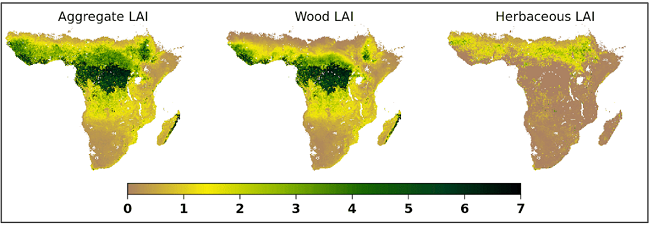
Figure 1. Leaf area index (LAI).
Citation
Kahiu, N., and J.Y. Anchang. 2024. Aggregate, woody and herbaceous leaf area index for Africa. ORNL DAAC, Oak Ridge, Tennessee, USA. https://doi.org/10.3334/ORNLDAAC/2325
Table of Contents
- Dataset Overview
- Data Characteristics
- Application and Derivation
- Quality Assessment
- Data Acquisition, Materials, and Methods
- Data Access
- References
Dataset Overview
Project: Vegetation Collection
The ORNL DAAC compiles, archives, and distributes data on vegetation from local to global scales. Specific topic areas include: belowground vegetation characteristics and roots, vegetation biomass, fire and other disturbance, vegetation dynamics, land cover and land use change, vegetation characteristics, and NPP (Net Primary Production) data.
Acknowledgement
This research was funded by the NASA-SERVIR Advanced Science Team program; PEER Cycle 8, grant number 80NSSC20K0162.
Data Characteristics
Study Areas: Sub-Saharan Africa
Spatial Resolution: 500 m
Temporal Coverage: 2002-07-01 to 2021-12-31
Temporal Resolution: 8-days
Data file information
The data files are in NetCDF (.nc) format. The data consists of leaf area index data from Moderate Resolution Imaging Spectroradiometer (MODIS) Level 4, and Leaf Area Index (LAI) product (MCD15A2H Version 6.1) available every 8-days at 500-m pixel size. From the native MODIS LAI, the data were processed further to generate three layers including: a smoothed and gap filled LAI layer referred to as aggregate leaf area index, denoted as LAIA; and two additional layers processed using an algorithm developed in Kahiu and Hanan (2018) to separate woody LAI (LAIW, tree and shrubs), and herbaceous LAI (LAIH, grass and forbs).
Table 1. Filenames and descriptions.
|
File Name |
Description |
|
Example: MCD15A2H.A2003001.h16v07.061.partitionedLAI.nc |
MODISProduct.Date.Tile.Version.Product.FileEextension |
|
Each file contains the following: |
|
E.g. MCD15A2H.A2003001.h16v07.061.smoothLAI.tif |
Original MODIS LAI data after gap filling and smoothing; referred to aggregate LAI denoted as (LAIA) |
E.g. MCD15A2H.A2003001.h16v07.061.woodLAI.tif |
Separated woody LAI estimates derived from aggregate LAI denoted as (LAIW) |
|
Separated herbaceous LAI estimates derived from aggregate LAI denoted as (LAIH) |
|
NB: All the files correspond to the MODIS Tiling system and Naming convention for MCD15A2H Version 6.1 |
|
Application and Derivation
These data are suitable for numerous applications. By separating the effect of seasonal and long-term changes in woody and herbaceous leaf area, this product enables more precise global land surface and Earth system models. Additionally, it enhances ecological models, including those focused on fire occurrences and herbivore distribution. Furthermore, it contributes to refining estimates for drought monitoring and facilitates the development of index-based models for drought risk transfer models.
Quality Assessment
We compared MODIS partitioned LAI with in situ measurements, showing an overall agreement of approximately 50%. However, there's a tendency to underestimate LAIW in regions with higher in situ LAIW. These discrepancies may arise from scale differences between in situ data and MODIS 500 m -1000 m pixel size, as well as limitations in the generalized allometric equations used for partitioning. To enhance accuracy, we are developing allometries that differentiate tree functional groups or bioclimatic regions. As more data on allometry models become available, we expect improved validation results in future LAI retrievals.
Data Acquisition, Materials, and Methods
The methods involved partitioning of the MODIS aggregate LAI (LAIA) into separate woody (LAIW) and herbaceous (LAIH) constituents in both drought seasonal savannas and moist tropical forests of Sub-Saharan Africa (SSA). In our analysis, we use an allometric relationship describing the variation in peak within-canopy woody LAI of dominant tree species across precipitation gradients, coupled with independent estimates of woody canopy cover, to constrain seasonally changing woody LAI (LAIW). The data covers epoch 2002 to 2021 available every 8-days at 500 m spatial resolution.
Further details on the data and processing methods are detailed in Kahiu and Hanan (2018) .
Data Access
These data are available through the Oak Ridge National Laboratory (ORNL) Distributed Active Archive Center (DAAC).
Aggregate, woody and herbaceous leaf area index for Africa
Contact for Data Center Access Information:
- E-mail: uso@daac.ornl.gov
- Telephone: +1 (865) 241-3952
References
Kahiu, N., and N.P. Hanan. 2018. Estimation of Woody and Herbaceous Leaf Area Index in Sub-Saharan Africa Using MODIS Data. Journal of Geophysical Research: Biogeosciences, 123(1), 3–17. https://doi.org/10.1002/2017JG004105