Documentation Revision Date: 2025-03-06
Dataset Version: 1.1
Summary
This dataset consists of one file in portable document format (PDF).
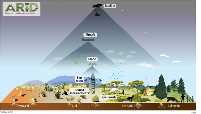
Figure 1. ARID will vastly improve the quantitative and predictive understanding of Earth's drylands, using a nested approach that coordinates in-situ measurements, existing and new research networks, and with drone and aircraft data that harmonize with and inform satellite observations.
Citation
Reed, S.C., A.F. Feldman, N.P. Hanan, D.J.P. Moore, D.S. Ojima, W.K. Smith, K. Wessels, C. Amaral, F. Babst, J. Biederman, M.E. Litvak, N. MacBean, B. Poulter, R.L. Scott, A. Babst-Kostecka, Z. Fu, J.K. Green, R.F. Kokaly, R.J. Swap, S.P. Serbin, C.J. Tucker, L. Wang, J.D. Watts, G.M. Wolfe, A. Flores, J.R. Leaf, R. Washington-Allen, K. Prentice, E. Kachergis, J. Reyes, J. Ryan, M. SanClements, H. Loescher, A. Leidner, T. Swetnam, and B. Cook. 2025. The ARID Scoping Study Final Report. ORNL DAAC, Oak Ridge, Tennessee, USA. https://doi.org/10.3334/ORNLDAAC/2408
Table of Contents
- Dataset Overview
- Data Characteristics
- Application and Derivation
- Quality Assessment
- Data Acquisition, Materials, and Methods
- Data Access
- References
- Dataset Revisions
Dataset Overview
This dataset provides the final report from the Adaptation and Response in Drylands (ARID) scoping study. ARID is one of the two scoping studies funded by NASA in 2023 to identify the scientific questions and develop the initial study design and implementation concept for a new NASA Terrestrial Ecology field campaign. This report emphasizes a prioritized research agenda and an initial implementation plan, focusing on the western U.S. to deepen our understanding of national dryland processes and resources. ARID is also leveraging an extensive network of international sites and collaborators in Africa, Australia, Mexico, and South America. This global approach facilitates the evaluation, monitoring, and forecasting of drylands worldwide, ensuring a coordinated effort to address and inform solutions for the challenges facing these critical ecosystems. ARID will use cutting-edge approaches to address four Science Themes: 1) Climate Variability and Drought, 2) Ecosystem Structure, Function, and Biodiversity, 3) Carbon Cycle Interannual Variability and Long-Term Trends, and 4) Social-Ecological Systems. The scoping study performed extensive outreach, conducting over 160 meetings and events with hundreds of scientists and decision-makers across six continents, which translated to the ARID science plan being co-created with a wide range of contributors and perspectives, including remote sensing, modeling, and dryland scientists; Tribal Nations; and a range of U.S. federal entities. This report outlines a targeted plan to deploy field and NASA airborne instruments to vastly augment data derived from satellite observations that, when joined, will substantially advance quantification of drylands' large and changing role in the U.S. and in the Earth system.
Related Dataset:
Ordway, E.M., M.M. Keller, M. Longo, R. Negron-Juarez, Y. Feng, H. Stouter, I.N. Rivera, A. Alencar, A. Bey, R.K. Braghiere, A. Cardoso, K.D. Chadwick, J.D Fuentes, R. Eckert, L. Fatoyinbo, A. Ferraz, L. Guild, M.S. Johnson, E. Kane, L.S. Koutika, Y. Li, J. Liu, I.B. Mccubbin, F. Meunier, C.E. Miller, H.C. Muller-Landau, T. Nkuintchua, M. Nunes, L.B.S. Takougoum, M.J. Santos, F.D. Schneider, M. Simard, B. Sonke, C. Terrer, M. von Essen, M.Y. Wong, S.R. Worden, X. Xiao, V. Zaunbrecher, M. Bauters, P. Boeckx, J. Bowen, I. Chiari, O. Csillik, G. Diez, M. Doroso, D.D. Pugley, W. Hubau, A.E. Ochoa, E. Gora, A. Hoyt, J.C. Jintiach, V. Maqque, C. Perryman, Z. Pierrat, L. Saraiva, D. Singh, I. Tanshi, J. Thompson, and H. Verbeeck. 2025. The PANGEA Scoping Study Final Report. ORNL DAAC, Oak Ridge, Tennessee, USA. https://doi.org/10.3334/ORNLDAAC/2405
Acknowledgements:
ARID was funded by the NASA Terrestrial Ecology Program.
We offer our deep gratitude to all those involved in ARID’s scoping activities, who dedicated their time and expertise to improve ARID and its ability to make dramatic advances in our understanding of and capacity to support decisions for Earth’s drylands.
Any use of trade, firm, or product names is for descriptive purposes only and does not imply endorsement by the U.S. Government.
Data Characteristics
There is one file with this dataset in PDF format: ARID_Scoping_White_Paper_V1.1.pdf. The pdf provides the scientific justification, key questions, study design, and implementation concept for a new NASA Terrestrial Ecology field campaign focused on drylands.
Application and Derivation
The ARID framework was co-created by a large and diverse community of scientists, data users, and practitioners who together informed an actionable study design to dramatically advance our understanding and capacity to monitor, forecast, and inform decisions for Earth’s rapidly changing drylands. The scoping study provides a rationale for the importance of better understanding Earth’s dryland ecosystems, poses key scientific questions around the foundational interconnected research themes, offers a conceptual campaign framework to address them, and underscores the necessary role of NASA in achieving these important goals. ARID is an international campaign, outlining strong research needs, partnerships, and synergistic field campaign initiatives for Australia, northern Mexico, southern Africa, and South America. At the same time there is a significant focus on the United States (U.S.) due the strong national need for actionable dryland science. Drylands are of particular importance to U.S. national resources and security, covering ~83% of the western U.S. and under stress from the ongoing North American megadrought. By investigating how ecosystems are responding to climate change, weather extremes, management practices, and land-use change, ARID aims to better understand the shifting role of drylands in the Earth System, including global carbon and water cycles, thereby advancing our predictive capacity to support end-user decision making and improve forecasts of current and future feedback to climate change at the global scale. The ARID scoping study provides a research plan consistent with the mandate of NASA Earth Science Division's Earth System Observatory to "create a 3D, holistic view of Earth, from bedrock to atmosphere." Furthermore, ARID is strongly aligned with NASA's Earth Science to Action (ES2A) strategy, which has the exciting goal of innovating and collaborating across multiple research and end-user sectors “to explore and understand the Earth system, make new discoveries, and enable solutions for the benefit of all”.
What would ARID accomplish?
- Advance our foundational understanding of how drylands function and contribute to the U.S. and the Earth System.
- Transform our capacity to monitor and predict food production, vegetation structure and composition, water availability, and fires, which would directly inform decision-support for decision-makers.
- Revolutionize multi-scale, multi-sensor remote sensing of dryland patterns and processes, enhancing our capacity to use current and future NASA satellite observations in drylands.
- Leverage and complement existing investments and research in drylands with the goal of improving the assessment and management options for dryland natural resources.
- Train the next generation of Earth System scientists through multidisciplinary education, training, and network building.
- Develop novel data products and tools to inform science-based decision-making toward sustaining dryland ecosystems for future generations.
- Build a collaborative international community focused on transdisciplinary dryland science for sustained study of dryland ecosystems.
Refer to the file ARID_Scoping_White_Paper_V1.1.pdf for details.
Quality Assessment
Not Applicable.
Data Acquisition, Materials, and Methods
The ARID campaign would use NASA's extensive current (e.g., ECOSTRESS, EMIT, SMAP, Landsat) and future (e.g., NISAR, SBG, and Landsat Next) satellites in conjunction with a dedicated multi-scale field campaign using NASA airborne assets (e.g., AVIRIS, UAVSAR, and MASTER) and ground measurements. With these spaceborne, aircraft, and field sampling capabilities across scales, NASA is the only agency positioned to bring the science and end-user communities together to address the ARID campaign’s four interrelated science themes and overarching questions:
- Climate Variability and Drought: How are climate extremes like droughts, heatwaves, and large rain pulses impacting dryland systems and interacting with fire regimes, land cover change, and land-atmosphere interactions?
- Ecosystem Structure, Function, and Biodiversity: What are the main mechanisms driving the spatiotemporal distributions of dryland structure, function, and biodiversity, and how vulnerable are these ecosystem components?
- Carbon Cycle Interannual Variability and Long-Term Trends: What is the contribution of drylands to the mean, trend, and interannual variability of global terrestrial carbon uptake, what drives these patterns, and what can we expect from them in the future?
- Social-Ecological Systems: What are the consequences of changes in drylands for social-ecological systems, and what management options can sustain the ecosystem services supporting lives, livelihoods, and national security in the face of change?
A core portion of ARID is proposed to be carried out in the western U.S., taking advantage of natural gradients of aridity, practitioner interest, and the opportunity to leverage existing NASA data, partner airborne campaigns, and ground assets. The domestic focal areas include the southwestern U.S., Great Plains, Mountain West, and Great Basin. While the U.S. focal domain represents a large portion of the aridity range of global drylands, international sites are necessary to address science questions at a global scale and to represent the diversity of dryland ecosystems across which models and hypotheses are tested. Candidate international sites were selected based on queried community needs, scientific track record, and assets of local partners (long-term field data and instrumentation), as well as logistical feasibility, dependability of plans, and safety and security. Candidate sites are located in southern Africa, northern Mexico, Australia, and the Cerrado and Caatinga regions of South America. Leading international partner institutions (e.g., TERN - Australia; SAEON - South Africa) are members of Global Ecosystem Research Infrastructure (GERI), along with the U.S.’s NEON, where they coordinate research on global issues such as ecological drought.
Refer to the file ARID_Scoping_White_Paper_V1.1.pdf for details.
Data Access
These data are available through the Oak Ridge National Laboratory (ORNL) Distributed Active Archive Center (DAAC).
The ARID Scoping Study Final Report
Contact for Data Center Access Information:
- E-mail: uso@daac.ornl.gov
- Telephone: +1 (865) 241-3952
References
None.
Dataset Revisions
| Version | Release Date | Revision Notes |
|---|---|---|
| 1.1 | 2025-03-06 | Updated to meet new programmatic requirements. |
| 1.0 | 2025-01-17 | Initial release. |