Documentation Revision Date: 2023-03-16
Dataset Version: 1
Summary
There are four data files in comma-separated values (CSV) format and one companion file in Portable Document Format (PDF).

Figure 1. Location of sites in Alaska, U.S., and Alberta, Canada (left, red triangles) and calibration plot (right) for the Campbell Scientific CS625 soil moisture sensor and five types of organic soils.
Citation
Bourgeau-Chavez, L.L., J.A. Graham, K. Bosse, A. Poley, M.J. Battaglia, and B. Hart. 2023. Hourly Soil Moisture Logger Data, Alberta and Alaska, 2017-2021. ORNL DAAC, Oak Ridge, Tennessee, USA. https://doi.org/10.3334/ORNLDAAC/2123
Table of Contents
- Dataset Overview
- Data Characteristics
- Application and Derivation
- Quality Assessment
- Data Acquisition, Materials, and Methods
- Data Access
- References
Dataset Overview
This dataset includes hourly in-situ organic soil moisture measurements from data loggers in two locations: 1) along the Sag River in Alaska, U.S., and 2) near Red Earth Creek in Alberta, Canada. The dataset also provides soil moisture probe periods, temperature probe readings, as well as calibration coefficients and soil profile measurements used to create per probe calibrations for derived volumetric moisture content. The Campbell Scientific CR200 data loggers used CS625 water content reflectometers and temperature probe 109. Further details to the derivation of the calibrations are provided in a supplementary document. The purpose of the dataset is to provide field measurements that can be used for calibration/validation for satellite-based organic soil moisture retrieval algorithms. With some interruptions, the dataset exists from July 2017 to July 2021.
The ORNL DAAC archives data on the biogeochemistry, physical, and chemical properties of soils. The data range from local-scale studies to gridded global products.
Related Datasets
Nicolsky, D.J., V.E. Romanovsky, A.L. Kholodov, K. Dolgikh, and N. Hasson. 2020. ABoVE: Soil Temperature Profiles, USArray Seismic Stations, AK and Canada, 2016-2019. ORNL DAAC, Oak Ridge, Tennessee, USA. https://doi.org/10.3334/ORNLDAAC/1767
Nicolsky, D.J., V.E. Romanovsky, A.L. Kholodov, K. Dolgikh, and N. Hasson. 2022. ABoVE: Soil Temperature Profiles, USArray Seismic Stations, 2016-2021. ORNL DAAC, Oak Ridge, Tennessee, USA. https://doi.org/10.3334/ORNLDAAC/1680
Acknowledgement
This work was supported through NASA's Science Utility of SMAP (SUSMAP) program (grants NNX16AN09G, 80NSSC21K0928).
Data Characteristics
Spatial Coverage: Sag River in Alaska, U.S., and near Red Earth Creek in Alberta, Canada
Spatial Resolution: Point measurements
Temporal Coverage: 2017-07-24 to 2021-07-29
Temporal Resolution: hourly
Site Boundaries: Latitude and longitude are given in decimal degrees.
| Site | Westernmost Longitude | Easternmost Longitude | Northernmost Latitude | Southernmost Latitude |
|---|---|---|---|---|
| Sag River, Alaska | -148.811 | -148.641 | 69.634 | 69.208 |
| Red Earth Creek, Alberta | -115.333 | -115.112 | 57.133 | 56.656 |
Data File Information
There are four data files in comma-separated values (CSV) format and one companion file in Portable Document Format (PDF).
The file soil_moisture_model_coefficients.csv contains model coefficients for calibrating soil moisture loggers for each soil type (Table 1). The model for calculating volumetric moisture content (VMC) from probe period (x) is: VMC = A*x2 + B*x + C.
The file probe_specific_soil_profile_model_coefficients.csv holds soil characteristics for the sites (Table 2). This file contains the percent of each soil type surrounding each moisture probe. Columns organic_contact_pct and mineral_soil_contact_pct sum to 1.0, and columns live_moss_pct through lower_duff_pct are types of organic soils and sum to the value in organic_contact_pct.
The formula for calculating A, B, and C in Table 2 is the sum of each soil type percentage in probe_specific_soil_profile_model_coefficients.csv multiplied by the coefficient value for that soil type found in soil_moisture_model_coefficients.csv. For example, the formula for value A for plot "Tussock 1-1" is:
A = (mineral_soil_contact_pct * Coefficient A for mineral soil) + (live_moss_contact_pct * Coefficient A for live moss) +
(dead_moss_contact_pct * Coefficient A for dead moss) + (burned_moss_contact_pct * Coefficient A for burned moss) +
(upper_duff_contact_pct * Coefficient A for upper duff) + (lower_duff_contact_pct *Coefficient A for lower duff).
A = 0 * 0.0827 + 0.16667 * -0.797 + 0.777 * 0 + 0 * 0 + 0.056 * 0 + 0 * 0 = -0.13283
The files alaska_probe_period_temp_cal_vmc.csv and alberta_probe_period_temp_cal_vmc.csv provide the soil moisture and temperature data for the sites recorded by the data loggers (Table 3).
For all files, missing data are indicated by the value -9999 for numeric fields and "NA" for text fields.
Table 1. Variables in soil_moisture_model_coefficients.csv.
| Variable | Unit | Description |
| Soil_type | - | Type of soil |
| A | 1 | Coefficient for variable A in models |
| B | 1 | Coefficient for variable B in models |
| C | 1 | Coefficient for variable C in models |
Table 2. Variables in probe_specific_soil_profile_model_coefficients.csv.
| Variable | Unit | Description |
| area | - | Probe location: "Alaska" or "Alberta" |
| latitude | degrees_north | Latitude of datalogger plot; WGS 84 datum |
| longitude | degrees_east | Latitude of datalogger plot; WGS 84 datum |
| plot | - | Unique ID for each plot with probes |
| probe | - | Unique ID for each of the probes. The left side of the hyphen corresponds to the sensor ID and the right side to the pa_us_avg_* and probe*_cal columns in alaska_probe_period_temp_cal_vmc.csv and alberta_probe_period_temp_cal_vmc.csv. |
| depth_cm | cm | Depth of probe below soil surface |
| organic_contact_pct | percent | Percentage of probe that passed through organic soil |
| mineral_soil_contact_pct | percent | Percentage of probe that passed through mineral soil |
| live_moss_pct | percent | Percentage of probe that passed through live moss |
| dead_moss_pct | percent | Percentage of probe that passed through dead moss |
| burned_moss_pct | percent | Percentage of probe that passed through burned moss |
| upper_duff_pct | percent | Percentage of probe that passed through upper duff |
| lower_duff_pct | percent | Percentage of probe that passed through lower duff |
| A | 1 | Value from applying formula for coefficient A |
| B | 1 | Value from applying formula for coefficient B |
| C | 1 | Value from applying formula for coefficient C |
Table 3. Variables in alaska_probe_period_temp_cal_vmc.csv and alberta_probe_period_temp_cal_vmc.csv.
| Variable | Unit | Description |
|---|---|---|
| probe_id | - | A unique identifier that corresponds to the probe field in probe_specific_soil_profile_model_coefficients.csv |
| time_stamp | YYYY-MM-DD hh:mm:ss | Date and time of measurement |
| record | 1 | Unique record ID |
| batt_V_min | V | Battery voltage for data logger |
| pa_us_avg_1 | μs | Probe period for sample in microseconds |
| pa_us_avg_2 | μs | Probe period for sample in microseconds |
| pa_us_avg_3 | μs | Probe period for sample in microseconds |
| pa_us_avg_4 | μs | Probe period for sample in microseconds |
| t109_c_avg | C | Soil temperature measured by probe |
| probe1_cal | percent | Calculated volumetric moisture content from probe-specific calibration model |
| probe2_cal | percent | Calculated volumetric moisture content from probe-specific calibration model |
| probe3_cal | percent | Calculated volumetric moisture content from probe-specific calibration model |
| probe4_cal | percent | Calculated volumetric moisture content from probe-specific calibration model |
Companion File
The companion file probe_calibration_supplement.pdf contains the estimated A, B, and C parameter values for five soil types along with regression statistics.
Application and Derivation
The purpose of the dataset is to provide field measurements that can be used for calibration/validation for satellite-based soil moisture retrieval algorithms. The sites were specifically set up to collect data across a SMAP grid cell (36 km x 36 km). Within a 36 km SMAP grid we nested 200 x 200 m (4 ha) sites stratified by ecosystem type within each generalized cover type (boreal peatland, tundra, boreal upland). Five ecosystem types were set up with loggers in boreal Alberta and four ecosystem types in the Alaska tundra.
For each of the 4 ha sites of homogeneous ecosystem type (similar vegetation composition, tree age for forested sites, topography, groundcover, organic soils, etc) selected, we set up 8 - 10m x 10m plots to be sub-sampled within each 4 ha site (see diagram for site set up). The ecotypes chosen for sampling in Alaska and Alberta, were the dominant covertypes for the SMAP grid cell, such that nested data may be combined proportionally to area on the landscape of each ecotype to obtain an estimate of biomass in the overall SMAP grid cell.
Loggers were installed at plot/flag locations #1, #4, and between #6 and #7. Biophysical measurements (including tree and shrub inventory) of each 10 x 10 m plot, were sampled at all locations to estimate biomass through vegetation species, height and density allometry. These are being archived separately.
Each CR200 data logger consisted of 4 water content reflectometer (WCR) probes and one temperature probe. The 30 cm WCR probes were inserted from the surface down to various depths to capture the moisture in the top 6 cm, 10 cm, 18 cm or 30 cm (full probe length). The probes were inserted at an angle of ~78.5 degrees, 70 degrees or 53 degrees from nadir to get the full probe length into the organic soil to capture the top 6 cm, 10 cm or 18 cm, respectfully. For 30 cm depth, the probes were inserted vertically. Moisture is measured from the surface down rather than inserting the probes horizontally because this emulates how SAR penetrates and more accurately correlates to SAR backscatter. Measurements are integrated along the length of the probe.
Organic soils from each site were harvested for calibration in the laboratory using methods of Bourgeau-Chavez et al. 2010. For the 30 cm probes, calibration was calculated for each organic soil horizon. Soil profile characterizations were sampled for each plot (logger) such that calibration of the probe periods could be later applied accounting for the proportion of the probe in each organic soil horizon. The organic horizons were sampled using the naming convention of the Alaska Fire Service, as used in Bourgeau-Chavez et al. 2010, including Live Moss, Dead Moss, Upper Duff and Lower Duff (Jandt et al., 2005). Live moss is the living moss layer, Dead moss is the undecomposed moss and other plant parts, Upper duff is the fibric layer of partially decomposed moss/organic plant parts which are still visible, and the Lower duff is the humic layer, where decomposition is much more advanced, and it is denser than the fibric layer and plant parts are no longer visible (see figure below).
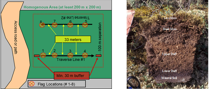
Figure 2. Site set-up of eight plots within each 4 ha site (left) and soil organic horizons sampled (right).
Quality Assessment
Uncertainty was analyzed in the models developed to predict VMC from the probe period, temperature, and soil types. Model standard error, R2, and p values are included in the supplementary document, probe_calibration_supplement.pdf. Predicted volumetric soil moisture measurements that were greater than 100 were set to 100 percent, and less than 0 were set to 0 percent.
Data Acquisition, Materials, and Methods
Data loggers were installed at four 4-ha sites (3 - 10 m x 10 m plots at each site had loggers installed for a total of 12 loggers) in Alaska, U.S. along the Sag River and five 4-ha sites (3 – 10m x 10m plots at each site had loggers installed for a total of 15 loggers) near Red Earth Creek in Alberta, Canada. In Alaska, the sites included tundra vegetation types dominated by sedge, tussocks, and shrubs. In Alberta, the sites were in wooded bog, treed fen, open fen, upland conifer forest, and upland deciduous forest. Probes were installed at depths of 6 to 30 cm below the soil surface. For each probe, the percentage of organic and mineral soil encountered by the probe was measured. The percentages of live moss, dead moss, burned moss, and duff were further measured for the organic soil component.
The Campbell Scientific CR200 data loggers used CS625 water content reflectometers and temperature probe model 109. Moisture and temperature data were recorded every hour.
A model to estimate soil volumetric moisture content (VMC), as described in Section 2, from probe period measurements was developed with regression analysis. This model includes coefficients for five soil types: live spaghnum moss, live feather moss, dead moss, upper duff, and lower duff.
Data Access
These data are available through the Oak Ridge National Laboratory (ORNL) Distributed Active Archive Center (DAAC).
Hourly Soil Moisture Logger Data, Alberta and Alaska, 2017-2021
Contact for Data Center Access Information:
- E-mail: uso@daac.ornl.gov
- Telephone: +1 (865) 241-3952
References
Bourgeau-Chavez, L.L., Garwood, G.C., Riordan, K., Koziol, B.W. and Slawski, J., 2010. Development of calibration algorithms for selected water content reflectometry probes for burned and non-burned organic soils of Alaska. International Journal of Wildland Fire, 19(7), pp.961-975. http://doi.org/10.1071/WF07175
Jandt, R., J. Allen, and E. Horschel. 2005. Forest floor moisture content and fire danger indices in Alaska. USDI BLM/AK/ST-05/009þ9218þ313, Alaska Technical Report 54. (Fairbanks, Alaska)
Nicolsky, D.J., V.E. Romanovsky, A.L. Kholodov, K. Dolgikh, and N. Hasson. 2020. ABoVE: Soil Temperature Profiles, USArray Seismic Stations, AK and Canada, 2016-2019. ORNL DAAC, Oak Ridge, Tennessee, USA. https://doi.org/10.3334/ORNLDAAC/1767
Nicolsky, D.J., V.E. Romanovsky, A.L. Kholodov, K. Dolgikh, and N. Hasson. 2022. ABoVE: Soil Temperature Profiles, USArray Seismic Stations, 2016-2021. ORNL DAAC, Oak Ridge, Tennessee, USA. https://doi.org/10.3334/ORNLDAAC/1680