Get Data
Global Gridded Surfaces of Selected Soil Characteristics (IGBP-DIS)
Summary:
The "Global Gridded Surfaces of Selected Soil Characteristics (IGBP-DIS)" data set contains 7 data surfaces: soil-carbon density, total nitrogen density, field capacity, wilting point, profile available water capacity, thermal capacity, and bulk density.All the surfaces are global, at a resolution of 5x5 arc-minutes, in ASCIIGRID format for ARC INFO. Each file contains a single ASCII array in a geographic (lat/long) projection. The ASCII files consist of header information containing a set of keywords, followed by cell values in row-major order.
These data surfaces were generated by the SoilData System, which was developed by the Global Soil Data Task Group of the International Geosphere-Biosphere Programme (IGBP) Data and Information System (DIS). The SoilData System generates soil information and maps for geographic regions at soil depths and resolutions selected by the user. Derived surfaces of selected soil characteristics are suitable for modeling and inventory purposes. The data surfaces are also distributed as part of the Global Soil Data Products CD-ROM.
The SoilData System uses a statistical bootstrapping approach to link the pedon records in the Global Pedon Database to the FAO/UNESCO Digital Soil Map of the World. It can generate maps and output data sets for a range of original and derived soil parameters, such as carbon and nitrogen density, thermal conductivity, and water-holding capacity, for any part of the world at user-selected depth ranges. The digital output can be at any resolution (in increments of 5').
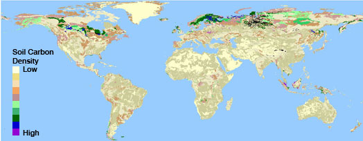
Image of soil-carbon density (kg/m2) at a depth interval of 0-100 cm
See this data set companion file for additional images.
Background:
The Global Soil Data Task was an international collaborative project with the objective of making accurate and appropriate data relating to soil properties accessible to the global change research community. The collaborators are holders of major international pedosphere data sets, such as the U. S. Department of Agriculture, the Food and Agriculture Organization of the United Nations, and the International Soil Reference and Information Centre, as well as national soils institutes, individual soil scientists, and users of soil data. The task was coordinated by the International Geosphere-Biosphere Programme Data and Information System (IGBP-DIS).The task assembled a reliable and accessible data set on pedosphere properties on a global scale. The data are sufficiently detailed to support rigorous analysis, and accessible to and understandable by soil scientists and non-soil scientists alike. The immediate goal was to supply pedosphere information to global change researchers, but the unification and distribution of the existing soils data bases will be of great benefit to all researchers, not only those directly involved in global change studies. The task was enabled by the active participation of the principal international custodians of pedosphere data.
Data Citation:
Cite this data set as follows (citation revised on July 1, 2002):Global Soil Data Task Group. 2000. Global Gridded Surfaces of Selected Soil Characteristics (IGBP-DIS). [Global Gridded Surfaces of Selected Soil Characteristics (International Geosphere-Biosphere Programme - Data and Information System)]. Data set. Available on-line [http://www.daac.ornl.gov] from Oak Ridge National Laboratory Distributed Active Archive Center, Oak Ridge, Tennessee, U.S.A. doi:10.3334/ORNLDAAC/569.
References:
Batjes, N. H. (ed.). 1995. A homogenized soil data file for global environmental research: A subset of FAO, ISRIC and NRCS profiles (Version 1.0). Working Paper and Preprint 95/10b, International Soil Reference and Information Centre, Wageningen, The Netherlands.
Carter, A. J., and R. J. Scholes, 2000. SoilData v2.0: Generating a Global Database of Soil Properties. CSIR Environmentek, Pretoria, South Africa.
Food and Agriculture Organization of the United States (FAO). 1995. The Digital Soil Map of the World, Version 3.5. FAO, Rome, Italy.
Scholes, R. J., D. Skole, and J. S. Ingram (eds.). 1995. A Global Database of Soil Properties: Proposal for Implementation. IGBP-DIS. IGBP-DIS Working Paper # 10a. Report of the Global Soils Task Group, International Geosphere-Biosphere Programme - Data and Information System (IGBP-DIS). University of Paris, France.