Get Data
Revision Date: September 15, 2014
Summary:
This data set describes select global soil parameters from the Harmonized World Soil Database (HWSD) v1.2, including additional calculated parameters such as area weighted soil organic carbon (kg C per m2), as high resolution NetCDF files. These data were regridded and upscaled from the Harmonized World Soil Database v1.2.
The HWSD provides information for addressing emerging problems of land competition for food production, bio-energy demand and threats to biodiversity and can be used as input to model global carbon cycles.
The data are presented as a series of 27 NetCDF v3/v4 (*.nc4) files at 0.05-degree spatial resolution, and one NetCDF file regridded to the Community Land Model (CLM) grid cell resolution (0.9 degree x 1.25 degree) for the nominal year of 2000.
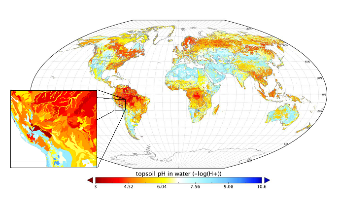
Figure 1. Global map of topsoil pH in water. Inset shows topsoil pH data for southern Peru and Bolivia as an example of the spatial detail available with the 0.05-degree files.
Data and Documentation Access:
Get Data: http://daac.ornl.gov/cgi-bin/dsviewer.pl?ds_id=1247
Data Citation:
Cite this data set as follows:
Wieder, W.R., J. Boehnert, G.B. Bonan, and M. Langseth. 2014. Regridded Harmonized World Soil Database v1.2. Data set. Available on-line [http://daac.ornl.gov] from Oak Ridge National Laboratory Distributed Active Archive Center, Oak Ridge, Tennessee, USA. http://dx.doi.org/10.3334/ORNLDAAC/1247 .
Table of Contents:
- 1 Data Set Overview
- 2 Data Characteristics
- 3 Applications and Derivation
- 4 Quality Assessment
- 5 Acquisition Materials and Methods
- 6 Data Access
- 7 References
1. Data Set Overview:
Investigators: William Wieder (wwieder@ucar.edu), Jennifer Boehnert, Gordon. B. Bonan, and Madison Langseth, National Center for Atmospheric Research.
This data set describes select global soil parameters from the Harmonized World Soil Database v1.2, including additional calculated parameters such as area weighted soil organic carbon (kg C per m2), as high resolution NetCDF files. These data were regridded and upscaled from the Harmonized World Soil Database v1.2.
The HWSD v1.2 (FAO 2012) represents the most exhaustive, comprehensive, and contemporary database of soil characteristics that is available for global analyses and is a powerful resource for evaluating soil biogeochemistry models. Soil characteristics in the HWSD represent data from real soil profiles at various stages of pedogenic development, land use, land use history, and disturbance history. Soil properties in the HWSD are available for surface soil horizons (0 to 30cm) and deeper soil profiles (30 to 100 cm). The HWSD provides information for addressing emerging problems of land competition for food production, bio-energy demand and threats to biodiversity and can be used as input to model global carbon cycles.
The regridded HWSD data are presented as a series of 27 NetCDF v3/v4 (*.nc4) files at 0.05-degree spatial resolution, and one NetCDF file regridded to the Community Land Model (CLM) grid cell resolution (0.9 degree x 1.25 degree) for the nominal year of 2000.
2. Data Characteristics:
Data are presented as a series of 27 NetCDF v3/v4 (*.nc4) files at 0.05-degree spatial resolution, one for each soil parameter (listed in Table 1). Topsoil refers to soil between 0 and 30 cm and subsoil to soil between 30 and 100 cm. Grid cells with no data (fill value or missing values) are represented by “-1”.
Eight of the HWSD soil parameters (listed in Table 2) have been further upscaled to CLM grid cell resolution (0.9-degree x 1.25-degree), in one file “HWSD_SOIL_CLM_RES.nc4”. Soil level 0 here refers to topsoil, and level 1 to subsoil. Grid cells with no data (fill value or missing values) are represented by “9.969E36.”
A companion file HWSD1.2_documentation.pdf contains a full description of the data compilation and harmonization procedure for the original HWSD v1.2 data.
Data File Information
Table 1. Data File Information
| File Name | Description | Units | Notes |
|---|---|---|---|
| AWC_CLASS | Available water storage capacity | Coded values 1 through 7 | 1 = 150 mm water per m of the soil unit, 2 = 125 mm, 3 = 100 mm, 4 = 75 mm, 5 = 50 mm, 6 = 15 mm, 7 = 0 mm. |
| ISSOIL | Soil or non-soil units | 0 or 1 | ISSOIL indicates whether the soil mapping unit is a soil (1) or non-soil (0) |
| MU_GLOBAL | HWSD global mapping unit identifier | numerical ID | MU_GLOBAL provides a link from the grid cell to the other attributes.The HWSD v1.2 attribute lookup table is available from the HWSD project (FAO 2012) |
| REF_DEPTH | Reference soil depth | cm | Reference soil depth of all soil units are set at 100 cm, except for Rendzinas and Rankers of FAO-74 and Leptosols of FAO-90, where the reference soil depth is set at 30 cm, and for Lithosols of FAO-74 and Lithic Leptosols of FAO-90, where it is set at 10 cm. |
| ROOTS | Depth of obstacles to roots | Coded values 0 through 6 | 0 = no information, 1 = no obstacles to roots between 0 and 80 cm depth, 2 = obstacles to roots between 60 and 80 cm depth, 3 = obstacles between 40 and 60 cm, 4 = 20 and 40 cm, 5 = 0 and 80 cm, 6 = 0 and 20 cm. |
| T_BULK_DEN | Topsoil bulk density | kg dm-3 | |
| S_BULK_DEN | Subsoil bulk density | kg dm-3 | |
| T_REF_BULK | topsoil bulk density | kg dm-3 | Reference bulk density values are calculated from equations developed by Saxton et al. (1986) that relate to the texture of the soil only. These estimates, although generally reliable, overestimate the bulk density in soils that have a high porosity (Andosols) or that are high in organic matter content (Histosols). The calculation procedures for reference bulk density can be found in Saxton et al (1986) |
| S_REF_BULK | Subsoil reference bulk density | kg dm-3 | |
| T_CEC_CLAY | Cation exchange capacity of the clay fraction in the topsoil | cmol per kg | |
| S_CEC_CLAY | Cation exchange capacity of the clay fraction in the subsoil | cmol per kg | |
| T_CLAY | Topsoil clay fraction | % weight | |
| S_CLAY | Subsoil clay fraction | % weight | |
| T_GRAVEL | Topsoil gravel content | % volume | |
| S_GRAVEL | Subsoil gravel content | % volume | |
| T_SAND | Topsoil sand fraction | % weight | |
| S_SAND | Subsoil sand fraction | % weight | |
| T_SILT | Topsoil silt fraction | % weight | |
| S_SILT | Subsoil silt fraction | % weight | |
| T_PH_H20 | Topsoil pH (in H2O) | -log(H+) | |
| S_PH_H20 | Subsoil pH (in water) | -log(H+) | |
| T_C | Topsoil carbon content | kg C m-2 | Topsoil and subsoil carbon content (T_C and S_C) are based on the carbon content of the dominant soil type in each regridded cell rather than a weighted average. |
| S_C | Dominant soil type subsoil carbon content | kg C m-2 | |
| T_OC | Topsoil organic carbon | % weight | |
| S_OC | Subsoil organic carbon | % weight | |
| AWT_S_SOC | Area weighted subsoil carbon content | kg C m-2 | AWT_S_SOC = (sum(SEQ(SHARE * S_OC)) * 7 * S_BULK_DENSITY) |
| AWT_T_SOC | Area weighted topsoil carbon content | kg C m-2 | AWT_T_SOC = (sum(SEQ(SHARE * T_OC)) * 3 * T_BULK_DENSITY) |
Table 2. HWSD_SOIL_CLM_RES file contents.
| Variable | Description | Units |
|---|---|---|
| AWT_SOC | Area-weighted soil organic carbon content | kg C m-2 |
| BULK_DEN | Soil bulk density | kg dm-3 |
| DOM_MU | Dominant mapping unit ID from HWSD (MU_GLOBAL above) | |
| DOM_SOC | Dominant soil mapping unit soil organic carbon content (T_C & S_C above) | kg C m-2 |
| PCT_CLAY | Soil clay fraction by percent weight | % |
| PCT_SAND | Soil sand fraction by percent weight | % |
| PH | Soil pH in water for the dominant mapping unit | -log(H+) |
| REF_BULK | Soil reference bulk density | kg dm-3 |
Spatial Coverage
Global
Spatial Resolution
Most data files contain grid cells at 3 minute x 3 minute (0.05 degrees or approximately 8-km). File “HWSD_SOIL_CLM_RES.nc4” provides eight soil characteristics at 0.9-degree x 1.25-degree resolution.
Site boundaries: (All latitude and longitude given in degrees and fractions)
| Westernmost Longitude | Easternmost Longitude | Northernmost Latitude | Southernmost Latitude |
|---|---|---|---|
| -180 | 180 | 90 | -90 |
Temporal Coverage
One time.
Time period
The data set has no explicit temporal component. Data are nominally for the year 2000/01/01 to 2000/12/31.
3. Data Application and Derivation:
The HWSD provides information for addressing emerging problems of land competition for food production, bio-energy demand and threats to biodiversity. These data can be used as input to terrestrial biosphere models, such as the Community Land Model (CLM) (see Wieder et al. 2014).
4. Quality Assessment:
All fields in the Harmonized World Soil Database were checked for minimum, maximum, average, and standard deviation values in order to find outliers, data entry errors etc. Few errors were found, and these were corrected from neighboring units consisting of the same soil type. Few missing data values exist in the source databases. Many missing values were replaced with data extracted from the most appropriate neighboring units having the same soil type.
5. Data Acquisition Materials and Methods
The investigators regridded the HWSD from its native resolution to 0.05 degree resolution grid cells and upscaled these to the CLM grid, 0.9 degree x 1.25 degree. Using Environmental Systems Research Institute ArcGIS 10.0, they performed zonal statistics on the HWSD to obtain the most common HWSD soil mapping unit identifier (MU_GLOBAL) for each 0.05-degree grid cell. They then calculated the SOC by multiplying the soil organic C (%) by bulk density (kilogram per cubic meter) and soil depth for each soil mapping unit. They regridded the SOC pools from the 30 arc sec HWSD grid to the CLM grid cell using an area-weighted, mass-conserving algorithm. This area-weighting approach better represents the spatial heterogeneity of SOC pools within the larger CLM grid cell. More details can be found in Wieder et al. (2014).
A full description of the data compilation and harmonization procedure for the original HWSD v1.2 data are provided in the companion file: HWSD1.2_documentation.pdf.
6. Data Access:
This data is available through the Oak Ridge National Laboratory (ORNL) Distributed Active Archive Center (DAAC).
Data Archive Center:
Contact for Data Center Access Information:
E-mail: uso@daac.ornl.gov
Telephone: +1 (865) 241-3952
7. References:
FAO 2012. Harmonized World Soil Database (version 1.2). Food Agriculture Organization, Rome, Italy and IIASA, Laxenburg, Austria (http://webarchive.iiasa.ac.at/Research/LUC/External-World-soil-database/HTML/)
Wieder, W.R., J. Boehnert, and G.B. Bonan. (2014). Evaluating soil biogeochemistry parameterizations in Earth system models with observations, Global Biogeochem. Cycles, 28, 211–222, doi:10.1002/2013GB004665.
Saxton, K.E., W.J. Rawls, J.S. Romberger, and R.I. Papendick. 1986. Estimating Generalized Soil-water Characteristics from Texture. Soil Sci. Soc. Am. J 50, 1031-1036.