Documentation Revision Date: 2022-01-10
Dataset Version: 1
Summary
There are 197 data files in netCDF (*.nc) format included in this dataset.
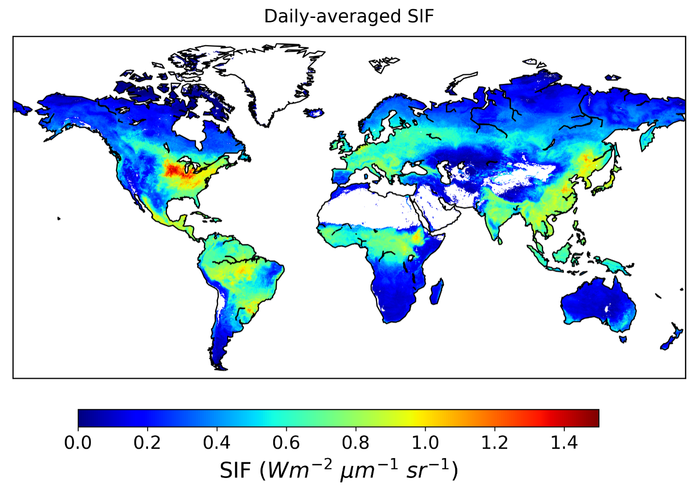
Figure 1. Daily-corrected SIF at 740 nm for August 2015. The highest SIF values during this time period were observed in agricultural sectors in the Northern Hemisphere.
Citation
Wen, J., P. Koehler, G. Duveiller, N.C. Parazoo, T. Magney, G. Hooker, L. Yu, C.Y. Chang, and Y. Sun. 2021. Global High-Resolution Estimates of SIF from Fused SCIAMACHY and GOME-2, 2002-2018. ORNL DAAC, Oak Ridge, Tennessee, USA. https://doi.org/10.3334/ORNLDAAC/1864
Table of Contents
- Dataset Overview
- Data Characteristics
- Application and Derivation
- Quality Assessment
- Data Acquisition, Materials, and Methods
- Data Access
- References
Dataset Overview
This dataset provides global solar-induced chlorophyll fluorescence (SIF) estimates at a 0.05-degree resolution (approximately 5 km at the equator) for each month from August 2002 through December 2018. SIF data (740 nm) was retrieved from the SCanning Imaging Absorption spectroMeter for Atmospheric CHartographY (SCIAMACHY) and Global Ozone Monitoring Experiment 2 (GOME-2) instruments onboard the MetOp-A satellite and was downscaled to 0.05 degree using Random Forest algorithm and harmonized with cumulative distribution function (CDF) matching technique. The uncertainty of the SIF estimates was also quantified and is provided. Validation of the harmonized product showed that it retained high spatial and temporal consistency with the original SCIAMACHY and GOME-2 SIF retrievals and had good correlations with independent airborne and ground-based SIF measurements. The dataset will inform on the synergy between satellite SIF and photosynthesis and research on drought, yield estimation, and land degradation evaluation.
Project: Solar Induced Fluorescence Earth Science Data Record
This project is developing a global, observation-based Earth System Data Record (ESDR) for quantifying global vegetation solar induced fluorescence (SIF) and photosynthesis gross primary productivity (GPP) from 1996-2020. It was funded under the 2017 Making Earth System Data Records for Use in Research Environments (MEaSUREs) call (17-MEASURES-0032).
Related Publication
Wen, J., P. Köhler, G. Duveiller, N. C. Parazoo, T. S. Magney, G. Hooker, L. Yu, C. Y. Chang, and Y. Sun. 2020. A framework for harmonizing multiple satellite instruments to generate a long-term global high spatial-resolution solar-induced chlorophyll fluorescence (SIF). Remote Sensing of Environment 239:111644. https://doi.org/10.1016/j.rse.2020.111644
Related Datasets
Additional SIF-ESDR datasets are available on the ORNL DAAC SIF-ESDR project page.
Acknowledgments
This work was supported by the NASA Making Earth System Data Records for Use in Research Environments (MEaSUREs) program (grant NNX15AH95G, 17-MEASURES-0032)
J. Wen and Y. Sun are funded by the USAID Feed the Future program 7200AA18CA00014. Y. Sun, N.C. Parazoo, and T. S. Magney acknowledge the support from Earth Sciences Division MEaSUREs program. P. Köhler is funded by the Earth Science U.S. Participating Investigator (Grant Number: NNX15AH95G). G. Duveiller is funded at the European Commission Joint Research Centre by the Copernicus-2 administrative agreement (nr. 5054) supported by DG-GROW. T. S. Magney is supported by the OCO-2 Science Team at the Jet Propulsion Laboratory, California Institute of Technology. G. Hooker is funded with National Science Foundation DMS-1712554 and TRIPODS 1740882. L. Yu is funded by the 2018 China Scholarship Council (CSC)-IBM Future Data Scientist Scholarship Program. C. Y. Chang is supported by USDA-NIFA postdoctoral fellowship (Grant Number: 2018-67012-27985).
Data Characteristics
Spatial Coverage: Global
Spatial Resolution: 0.05 degree (approximately 5 km at the equator)
Temporal Coverage: 2002-08-01 to 2018-12-31
Temporal Resolution: Monthly
Study Area: Latitude and longitude are given in decimal degrees.
| Site | Northernmost Latitude | Southernmost Latitude | Easternmost Longitude | Westernmost Longitude |
|---|---|---|---|---|
| Global | 90 | -90 | 180 | -180 |
Data File Information
There are 197 files in netCDF (*.nc) format. The file naming convention is SIF005_YYYYMM.nc, where YYYYMM represents the year and month of data collection.
Table 1. File names and descriptions.
| File Names | Description |
|---|---|
| SIF005_YYYYMM.nc | Each file provides daily corrected SIF at 740nm and its associated uncertainty. |
Data File Details
- Missing values are represented by -999.0.
- Coordinate reference system: "WGS84 - World Geodetic System 1984" (EPSG:4326)
- A mask was applied to non-vegetated regions (i.e., Water Bodies, Barren, and Permanent Snow and Ice according to MCD12C1.006 IGBP classification).
Table 2. Variable names and descriptions.
| Variable Name | Units | Description |
|---|---|---|
| crs | Coordinate Reference System information | |
| EVI_Quality | MODIS enhanced vegetation index quality flag; detailed flag information can be found in MOD13C2.006 User Manual Table 5 (see Section 5) | |
| lat | degree north | Latitude at the center of the pixel |
| lon | degree east | Longitude at the center of the pixel |
| SIF_740_daily_corr | mW/m2/nm/sr | Daily-corrected SIF at 740nm at a 0.05-degree resolution |
| SIF_740_daily_corr_SD | mW/m2/nm/sr | Uncertainty of daily-corrected SIF at 740nm |
Application and Derivation
This long SIF record will greatly enhance the synergy between satellite SIF and photosynthesis. This product has also been used in applications such as drought monitoring, yield estimation, land degradation evaluation, etc.
Quality Assessment
The infinitesimal jackknife method was used to estimate standard errors of random forest predictions. The estimation was accomplished by evaluating the covariance between certain predictions from each individual tree and the number of times each training sample appeared in a bootstrap sample for that tree (Wager et al., 2014; Ghosal and Hooker, 2018). Smaller covariance means the prediction was less affected by whether a certain training sample is in the bootstrapped sample or not, therefore, had less variance and thus less uncertainty.
Data Acquisition, Materials, and Methods
This dataset was produced based on the framework described in Wen et al. (2020) by fusing SIF retrievals from SCanning Imaging Absorption spectroMeter for Atmospheric CHartographY (SCIAMACHY) and Global Ozone Monitoring Experiment 2 (GOME-2) onboard MetOp-A developed at German Research Center for Geosciences. First, the original Level 3 SIF retrievals of SCIAMACHY and GOME-2 (Köhler et al., 2015) were downscaled from their native resolutions to 0.05° using machine learning (ML) algorithms imposed by regionalization constraints to account for the varying relationships between predictors and SIF in space and time. Then the cumulative distribution function matching technique was applied to correct the offset between SIF retrieved from GOME2_005 and SIF retrieved from SCIAMACHY as inherited from the original instrumental discrepancies to generate a harmonized SIF time series. See Wen et al. (2020) for detailed methods.
Note that one main difference between the method used to create this dataset and the method described in Wen et al. (2020) is the predictors used. Wen et al. (2020) used MODIS 7-band BRDF-corrected reflectance (MCD43C4 v006) as predictors, which introduced missing values in some vegetated regions owing to missing values in the original predictors (i.e., MCD43C4 v006). To overcome this issue, the current dataset was generated using the same algorithm and model settings as the unpublished dataset, except that predictors were changed to use MODIS EVI from MOD13C2.006 (Didan, 2015), and PAR, 2 m air temperature, and VPD from MERRA-2 (v5.12.4; GMAO, 2015). The current dataset has been validated with the same metrics as in Wen et al. (2020), and no significant difference was discerned (CFIS R2 = 0.73; tower SIF R2 = 0.92; tower SIFyield R2 = 0.95). Nevertheless, minor differences at fine spatial scale are expected between the two approaches owing to different predictors.
With EVI as one important input of the model, a quality flag layer was added, and it is recommended that users check this flag prior to analysis. This quality flag layer is collected from the MODIS EVI QC layer and detailed bit information can be found in MOD13C2.006 User Manual Table 5 (Didan, 2015; available at https://lpdaac.usgs.gov/documents/103/MOD13_User_Guide_V6.pdf). Users must extract the value of the desired bit(s) to match with the information in the table (see https://modis-images.gsfc.nasa.gov/tools_bit_interpretation.html).
Data Access
These data are available through the Oak Ridge National Laboratory (ORNL) Distributed Active Archive Center (DAAC).
Global High-Resolution Estimates of SIF from Fused SCIAMACHY and GOME-2, 2002-2018
Contact for Data Center Access Information:
- E-mail: uso@daac.ornl.gov
- Telephone: +1 (865) 241-3952
References
Didan, K. 2015. MOD13C2 MODIS/Terra Vegetation Indices Monthly L3 Global 0.05Deg CMG V006. NASA EOSDIS Land Processes DAAC. https://doi.org/10.5067/MODIS/MOD13C2.006
Ghosal, I., and G. Hooker. 2020. Boosting Random Forests to Reduce Bias; One-Step Boosted Forest and Its Variance Estimate. Journal of Computational and Graphical Statistics:1–10. https://doi.org/10.1080/10618600.2020.1820345
GMAO(Global Modeling and Assimilation Office (GMAO) (2015), MERRA-2 tavgM_2d_aer_Nx: 2d, Monthly mean, Time-averaged, Single-Level, Assimilation, Aerosol Diagnostics V5.12.4, Greenbelt, MD, USA, Goddard Earth Sciences Data and Information Services Center (GES DISC). https://doi.org/10.5067/FH9A0MLJPC7N
Köhler, P., L. Guanter, and J. Joiner. 2015. A linear method for the retrieval of sun-induced chlorophyll fluorescence from GOME-2 and SCIAMACHY data. Atmospheric Measurement Techniques 8:2589–2608. https://doi.org/10.5194/amt-8-2589-2015
Wager, S., T. Hastie, and B. Efron. 2014. Confidence intervals for random forests: The jackknife and the infinitesimal jackknife. The Journal of Machine Learning Research 15(1):1625-1651. (http://jmlr.org/papers/v15/wager14a.html)
Wen, J., P. Köhler, G. Duveiller, N. C. Parazoo, T. S. Magney, G. Hooker, L. Yu, C. Y. Chang, and Y. Sun. 2020. A framework for harmonizing multiple satellite instruments to generate a long-term global high spatial-resolution solar-induced chlorophyll fluorescence (SIF). Remote Sensing of Environment 239:111644. https://doi.org/10.1016/j.rse.2020.111644