Documentation Revision Date: 2022-01-10
Dataset Version: 2
Summary
There are 138 data files in netCDF (*.nc) format.

Figure 1. Predicted spatially contiguous SIF in the first half of August 2015. The highest SIF values during this time period were observed in agricultural sectors in the Northern Hemisphere. Source: Data file sif_ann_201508a.nc
Citation
Yu, L., J. Wen, C.Y. Chang, C. Frankenberg, and Y. Sun. 2021. High Resolution Global Contiguous SIF Estimates from OCO-2 SIF and MODIS, Version 2. ORNL DAAC, Oak Ridge, Tennessee, USA. https://doi.org/10.3334/ORNLDAAC/1863
Table of Contents
- Dataset Overview
- Data Characteristics
- Application and Derivation
- Quality Assessment
- Data Acquisition, Materials, and Methods
- Data Access
- References
- Dataset Revisions
Dataset Overview
This dataset provides spatially-contiguous global mean daily solar-induced chlorophyll fluorescence (SIF) estimates at 0.05 degree (approximately 5 km at the equator) spatial and 16-day temporal resolution from September 2014 through July 2020. This product was derived from Orbiting Carbon Observatory-2 (OCO-2) SIF observations and produced by training an artificial neural network (ANN) on the native OCO-2 SIF observations and MODIS BRDF-corrected seven-band surface reflectance along OCO-2's orbits. The trained ANN model was then applied to predict mean daily SIF (mW/m2/nm/sr) in OCO-2's gap regions based on MODIS reflectance and landcover. This framework was stratified by biomes and 16-day time steps. This dataset's high resolution and global contiguous coverage will greatly enhance the synergy between satellite SIF and photosynthesis measured on the ground at consistent spatial scales. Potential applications of this dataset include advancing dynamic drought monitoring and mitigation, informing agricultural planning and yield estimation, and providing a benchmark for upcoming satellite missions with SIF capabilities at higher spatial resolutions.
Project: Solar Induced Fluorescence Earth Science Data Record
This project is developing a global, observation-based Earth System Data Record (ESDR) for quantifying global vegetation solar induced fluorescence (SIF) and photosynthesis gross primary productivity (GPP) from 1996-2020. It was funded under the 2017 Making Earth System Data Records for Use in Research Environments (MEaSUREs) call (17-MEASURES-0032).
Related Publication
Yu, L., J. Wen, C.Y. Chang, C. Frankenberg, and Y. Sun. 2019a. High-Resolution Global Contiguous SIF of OCO-2. Geophysical Research Letters 46:1449–1458. https://doi.org/10.1029/2018GL081109
Related Dataset
Yu, L., J. Wen, C.Y. Chang, C. Frankenberg, and Y. Sun. 2019b. High Resolution Global Contiguous SIF Estimates Derived from OCO-2 SIF and MODIS. ORNL DAAC, Oak Ridge, Tennessee, USA. https://doi.org/10.3334/ORNLDAAC/1696
- Version 1 of the current dataset. Now superseded and available only upon request.
Acknowledgments
This work was supported by NASA's OCO-2 science team (grant 80NSSC18K0895), Carbon Cycle Science (grant NNX17AE14G), the Earth Science Division MEaSUREs program (grant 17-MEASURES-0032). L.Y. acknowledges the 2018 CSC-IBM Future Data Scientist Scholarship Program, C.Y.C. acknowledges the USDA-NIFA postdoctoral fellowship 2018-67012-27985, and C.F. acknowledges the Jet Propulsion Laboratory's support for CFIS.
Data Characteristics
Spatial Coverage: Global
Spatial Resolution: 0.05 degree (approximately 5 km at the equator)
Temporal Coverage: 2014-09-01 to 2020-07-31
Temporal Resolution: 16-day
Study Area: Latitude and longitude are given in decimal degrees.
| Site | Northernmost Latitude | Southernmost Latitude | Easternmost Longitude | Westernmost Longitude |
|---|---|---|---|---|
| Global | 180 | -180 | 90 | -90 |
Data File Information
There are 138 data files in netCDF (*.nc) format. Generally, two “16-day” files per month. There are four files in the time series (201504b, 201708a, 201708b, 201709a) that are not available because no OCO-2 SIF data were collected during these periods owing to instrument failure.
The file naming convention for sif_ann_YYYYMMx.nc, where YYYYMM represents the year and month, and x is either "a" or "b".
File names ending in "a" represent the first half of each month and the files ending in "b" represent the second half of the month.
Note that 'ann' indicates that the data were modeled by an artificial neural network.
Table 1. File names and descriptions.
| File Names | Description |
|---|---|
| sif_ann_YYYYMMx.nc |
Mean daily SIF model by ANN for each 0.05-degree grid cell over the 16-day time period. |
Data File Details
There are no missing values. The projection used is "WGS84" (EPSG:4326).
Table 2. Variable names and descriptions.
| Variable Name | Units | Description |
|---|---|---|
| crs | Coordinate Reference System information | |
| lat | degree north | Latitude at center of cell |
| lon | degree east | Longitude at center of cell |
| sif_ann | mW/m2/nm/sr | Mean daily SIF model by ANN for each 0.05 degree grid cell over the 16-day time period |
Application and Derivation
Potential applications of this dataset include advancing dynamic drought monitoring and mitigation, informing agricultural planning and yield estimation, and providing a benchmark for upcoming satellite missions with SIF capabilities at higher spatial resolutions.
Quality Assessment
The prediction framework was validated using three approaches. First, five-fold cross-validation was used to compare predicted SIF along OCO-2 orbits against observations that were not used in training, that is, 20% of samples selected for cross-validation for each sub-biome and time step during the entire period. Second, predicted SIF was compared with independent airborne measurements from the Chlorophyll Fluorescence Imaging Spectrometer (CFIS) airborne measurements, which were specifically designed by the OCO-2 team to validate OCO-2 SIF retrieval (Frankenberg et al., 2018). Third, 0.05° predictions were reaggregated to 1° to examine its residuals in relation to the original OCO-2 SIF gridded at 1°. For details, see Yu et al. (2019a).
In principle, SIF should always be positive. However, some negative values appear in the data because of (1) retrieval noise in the original OCO-2 SIF; (2) modelling uncertainty of the machine-learning model which was utilized to generate high-resolution SIF from the original OCO-2 SIF. Slightly negative values (e.g., from -1 to 0) are expected, especially in low productive regions/time periods. In this case, the negative values should be retained, otherwise it may lead to a positive bias in statistics. If the negative values are very significant (e.g., less than -1), which is highly likely due to imperfect model prediction, smoothing (e.g., replacing with average SIF calculated from nearby pixels or time steps) is suggested.
Data Acquisition, Materials, and Methods
The overall strategy of the prediction framework was to (1) use the artificial neural network (ANN) algorithm to train the native OCO-2 SIF (v10r, https://disc.gsfc.nasa.gov/datasets/OCO2_L2_Lite_SIF_10r/summary?keywords=OCO-2) along orbits against MODIS bidirectional reflectance distribution function (BRDF)-corrected seven-band surface reflectance (using MCD43A4 and MCD43C4 V006 products; Schaaf and Wang, 2015a and 2015b, respectively)) that were co-located with OCO-2 footprints during its overpass and (2) apply the trained ANN models to predict SIF in OCO-2’s orbital gaps using spatially contiguous MODIS datasets as predictors.
Distinct ANN models were derived for each IGBP (International Geosphere-Biosphere Programme) biome type at each time step based on MODIS land cover products (MCD12Q1 for training and MCD12C1 for prediction; Friedl and Sulla-Menashe, 2015a and 2015b, respectively). More information can be found in Yu et al. (2019a). Detailed descriptions of the OCO-2 SIF retrieval algorithms, bias correction procedures, daily mean conversion, and wavelength scaling can be found in Sun et al. (2018).
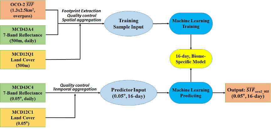
Figure 2. Workflow of the developed prediction framework for OCO-2 SIF gap filling.
Data Access
These data are available through the Oak Ridge National Laboratory (ORNL) Distributed Active Archive Center (DAAC).
High Resolution Global Contiguous SIF Estimates from OCO-2 SIF and MODIS, Version 2
Contact for Data Center Access Information:
- E-mail: uso@daac.ornl.gov
- Telephone: +1 (865) 241-3952
References
Frankenberg, C., P. Köhler, T.S. Magney, S. Geier, P. Lawson, M. Schwochert, J. McDuffie, D.T. Drewry, R. Pavlick, and A. Kuhnert. 2018. The Chlorophyll Fluorescence Imaging Spectrometer (CFIS), mapping far red fluorescence from aircraft. Remote Sensing of Environment 217:523–536. https://doi.org/10.1016/j.rse.2018.08.032
Friedl, M., D. Sulla-Menashe. 2015a. MCD12C1 MODIS/Terra+Aqua Land Cover Type Yearly L3 Global 0.05Deg CMG V006. Distributed by NASA EOSDIS Land Processes DAAC. https://doi.org/10.5067/MODIS/MCD12C1.006
Friedl, M., D. Sulla-Menashe. 2019b. MCD12Q1 MODIS/Terra+Aqua Land Cover Type Yearly L3 Global 500m SIN Grid V006. Distributed by NASA EOSDIS Land Processes DAAC. https://doi.org/10.5067/MODIS/MCD12Q1.006
Schaaf, C., Z. Wang. 2015a. MCD43A4 MODIS/Terra+Aqua BRDF/Albedo Nadir BRDF Adjusted Ref Daily L3 Global - 500m V006. Distributed by NASA EOSDIS Land Processes DAAC. https://doi.org/10.5067/MODIS/MCD43A4.006
Schaaf, C., Z. Wang. 2015b. MCD43C4 MODIS/Terra+Aqua BRDF/Albedo Nadir BRDF-Adjusted Ref Daily L3 Global 0.05Deg CMG V006. Distributed by NASA EOSDIS Land Processes DAAC. https://doi.org/10.5067/MODIS/MCD43C4.006
Sun, Y., C. Frankenberg, M. Jung, J. Joiner, L. Guanter, P. Köhler, and T. Magney. 2018. Overview of Solar-Induced chlorophyll Fluorescence (SIF) from the Orbiting Carbon Observatory-2: Retrieval, cross-mission comparison, and global monitoring for GPP. Remote Sensing of Environment 209:808–823. https://doi.org/10.1016/j.rse.2018.02.016
Yu, L., J. Wen, C.Y. Chang, C. Frankenberg, and Y. Sun. 2019a. High-Resolution Global Contiguous SIF of OCO-2. Geophysical Research Letters 46:1449–1458. https://doi.org/10.1029/2018GL081109
Yu, L., J. Wen, C.Y. Chang, C. Frankenberg, and Y. Sun. 2019b. High Resolution Global Contiguous SIF Estimates Derived from OCO-2 SIF and MODIS. ORNL DAAC, Oak Ridge, Tennessee, USA. https://doi.org/10.3334/ORNLDAAC/1696
Dataset Revisions
| Version | Release Date | Revision Notes | DOI |
|---|---|---|---|
| 1 | 2019-09-09 | Initial release, produced with OCO-2 SIF retrieval version 8. Superseded by Version 2 and available only upon request. Included data from September 2014 through January 2019 | https://doi.org/10.3334/ORNLDAAC/1696 |
| 2 |
2021-08-13 |
This version extends the data period through July 2020. This is an updated version, produced with OCO-2 SIF retrieval version 10. Processing and modeling of Versions 1 and 2 were the same. | https://doi.org/10.3334/ORNLDAAC/1863 |