Documentation Revision Date: 2023-09-04
Dataset Version: 1
Summary
There are four files in this dataset: one file in comma-separated values (CSV) format holding calculated reflectance values and three compressed zip archives holding raw sensor measurements in CSV format.
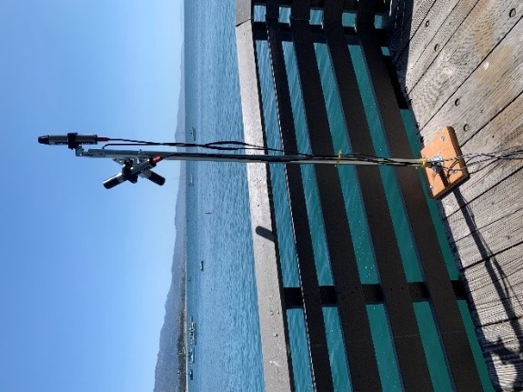
Figure 1. Ramses TriOS radiometer deployed on Stearns Wharf behind the Santa Barbara Museum of Natural History Sea Center. Three sensors are used to collect irradiance, downwelling radiance, and upwelling radiance measurements.
Citation
Ade, C., E.L. Hestir, D.M. Avouris, J. Burmistrova, C. Nickles, A.M. Lopez, B. Lopez Barreto, J. Vellanoweth, R. Smalldon, and C.M. Lee. 2023. SHIFT: Ramses Trios Radiometer Above Water Measurements, Santa Barbara Sea, CA. ORNL DAAC, Oak Ridge, Tennessee, USA. https://doi.org/10.3334/ORNLDAAC/2234
Table of Contents
- Dataset Overview
- Data Characteristics
- Application and Derivation
- Quality Assessment
- Data Acquisition, Materials, and Methods
- Data Access
- References
Dataset Overview
This dataset provides calculated remote sensing reflectance (Rrs) from measurements collected with a Ramses TriOS radiometer deployed on the Santa Barbara Museum of Natural History Sea Center at Stearns Wharf, Santa Barbara, California, U.S. All measurements were taken over a fixed position at (34.41037665, -119.68557147). Three sensors are used to collect solar downwelling irradiance (Ed), sky radiance (Ls) and water-leaving radiance (Lw). These data have been processed to Rrs at 10 second intervals and are either concurrent or taken within 2.5 hours of SHIFT campaign flights. The data collected by the three Ramses TriOS sensors for eight days during the period 2022-04-05 to 2022-05-29 are also included. The data were translated from the proprietary format output by the Ramses TriOS instrument and saved in comma-separated values (CSV) format.
Project: Surface Biology and Geology High-Frequency Time Series (SHIFT)
The Surface Biology and Geology (SBG) High Frequency Time Series (SHIFT) was an airborne and field campaign during February to May, 2022, with a follow up activity for one week in September, in support of NASA's SBG mission. Its study area included a 640-square-mile (1,656-square-kilometer) area in Santa Barbara County and the coastal Pacific waters. The primary goal of the SHIFT campaign was to collect a repeated dense time series of airborne Visible to ShortWave Infrared (VSWIR) airborne imaging spectroscopy data with coincident field measurements in both inland terrestrial and coastal aquatic areas, supported in part by a broad team of research collaborators at academic institutions. The SHIFT campaign leveraged NASA's Airborne Visible-Infrared Imaging Spectrometer-Next Generation (AVIRIS-NG) facility instrument to collect approximately weekly VSWIR imagery across the study area. The SHIFT campaign 1) enables the NASA SBG team to conduct traceability analyses related to the science value of VSWIR revisit without relying on multispectral proxies, 2) enables testing algorithms for consistent performance over seasonal time scales and end-to-end workflows including community distribution, and 3) provides early adoption test cases to SHIFT application users and incubate relationships with basic and applied science partners at the University of California Santa Barbara Sedgwick Reserve and The Nature Conservancy's Jack and Laura Dangermond Preserve.
Acknowledgement
SHIFT is jointly led by NASA’s Jet Propulsion Laboratory, The Nature Conservancy, and the University of California, Santa Barbara (UCSB).
Data Characteristics
Spatial Coverage: Santa Barbara Museum of Natural History Sea Center at Stearns Wharf, Santa Barbara, California, U.S.
Spatial Resolution: Single location
Temporal Coverage: Measurements were made on the following eight days: 2022-04-05, 2022-04-12, 2022-04-20, 2022-04-29, 2022-05-03, 2022-05-11, 2022-05-17, 2022-05-29. Future updates will include data from 2022-09-15.
Temporal Resolution: Variable, but all dates are concurrent with SHIFT overpasses.
Study Area: Latitude and longitude are provided in decimal degrees.
| Site (Region) | Westernmost Longitude | Easternmost Longitude | Northernmost Latitude | Southernmost Latitude |
| Santa Barbara Museum of Natural History Sea Center at Stearns Wharf, Santa Barbara, California, U.S. | -119.686 | -119.6818 | 34.4106 | 34.41038 |
There are four files in this dataset: one file in comma-separated values (.csv) format holding calculated reflectance values and three compressed zip archives (.zip) holding raw sensor measurements in CSV format.
Ramses_SHIFT_Rrs.csv: holds with calculated remote sensing reflectances (Rrs) in 10 second intervals. Each row is an individual spectrum.
The three zip archives hold raw measurement data collected by the three Ramses TriOS sensors on eight dates.
- Irrad_TriOS_SHIFTv2.zip: measurments of solar downwelling irradiance (Ed)
- Sky_TriOS_SHIFTv2.zip: measurments of sky radiance (Ls)
- Water_TriOS_SHIFTv2.zip: measurments of water-leaving radiance (Lw)
Each zip archive has eight files that hold data translated from the proprietary format output by the Ramses TriOS instrument and saved in comma-separated values (CSV) format. Within each zip archive, the file naming convention is mmddyy_variable_TriOS_SHIFTv2.csv, where
- mmddyy = date of meaurement in month, day, and two-digit year: 040522, 041222, 042022, 042922, 050322, 051122, 051722, or 052922
- variable = measured variable: "Irrad" = solar downwelling irradiance (Ed), "Sky" = sky radiance (Ls), or "Water" = water-leaving radiance (Lw).
Example file name: 052922_Water_TriOS_SHIFTv2.csv (in Water_TriOS_SHIFTv2.zip).
Variables in the data files
Table 1. Variables in the file Ramses_SHIFT_Rrs.csv. Several fields were included to maintain compatibility across several SHIFT spectral datasets. Each row represents a single remote sensing reflectance spectrum (unitless). Measurements from each date were taken in 10 second intervals.
| Column Number | Column Name | Units/format | Description |
|---|---|---|---|
| 1 | unique_id | - | The unique id for that individual spectrum. The id is the date_utc value and the sample number on that given date separated by an underscore |
| 2 | date_utc | YYYY-MM-DD | Date of collection |
| 3 | time_local | hh:mm:ss | Time of collection in US/Pacific timezone |
| 4 | datetime_utc | YYYY-MM-DD hh:mm:ss | Date time of collection in UTC |
| 5 | instrument | - | The instrument used for in-situ field collection. All rows should read “ramses_trios” |
| 6 | latitude | degree north | Latitude coordinate for location in decimal degrees |
| 7 | longitude | degrees east | Longitude coordinate for location in decimal degrees |
| 8 | target_type | - | Type of surface measured. All should read “water” |
| 9 | measurement_type | - | Denotes the spectral type. All should read “remote_sensing_reflectance” |
| 10 | site_id | - | Site description as text. All should read “santa_barbara_pier” |
| 11 | light_source | - | The light source for spectral measurements. All should read “sun” |
| 12 | lab | 0/1 (no/yes) | Indicates if the measurement was taken in a lab or not. All should read “0” |
| 13- 203 | 320 – 951 | sr-1 | Remote sensing reflectance values (Rrs); the numbers in the column names refer to the wavelengths in nanometers in 3-nm intervals |
Sensor measurements: The 24 CSV files in the zip archives have a wavelength column folllowed by columns holding the measured solar downwelling irradiance (Ed), sky radiance (Ls), or water-leaving radiance (Lw). The name of each column holding measured values is the date and time of collection formatted as YYYY-MM-DD_hh-mm-ss.
The units for measured values are:
- solar (downwelling) irradiance (Ed): W m-2
- sky radiance (Ls): W m-2 sr-1
- water-leaving radiance (Lw): W m-2 sr-1
Table 2. Example data from the file 052922_Water_TriOS_SHIFTv2.csv in Water_TriOS_SHIFTv2.zip.
| Wavelength | 2022-05-29_11-00-10 | 2022-05-29_11-00-20 | 2022-05-29_11-00-30 |
| 310 | 0 | 0 | 0 |
| 313 | 0 | 0 | 0 |
| 317 | 0 | 0 | 0 |
| 320 | 1.261890281 | 1.317099392 | 1.2714787 |
| 323 | 1.579225378 | 1.665510283 | 1.614270043 |
| 327 | 1.92706751 | 2.024282722 | 1.964082507 |
Application and Derivation
This dataset was collected to validate atmospheric correction procedures over water targets in the SHIFT flight box.
Quality Assessment
No uncertainty analysis was conducted, but measurements were screened for atmospheric noise, wave action, and glint. Measurements corresponding to atmospheric noise and clouds were discarded (those with low downwelling sky irradiance (Ed) at 524 nm < 50 W m-2). Data contaminated by sun-glint and wave actions were removed (water-leaving radiance where (Lw) at 685 nm > Lw 709 nm).
Data Acquisition, Materials, and Methods
This dataset provides remote sensing reflectance (Rrs) measurements collected with a Ramses TriOS radiometer (Figure 1) deployed at the Santa Barbara Museum of Natural History Sea Center at Stearns Wharf, Santa Barbara, California, U.S. All measurements were taken over a fixed position at (34.41037665, -119.68557147). The TriOS collects a set of three measurements: solar (downwelling) irradiance (Ed) in W m-2, sky radiance (Ls) in W m-2 sr-1 and water-leaving radiance (Lw) in W m-2 sr-1. The data have been processed to Rrs at 10 second intervals and screened for atmospheric noise and clouds. Processed Rrs measurements (Ramses_SHIFT_Rrs.csv) and the measurements from all three sensors (Ed, Ls, and Lw) are included as zip archives. All measurements are either concurrent or taken within 2.5 hours of SHIFT campaign overflights on 2022-04-05, 2022-04-20, 2022-04-29, 2022-05-03, 2022-05-11, 2022-05-17, and 2022-05-29
The data were processed following Simis and Olsson (2013). The measurements were screened for atmospheric noise and clouds: radiometer measurements that corresponded to a low downwelling sky irradiance (Ed at 524 nm < 50 W m-2) were discarded. Next, data contaminated by sun glint and wave actions were screened by removing all measurements that corresponded to a measurement of water-leaving radiance where Lw at 685 nm > Lw 709 nm.
Remote sensing reflectance (Rrs) was then calculated from Ed, Ls, and Lw (eq 1):
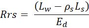
Where ρs is a constant that accounts for sea surface roughness, sensor viewing geometry, and the direct and diffuse fractions of downwelling sky irradiance (Simis and Olsson, 2013). The ρs constant was set to 0.028, following Mobley (1999), who determined this as the optimal value for view angles between 30 and 40 degrees. This calculation removes the sky radiance contribution to the measured water-leaving radiance and normalizes it to the solar (downwelling) irradiance. Finally, Rrs data were screened for a second sunglint removal by removing all Rrs values where [Rrs at 582 nm / Rrs at 678 nm] > 200 Simis and Olsson (2013).
Data Access
These data are available through the Oak Ridge National Laboratory (ORNL) Distributed Active Archive Center (DAAC).
SHIFT: Ramses Trios Radiometer Above Water Measurements, Santa Barbara Sea, CA
Contact for Data Center Access Information:
- E-mail: uso@daac.ornl.gov
- Telephone: +1 (865) 241-3952
References
Mobley, C.D. 1999. Estimation of the remote-sensing reflectance from above-surface measurements. Applied Optics 38:7442-7455 https://doi.org/10.1364/AO.38.007442
Simis, S.G.H., and J. Olsson. 2013. Unattended processing of shipborne hyperspectral reflectance measurements. Remote Sensing of Environment 135:202–212. https://doi.org/10.1016/j.rse.2013.04.001