Documentation Revision Date: 2017-09-15
Data Set Version: 1
Summary
The model (model B) used for these calculations was based on a stepwise linear multiple regression of individual aggregated records of geographically referenced data on daily and/or monthly rates of CO2 flux rates from intact soils, temperature, precipitation, potential evapotranspiration, vegetation type, soil moisture status, and organic carbon and nitrogen contents of soil.
There are 14 data files in ASCII format (.dat) with this data set. This includes 12 data files (one for each month), one annual file of summed CO2 emissions, and one land-water mask. In addition, maps of the soil emissions are provided as companions in .gif format, one for each monthly file and one for the annual emissions file.
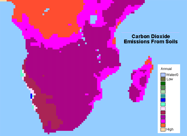
Figure 1. Estimated annual CO2 emissions from soils in South Africa.
Citation
Raich, J.W., and C.S. Potter. 2017. SAFARI 2000 Monthly and Annual CO2 Emissions from Soil, 0.5 Degree Grid. ORNL DAAC, Oak Ridge, Tennessee, USA. https://doi.org/10.3334/ORNLDAAC/644
Table of Contents
- Data Set Overview
- Data Characteristics
- Application and Derivation
- Quality Assessment
- Data Acquisition, Materials, and Methods
- Data Access
- References
- Data Set Revisions
Data Set Overview
The data set provides estimated monthly and annual soil CO2 emissions from southern Africa. The calculated emissions are from the respiration of both soil organisms and plant roots and are provided on a 0.5-degree grid cell basis.
The model (model B) used for these calculations was based on a stepwise linear multiple regression of individual aggregated records of geographically referenced data on daily and/or monthly rates of CO2 flux rates from intact soils, temperature, precipitation, potential evapotranspiration, vegetation type, soil moisture status, and organic carbon and nitrogen contents of soil.
The data are a subset of a global data set (Raich and Potter, CDIAC 1996), reformatted and subsetted to the SAFARI region.
Project: SAFARI 2000
The Southern African Regional Science Initiative (SAFARI 2000) project was an international science initiative to study the linkages between land and atmosphere processes conducted from 1999-2001 in the southern African region. In addition, SAFARI 2000 examined the relationship of biogenic, pyrogenic, and anthropogenic emissions and the consequences of their deposition to the functioning of the biogeophysical and biogeochemical systems of southern Africa.
Related Data Set:
Raich, J.W., and W.H. Schlesinger. 2002. SAFARI 2000 Annual Soil Respiration Data (Raich and Schlesinger 1992). ORNL DAAC, Oak Ridge, Tennessee, USA. https://doi.org/10.3334/ORNLDAAC/645
Data Characteristics
Spatial Coverage: Southern Africa
Spatial Resolution: 0.5-degree gridded data
Temporal Coverage: 19950101 to 19951231
Temporal Resolution: Monthly and annual
Study Area (All latitude and longitude given in decimal degrees)
| Site | Westernmost Longitude | Easternmost Longitude | Northernmost Latitude | Southernmost Latitude |
|---|---|---|---|---|
| Southern Africa | 5 | 60 | -5 | -35 |
Data File Information
There are 14 data files with this data set in ASCII format (.dat). This includes one land-water mask, one file of estimated annual soil CO2 emissions, and 12 files of estimated monthly soil CO2 emissions. The data are provided in units of 100 grams carbon per square meter of soil area. The data are on a 0.5-degree grid.
Maps of the soil emissions are provided in .gif format, as granule companions, one for each monthly file and one for the annual emissions file. The FORTRAN code used to read the original global data files is also provided as a companion file and is available in the global data set documentation (Raich and Potter, CDIAC 1996).
Table 1. File names
| File name | Description |
|---|---|
| safari2k_landmask.dat | Land-water mask |
| safari2k_rpmodb_ann.dat | Summed annual CO2 emissions |
| safari2k_rpmodb_xxx.dat | Twelve files of monthly CO2 emissions where xxx = abbreviated months of jan through dec |
| Companion files | Description |
| safari_rpmodb_annual.gif | Image associated with the data file safari2k_rpmodb_ann.dat |
| safari_rpmodb_xxx.gif | Images associated with each of the data files named safari2k_rpmodb_xxx.dat |
| safari_FORTRAN_CODE.pdf | FORTRAN code used to read the original global data files |
| s2k_soil_respiration_gridded.pdf | A pdf of this guide document |
Table 2. Example data for the month of May, data file safari2k_rpmodb_may.dat
The first six rows in the files provide the number of columns, number of rows, x and y bounding box coordinates, grid cell size, and no data value. Data values begin on line 7.
| ncols 110 nrows 80 xllcorner 5 yllcorner -35 cellsize 0.5 NODATA_value -9999 11892 11741 11607 11579 11491 11333 11180 10697 10291 10538 10528 10278 10281 10148 9944 9897 9946 10020 10108 10108 10006 9969 10056 10267 10452 10488 10307 9998 9854 10020 10409 10726 10849 10794 10730 10647 10467 10529 10584 10534 10476 10450 10446 10404 10317 10220 10249 10231 10143 10046 10042 10159 10414 10474 10472 10149 9072 8048 8066 8819 9258 9222 8987 8746 8400 8232 8275 8302 8283 8253 8177 8331 8695 8984 9589 10054 10187 10184 10321 10557 10592 10385 10088 9811 9766 0 0 0 0 0 0 0 0 0 0 0 0 0 0 0 0 0 0 0 0 0 0 0 0 0 0 0 0 0 0 0 0 |
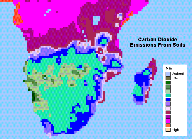
Figure 2. Estimated CO2 emissions for the month of May in South Africa. This is the data file companion safari_rpmodb_may.png associated with the data file safari2k_rpmodb_may.dat.
Application and Derivation
These data could be of value in carbon cycle modeling.
Quality Assessment
The following summarizes the QA checks performed by CDIAC on the Model B output presented in the data files:
1) To get correct latitude/longitude locations for soil emissions the predicted emissions were plotted over maps of vegetation types at the one degree grid cell level by Matthews (1985), and on the half degree grid cell level by Post et. al. (1996), and Olsen et al. (CDIAC, 1985). For the soil emission plots the 0.5 degree latitude band containing the Greenwich meridian and the 0.5 degree longitude band around the equator had to be skipped to achieve proper coastline alignment.
2) When Model B output per grid cell (g C/m2/yr or /month) was multiplied by grid cell area (m2) (calculated according to the program from the Goddard Institute for Space Studies (see IV)), and these products summed, total global soil emission was found to be 80.4 Pg C/yr while the published Model B value was 77.1 Pg C/yr (Table 1 & p 27 in Raich and Potter, 1995). Using the landmask information, provided by the authors, reduced the total global soil emission to 77.8 Pg C/yr.
3) The contributors of the model output (authors of the paper) were in agreement with CDIAC analysts about the necessity of reporting the above mentioned two points (Raich and Potter, CDIAC 1996).
Data Acquisition, Materials, and Methods
This data set provides estimated monthly and annual soil CO2 emissions for southern Africa (the SAFARI 2000 project region). The calculated emissions are from the respiration of both soil organisms and plant roots and are on on a 0.5-degree grid cell basis. The data are a subset of a global data set (Raich and Potter, CDIAC 1996), reformatted and subset to the SAFARI region. The methods used to derive the global data set are described followed by the method used to subset the data for South Africa.
Methods- global data set
The model (model B) used for these calculations was based on a stepwise linear multiple regression of individual aggregated records of geographically referenced data on daily and/or monthly rates of CO2 flux rates from intact soils, temperature, precipitation, potential evapotranspiration, vegetation type, soil moisture status, and organic carbon and nitrogen contents of soil. These data points represent grid cells from every continent except Antarctica. Temperature and soil moisture status, as predicted by precipitation, were the only variables significantly correlated with soil CO2 efflux. Temperature and precipitation were, therefore, used as driving variables. The remaining model parameters for the mechanistic aspect of the model are (1) the soil CO2 efflux rate when temperature is zero and moisture not limiting, (2) the temperature coefficient and (3) the half-saturation coefficient of the precipitation function. These were obtained using least squares estimates with both Quasi-Newton and Simplex methods. To prevent extrapolation of the model beyond the range of observed temperatures, soil CO2 fluxes were presumed to be zero at average monthly air temperatures less than -13.3 degrees Celsius, and for all temperatures greater than 33.5 degrees Celsius, soil CO2 fluxes were set equal to the rate predicted at 33.5 degrees Celsius (Raich and Potter, 1995).
Subsetting of the data for South Africa
The original (global) data were downloaded from CDIAC and the data were subsetted from this data set. Using GRID (a raster- or cell-based geoprocessing toolbox that is integrated with ArcInfo) the SETWINDOW command was used to define the subarea of interest which was defined by identifying the bounding coordinates: x_min 5 y_min -35 x_max 60 y_max 5.
Data Access
These data are available through the Oak Ridge National Laboratory (ORNL) Distributed Active Archive Center (DAAC).
SAFARI 2000 Monthly and Annual CO2 Emissions from Soil, 0.5 Degree Grid
Contact for Data Center Access Information:
- E-mail: uso@daac.ornl.gov
- Telephone: +1 (865) 241-3952
References
CDIAC 1996 (Revised for the web 2002). Global Patterns of Carbon Dioxide Emissions from Soils on a 0.5 Degree Grid Cell Basis. DB-1015. Contributed by James W. Raich and Christopher S. Potter. Available on-line from the Carbon Dioxide Information Analysis Center, Oak Ridge National Laboratory, Oak Ridge, Tennessee. http://dx.doi.org/10.3334/CDIAC/lue.db1015
Matthews, E. 1985. Atlas of Archived Vegetation, Land-Use and Seasonal Albedo Data Sets. Goddard Space Flight Center Institute for Space Studies. N.Y, N.Y.
Olson, J.S., J.A. Watts and L.J. Allison. 1985. Major World Ecosystem Complexes Ranked by Carbon in Live Vegetation: A Database. NDP017. Carbon Dioxide Information Analysis Center, Oak Ridge National Laboratory. Oak Ridge, Tennessee.
Post, W.M., A.W. King and S.D. Wullschleger, 1996. Soil Organic Matter Models and Global Estimates of Soil Organic Carbon. Nato ASI Series Vol 138: 201-222.DOI: http://dx.doi.org/10.1007/978-3-642-61094-3_14
Raich, J.W. and C.S. Potter. 1995. Global Patterns of Carbon Dioxide Emissions from Soils. Global Biogeochemical Cycles 9(1)23-36. DOI: http://dx.doi.org/10.1029/94GB02723
Data Set Revisions
Revision 1 of this data set includes 13 companion files in *.gif format, one image for each monthly data file and one for the annual emissions data file. In the original version, these images were available only through a custom viewer. There were no changes to the emissions data or respective images - only a re-packaging of the images as companion files.