Get Data
Summary:
This data set is derived from Russian forest fire imagery data from the National Forest Fire Center of Russia archive that were collected by the Center of Remote Sensing, Institute of Solar Terrestrial Physics, Irkutsk, Russia, for the 1998 and 1999 fire seasons. The data are vector (point) maps of forest fire locations (1998 and 1999) in ArcView shapefile format. Also included are graphic maps depicting fire locations (see Figure 1).
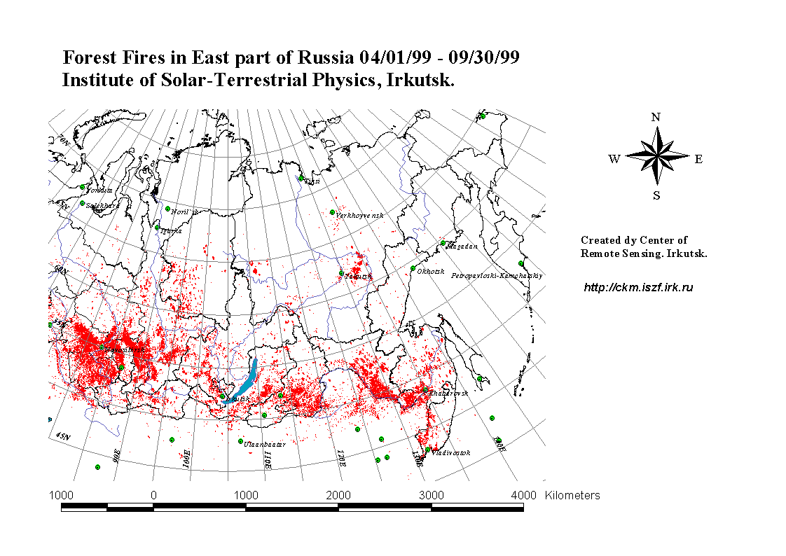
Figure 1. A graphic map depicting fire locations during the 1999 season.
Data Citation:
Cite this data set as follows:
Minko, N., T. A. Stone, and P. Schlesinger. 2003. RLC Forest Fire Locations in Eastern Russia, 1998-1999. Data set. Available on-line [http://www.daac.ornl.gov] from Oak Ridge National Laboratory Distributed Active Archive Center, Oak Ridge, Tennessee, U.S.A. doi:10.3334/ORNLDAAC/695.
Table of Contents:
- 1 Data Set Overview
- 2 Data Characteristics
- 3 Applications and Derivation
- 4 Quality Assessment
- 5 Acquisition Materials and Methods
- 6 Data Description and Access
- 7 References
- 8 Glossary and Acronyms
- 9 Document Information
1. Data Set Overview:
Data Set Contents:
This data set is derived from Russian forest fire imagery data from the National Forest Fire Center of Russia archive that were collected by the Center of Remote Sensing, Institute of Solar Terrestrial Physics, Irkutsk, Russia, for the 1998-1999 forest fire seasons.
Related Data Sets:
See other Russian Land Cover data sets.
Title of Investigation:
Measuring Changes to Russian Forest Over the Last 25 Years
Investigator(s) Name and E-mail:
| Name | |
|---|---|
| Stone, T.A. | tstone@whrc.org |
| Schlesinger, P. | pschles@whrc.org |
| Minko, N. | nick@iszf.irk.ru |
Technical Contact(s) Name, Telephone, and E-mail:
| Name | Phone | |
|---|---|---|
| Schlesinger, P. | pschles@whrc.org | (508)540-9900 |
Future Modifications and Plans:
Not available
2. Data Characteristics:
Study Area:
Eastern Russia
Temporal Coverage:
Forest fire seasons 1998-1999
Parameter or Variable:
Table for: erus98.tar.gz
| Variable | Description | Units | Instrument | Range |
|---|---|---|---|---|
| FIRE OCCURRENCE | Active fires | Unitless | AVHRR | Not applicable |
Table for: erus99.tar.gz
| Variable | Description | Units | Instrument | Range |
|---|---|---|---|---|
| FIRE OCCURRENCE | Active fires | Unitless | AVHRR | Not applicable |
Data Organization
Please read all companion documentation before using these files: http://daac.ornl.gov/daacdata/russian_land_cover/fire_sumpt/comp/fire_sum98_readme.txt and http://daac.ornl.gov/daacdata/russian_land_cover/fire_sumpt/comp/fire_sum99_readme.txt.
Granule Name or Description:
erus98.tar.gz
Data Format:
Vector (point) map of forest fire locations during the 1998 fire season in ArcView shapefile format (compressed). Points are attributed with date, lat/lon, and hour.
Sample Data Record:
Not applicable.
Granule Name or Description:
erus99.tar.gz
Data Format:
Vector (point) map of forest fire locations during the 1999 fire season in ArcView shapefile format (compressed). Points are attributed with date, lat/lon, and hour.
Sample Data Record:
Not applicable.
3. Application and Derivation:
Typical Application of Data
Regional-, national-, and sub-national-level forest and land use change assessments.
Theory of Measurements:
Not available
Derivation Techniques and Algorithms:
Source data are NOAA AVHRR data received by the Center of Remote Sensing, Institute of Solar Terrestrial Physics, Irkutsk, Russia. The Center's fire pixel algorithm determines the existence of active fires.
4. Quality Assessment:
Data Usage Guidance:
Errors and Limitations:
Error Sources:
Not available
Limitations of the Data:
Not available
Known Problems with the Data:
Not available
Quality Assessment Activities
Not available
Other Relevant Information about the Study:
Not available
5. Acquisition Materials and Methods:
Source or Platform Collection Environment:
NOAA satellites carrying AVHRR sensor
Source or Platform Program Management:
Not available
Source or Platform Mission Objectives:
Coverage Information:
Not available
Attitude Characteristics:
Not available
Data Collection System:
Not available
Communication Links:
Not available
List of Sensors or Instruments:
AVHRR
Ground Segment Information:
Data Acquisition and Processing:
Not available
Latitude Crossing Times:
Not available
Sensor or Instrument Descriptions
Key Variables:
Not available
Principles of Operation:
Not available
Sensor or Instrument Measurement Geometry:
Not available
Manufacturer of Sensor or Instrument:
Not available
Calibration:
Specifications:
Not applicable
Tolerance:
Not applicable
Frequency of Calibration:
Not applicable
Other Calibration Information:
Not applicable
Data Acquisition Methods:
The source data were acquired from the Center of Remote Sensing, Institute of Solar Terrestrial Physics, Irkutsk, Russia ( http://ckm.iszf.irk.r).
Observations
Data Notes:
6. Data Description and Access:
Data Access:
This data set is available from the Oak Ridge National Laboratory (ORNL) Distributed Active Archive Center (DAAC).
Data Archive Center:
Contact for Data Center Access Information:
E-mail: uso@daac.ornl.gov
Telephone: +1 (865) 241-3952
FAX: +1 (865) 574-4665
Product Availability:
Data can be accessed electronically on the ORNL DAAC's anonymous HTTP site or from the DAAC's search and order system. Data files are also available by request from uso@daac.ornl.gov.
Reading the Media:
Not available
Software and Analyses Tools:
Not available
7. References:
The published reference for the source data is as follows:
Not available
8. Glossary and Acronyms:
Glossary:
Not available
Acronyms:
| Acronym | Definition |
| AVHRR | Advanced Very High Resolution Radiometer |
| GIF | Graphic Image Format |
| NOAA | National Oceanic and Atmospheric Administration |
9. Document Information:
2003/11/22
Document Review Date:
2003/11/22
Document Curator:
webmaster@www.daac.ornl.gov