Documentation Revision Date: 2018-04-12
Data Set Version: 1
Summary
There are three data files in NetCDF (.nc4) format with this dataset.
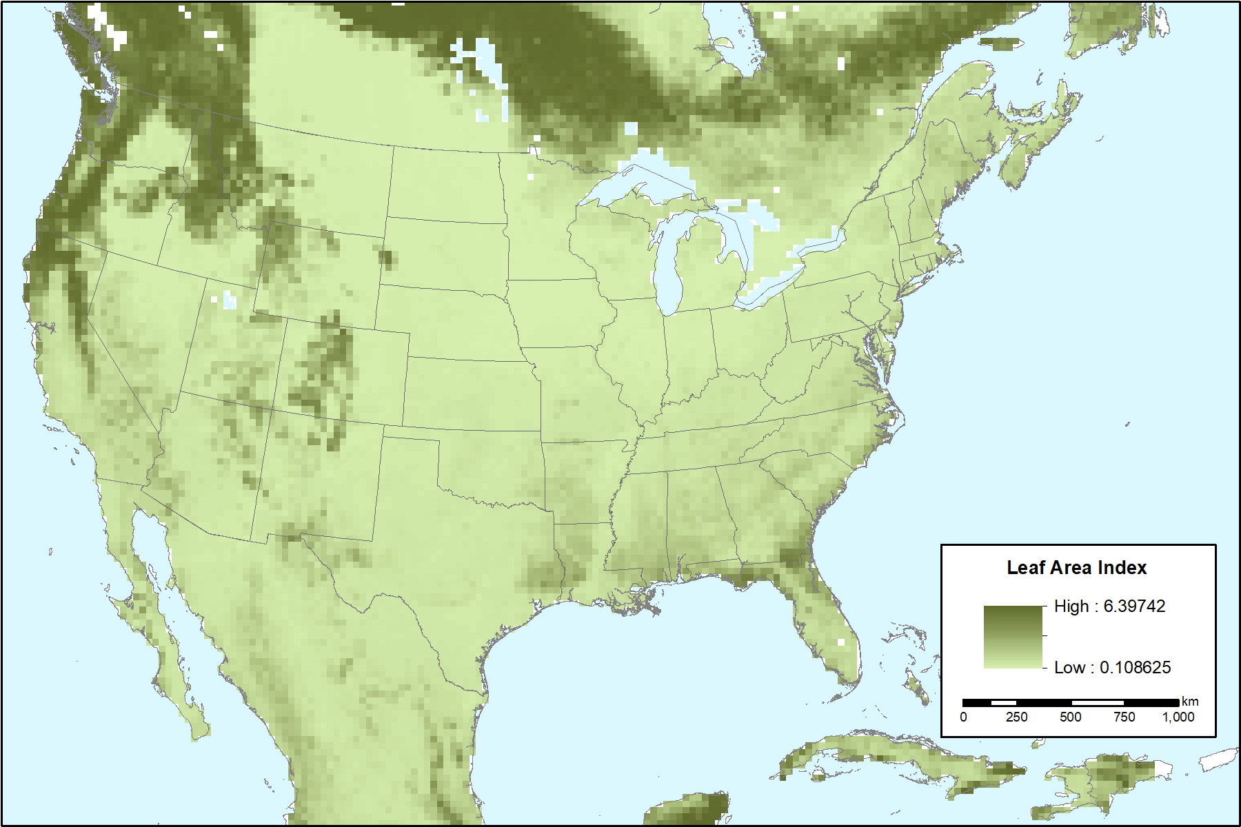
Figure 1. Leaf area index at 30 km resolution for the month of January. This figure was created from the data file leaf_stem_area_index_monthly_climatology_2003-2010.nc4.
Citation
Xu, M., X. Zhang, and X.Z. Liang. 2018. MODIS-derived Vegetation and Albedo Parameters for Agroecosystem-Climate Modeling. ORNL DAAC, Oak Ridge, Tennessee, USA. https://doi.org/10.3334/ORNLDAAC/1539
Table of Contents
- Data Set Overview
- Data Characteristics
- Application and Derivation
- Quality Assessment
- Data Acquisition, Materials, and Methods
- Data Access
- References
- Data Set Revisions
Data Set Overview
This dataset provides MODIS-derived leaf area index (LAI), stem area index (SAI), vegetation area fraction, dominant landcover category, and albedo parameters for the continental US (CONUS), parts of southern Canada, and Mexico at 30 km resolution. The data cover the period 2003-2010 and were developed to be used as surface input data for regional agroecosystem-climate models. MODIS Collection 5 products used to derive these parameters included the Terra yearly water mask, vegetation continuous field products, the combined Terra and Aqua yearly land-cover category (LCC) (MCD12Q1), 8-day composites (i.e., January 1-8, January 9-16, etc.) for LAI (MCD15A2), and albedo parameter (MCD43B1) products
Project: North American Carbon Program
The North American Carbon Program (NACP) is a multidisciplinary research program to obtain scientific understanding of North America's carbon sources and sinks and of changes in carbon stocks needed to meet societal concerns and to provide tools for decision makers. The NACP is supported by a number of different federal agencies. The central objective is to measure and understand the sources and sinks of Carbon Dioxide (CO2), Methane (CH4), and Carbon Monoxide (CO) in North America and in adjacent ocean regions.
Related Publication:
Xu, M., X-Z. Liang, A.N. Samel, and W. Gao. 2014. MODIS consistent vegetation parameter specifications and their impacts on regional climate simulations. J Clim 27:8578–8596. https://doi.org/10.1175/JCLI-D-14-00082.1
Acknowledgements:
The datasets are generated with support from NASA Terrestrial Ecology (TE NNH12AU03I) and New Investigator Program (NIP) (NNH13ZDA001N).
Data Characteristics
Spatial Coverage: Entire continental United States and partial regions of Canada and Mexico
Spatial resolution: 30 km x 30 km resolution
Temporal resolution: Climatology is average values for each month (12 time steps) representing data between 2003-01-01 to 2010-12-31. The “*_8day” data retain the original 8-day MODIS composite resolution.
Study Areas (All latitude and longitude given in decimal degrees)
| Site | Westernmost Longitude | Easternmost Longitude | Northernmost Latitude | Southernmost Latitude |
|---|---|---|---|---|
| USA and partial regions of Canada and Mexico | -139.0508333 | -51.94888889 | 49.1525 | 15.1525 |
Data File Information
There are three files in netCDF (.nc4) format with this data set: one file with albedo parameters (data every 8 days), one file with stem and leaf area index (data every 8 days), and one file with monthly leaf area and stem area index, dominant land cover, and vegetation area fraction data. The data are provided at 30-km resolution that is generally useful for most RCMs.
Table 1. File names and descriptions
| File name | Descriptions |
|---|---|
| infrared_visible_bands_8day_2003-2010.nc4 | Provides 8-day albedo parameters -- the LiSparseR, Isotropic, and Rossthick parameters for near-infrared band (0.3-5um) and for visible band (0.3-0.7um). Temporal extent: Every 8 days from 2003-01-01 to 2010-12-31. |
| leaf_stem_area_index_8day_2003-2010.nc4 | Provides 8-day leaf area index and stem area index. Temporal extent: Every 8 days from 2003-01-01 to 2010-12-31. |
| leaf_stem_area_index_monthly_climatology_2003-2010.nc4 | Provides monthly average over years 2003 to 2010 of leaf area and stem area index, dominant land cover, and vegetation area fraction data |
Data Variables
Table 2. Variables in the file infrared_visible_bands_8day_2003-2010.nc4.
| Variable | Units | Description* |
|---|---|---|
| fngeo | none | LiSparseR parameter for near-infrared band (0.3-5um) |
| fniso | none | Isotropic parameter for near-infrared band (0.3-5um) |
| fnvol | none | Rossthick parameter for near-infrared band (0.3-5um) |
| fvgeo | none | LiSparseR parameter for visible band (0.3-0.7um) |
| fviso | none | Isotropic parameter for visible band (0.3-0.7um) |
| fvvol | none | Rossthick parameter for visible band (0.3-0.7um) |
*These albedo parameters are discussed in Schaaf et al. 2002.
Table 3. Variables in the file leaf_stem_area_index_8day_2003-2010.nc4.
| Variable | Units | Description |
| lai | none | Leaf area index |
| sai | none | Stem area index |
Table 4. Variables in the file leaf_stem_area_index_monthly_climatology_2003-2010.nc4
| Variable | Units | Description |
|---|---|---|
| XFVEG | none | Vegetation area fraction |
| XLAI | none | Leaf area index |
| XLCC | none | Dominant land cover category: USGS 24-category Land Use Categories. See Table 5 below. |
| XSAI | none | Stem area index |
Table 5. USGS 24-category Land Use Categories.
| Land Use Category | Land Use Description* |
|---|---|
| 1 | Urban and Built-up Land |
| 2 | Dryland Cropland and Pasture |
| 3 | Irrigated Cropland and Pasture |
| 4 | Mixed Dryland/Irrigated Cropland and Pasture |
| 5 | Cropland/Grassland Mosaic |
| 6 | Cropland/Woodland Mosaic |
| 7 | Grassland |
| 8 | Shrubland |
| 9 | Mixed Shrubland/Grassland |
| 10 | Savanna |
| 11 | Deciduous Broadleaf Forest |
| 12 | Deciduous Needleleaf Forest |
| 13 | Evergreen Broadleaf |
| 14 | Evergreen Needleleaf |
| 15 | Mixed Forest |
| 16 | Water Bodies |
| 17 | Herbaceous Wetland |
| 18 | Wooden Wetland |
| 19 | Barren or Sparsely Vegetated |
| 20 | Herbaceous Tundra |
| 21 | Wooded Tundra |
| 22 | Mixed Tundra |
| 23 | Bare Ground Tundra |
| 24 | Snow or Ice |
*Source: WRF user's guide: http://www2.mmm.ucar.edu/wrf/users/docs/user_guide_V3/users_guide_chap3.htm
Data file projection
These files use a custom projection:
| PROJCS["custom", |
| GEOGCS["WGS 84", |
| DATUM["WGS_1984", |
| SPHEROID["WGS 84",6378137,298.257223563, |
| AUTHORITY["EPSG","7030"]], |
| AUTHORITY["EPSG","6326"]], |
| PRIMEM["Greenwich",0], |
| UNIT["degree",0.0174532925199433], |
| AUTHORITY["EPSG","4326"]], |
| PROJECTION["Lambert_Conformal_Conic_2SP"], |
| PARAMETER["standard_parallel_1",30], |
| PARAMETER["standard_parallel_2",60], |
| PARAMETER["latitude_of_origin",37.5], |
| PARAMETER["central_meridian",-95.5], |
| PARAMETER["false_easting",0], |
| PARAMETER["false_northing",0], |
| UNIT["metre",1, |
| AUTHORITY["EPSG","9001"]]] |
| Proj4 string: |
| +proj=lcc +lat_1=30 +lat_2=60 +lat_0=37.5 +lon_0=-95.5 +x_0=0 +y_0=0 +datum=WGS84 +units=m +no_defs |
Application and Derivation
These data were developed to replace the AVHRR-derived vegetation parameters for use as surface input data for regional climate models (Xu et al., 2014).
Quality Assessment
Use these data with caution: No quality assessment is provided. The uncertainties are expected to partially inherit from the original MODIS data products.
Please note that the MODIS Version 5 land data products used in this dataset have been superseded by Version 6 data products.
Known Issues: The albedo parameter (V005 MCD43B1) product used here only represents the average of the underlying MCD43A product (with the majority QA) and thus is considered a poorer quality product. MCD43B was discontinued in V006. In V006, MCD43A* represents the primary retrieval for this product and is recommended for all users. The MCD43D* products are provided on a 30arc second Climate Modeling Grid (CMG) and are recommended for use in climate simulation models. As with all MODIS products, we recommend you use these data only with a complete understanding of the associated QA flags.
Data Acquisition, Materials, and Methods
Overview:
This dataset provides vegetation parameters (LAI, SAI, FVC, and LCC) and albedo parameters derived from MODIS Collection 5 data products for use in regional agroecosystem-climate models.. The MODIS Collection 5 data used to derive the vegetation parameters were the Terra yearly water mask and vegetation continuous field products, and the combined Terra and Aqua yearly LCC (MCD12Q1), 8-day composites for LAI (MCD15A2), and albedo parameter (MCD43B1) products.
The products were first aggregated from their original spatial resolutions to a 1-km sinusoidal projection and then remapped using a nearest-neighbor interpolation to a 1-km map projection within a computation domain defined by users. Pixels were processed only where the embedded quality control (QC) flag indicates best quality. The remaining pixels were assigned a missing value. To remove the missing value pixels and minimize cloud and snow contamination, multiyear data were used to construct a monthly climatology of yearly data and the 8-day composites. The processing of the MODIS products are described in detail in Xu et al. (2014).
Important User Notes:
Date Range: The detailed processing described in Xu et al. (2014) refer to MODIS data products over the date range of 2000-2010. The data provided in this dataset are a subset from 2003-2010. The data prior to 2003 are generally of poor quality and have many missing values and were excluded.
Spatial Resolution: The detailed processing in Xu et al. (2014) describe various conversions and reprojections of the data for comparisons with other products and to accommodate specific regional agroecosystem-climate models. The data provided in this dataset are an aggregation of the 1-km products to a 30-km resolution that is generally useful for most regional agroecosystem-climate models..
Detailed Processing Descriptions:
The data user is referred to Xu et al. (2014) for complete processing details for the land-cover category (LCC), fractional vegetation cover (FVC), leaf and steam area indices (LAI and SAI), and land surface albedo parameters.
Data Access
These data are available through the Oak Ridge National Laboratory (ORNL) Distributed Active Archive Center (DAAC).
MODIS-derived Vegetation and Albedo Parameters for Agroecosystem-Climate Modeling
Contact for Data Center Access Information:
- E-mail: uso@daac.ornl.gov
- Telephone: +1 (865) 241-3952
References
Schaaf, C. B., Gao, F., Strahler, A. H., Lucht, W., Li, X., Tsang, T., et al. (2002). First operational BRDF, albedo nadir reflectance products from MODIS. Remote Sensing of Environment, 83(1–2), 135–148. https://doi.org/10.1016/S0034-4257(02)00091-3
Xu, M., X-Z. Liang, A.N. Samel, and W. Gao. 2014. MODIS consistent vegetation parameter specifications and their impacts on regional climate simulations. J Clim 27:8578–8596. https://doi.org/10.1175/JCLI-D-14-00082.1
Data Set Revisions
This dataset documentation was revised on 2018-04-10 to indicate known data quality issues with the MODIS Version 5 MCD43B data product.