Get Data
Summary:
The data set provides a 30-m comprehensive fuelbed characteristics map for both the wildland and cropland areas of the conterminous United States (CONUS) for 2010. This integrated product is the result of combining the spatially discrete Fuel Characteristic Classification System (FCCS) data of the US Forest Service (USFS) with the crop-and grassland-specific information of the US Department of Agriculture’s (USDA's) Cropland Data Layer (CDL).
There are three GeoTIFF format files and three comma-separated companion files distributed with this data set. The three tif files provided are very large and exceed the size limits of a standard GeoTIFF file format (4 GB). File sizes range from 20 to 30 GB. Compressed file sizes range from 2 to 3 GB. They are in a format that is called a BigTIFF file. ArcGIS 10.0 and ERDAS Imagine are able to read these files.
- The CDL product (cdl_conus_2010.tif) is a spatially continuous discrete raster file of the CDL for 2010 at a 30-m spatial resolution for the CONUS area. This file is a mosaicked data set of individual state CDL layers provided annually by the USDS National Agricultural Statistics Service and contains 126 cropland and other vegetative classes. The Vegetative Code classes for the CDL layer are distributed in the companion file CDL-FCCS_Crosswalk.csv.
- The FCCS product is a discrete raster layer at a 30-m spatial resolution for 2010 that provides fuelbed component information used in the FCCS developed by the USFS from US Geological Survey (USGS) Landfire project base data (see description at the USFS FCCS web site (www.landfire.gov). This layer is unique to this data set because it is at 30-m resolution and the one provided by the Forest Service to the public is at 1-km resolution. Fuelbed Codes are provided in the comma-separated companion file- FuelbedCodes.csv.
- The merged product, cdl_fccs_merge_2010.tif, is a raster file that is a combination of the CDL_2010 raster file and the FCCS raster file. This file is at a 30-m spatial resolution and covers the CONUS area of the United States. The merged file retains spatial and classification details of vegetative fuelbed characteristics provided by the FCCS file, while being enhanced by the crop and grassland details provided in the CDL layer. The logic of the merging process is provided in Section 5 and a table of numeric code value descriptions and CDL-to-FCCS matching is provided in the comma-separated companion file CDL-FCCS_Crosswalk.csv.
This data set provides a 30-m comprehensive fuelbed map for both the wildland and cropland areas of the conterminous United States. By combining the spatially discrete details of the FCCS data set with the crop-and grassland-specific information of the CDL, a more robust map of fuelbed characteristics is available. The merged product has an advantage over the original FCCS map for estimating emissions from burned areas due to the integration of the fuelbed characteristics for agricultural areas from the CDL.
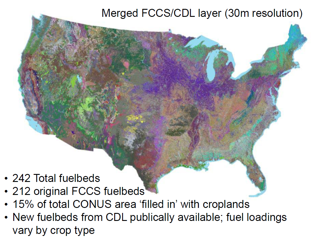
Figure 1. A mosaic image of the merged FCCS/CDL layer for the CONUS with characteristics as noted (French et al., 2012).
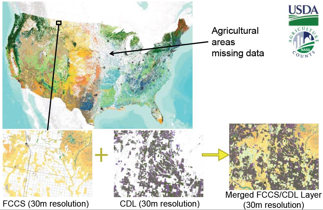
Figure 2. Common subsets of (a) FCCS 30m product, (b) CDL2010 30m product, and (c) merged product. Images demonstrate the filling in of gaps with the Cropland Data Layer (French et al., 2012).
Acknowledgements
The data used in this product are derived from the USFS's FCCS map, which is based off of the USGS Landfire program (http://landfire.gov), and from the USDA Cropland Data Layer (http://nassgeodata.gmu.edu/CropScape) product. Processing of these base data into the final product was performed at MTRI under grant funds from the NASA Earth System Science Carbon Cycle Science Program Grant #NNX08AK69G.
Data and Documentation Access:
Get Data: http://daac.ornl.gov/cgi-bin/dsviewer.pl?ds_id=1163
Description and Links to Additional Supplemental Information: None
Data Citation:
Cite this data set as follows:
French, N.H.F., D. McKenzie, N. Hamermesh, and J. McCarty. 2013. NACP Integrated Wildland and Cropland 30-m Fuel Characteristics Map, U.S.A., 2010. Data set. Available on-line [http://daac.ornl.gov] from ORNL DAAC, Oak Ridge, Tennessee, U.S.A. http://dx.doi.org/10.3334/ORNLDAAC/1163
Table of Contents:
- 1 Data Set Overview
- 2 Data Characteristics
- 3 Applications and Derivation
- 4 Quality Assessment
- 5 Acquisition Materials and Methods
- 6 Data Access
- 7 References
1. Data Set Overview:
Project: NACP
The files provided by the Integrated Wildland and Cropland Fuel Characteristics dataset provide a high-resolution (30-m) comprehensive fuelbed map for both the wildland and cropland areas of the CONUS. By combining the spatially discrete details of the Fuel Characteristic Classification System (FCCS) data set with the crop-and grassland-specific information of the Cropland Data Layer (CDL), a more robust map of fuelbed characteristics is available.
2. Data Characteristics:
This data set provides the following three GeoTIFF format files. The three tif files provided are very large and exceed the size limits of a standard GeoTIFF file format (4 GB). File sizes range from 20 to 30 GB. Compressed file sizes range from 2 to 3 GB. They are in a format that is called a BigTiff file. ArcGIS 10.0 and ERDAS Imagine are able to read these files.
The BigTIFF format files have been tarred and zipped for distribution (*.tar.gz). Even so, the compressed file sizes range from 2 to 3 GB. When extrapolated, the *.tar.gz files contain the *.tif format file and three auxiliary files: *.tif.aux.xml, *.tif.ovr, and *.tif.vat.dbf.
1) cdl_conus_2010.tar.gz: expands to
cdl_conus_2010.tif
• A 30-m continuous discrete raster file of the Cropland Data Layer for year 2010 mosaicked from individual state layers.
• BigTIFF file format
• File spatial details
#col: 199,591
#rows: 105,083
Data Type: 8 bit unsigned integer
Cellsize: 30m x 30m
NoData Value: 256
Spatial Reference:
Projection: Albers Conical Equal Area
false_easting: 0.000000
false_northing: 0.000000
central_meridian: -96.000000
standard_parallel_1: 29.500000
standard_parallel_2: 45.500000
latitude_of_origin: 23.000000
Linear Unit: Meter (1.000000)
Geographic Coordinate System: GCS_North_American_1983
Angular Unit: Degree (0.017453292519943295)
Prime Meridian: Greenwich (0.000000000000000000)
Datum: D_North_American_1983
Spheroid: GRS_1980
Semimajor Axis: 6378137.000000000000000000
Semiminor Axis: 6356752.314140356100000000
Inverse Flattening: 298.257222101000020000
2) fccs_30m.tar.gz: expands to
fccs_30m.tif
• A 30-m continuous discrete raster file of vegetative classes of the FCCS covering
the conterminous United States.
• BigTiff file format
• File spatial details
#col: 154,310
#rows: 97,646
Data Type: 16 bit signed integer
Cellsize: 30m x 30m
NoData Value: 32767
Spatial Reference:
Projection: Albers Conical Equal Area
false_easting: 0.000000
false_northing: 0.000000
central_meridian: -96.000000
standard_parallel_1: 29.500000
standard_parallel_2: 45.500000
latitude_of_origin: 23.000000
Linear Unit: Meter (1.000000)
Geographic Coordinate System: GCS_North_American_1983
Angular Unit: Degree (0.017453292519943295)
Prime Meridian: Greenwich (0.000000000000000000)
Datum: D_North_American_1983
Spheroid: GRS_1980
Semimajor Axis: 6378137.000000000000000000
Semiminor Axis: 6356752.314140356100000000
Inverse Flattening: 298.257222101000020000
2) cdl_fccs_merge2010.tar.gz:
expands to cdl_fccs_merge2010.tif
• An integrated map that combines the cropland vegetation details of the CDL file with the details of the wild land vegetative types of the FCCS data
• BigTiff file format
• File spatial details
#col: 154,310
#rows: 97,646
Data Type: 16 bit unsigned integer
Cellsize: 30m x 30m
NoData Value: 32767
Spatial Reference:
Projection: Albers Conical Equal Area
false_easting: 0.000000
false_northing: 0.000000
central_meridian: -96.000000
standard_parallel_1: 29.500000
standard_parallel_2: 45.500000
latitude_of_origin: 23.000000
Linear Unit: Meter (1.000000)
Geographic Coordinate System: GCS_North_American_1983
Angular Unit: Degree (0.017453292519943295)
Prime Meridian: Greenwich (0.000000000000000000)
Datum: D_North_American_1983
Spheroid: GRS_1980
Semimajor Axis: 6378137.000000000000000000
Semiminor Axis: 6356752.314140356100000000
Inverse Flattening: 298.257222101000020000
Companion Files:
1) CDL-FCCS_Crosswalk.csv
• Describes the vegetative code classes for the CDL layer as well
as how the vegetation codes for the CDL layer were crosswalked to FCCS codes.
2) FuelbedCodes.csv
• Describes vegetation codes for the fuelbeds found in the integrated CDL-FCCS data file
3) Double_crop_codes.csv
• Describes vegetation codes for the double-cropped areas found in the integrated CDL-FCCS data file
GeoTIFF file viewing guidance:
To view the data in most GIS and image processing software packages, statistics need to be calculated for each raster file. For example, using ESRI's ArcCatalog, right click the GeoTIFF raster image and choose 'build statistics'.
Site boundaries: (All latitude and longitude given in decimal degrees)
| Site (Region) | Westernmost Longitude | Easternmost Longitude | Northernmost Latitude | Southernmost Latitude | Geodetic Datum |
|---|---|---|---|---|---|
| Conterminous United States | -126.46 | -67.96 | 49.79 | 26.52 | World Geodetic System, 1984 (WGS-84) |
Time period:
- The data set covers the period 2010
3. Data Application and Derivation:
The merged product has the advantage over the original Fuel Characteristic Classification System (FCCS) map for estimating emissions from burned areas due to the integration of the fuelbed characteristics for agricultural areas from the Cropland Data Layer (CDL).
Original FCCS map does not include all land types with vegetation fuels:
– Missing types primarily are areas that are urban, bare, or agricultural
– When fires occur in these areas, CONSUME calculates their emissions as 0
– Fires do often occur in agricultural areas
Solution:
– The CDL contains detailed information about agricultural fuelbeds in many areas within the FCCS gaps
– Using ERDAS Imagine Model Maker, we merge the CDL with the FCCS to create an integrated fuelbed map
–Create new agricultural fuelbeds, reclassify CDL merge giving priority to FCCS in areas where the
CDL is vague (e.g. Deciduous Forest) and giving priority to the CDL in all other locations
4. Quality Assessment:
No quality assessment on this merged product has been performed. The QA for base data sets can be reviewed at the web sites of the originating data sets.
5. Data Acquisition Materials and Methods:
The Cropland Data Layer (CDL) provided is unique in that we mosaicked the state CDL layers together to form a continuous CONUS CDL layer.
The FCCS layer is unique because it is a 30-m resolution and the one provided to the public is a 1-km resolution. A fuelbed reference list is available from the FCCS website: http://www.fs.fed.us/pnw/fera/fccs/fuelbed_references/fuelbed_references_2-14-2007.pdf.
Integrated wildland and Cropland Data Layer (CDL) Fuel Characteristic Classification System (FCCS) 30-m product
Geospatial Process:
- CDL2010 30-m product (see Source 1 below) was mosaicked to cover CONUS.
- CDL mosaic was reclassified given the attached crosswalk (CDL-FCCS_Crosswalk.csv) using ERDAS Imagine Model Maker.
- New FCCS fuelbeds (1200s) were created to account for agricultural burning.
- General non-cropland pixels within the CDL classes (e.g., "Deciduous Forest", “Evergreen Forest”) were reclassified to 0 so that existing FCCS fuelbeds would take priority in these areas.
- FCCS 30-m product (see Source 2 below) and CDL (reclassified) were layer-stacked using ERDAS Imagine.
Merge was conducted using the following logic (in ERDAS Imagine Model Maker):
IF CDL (reclassified) = 0 AND FCCS < 980*, THEN cdl_fccs_merge2010 = FCCS
IF CDL (reclassified) != 0 AND FCCS >= 980*, THEN cdl_fccs_merge2010 = CDL(reclassified)
IF CDL (reclassified) != 0 AND FCCS < 980*, THEN cdl_fccs_merge2010 = CDL(reclassified)
IF CDL (reclassified) = 0 AND FCCS >= 980*, THEN cdl_fccs_merge2010 = 0
IF cdl_fccs_merge2010 = 0 AND CDL(original) = 171, THEN cdl_fccs_merge2010 = 1262
This last step was added because there were some areas that were classified as "Grassland Herbaceous" in the original CDL that we wanted to fill in with a specific grassland type from the FCCS, but in some of the areas that were classified as "Grassland Herbaceous" they were also classified as agriculture in the FCCS. To account for this, in situations where a pixel was "Grassland Herbaceous" in the original CDL, but was NOT filled in by the FCCS and thus remained 0 in the merged layer, we assigned these pixels the value of 1262, which corresponds to the new fuelbed
called "Pasture/Grass." "Pasture/Grass" is a fuelbed based on the CDL classification by the same name.
* - In this FCCS layer, values above 980 signified agriculture and cropland. There was no 0 value, but rather a NoData value that was used only in areas outside of CONUS.
Agricultural Fuel Loadings Calculations:
The fuel load for each of the crop types found in the CONUS was calculated using the following equation:
Fuel Load = rdC
where r is the residue-to-crop ratio, d is the dry matter fraction, and C is the crop production. r, d, and C can be found for each crop type in
a variety of sources (see Sources 3 - 9 below).
Sources:
(1) Cropland Data Layer -
http://nassgeodata.gmu.edu/CropScape/
• 30-m resolution,
126 classes, put out by state annually by US US Department of Agriculture
(USDA) National Agricultural Statistics Service
(2) FCCS - http://www.fs.fed.us/ccrc/tools/fccs.shtml
• 30-m and 1-km
resolution products available, 217 classes, obtained from Don McKenzie, research
ecologist with the Pacific Wildland Fire Sciences Lab, US Forest Service
(3) US Environmental Protection Agency (EPA) 2011 Greenhouse Gases (GHG) Inventory - http://www.epa.gov/ghgreporting/ghgdata/2011data.html
(4) Penn State Cooperative Extension - http://extension.psu.edu/agronomy-guide/cm/tables/table-1-1-3
(5) USDA (2010) Quick Stats: U.S. & All States Data; Production and Area Harvested; 1990-2009. National Agricultural Statistics Service, U.S. Department of Agriculture. Washington, DC. U.S. Department of Agriculture, National Agricultural Statistics Service. Washington, D.C., Available online at, http://quickstats.nass.usda.gov/
(6) Switchgrass and Hay yield - http://www.uky.edu/Ag/CDBREC/introsheets/switchgrass.pdf
(7) Bluegrass seed yield/DM ratio - http://www.ecy.wa.gov/programs/air/aginfo/research_pdf_files/FinalKBGEmissionStudyReport_4504.pdf
(8) Potatoes yield - http://usda.mannlib.cornell.edu/MannUsda/viewDocumentInfo.do?documentID=1124
(9) Sugar beets yield - http://usda.mannlib.cornell.edu/usda/nass/CropProdSu//2010s/2011/CropProdSu-01-12-2011_revision.pdf
6. Data Access:
This data is available through the Oak Ridge National Laboratory (ORNL) Distributed Active Archive Center (DAAC).
Data Archive Center:
Contact for Data Center Access Information:
E-mail: uso@daac.ornl.gov
Telephone: +1 (865) 241-3952
7. References:
Note: The Sources listed in Section 5 are the references for this data set.
French, Nancy H.F., Don McKenzie, and Tyler Erickson. 2012. Wildland Fire Emissions Information System for retrospective fire emissions mapping for North America. Presented at the 2012 ACCENT-IGAC-GEIA Conference, 11-13 June, Toulouse, France.