Documentation Revision Date: 2023-10-18
Dataset Version: 1
Summary
A future version of this dataset will include output for the related ecosystem models ED2, LINKAGES, LPJ-GUESS, LPJ-WSL, and TRIFFID. Owing to computational constraints, output for the entire region is available only for LPJ-GUESS and LPJ-WSL. For the models ED2, LINKAGES, and TRIFFID, a systematically-distributed subset of 254 grid cells is available. Output is also available for six individual sites and includes the added models CLM-BGC, CLM-CN, ED2-LU, JULES, and SiBCASA. The model output, as submitted, is available upon request.
There are 98 data files in netCDF-4 (*.nc4) format included in this dataset.
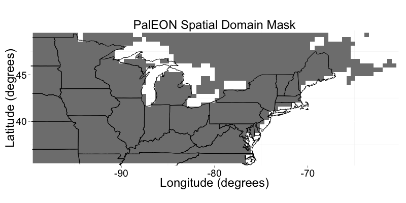
Figure 1. The spatial extent of the dataset.
Citation
Rollinson, C., M. Dietze, J.H. Mathes, J. Steinkamp, T. Hickler, B. Poulter, A.M. Raiho, J. Mclachlan, T. Quaife, Y. Liu, D.J.P. Moore, K. Schaefer, and B. Brooks. 2023. PalEON: Terrestrial Ecosystem Model Drivers for the Northeastern U.S., 0850-2010. ORNL DAAC, Oak Ridge, Tennessee, USA. https://doi.org/10.3334/ORNLDAAC/1779
Table of Contents
- Dataset Overview
- Data Characteristics
- Application and Derivation
- Quality Assessment
- Data Acquisition, Materials, and Methods
- Data Access
- References
Dataset Overview
This dataset from the PalEON Ecosystem Model Intercomparison Project (PEMIP) provides harmonized regional environmental and meteorological drivers at a resolution of 0.5 degrees for the North-central and Northeastern U.S. over the time period 0850-01-01 to 2010-12-31. This dataset consists of the regional environmental and meteorological drivers. The environmental drivers include (1) dominant biome type, (2) plant functional type, (3) annual carbon dioxide concentration, (4) monthly carbon dioxide concentration, (5) land use-land cover change, (6) nitrogen concentrations, and (7) soil measurements. The meteorological drivers include (1) incident longwave radiation, (2) incident shortwave radiation, (3) precipitation, (4) surface pressure, (5) specific humidity, (6) air temperature, and (7) wind speed. The PEMIP is a coordinated effort to develop a set of terrestrial ecosystem model simulations with the ability to evaluate high-resolution ecophysiological causes and consequences of forest responses to climatic variability and change over the past millennium.
A future version of this dataset will include output for the related ecosystem models ED2, LINKAGES, LPJ-GUESS, LPJ-WSL, and TRIFFID. Owing to computational constraints, output for the entire region is available only for LPJ-GUESS and LPJ-WSL. For the models ED2, LINKAGES, and TRIFFID, a systematically-distributed subset of 254 grid cells is available. Output is also available for six individual sites and includes the added models CLM-BGC, CLM-CN, ED2-LU, JULES, and SiBCASA. The model output, as submitted, is available upon request.
Project: North American Carbon Program
The North American Carbon Program (NACP) is a multidisciplinary research program designed to improve understanding of North America's carbon sources, sinks, and stocks. The central objective is to measure and understand the sources and sinks of Carbon Dioxide (CO2), Methane (CH4), and Carbon Monoxide (CO) in North America and adjacent oceans. The NACP is supported by a number of different federal agencies.
Related Dataset
Ramankutty, N., J.A. Foley, F.G. Hall, G.J. Collatz, B.W. Meeson, S.O. Los, E.Brown De Colstoun, and D.R. Landis. 2010. ISLSCP II Potential Natural Vegetation Cover. ORNL DAAC, Oak Ridge, Tennessee, USA. https://doi.org/10.3334/ORNLDAAC/961
Wei, Y., Shishi Liu, D.N. Huntzinger, A.M. Michalak, N. Viovy, W.M. Post, C.R. Schwalm, K. Schaefer, A.R. Jacobson, C. Lu, H. Tian, D.M. Ricciuto, R.B. Cook, J. Mao, and X. Shi. 2014. NACP MsTMIP: Global and North American Driver Data for Multi-Model Intercomparison. ORNL DAAC, Oak Ridge, Tennessee, USA. https://doi.org/10.3334/ORNLDAAC/1220
Related Publication
Rollinson, C.R., A. Dawson, A. Raiho, J.W. Williams, M.C. Dietze, T. Hickler, S.T. Jackson, J. McLachlan, D.J.P. Moore, B. Poulter, T. Quaife, J. Steinkamp, and M. Trachsel. 2021. Forest responses to last-millennium hydroclimate variability are governed by spatial variations in ecosystem sensitivity. Ecology Letters, 24:498-508. https://doi.org/10.1111/ele.13667
Acknowledgments
This work was supported by the National Science Foundation PalEON MacroSystems Biology grants DEB-1241874, DEB-1241851, DEB-1241891, and DEB-1241930.
Data Characteristics
Spatial Coverage: North-central and Northeastern U.S.
Spatial Resolution: 0.5 degree
Temporal Coverage: 0850-01-01 to 2010-12-31 or once
Temporal Resolution: annual, monthly, 6-hour, or once
Study Area: Latitude and longitude are given in decimal degrees.
| Site | Northernmost Latitude | Southernmost Latitude | Easternmost Longitude | Westernmost Longitude |
|---|---|---|---|---|
| U.S. | 50 | 35 | -60 | -100 |
Data File Information
There are 98 data files in Climate and Forecast (CF) compliant netCDF-4 classic model (*.nc4) format included in this dataset. The files are named paleon-reg-<type>_<variable>_<time>, where
- paleon_reg is the PalEON regional data,
- <type> is the driver, either env (environmental) or met (meteorological),
- <variable> is the data measurement, and
- <time> is the temporal coverage or resolution (excluding data sampled once) and YYYY represents a four-digit year.
Table 1. File names and descriptions.
| File Names | Temporal Resolution | Description |
|---|---|---|
| paleon_reg-env-dri_biome_pft.nc | once | A one-time measurement of the dominant biome type and plant functional type in each grid cell. |
| paleon_reg-env-dri_co2_annual.nc4 | annual | Average carbon dioxide concentration per year. The entire domain uses the same source concentration from PMIP-3. |
| paleon_reg-env-dri_co2_monthly.nc4 | monthly | Average carbon dioxide concentration per month and MsTMIP seasonal variability. The entire domain uses the same source concentration from PMIP-3. |
| paleon_reg-env-dri_domain.nc4 | once | The spatial mask of the PalEON domain that all other data files should match. |
| paleon_reg-env-dri_lulcc.nc4 | annual | The fraction of land cover, land harvest, and land transition. |
| paleon_reg-env-dri_nitrogen.nc4 | annual | Annual nitrogen inputs derived from MsTMIP. |
| paleon_reg-env-dri_soil.nc4 | once | Annual soil inputs derived from MsTMIP. |
| paleon_reg-met-dri_lwdown_YYYY-YYYY.nc4 | 6-hour | Incident longwave radiation averaged over the time step of the forcing data. The base datasets include CCSM4 (Scenario R1i1P1) and CRUNCEP. |
| paleon_reg-met-dri_precipf_YYYY-YYYY.nc4 | 6-hour | The per unit area and time precipitation representing the sum of convective rainfall, stratiform rainfall, and snowfall. The base datasets include CCSM4 (Scenario R1i1P1) and CRUNCEP. |
| paleon_reg-met-dri_psurf_YYYY-YYYY.nc4 | 6-hour | Pressure at the surface. The base datasets include CCSM4 (Scenario R1i1P1) and CRUNCEP. |
| paleon_reg-met-dri_qair_YYYY-YYYY.nc4 | 6-hour | Specific humidity measured at the lowest level of the atmosphere. The base datasets include CCSM4 (Scenario R1i1P1) and CRUNCEP. |
| paleon_reg-met-dri_swdown_YYYY-YYYY.nc4 | 6-hour | Incident radiation in the shortwave part of the spectrum averaged over the time step of the forcing data. The base datasets include CCSM4 (Scenario R1i1P1) and CRUNCEP. |
| paleon_reg-met-dri_tair_YYYY-YYYY.nc4 | 6-hour | Air temperature measured at 2 meters from the surface. The base datasets include CCSM4 (Scenario R1i1P1) and CRUNCEP. |
| paleon_reg-met-dri_wind_YYYY-YYYY.nc4 | 6-hour | Wind speed measured with a vertical coordinate in height of 10 m. The base datasets include CCSM4 (Scenario R1i1P1) and CRUNCEP. |
Data File Details
- Generally, files contain 30 rows and 80 columns.
- Missing values are represented by "-9999".
- The Coordinate Reference System is “WGS84” (EPSG:4326), where +proj=longlat +datum=WGS84 +ellps=WGS84 +towgs84=0,0,0.
- Time is provided in "days since 0850-01-01".
- The calendar used is "360_Day" so all years are 360 days and divided into 30-day months. This is an important consideration when printing the data for the human-readable format to be correct.
Application and Derivation
Exposure to 21st-century climate change is expected to profoundly impact global forest composition, diversity, and structure, but the sensitivity of ecosystems to climate variability at multi-decadal to centennial time scales is poorly constrained by instrumental observations. Terrestrial ecosystem models used to forecast responses to climate change often have difficulty reproducing broad-scale and long-term responses to environmental variability, despite being well-grounded in empirical evidence and ecological theory. Moreover, there are several challenges that hinder the joint analysis and integration of terrestrial ecosystem models and palaeoecological data to better constrain modeled responses to climate variations at multi-decadal and longer timescales.
These data were used in the related publication by Rollinson et al. (2021), to establish the patterns of forest ecosystem and climate variability in the north-central and northeastern U.S. for the last millennium (850–1850 C.E.) and identify the mechanisms underpinning both forest ecosystem sensitivity and observed data-model discrepancies. A combination of data-model and model-model comparisons of palaeoclimatic and palaeoecological datasets was used (Fig. 2). The results indicate that at centennial timescales, spatial patterns in the variability of forest composition and biomass are regulated by ecological factors such as ecotonal position and complexity rather than climate exposure as defined by the local magnitude of climate variability.
Quality Assessment
No quality assessment is available for this version of the dataset.
Data Acquisition, Materials, and Methods
This version of the dataset includes the environmental and meteorological drivers of the models that have a consistent spatial extent, resolution, and coordinate reference system. A future version will supply the curated model outputs.
The PalEON (Paleo-Ecological Observatory Network) Ecosystem Model Intercomparison Project (PEMIP) is an interdisciplinary team of paleoecologists, ecological statisticians, and ecosystem modelers from across a number of institutions began in the early 1990s to provide an efficient mechanism for coordinating palaeoclimate modeling activities (Braconnot et al., 2021). The goal of the PEMIP is to reconstruct forest composition, fire regime, and climate in forests across the northeastern U.S. and Alaska over the past 2,000 years and use the results to drive and validate terrestrial ecosystem models.
This dataset consists of the regional environmental and meteorological drivers. The environmental drivers include (1) dominant biome type, (2) plant functional type, (3) annual carbon dioxide concentration, (4) monthly carbon dioxide concentration, (5) land use-land cover change, (6) nitrogen concentrations, and (7) soil measurements. The meteorological drivers include (1) incident longwave radiation, (2) incident shortwave radiation, (3) precipitation, (4) surface pressure, (5) specific humidity, (6) air temperature, and (7) wind speed. The biome data was derived from Jung et al. (2006), and the plant functional type data from Ramankutty and Foley (2010) and Poulter et al. (2015). Soil data was extracted from the Harmonised World Soil Database according to Wei et al. (2014).
The meteorological drivers were temporally downscaled and bias-corrected from existing past climate simulations: the Community Climate System Model, Version 4, (CCSM4) output from the Paleoclimate Modeling Intercomparison Project, Phase III (PMIP3) past millennium simulations (0850–1849, Crucifix et al., 2012) and the Coupled Model Intercomparison Project, Phase 5, (CMIP5) historical simulations (1850–1900, Taylor et al., 2012) that used downscaled to 0.5-degree spatial resolution and 6-hourly temporal resolution CRUNCEP data (1901–2010, Wei et al., 2014) according to Kumar et al. (2012). 6-hourly meteorological driver datasets were temporally averaged to meet the specific driver requirements of individual ecosystem models, which vary in temporal resolution. The full suite of meteorological drivers includes temperature, precipitation, shortwave radiation, longwave radiation, surface pressure, specific humidity, wind speed, and carbon dioxide concentration. Details about the drivers are available in Rollinson et al. (2021).
All code for analyses is publicly available at https://github.com/PalEON-Project/EcosystemVariability.
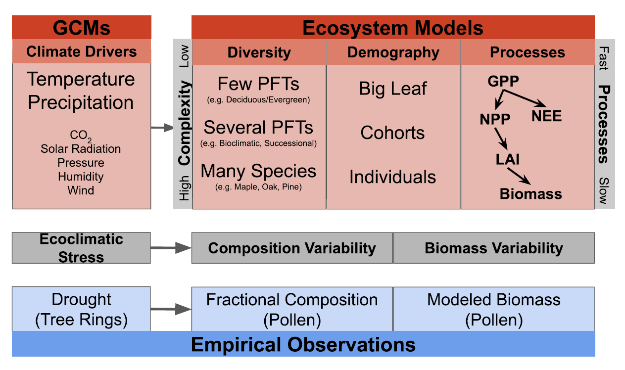
Figure 2. Overview of the unified conceptual framework (grey boxes) for parallel analysis of empirical data (blue boxes) and model output (red boxes) described in the study by Rollinson et al. (2021). For ecosystem models, the latent climatic and ecosystem processes are described for unobservable palaeoecological data and differences among models in complexity. Complexity is organized into three categories: 1) diversity, ranging from a few plant functional types (PFTs) to many species; 2) demography, ranging from "big leaf" models with no explicit treatment of forest demography to models with individual trees and 3) ecophysiological processes. Changes in forest biomass emerge from latent ecophysiological processes including gross primary productivity (GPP), net primary productivity (NPP), net ecosystem exchange (NEE), and leaf area index (LAI). Ecophysiological processes are controlled by the model representation of higher-level vegetation processes. Latent model drivers, processes, and states (red boxes) result in estimates of forest composition and biomass that can be compared to palaeoecological data products (blue boxes). Models vary in complexity due to design philosophy and trade-offs between model complexity and computational speed.
Data Access
These data are available through the Oak Ridge National Laboratory (ORNL) Distributed Active Archive Center (DAAC).
PalEON: Terrestrial Ecosystem Model Drivers for the Northeastern U.S., 0850-2010
Contact for Data Center Access Information:
- E-mail: uso@daac.ornl.gov
- Telephone: +1 (865) 241-3952
References
Braconnot, P., S. Harrison, M. Kageyama, P.J. Bartlein, V. Masson-Delmotte, A. Abe-Ouchi, B. Otto-Bliesner, and Y. Zhao. 2021. Evaluation of climate models using palaeoclimatic data. Nature Climate Change 2:417-424. https://doi.org/10.1038/nclimate1456
Jung, M., K. Henkel, M. Herold, and G. Churkina. 2006. Exploiting synergies of global land cover products for carbon cycle modeling. Remote Sensing of Environment, 101(4):534-553. https://doi.org/10.1016/j.rse.2006.01.020
Kumar, J., B.J. Brooks, P.E. Thornton, and M.C. Dietze. 2012. Sub-daily Statistical Downscaling of Meteorological Variables Using Neural Networks. Procedia Computer Science, 9:887-896. https://doi.org/10.1016/j.procs.2012.04.095
Poulter, B., N. MacBean, A. Hartley, I. Khlystova, O. Arino, R. Betts, S. Bontemps, M. Boettcher, C. Brockmann, P. Defourny, and S. Hagemann. 2015. Plant functional type classification for earth system models: Results from the European Space Agency's Land Cover Climate Change Initiative. Geoscientific Model Development, 8(7):2315-2328. https://doi.org/10.5194/gmd-8-2315-2015
Ramankutty, N., J.A. Foley, F.G. Hall, G.J. Collatz, B.W. Meeson, S.O. Los, E.Brown De Colstoun, and D.R. Landis. 2010. ISLSCP II Potential Natural Vegetation Cover. ORNL DAAC, Oak Ridge, Tennessee, USA. https://doi.org/10.3334/ORNLDAAC/961
Rollinson, C.R., A. Dawson, A. Raiho, J.W. Williams, M.C. Dietze, T. Hickler, S.T. Jackson, J. McLachlan, D.J.P. Moore, B. Poulter, T. Quaife, J. Steinkamp, and M. Trachsel. 2021. Forest responses to last-millennium hydroclimate variability are governed by spatial variations in ecosystem sensitivity. Ecology Letters, 24:498-508. https://doi.org/10.1111/ele.13667
Rollinson, C.R., Y. Liu, A. Raiho, D.J.P. Moore, J. McLachlan, D.A. Bishop, A. Dye, J.H. Matthes, A. Hessl, T. Hickler, N. Pederson, B. Poulter, T. Quaife, K. Schaefer, J. Steinkamp, and M.C. Dietze. 2017. Emergent climate and CO2 sensitivities of net primary productivity in ecosystem models do not agree with empirical data in temperate forests of eastern North America. Global Change Biology, 23(7):2755-2767. https://doi.org/10.1111/gcb.13626
Wei, Y., Shishi Liu, D.N. Huntzinger, A.M. Michalak, N. Viovy, W.M. Post, C.R. Schwalm, K. Schaefer, A.R. Jacobson, C. Lu, H. Tian, D.M. Ricciuto, R.B. Cook, J. Mao, and X. Shi. 2014. NACP MsTMIP: Global and North American Driver Data for Multi-Model Intercomparison. ORNL DAAC, Oak Ridge, Tennessee, USA. https://doi.org/10.3334/ORNLDAAC/1220