Documentation Revision Date: 2020-12-01
Dataset Version: 1
Summary
The processing steps required to derive these climate input variables at the desired temporal (3-hourly) resolution for the CLM model and the results of the CLM modeling across the western United States are described in the related publication (Buotte, et al., 2019). The temporal downscaling details are also provided in a companion file here. The modeled annual estimates of forest carbon stocks, fluxes and productivity are archived in the related dataset Buotte et al. (2019; https://doi.org/10.3334/ORNLDAAC/1662).
There are 1,332 data files in NetCDF (.nc4) format with this dataset. The files provide data for the years 1979 through 2015 and are organized by variable and month of each year.
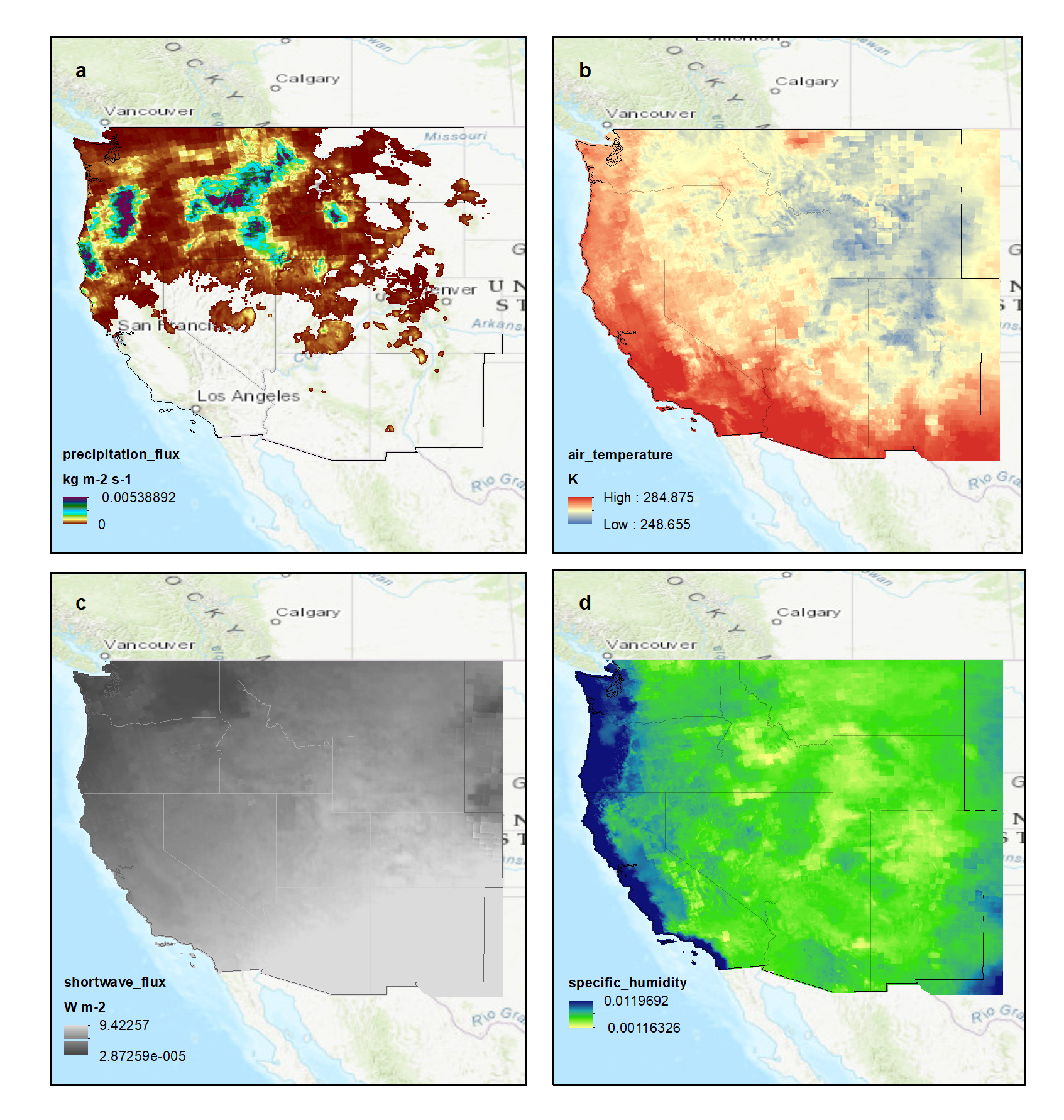
Figure 1. Four variables for the same 3-hour timestep, December 8, 2015, 12:00 AM to 3:00 AM, a) precipitation flux (kg m-2 s-1) b) air temperature (K) c) shortwave radiation flux (W m-2) d) specific humidity. Source: western_USA_precipitation_3hr_2015-12.nc4
Citation
Rupp, D., and P. Buotte. 2020. NACP: Climate Data Inputs (3-hourly) for Community Land Model, Western USA, 1979-2015. ORNL DAAC, Oak Ridge, Tennessee, USA. https://doi.org/10.3334/ORNLDAAC/1682
Table of Contents
- Dataset Overview
- Data Characteristics
- Application and Derivation
- Quality Assessment
- Data Acquisition, Materials, and Methods
- Data Access
- References
Dataset Overview
This dataset provides sub-daily, high-resolution, climate data inputs including temperature, precipitation, near-surface specific humidity, incoming short-wave radiation, and near-surface wind speed over 11 states of the western US, including Arizona, California, Colorado, Idaho, Montana, Nevada, New Mexico, Oregon, Utah, Washington, and Wyoming. The data were derived for use in the Community Land Model (CLM v4.5) and are at the CLM preferred temporal (3-hourly) and spatial (4 x 4 km) resolutions for the time period 1979 through 2015. The CLM was driven with observation-based and simulated gridded meteorological data at 1/24 degree. The source for observational data was METDATA and the source for the simulated data was MACAv2-METDATA, or MACA. Both METDATA and MACA are at a daily resolution and were disaggregated to a 3-hourly resolution. Modeling efforts using these data estimated annual carbon stocks, fluxes, and productivity across the western United States.
The processing steps required to derive these climate input variables from various sources at the desired temporal (3-hourly) and spatial resolutions for the CLM model, and the results of the CLM modeling across the western United States are described in a related publication (Buotte et al., 2019b). The modeled annual estimates of forest carbon stocks, fluxes, and productivity are archived in a related dataset (Buotte et al., 2019a).
Project: North American Carbon Program (NACP)
The North American Carbon Program (NACP) is a multidisciplinary research program to obtain scientific understanding of North America's carbon sources and sinks and of changes in carbon stocks needed to meet societal concerns and to provide tools for decision makers. The NACP is supported by a number of different federal agencies. The central objective is to measure and understand the sources and sinks of Carbon Dioxide (CO2), Methane (CH4), and Carbon Monoxide (CO) in North America and in adjacent ocean regions.
Related Publications
Buotte, P.C., S. Levis, B.E. Law, T.W. Hudiburg, D.E. Rupp, and J.J. Kent. 2019b. Near-future forest vulnerability to drought and fire varies across the western United States. Global Change Biology, 25:290-303. https://doi.org/10.1111/gcb.14490
Buotte, P.C., B.E. Law, W.J. Ripple, and L.T. Berner. 2020. Carbon sequestration and biodiversity co-benefits of preserving forests in the western United States. Ecological Applications, 30(2):e02039. https://doi.org/10.1002/eap.2039
Related Dataset
The data products provided in the current dataset were input data for processing and modeling for Buotte et al. 2019a.
Buotte, P., S. Levis, and B.E. Law. 2019a. NACP: Forest Carbon Stocks, Fluxes and Productivity Estimates, Western USA, 1979-2099. ORNL DAAC, Oak Ridge, Tennessee, USA. https://doi.org/10.3334/ORNLDAAC/1662
Acknowledgment
This work was supported by the North American Carbon Program (grant USDA-NIFA-2014-35100-22066).
Data Characteristics
Spatial Coverage: Western United States, including the states Arizona, California, Colorado, Idaho, Montana, Nevada, New Mexico, Oregon, Utah, Washington, and Wyoming
Spatial Resolution: ~4 km
Temporal Coverage: 1979-01-01 to 2016-01-01
Temporal Resolution: 3-hourly
Site Boundaries: Latitude and longitude are given in decimal degrees.
| Site | Westernmost Longitude | Easternmost Longitude | Northernmost Latitude | Southernmost Latitude |
|---|---|---|---|---|
| western United States | -124.813 | -101.979 | 49.0208 | 31.1875 |
Data File Information
There are 1,332 data files in NetCDF (*.nc4) format with this dataset. The files are named western_USA_variable_3hr_YYYY-MM.nc4, where
- variable = precipitation, solar_radiation, or wind_temp_humidity,
- YYYY = 1979 through 2015, and
- MM = 01 through 12
Table 1. File names and number of files.
| File Names | Number of Files |
|---|---|
| western_USA_precipitation_3hr_YYYY-MM.nc4 | 444 |
| western_USA_solar_radiation_3hr_YYYY-MM.nc4 | 444 |
| western_USA_wind_temp_humidity_3hr_YYYY-MM.nc4 | 444 |
Data File Details
For all files:
missing data: -9999
CRS: EPSG:4326, proj4:+proj=longlat +ellps=WGS84 +datum=WGS84 +no_defs.
Table 1. Variables in the data files. All data files include latitude, longitude, and time bounds.
| Variable | Abbreviation | Units | Description |
|---|---|---|---|
| precipitation | pr | kg m-2 s-1 | 3-hourly average precipitation flux |
| shortwave radiation | rsds | W m-2 | 3-hourly average surface downwelling shortwave radiation |
wind speed |
wind_speed | m s-1 | 3-hourly average wind speed near the surface |
| air temperature | tas | K | 3-hourly average air temperature |
| specific humidity | huss | dimensionless ratio | 3-hourly average near-surface specific humidity |
Companion Files
The companion file Climate_Data_Disaggregation_Methods_CompanionFile.pdf provides the methodology used to disaggregate the daily source data to the 3-hourly data provided in this dataset.
Application and Derivation
This data product contributes to a multidisciplinary research program to obtain scientific understanding of North America's carbon sources, carbon sinks, and changes in carbon stocks. These climate data and the disaggregation methods could be useful to other climate modeling studies.
Quality Assessment
Data bias correction is described in the companion file Climate_Data_Disaggregation_Methods_CompanionFile.pdf, and in Buotte et al. (2019b). Refer to the data sources in Section 5 of this document for quality assurance pertaining to the source data.
Data Acquisition, Materials, and Methods
Overview
This dataset provides the climate data inputs including temperature, precipitation, vapor pressure deficit, incoming short-wave radiation, and wind speed that were used in the modeling described in a related publication (Buotte et al., 2019b) to estimate annual carbon stocks, fluxes, and productivity across the western United States with the Community Land Model (CLM v4.5). These modeled estimates of forest carbon stocks, fluxes, and productivity are archived in a related dataset (Buotte et al., 2019a).
The processing required to derive these climate input variables at the desired spatial (4 x 4 km) and temporal (3-hourly) resolutions for the CLM model is the focus of this methods section. For details of the data disaggregation methods, refer to the companion file Climate_Data_Disaggregation_Methods_CompanionFile.pdf and to Buotte et al. (2019b).
Input Source Data
The Community Land Model (CLM) requires a time series of several meteorological variables as input. These variables include temperature, precipitation, vapor pressure deficit, incoming short-wave radiation, and wind speed. The desired temporal resolution of these variables is 3-hourly. Input data sources are listed in Table 2.
The CLM was driven with observation-based and simulated gridded meteorological data at a spatial resolution of 1/24 degree x 1/24 degree (~ 4 km). The source for observational data was METDATA and the source for the simulated data was MACAv2-METDATA (MACA hereon). Both METDATA and MACA are at a daily resolution, so the daily data were disaggregated to a 3-hourly resolution using the following methodology.
Disaggregation Process
When first initialized, CLM needs to run long enough for the above and belowground carbon pools to reach a steady state. To accomplish this, CLM was run for 1,500 model years with bias-corrected 1901–1929 CRUNCEP climate data by disaggregating daily 1/24 degree x 1/24-degree (4 km x 4 km) data (Abatzoglou, 2013). The 1979–2014 climate data served as the reference for the CRUNCEP data bias correction. Both METDATA and MACA are also at a daily resolution and were disaggregated to a 3-hourly resolution (Buotte et al., 2019b).
The 3-hourly NARR data were used to disaggregate the daily METDATA to a 3-hourly resolution. The 3-hourly data from the “raw” (i.e., not downscaled) CMIP5 GCM simulations were used to disaggregate the downscaled daily MACA to a 3-hourly resolution. Briefly, the method consists of "rescaling" the 3-hourly GCM (or NARR) time series to be consistent with aggregate daily values, or maximum and minimum daily values, from MACA (or METDATA). Note that the example of MACA 3-hour disaggregation is used, though the METDATA 3-hourly disaggregation follows the identical method, other than the GCM data are used with MACA whereas NARR is used with METDATA.
Table 2. Input data sources
| Observation-based gridded meteorological data (previously called METDATA, now called GRIDMET), daily, 1/24-degree resolution (Abatzoglou, 2013). Last accessed 2016-01-29. http://www.climatologylab.org/gridmet.html |
| North America Regional Reanalysis (NARR), three-hourly, 0.3-degree resolution (Mesinger et al., 2006). Accessed 2013-09-18 (data through 2012) and 2016-03-21 (data from 2013 through 2015). https://www.esrl.noaa.gov/psd/data/gridded/data.narr.html |
| Statistically downscaled global climate model simulations using the method of Multivariate Adaptive Constructed Analogs v.2 with METDATA as the training data (MACAv2-METDATA), daily, 1/24-degree resolution. Last accessed 2014-11-09. https://climate.northwestknowledge.net/MACA/ |
| Global climate model (GCM) output from the Coupled Model Intercomparison Project Phase 5 (CMIP5) archive, three-hourly, various spatial resolutions (Taylor et al., 2012). Our study uses output from IPSL-CM5A-MR r1i1p1 and MIROC5 r1i1p1, historical and rcp85 experiments. Last accessed 2011-11-05. https://esgf-node.llnl.gov/search/cmip5/ |
Data Access
These data are available through the Oak Ridge National Laboratory (ORNL) Distributed Active Archive Center (DAAC).
NACP: Climate Data Inputs (3-hourly) for Community Land Model, Western USA, 1979-2015
Contact for Data Center Access Information:
- E-mail: uso@daac.ornl.gov
- Telephone: +1 (865) 241-3952
References
Abatzoglou, J.T., 2013. Development of gridded surface meteorological data for ecological applications and modelling. International Journal of Climatology, 33:121-131. https://doi.org/10.1002/joc.3413
Buotte, P., S. Levis, and B.E. Law. 2019a. NACP: Forest Carbon Stocks, Fluxes and Productivity Estimates, Western USA, 1979-2099. ORNL DAAC, Oak Ridge, Tennessee, USA. https://doi.org/10.3334/ORNLDAAC/1662
Buotte, P.C., S. Levis, B.E. Law, T.W. Hudiburg, D.E. Rupp, and J.J. Kent. 2019b. Near-future forest vulnerability to drought and fire varies across the western United States. Global Change Biology, 25:290-303. https://doi.org/10.1111/gcb.14490
Buotte, P.C., B.E. Law, W.J. Ripple, and L.T. Berner. 2020. Carbon sequestration and biodiversity co-benefits of preserving forests in the western United States. Ecological Applications, 30(2):e02039. https://doi.org/10.1002/eap.2039
Mesinger, F., G. DiMego, E. Kalnay, K. Mitchell, P.C. Shafran, W. Ebisuzaki, et al. 2006. North American regional reanalysis. Bulletin of the American Meteorological Society, 87:343-360. https://doi.org/10.1175/BAMS-87-3-343
Mitchell, T.D., and P.D. Jones. 2005. An improved method of constructing a database of monthly climate observations and associated high-resolution grids. International Journal of Climatology, 25:693-712. https://doi.org/10.1002/joc.1181
Taylor, K.E., R.J. Stouffer, and G.A. Meehl. 2012. An overview of CMIP5 and the experiment design. Bulletin of the American Meteorological Society, 93:485-498. https://doi.org/10.1175/BAMS-D-11-00094.1