Get Data
Revision date: April 24, 2012
|
Please note that this version was superseded by Version 2 on 2013/03/01. Follow this link to the latest version: Masek, J.G., E.F. Vermote, N. Saleous, R. Wolfe, F.G. Hall, F. Huemmrich, F. Gao, J. Kutler, and T.K. Lim. 2013. LEDAPS Calibration, Reflectance, Atmospheric Correction Preprocessing Code, Version 2. ORNL DAAC, Oak Ridge, Tennessee, USA. http://dx.doi.org/10.3334/ORNLDAAC/1146 Contact ORNL DAAC User Services (uso@daac.ornl.gov) if you need additional assistance. |
Summary:
The Landsat Ecosystem Disturbance Adaptive Processing System (LEDAPS) is a NASA
project to map disturbance, regrowth, and permanent forest conversion across the continent
(Masek et al., 2006). The LEDAPS processes Landsat imagery to surface reflectance, using
atmospheric correction routines developed for the Terra MODIS instrument (Vermote et al., 1997).
The original LEDAPS software was developed at NASA GSFC by Eric Vermote, Nazmi Saleous, Jonathan
Kutler, and Robert Wolfe with support from the NASA Terrestrial Ecology program (PI: Jeff Masek).
This version was adapted by Dr. Feng Gao. It is a stand-alone version of Landsat 1T calibration,
TOA reflectance, cloud masking, and atmospheric correction preprocessing chain.
This version is designed to work with the standard “web enabled” EROS L1T product for Landsat-5 and Landsat-7.
The source code, installation and run instructions, and required ancillary data files are provided. Ancillary data for 1980 to 2010 are NCEP (National Centers for Environmental Prediction) water vapor data and TOMS (Total Ozone Mapping Spectrometer) ozone data. The 2011 ancillary data additions are also provided. To update your existing ancillary data, you only need to download recent updates. The ancillary data were updated and maintained on a monthly basis by the Hydrology and Remote Sensing Laboratory, USDA-ARS by Dr. Feng Gao.
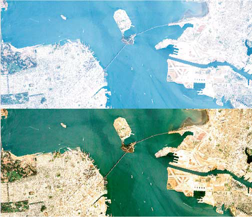
Example of LEDAPS atmospheric correction. (a) Top-of-atmosphere (TOA) reflectance composite (bands 3,2,1) for Landsat-7 ETM+ image of San Francisco Bay (July 7, 1999); (b) Surface reflectance composite. Both images are linearly scaled from p = 0.0 to 0.15. From Masek et al., 2006.
Data Citation:
Cite this LEDAPS code as follows:
Masek, J.G., E.F. Vermote, N. Saleous, R. Wolfe, F.G. Hall, F. Huemmrich, F. Gao, J. Kutler, and T.K. Lim. 2012. LEDAPS Landsat Calibration, Reflectance, Atmospheric Correction Preprocessing Code. ORNL DAAC, Oak Ridge, Tennessee, USA. http://dx.doi.org/10.3334/ORNLDAAC/1080
Model Product Description:
Source Code:
LedapsSrc_20111121.zip is a compressed file of the contents of LedapsSrc_20111121. The code is dated 11/21/2011.
Note that this file will extrapolated into bin, doc and src subdirectories and contains a readme.txt and release.note text files. The readme file contains the installation, run, and test instructions.
System Requirements:
The LEDAPS software runs on 32-bit or 64-bit Linux OS.
Input Data Sets:
These three files contain the required ancillary data files for running LEDAPS:
1. LedapsAnc_1980-2010.zip is a compressed file with the LedapsAnc_1980-2010 - data for 1980 through 2010.
It contains 2 zip files and a digital elevation model data file within it described as follows:
a. EP_TOMS.zip contains ozone_YYYY.zip where YYYY is 1981 through 2010.
- Each zip file contains 365 or 366 TOMS_YYYYDDD.hdf files where YYYY = year and DDD = day of the year.
- These files are in hdf format.
b. CMGDEM.hdf - a digital elevation model data file
c. REANALYSIS.zip - contains RE_YYYY.zip - where YYYY is a year 1980 through 2010.
- Each of these zips contains REANALYSIS_YYYYDDD.hdf files where YYYY is the year 1980-2010 and DDD is the day of the year.
- These files are in hdf format.
2. LedapsAnc_2011.zip is a compressed file with LedapsAnc_2011 and Reprocessed 2011 data .
It contains two zip files within it described as follows:
a. EP_TOMS.zip contains TOMS_2011DDD.hdf files.
- The zip file contains 365 TOMS_YYYYDDD.hdf files where YYYY = year and DDD = day of the year.
- These files are in hdf format.
REANALYSIS.zip - REANALYSIS_2011DDD.hdf reprocessed files
- The zip file contains 365 REANALYSIS_YYYYDDD.hdf files where YYYY = year and DDD = day of the year.
- These files are in hdf format.
3. LedapsAnc_2012.zip is a compressed file with LedapsAnc_2012 and Reprocessed 2012 data. Note: January 2012 only.
a. EP_TOMS.zip - TOMS_2012DDD.hdf - where DDD is 1 to 30 - reprocessed 2012 - only 30 files in hdf format.
b. REANALYSIS.zip - REANALYSIS_2012DDD, where DDD is 1 to 30 - reprocessed 2012 - only 30 files in hdf format.
LEDAPS Command-line Applications:
LEDAPS consists of four command-line applications, intended to be run in sequence:
- lndpm: extracts metadata from the standard Landsat product, and writes configuration files for the rest of the processing chain. Also outputs ENVI header files.
- lndcal: calibrates Landsat-5 TM and Landsat-7 ETM+ data, and generates top-of-atmosphere reflectance. Also writes TOA brightness temperature file for band 6.
- lndcsm: generates cloud mask using the ACCA (Automated Cloud Cover Assessment) algorithm (Irish et al., 2006).
- lndsr: performs atmospheric correction for the Landsat reflective bands using the Vermote et al. (1997) MODIS/6S radiative transfer approach, with aerosols obtained from the image itself using the Kaufmann et al (1997) "dark dense vegetation" methodology.
Model Output:
Output files for each Landsat image processed include:
- lndcal.*.hdf: top-of-atmosphere (TOA) reflectance in HDF format
- lndth.*.hdf: themal brightness temperature in HDF format
- lndcsm.*.hdf: cloud mask from ACCA algorithm
- lndsr.*.hdf: surface reflectance in HDF format
Each file is also associated with an ENVI header file that contains geographic information.
Data Access:
This data is available through the Oak Ridge National Laboratory (ORNL) Distributed Active Archive Center (DAAC).
Data Archive Center:
Contact for Data Center Access Information:
E-mail: uso@daac.ornl.gov
Telephone: +1 (865) 241-3952
References:
Irish, R., Barker, J., Goward, S., and Arvidson, T., 2006, Characterization of the Landsat-7 ETM+ Automated Cloud Cover Assessment (ACCA) Algorithm, Photogrammetric Engineering & Remote Sensing, 72, 1179-1188.
Kaufman, Y., et al., 1997, The MODIS 2.2 micron channel ? Correlation with visible reflectance for use in remote sensing of aerosol, IEEE Trans. Geosci. Remote Sens., 35, 1286-1298.
Masek, J.G., E.F. Vermote, N. Saleous, R. Wolfe, F.G. Hall, F. Huemmrich, F. Gao, J. Kutler, and T.K. Lim, A Landsat surface reflectance data set for North America, 1990-2000, Geoscience and Remote Sensing Letters, 3, 68-72, 2006.
Vermote, E.F. et al., 1997, Atmospheric correction of visible to middle-infrared EOS-MODIS data over land surfaces: Background, operational algorithm, and validation, J. Geophys. Res., 102, 17131-17141.