Documentation Revision Date: 2024-02-01
Dataset Version: 1.0
Summary
The MASTER instrument is a modified Daedalus Wildfire scanning spectrometer that flies on a variety of multi-altitude research aircraft and provides spectral information similar to that provided by the Moderate Resolution Imaging Spectroradiometer (MODIS) and the Advanced Spaceborne Thermal Emission and Reflection Radiometer (ASTER), which are aboard two NASA Earth Observing System satellites: Terra and Aqua.
NASA facility instruments operate out of a NASA research center and support multiple science disciplines, field investigations, and NASA science objectives. Facility instruments are supported by managers in the Earth Science Division (ESD) Research and Analysis Program, and/or the Earth Observation System (EOS) Project Science Office.
This dataset includes a total of 29 files: a table in comma-separated values (CSV) format, a shapefile in compressed (.zip) format, a GeoJSON file, and 26 files in compressed Keyhole Markup Language (.kmz).
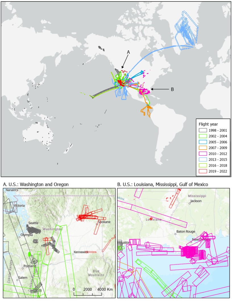
Figure 1. Distribution of MASTER flight lines over Greenland, North America, and Pacific Ocean for 1998 to 2022. Insets show details of flights in the U.S. over (A) Washington and Oregon and (B) Louisiana, Mississippi, and Gulf of Mexico. Footprints of acquired imagery are shown as rectangular polygons.
Citation
Hook, S.J., E.W. Fraim, R.O. Green, J.S. Myers, K.J. Thome, M. Fitzgerald, A.B. Kahle, and Airborne Sensor Facility NASA Ames Research Center. 2023. MASTER: Flight Line Geospatial Polygons and Contextual Data. ORNL DAAC, Oak Ridge, Tennessee, USA. https://doi.org/10.3334/ORNLDAAC/2151
Table of Contents
- Dataset Overview
- Data Characteristics
- Application and Derivation
- Quality Assessment
- Data Acquisition, Materials, and Methods
- Data Access
- References
- Dataset Revisions
Dataset Overview
This dataset provides resources for identifying flight lines of interest for the MODIS/ASTER Airborne Simulator (MASTER) instrument based on spatial and temporal criteria. MASTER first flew in 1998 and has ongoing deployments as a Facility Instrument in the NASA Airborne Science Program (ASP). MASTER is a joint project involving the Airborne Sensor Facility (ASF) at the Ames Research Center, the Jet Propulsion Laboratory (JPL), and the Earth Resources Observation and Science Center (EROS). The primary goal of these airborne campaigns is to demonstrate important science and applications research that is uniquely enabled by the full suite of MASTER thermal infrared bands as well as the contiguous spectroscopic measurements of the AVIRIS (also flown in similar campaigns), or combinations of measurements from both instruments. This dataset includes a table of flight lines with dates, bounding coordinates, site names, investigators involved, flight attributes, and associated campaigns for the MASTER Facility Instrument Collection. A shapefile containing flights for all years, a GeoJSON version of the shapefile, and separate KMZ files for each year allow users to visualize flight line locations using GIS software.
The MASTER instrument is a modified Daedalus Wildfire scanning spectrometer that flies on a variety of multi-altitude research aircraft and provides spectral information similar to that provided by the Moderate Resolution Imaging Spectroradiometer (MODIS) and the Advanced Spaceborne Thermal Emission and Reflection Radiometer (ASTER), which are aboard two NASA Earth Observing System satellites: Terra and Aqua.
NASA facility instruments operate out of a NASA research center and support multiple science disciplines, field investigations, and NASA science objectives. Facility instruments are supported by managers in the Earth Science Division (ESD) Research and Analysis Program, and/or the Earth Observation System (EOS) Project Science Office.
Related Publication
Hook, S.J. Myers, J.J., Thome, K.J., Fitzgerald, M. and A.B. Kahle. 2001. The MODIS/ASTER airborne simulator (MASTER) - a new instrument for earth science studies. Remote Sensing of Environment 76:93–102. https://doi.org/10.1016/S0034-4257(00)00195-4
Related Datasets
Additional MASTER data products are available on the ORNL DAAC MASTER project page.
Acknowledgments
The MASTER instrument is maintained and operated by the Airborne Sensor Facility (ASF) at NASA Ames Research Center in Mountain View, California, under the oversight of the EOS Project Science Office at NASA Goddard. Data processing was conducted at NASA Ames Research Center and the Jet Propulsion Laboratory at the California Institute of Technology in Pasadena, California.
Data Characteristics
Spatial Coverage: North America, Europe, and southern Asia
Spatial Resolution: 5 to 50 m
Temporal Coverage: 1998-12-02 to 2023-05-02
Temporal Resolution: One-time estimate: start and stop time of each flight line to nearest second.
Study Areas: All latitudes and longitudes given in decimal degrees.
| Site | Westernmost Longitude | Easternmost Longitude | Northernmost Latitude | Southernmost Latitude |
|---|---|---|---|---|
| North America, Greenland, Hawaii, Pacific Rim, Central America | -171.99 | 179.47 | 78.679 | -55.380 |
Data File Information
This dataset includes a total of 29 files: a table in comma-separated values (CSV) format, a shapefile in compressed (.zip) format, a GeoJSON, and 25 files in compressed Keyhole Markup Language (.kmz).
MASTER_flights_table.csv holds information for each flight line in tabular form (Table 1).
MASTER_flights_shapefile.zip holds a shapefile of imagery footprints for each flight line. The footprints are rectangular polygons with attributes listed in Table 1.
MASTER_flights.geojson provides imagery footprints for each flight line in GeoJSON format. The footprints are rectangular polygons with attributes listed in Table 1.
MASTER_YYYY.kmz are 26 maps of imagery footprints, one for each year (YYYY) 1998 to 2023, in compressed Keyhole Markup Language. These footprint polygons have attributes with non-missing values.
Table 1. Variables in the MASTER_flights_table.csv, MASTER_flights_shapefile.zip, and MASTER_YYYY.kmz
| Variable name in | Units | Description | |
|---|---|---|---|
| CSV | shapefile, GeoJSON and KMZ's | ||
| year | year | YYYY | Year of flight. |
| date | date | YYYY-MM-DD | Date of flight. |
| flight_ID | flt_ID | - | Flight identifier in the format of 7 digits. A "flight" occurs on a single day and includes multiple segments (or "tracks"). |
| flight_line | flt_line | - | Unique identifier of each flight line that includes the flight_ID + flight_track, separated by an underscore (e.g., "2262800_10"). |
| flight_track | flt_track | - | Portion of the flight_line ID that denotes a segment of of the flight with two digits. |
| L1B_name | L1B_file | - | Name of associated Level 1B (L1B) radiance data file in HDF-4 format available from ORNL DAAC. |
| L2_name | L2_file | - | Beginning portion of filename for associated Level 2 (L2) data files available from ORNL DAAC. There are multiple files available for flight lines having L2 data, which include emissivity and surface temperature. |
| site_name | site_name | - | Site information derived from ancillary files. |
| investigator | investgtr | - | Investigator names from ancillary files. |
| start_lat | start_lat | degrees_north | Starting latitude of flight line of aircraft from ancillary files. |
| start_lon | start_lon | degrees_east | Starting longitude of flight line of aircraft from ancillary files. |
| stop_lat | stop_lat | degrees_north | Ending latitude of flight line of aircraft from ancillary files. |
| stop_lon | stop_lon | degrees_east | Ending longitude of flight line of aircraft from ancillary files. |
| start_GMT | start_gmt | YYYY-MM-DD hh:mm:ss | Starting time of flight line of aircraft in GMT. |
| stop_GMT | stop_gmt | YYYY-MM-DD hh:mm:ss | Ending time of flight line of aircraft in GMT. |
| comments | comments | - | Comment text from ancillary files. |
| campaign | campaign | - | Name of campaign from ancillary files. |
| flight_purpose | purpose | - | Additional information related to campaign or deployment. |
| state | state | - | Name of U.S. state derived by overlaying bounding polygon on map of US states. |
| country | country | - | Name of country derived by overlaying bounding polygon on maps of world countries and 12-NM maritime boundaries. Blank if over open ocean. |
| platform | platform | - | The airborne platform. |
| instrument | instrument | - | "MASTER" |
| altitude | altitude | m | Aircraft altitude above mean sea level (m a.s.l.). |
| speed_on_ground | speed_grnd | m s-1 | Ground speed of aircraft computed from distance and time. |
| direction | direction | degrees | Aircraft heading. |
| weather_condition | weather | - | Comments on weather conditions during flight. |
| gp_lon1 | - | degree_east | Longitude coordinates for points of bounding rectangle of acquired imagery. |
| gp_lon2 | - | ||
| gp_lon3 | - | ||
| gp_lon4 | - | ||
| gp_lat1 | - | degree_north | Latitude coordinates for points of bounding rectangle of acquired imagery. |
| gp_lat2 | - | ||
| gp_lat3 | - | ||
| gp_lat4 | - | ||
| L1_lnk | L1_lnk | - | URLs for downloading L1B radiance file from DAAC archive; blank if no file available. |
| L2_emiss_lnk | L2_em_lnk | - | URLs for downloading L2 emissivity file from DAAC archive; blank if no file available. |
| L2_surfacetemp_lnk | L2_st_lnk | - | URLs for downloading L2 surface temperature file from DAAC archive; blank if no file available. |
All geographic coordinates use the WGS 1984 datum: EPSG 4326.
The nodata value for numeric fields is -999 and "NA" for text fields.
User Note: An active Earthdata login session is required to download files using these URLs. New users may register for an Earthdata login account at http://urs.earthdata.nasa.gov/.
Application and Derivation
These resources allow the user to identify MASTER flights that meet desired spatiotemporal criteria. The shapefile and KMZ files, along with GIS software, can be used to visualize the geographic distributions of flights and filter them based on associated attributes.
Once candidate flights are identified, use the date (e.g, date or start_GMT fields) along with the keyword "MASTER" , Project == "MASTER", to find and download related granules using Earthdata Search.
About MASTER
The MASTER instrument is a modified Daedalus Wildfire scanning spectrometer that flies on a variety of multi-altitude research aircraft and provides spectral information similar to that provided by the Moderate Resolution Imaging Spectroradiometer (MODIS) and the Advanced Spaceborne Thermal Emission and Reflection Radiometer (ASTER), which are aboard two NASA Earth Observing System satellites: Terra and Aqua. Data products include Level 1B (L1B) georeferenced multispectral imagery of calibrated radiance in 50 bands covering wavelengths of 0.460 to 12.879 micrometers. Derived Level 2 (L2) data products include emissivity in 5 bands in thermal infrared range (8.58 to 12.13 micrometers) and land surface temperature. L1B data are available for each flight, but L2 products are not available for all flight lines.
The primary objective of MASTER is to: (a) collect ASTER-like and MODIS-like land datasets to support the validation of the ASTER and MODIS geophysical retrieval algorithms; (b) collect these datasets at a higher resolution than the spaceborne datasets to permit scaling studies and comparisons with in-situ measurements; and (c) under fly the EOS-AM1 ASTER and MODIS sensors to provide an additional radiometric calibration to assist with in-flight instrument performance characterization. Calibration is particularly important for ASTER where on-board calibration is dependent on a single black body in the TIR and only partial aperture illumination in the VNIR.
A secondary objective of MASTER is to: (a) provide both a backup instrument and backup modules for the current MODIS Airborne simulator, which is committed to a program of atmospheric and oceanic measurements; and (b) provide a wider spectral and dynamic range alternative to the use of the Thematic Mapper (TM) airborne simulator and Thermal Infrared Multispectral Scanner (TIMS) airborne scanners (JPL, 2021).
The MASTER instrument has been deployed on a variety of airborne platforms ranging from a single engine propeller-driven Cessna to NASA's high altitude ER-2 jet. Spatial resolution of acquired imagery varies between 2 to 50 m and depends on aircraft altitude, or more specifically, the distance between instrument and earth's surface. Additional sensors, including PICARD, AVIRIS, and HyTES, were often deployed on the same flights with MASTER.
MASTER products can identify vegetation type and health and provide a benchmark for the state of the ecosystems against which future changes can be assessed.. MASTER imagery has been used for mapping wildfires and their impacts (Veraverbeke et al., 2011), land cover (Li and Moon, 2004), coral reefs (Capolsini et al., 2003), and urban heat islands (Zhao and Wentz, 2016).
Access to MASTER data products is available from the ORNL DAAC MASTER project page or Earthdata Search.
Quality Assessment
Flight dates, times, and bounding coordinates were validated with data in acquired L1B files.
Data Acquisition, Materials, and Methods
Flight line information was derived from L1B data files and ancillary files for campaigns and deployments provided by the MASTER program at NASA's Airborne Sensor Facility at Ames Research Center (https://asapdata.arc.nasa.gov/sensors/master/campaigns.html).
Fields on flight altitude, direction, and weather were parsed from comment text included with the ancillary files. The speed_on_ground value was computed by measuring distance traveled using aircraft positions (start_lat, start_lon, stop_lat, stop_lon) over time elapsed (start_GMT, stop_GMT).
The country and state fields were determined by overlaying the bounding rectangles on maps of U.S. states (U.S. Census Bureau, 2022), world countries (https://data.worldbank.org/), and country maritime boundaries (12-nautical mile boundary; Flanders Marine Institute, 2019). If the country field is empty, the bounding rectangle was over open ocean. The state field is filled only for flights over land in the U.S.
Data Access
These data are available through the Oak Ridge National Laboratory (ORNL) Distributed Active Archive Center (DAAC).
MASTER: Flight Line Geospatial Polygons and Contextual Data
Contact for Data Center Access Information:
- E-mail: uso@daac.ornl.gov
- Telephone: +1 (865) 241-3952
References
ASF. 2022. MASTER campaigns and deployments. Airborne Sensor Facility, NASA Ames Research Center, Airborne Science Program; Moffett Field, California. https://asapdata.arc.nasa.gov/sensors/master/campaigns.html
Hook, S.J. Myers, J.J., Thome, K.J., Fitzgerald, M. and A.B. Kahle. 2001. The MODIS/ASTER airborne simulator (MASTER) - a new instrument for earth science studies. Remote Sensing of Environment 76:93–102. https://doi.org/10.1016/S0034-4257(00)00195-4
Flanders Marine Institute. 2019. Maritime Boundaries Geodatabase: Territorial Seas (12NM), version 3. https://www.marineregions.org. https://doi.org/10.14284/387.
JPL. 2021. Science objectives, MASTER: MODIS/ASTER Airborne Simulator. Jet Propulsion Laboratory, California Institute of Technology, Pasadena, California, USA. https://masterprojects.jpl.nasa.gov/objectives
Li, P., and W.M. Moon. 2004. Land cover classification using MODIS-ASTER airborne simulator (MASTER) data and NDVI: A case study of the Kochang area, Korea. Canadian J. Remote Sensing 30:123-126. https://doi.org/10.5589/m03-061
U.S. Census Bureau. 2022. TIGER/Line and TIGER-related products electronic resource: TIGER, Topologically Integrated Geographic Encoding and Referencing system. https://www.census.gov/geographies/mapping-files/time-series/geo/tiger-line-file.html
Veraverbeke, S., S. Harris, and S. Hook. 2011. Evaluating spectral indices for burned area discrimination using MODIS/ASTER (MASTER) airborne simulator data. Remote Sensing of Environment 115:2702-2709. https://doi.org/10.1016/j.rse.2011.06.010
Zhao, Q., and E.A. Wentz. 2016. A MODIS/ASTER Airborne Simulator (MASTER) imagery for urban heat island research. Data 1:7. https://doi.org/10.3390/data1010007
Dataset Revisions
| Version | Release Date | Revision Notes |
|---|---|---|
| 1.0 | 2024-02-01 | Added information for Spring 2023 flights, fields holding download URLs for data files, and a GeoJSON version of imagery footprints. |
| 1.0 | 2023-03-15 | First publication |