Get Data
Summary
This data set contains hydrology, soils, radiation, cloud, and vegetation data from the International Satellite Land Surface Climatology Project (ISLSCP) Initiative I. The ISLSCP data sets should provide LBA modelers with many of the fields required to describe boundary conditions, and to initialize and force a wide range of land-biosphere-atmosphere models. All of the data have been processed to the same global spatial resolution (1 deg. x 1 deg.), using the same land/sea mask and steps have been taken to ensure spatial and temporal continuity of the data. The data sets cover the period 1987-1988 at 1-month time resolution for most of the seasonally varying quantities. For this pre-LBA data set, the ISLSCP I data are provided as global coverages. The companion file illustrations were subset over the LBA study area, from 35-85 deg. W longitude and 20 deg. S to 10 deg. N latitude, as shown in Figure 1.
The data files and illustrations are organized into the three groups listed below.
- Hydrology and Soils
- Radiation and Clouds
- Vegetation
The data within each of these areas were acquired from a variety of sources including model output, satellites, and ground measurements. The individual data sets were provided in a variety of forms. In some cases, this required the data publication team to regrid and reformat data sets and in others to produce monthly averages from finer resolution data. The specific processing for each data set is detailed in the documentation.
The processed, quality controlled and integrated data in the documented Pre-LBA Data sets were originally published as a set of three CD-ROMs (Marengo and Victoria, 1998) but are now archived individually.
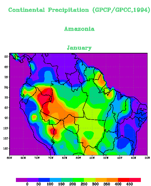
Figure 1. Typical illustration of ISLSCP monthly-averaged data showing the Amazon geographic region
Pre-LBA Data Set Collection Initiative
The Pre-LBA data set collection was dedicated to providing information to the LBA research community about existing data that have been collected in Amazonia during the 20 years prior to 1998. The main goal of this activity was to compile and document existing data sets in a consistent manner and make them available prior to the beginning of the LBA experiment.
The data set compilation efforts included satellite illustrationry, micrometeorological observations, near surface and upper-air atmospheric conditions, surface biophysical and hydrological measurements obtained from 1970s-1990s in a number of field experiments. Data were collected for several intensive field campaigns, during the rainy and dry seasons, and other periods that vary from short intensive field campaigns to several years worth of observations, measured sometimes with a time resolution of 5 minutes and 1 hour.
Citation:
Cite this data set as follows:
Sellers, P. J. 2009. Pre-LBA ISLSCP Initiative I Data. Data set. Available on-line [http://daac.ornl.gov] from Oak Ridge National Laboratory Distributed Active Archive Center, Oak Ridge, Tennessee, U.S.A. doi:10.3334/ORNLDAAC/919
The original CD-ROM citation is as follows:
Marengo, J.A., and R.L. Victoria. 1998. Pre-LBA Data Sets Initiative, 3 vols. [Pre-Large-Scale Biosphere-Atmosphere Experiment in Amazonia Data Sets Initiative, 3 vols.]. CD-ROM. Centro de Previsao de Tempo e Estudios Climaticos, Instituto Nacional de Pesquisas Espaciais (CPTEC/INPE) [Center for Weather Forecasting and Climate Study, National Institute for Space Research], Sao Paulo, Brazil.
Pre-LBA Data Set Collection Metadata Project: ERBE > Earth Radiation Budget Experiment Project: ISCCP > International Satellite Cloud Climatology Project Project: ISLSCP INITIATIVE-I > International Satellite Land Surface Climatology Project Initiative-I Originating_Center: GSFC_DAAC Science_Review_Date: 1995-05-15 | |
| Keywords
SBIOSPHERE CLOUD AMOUNT CLOUD OPTICAL THICKNESS CLOUD TOP PRESSURE CLOUD WATER PATH CRYOSPHERE FEATURES DEW POINT TEMPERATURE DRAINAGE BASINS ECMWF FAPAR FASIR NDVI FPAR GCM GEWEX GLACIER ICE GPCP GREENNESS GRID DATA HOURLY DATA IDN_NODE GSFC/GSFC_DAAC ISCCP LAND COVER LATENT HEAT FLUX LEAF AREA INDEX LONGWAVE RADIATION FLUX MARSH MODEL OUTPUT MONTHLY DATA NDVI NET RADIATION FLUX NMC RIVER FLOW SALT FLATS SALT MARSH SALTWATER SAND DUNES SEA ICE CONCENTRATION SEA SURFACE TEMPERATURE SENSIBLE HEAT FLUX SHORTWAVE RADIATION FLUX SNOW COVER SNOW DEPTH SOIL DEPTH SOIL SLOPE SOIL TEMPERATURE SOIL TEXTURE SURFACE BACKGROUND REFLECTANCE SURFACE PAR SURFACE ROUGHNESS LENGTH SURFACE RUNOFF SURFACE SOIL MOISTURE SWAMP UNFAO VEGETATION VEGETATION CLASSIFICATION MAP WIND SPEED WIND STRESS |
Temporal_Coverage Start_Date: 1987-01-01 Stop_Date: 1988-12-31 Spatial_Coverage Southernmost_Latitude: 90S Northernmost_Latitude: 90N Westernmost_Longitude: 180W Easternmost_Longitude: 180E Location: GLOBAL Investigator First_Name: PIERS Middle_Name: J. Last_Name: SELLERS Address NASA Goddard Space Flight Center Greenbelt MD 20771 USA Technical_Contact First_Name: JAMES Middle_Name: M. Last_Name: MCMANUS Address NASA Goddard Space Flight Center Greenbelt MD 20771 USA |
Data Description
All of the data have been processed to the same global spatial resolution (1 deg. x 1 deg.), using the same land/sea mask and steps have been taken to ensure spatial and temporal continuity of the data. The data sets cover the period 1987-1988 at 1-month time resolution for most of the seasonally varying quantities.
Data Files
- The data files are organized by the three types listed below: Hydrology and Soils Radiation and Clouds, and Vegetation. Data files for a given type have been compiled and compressed into *.zip files as shown in the table.
- Please note that while the data grids are all in the same format (see below) the "no data" value may vary. Fill or missing values are given in the respective data file's readme file (Section 8, Data Description).
Docummentation Files
The data within each of these areas were acquired from a variety of sources including model output, satellites, and ground measurements. The individual data sets were provided in a variety of forms. In some cases, this required the data publication team to regrid and reformat data sets and in others to produce monthly averages from finer resolution data.
- The specific handling for each data type is detailed in the documentation files that are included as companion files with this data set. These documentation files are linked in the table below.
- Please note that the Readme Files contain references to data file locations on the original distribution CDs and contact information that are no longer applicable. Data file naming syntax descriptions are applicable.
Illustration Files
Each data file has a corresponding .gif illustration file. Figure 1 is a typical representation of the ISLSCP data over the 35-85 deg. W longitude and 20 deg. S to 10 deg. N latitude Amazon geographic region.
- The illustration files are similarly organized by the three types listed below: Hydrology and Soils, Radiation and Clouds, and Vegetation. All of the illustration files for a given type have been compiled and compressed into *.zip files as shown in the table.
|
ISLSCP I Data Type ( data files ) |
Data Description and Links to Companion Files with Details of ISLSCP I Processing, Data File Formats, and Example illustration Files |
|---|---|
| Hydrology and Soils (HYDR_SOL.zip) |
Precipitation (Monthly; GPCP/GPCC) Hydrology cover fractions(Fixed; Trent University) Global soil properties(Fixed; FAO, GISS, U. Arizona, NASA/GSFC) Readme files: http://daac.ornl.gov/daacdata/lba/land_use_land_cover_change/ISLSCP/comp/Hydrology_and_Soils_Readme.zip illustration files: http://daac.ornl.gov/daacdata/lba/land_use_land_cover_change/ISLSCP/comp/HYDR_SOL.zip |
| Radiation and Clouds (RADIATN_CLOUDS.zip) (RADIATN_ERBE_ALB.zip) (RADIATN_MTH_3HR.zip) (RADIATN_MTH_MEAN.zip) |
Monthly cloud products (C2) (Monthly; ISCCP/GISS)
ERBE S4 Clear-Sky Albed . (Monthly Mean Albedo; NASA/LaRC) Surface and Top of Atmosphere (TOA) Shortwave and Photosynthetically Active Radiation (PAR) Fluxes (Monthly 3-Hourly Fluxes ; UMD/Dept. Meteorology)
Surface Shortwave and Longwave Radiation Fluxes (Monthly Mean Fluxes; NASA/LaRC)
Readme files: http://daac.ornl.gov/daacdata/lba/land_use_land_cover_change/ISLSCP/comp/Radiation_and_Clouds_Readme.zip illustration files: http://daac.ornl.gov/daacdata/lba/land_use_land_cover_change/ISLSCP/comp/RADIATN.zip |
Vegetation (VEGETATN.zip) |
Background (soil/litter layer) reflectance
(Fixed; CSU, NASA/GSFC) Fraction of photosynthetic active radiation absorbed by the green vegetation canopy (FPAR) (Monthly; NASA/GSFC) Percentage green leaf area of total leaf area (Greenness) (Monthly; NASA/GSFC) Total Leaf Area Index (LAI) (Monthly; NASA/GSFC) Normalized difference vegetation index (NDVI) (Monthly; NASA/GSFC) Roughness length (Zo) (Monthly; NASA/GSFC) Calculated snow-free albedo (Monthly; CSU, NASA/GSFC) Global land cover classification from satellite data (Fixed; UMD, NASA/GSFC) Readme files: http://daac.ornl.gov/daacdata/lba/land_use_land_cover_change/ISLSCP/comp/Vegetation_Readme.zip illustration files: http://daac.ornl.gov/daacdata/lba/land_use_land_cover_change/ISLSCP/comp/VEGETATN.zip |
Data File Format
|
Data Format. The file format is ASCII, and consists of numerical fields of varying length, which are space delimited and arranged in columns and rows. Each column contains 180 numerical values and each row contain 360 numerical values. < Grid arrangement ARRAY(I,J) I = 1 IS CENTERED AT 179.5W79.5W79.5W79.5W I INCREASES EASTWARD BY 1 DEGREE J = 1 IS CENTERED AT 89.5N J INCREASES SOUTHWARD BY 1 DEGREE
90N - | - - - | - - - | - - - | - - | (1,1) | (2,1) | (3,1) | 89N - | - - - | - - - | - - - | - - | (1,2) | (2,2) | (3,2) | 88N - | - - - | - - - | - - - | - - | (1,3) | (2,3) | (3,3) | 87N - | - - - | - - - | - - - | 180W 179W 178W 177W
ARRAY(360,180)
|
References
Dorman, J.L. and P.J. Sellers, 1989. A global climatology of albedo, roughness length and stomatal resistance for atmospheric general circulation models as represented by the simple biosphere model (SiB). J.A.M., 28(9):833-855.
Meeson, B.W., F.E. Corprew, J.M.P. McManus, D.M. Myers, J.W. Closs, K.-J. Sun, D.J. Sunday, P.J. Sellers. 1995. ISLSCP Initiative I -- Global Data Sets for Land-Atmosphere Models,1987-1988. Volumes 1-5. Published on CD by NASA (USA_NASA_GDAAC_ISLSCP_001 - USA_NASA_GDAAC_ISLSCP_005).
Satellite/Instrument/Data Processing Documentation
Brankovic, C., and J. Van Maanen, 1985. The ECMWF Climate system. ECMWF Rech. Memo. No 109 51 pp + figs.
ECMWF Manual 3: ECMWF forecast model physical parametrization, 3rd Edition.
ECMWF Research Department, Shinfield Park, Reading, Berkshire RGE 9AX, England.
CMWF, The Description of the ECMWF/WCRP Level III-A Global Atmospheric Data Archive. ECMWF Operations Department Shinfield Park, Reading, Berkshire RGE 9AX, England.
Journal Articles and Study Reports
Alexander, R. C. and R. L. Mobley, 1974. Monthly average sea-surface temperatures and ice-pack limits for 1 degree global grid. RAND Rep. R01310-ARPA, 30 pp.
Baumgartner, A., H. Mayer and W. Metz, 1977. Weltweite Verteilung des Rauhigkeitsparameters z(o) mit Anwendung auf die Energiedissipation and der Erdoberflache. Meteor. Rundschau., 30:43-48.
Betts, A.K., J.H. Ball, and A.C.M. Beljaars, 1993.Comparison between the land surface response of the ECMWF model and the FIFE-1987 data. Q.J.R. Meteorol. Soc., 119:975-1001.
Dewey, K. F. and R. Heim, Jr., 1982. Variations in Northern Hemisphere snow cover utilizing digitized weekly charts from satellite illustrationry, 1967-1980. Proceedings of the 6th Annual Climate Diagnostics Workshop, Palisades, N.Y., 157-165.
Elsaser, W. M., 1942. Heat transfer by infrared radiation in the atmosphere. Harvard Meteorological Studies No. 6, 107 pp.
Fouqart, Y., and B. Bonnel, 1980. Computations of solar heating of the earth's atmosphere: a new parameterization. Beitr. Phys. Atmos., 53:35-62
Geleyn, J. F., A. Hollingsworth, 1979. An economical analytical method for the computation of the interaction between scattering and line absorption of radiation. Beitr. Phys. Atmos., 52:1-16.
Geleyn, J. F. and H. J. Preuss, 1983. A new data set of satellite- derived surface albedo values for operational use at ECMWF. Arch. Meteor. Geophys. Bioclim., Ser. A, 32:353-359.
Janssen, P. A. E. M., A. C. M. Beljaar, A. Simmons, and P. Viterbo, 1992. The determination of the surface stress in an atmospheric model. Mon. Wea. Rev., 120:2977-2985.
Jarraud, M., A. J. Simmons, and M. Kanamitsu, 1988. Sensitivity of medium-range weather forecast to the use of an envelope orography. Q. J. Royal Meteorol. Soc., 114:989-1025.
Louis, J. F., 1979. A parametric model of vertical eddy fluxes in the atmosphere. Boundary Layer Meteorol., 17:187-202.
Miller, M. J., T. N. Palmer, and R. Swinbank, 1989. Parametrization and influence of subgridscale orography in general circulation and numerical weather prediction models. Meteorol. Atmos. Phys., 40:84-109.
Mintz, Y. and Y. Serafini, 1981. Global fields of soil moisture and land-surface evapotranspiration. NASA Goddard Space Flight Center Tech. Memo. 83907, Research review - 1980/81:178-180.
Morcrette J. J., 1990. Impact of changes to the radiation transfer parameterizations plus cloud optical properties in the ECMWF model. Mon. Wea. Rev., 118:847-872.
Morcrette J. J., 1991. Radiation and cloud radiative properties in the European Center for Medium Range Weather Forecasts forecasting system. J. Geophysical Res., 96(5)9121-9132.
Preuss, J. H. and J. F. Geleyn, 1980. Surface albedos derived from satellite data and their impact of forecast models. Arch Meteor. Geophys. Biocl., Ser. A, 29:345-356.
Rogers, C. D., and C. D. Walshaw, 1966. The computation of the infrared cooling rate in planetary atmospheres. Quart. J. Royal. Meteor. Soc., 92:67-92.
Taljaard, J. J., H. van Loon, H. L. Crutcher, and R. L. Jenne, 1969. Climate of the upper air, Part 1 - Southern Hemisphere; Temperatures, dew points and heights at selected pressure levels. NAVAIR Atlas 50-1C-55, 135 pp. [Government Printing Office, Washington, D.C.]
Tibaldi, S. and J. F. Geleyn, 1981. The production of a new orography land-sea mask and associated climatological surface fields for operational purposes. ECMWF Tech. Memo. No. 40, 13 pp.
Welch, T.A., 1984. A Technique for High Performance Data Compression. IEEE Computer, 17(6):8-19.
Data Access:
This data is available through the Oak Ridge National Laboratory (ORNL) Distributed Active Archive Center (DAAC) [http://daac.ornl.gov].
Data Archive Center:
Contact for Data Center Access Information:
E-mail: uso@daac.ornl.gov
Telephone: +1 (865) 241-3952