Documentation Revision Date: 2024-02-13
Dataset Version: 2
Summary
This dataset includes 43 files in NetCDF (*.nc) format.
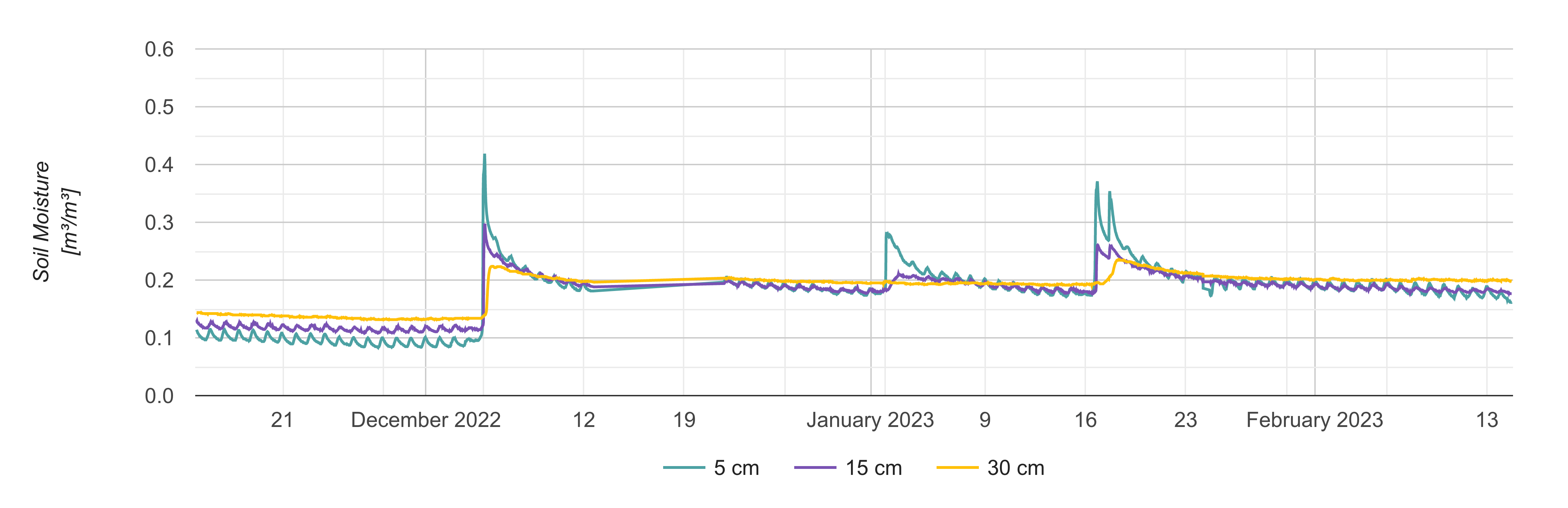
Figure 1. Root zone soil moisture at 5, 15, and 30 cm depth for a node in Lucky Hills, AZ.
Citation
Melebari, A., R. Akbar, E. Hodges, D. Mckague, C.S. Ruf, A.R. Silva, M. Moghaddam, R. Shrestha, C.J. Lindsley, T.R. Walker, and B.E. Wilson. 2023. Soil Moisture Profiles and Temperature Data from SoilSCAPE Sites, Version 2. ORNL DAAC, Oak Ridge, Tennessee, USA. https://doi.org/10.3334/ORNLDAAC/2049
Table of Contents
- Dataset Overview
- Data Characteristics
- Application and Derivation
- Quality Assessment
- Data Acquisition, Materials, and Methods
- Data Access
- References
- Dataset Revisions
Dataset Overview
This dataset contains in-situ soil moisture profile and soil temperature data collected at 30-minute intervals at SoilSCAPE (Soil moisture Sensing Controller and oPtimal Estimator) project sites since 2021 in the United States and New Zealand. The SoilSCAPE network has used wireless sensor technology to acquire high temporal resolution soil moisture and temperature data over varying durations since 2011. Since 2021, the SoilSCAPE has upgraded the two previously active sites in Arizona and added several new sites in the United States and New Zealand. These new sites typically use the METER Teros-12 soil moisture sensor. At its maximum, the new network consisted of 57 wireless sensor installations (nodes), with a range of 6 to 8 nodes per site. Each SoilSCAPE site contains multiple wireless end-devices (EDs). Each ED supports up to five soil moisture probes typically installed at 5, 10, 20, and 30 cm below the surface. Sites in Arizona have soil moisture probes installed at up to 75 cm below the surface. Soil conditions (e.g., hard soil or rocks) may have limited sensor placement.
The data enables estimation of local-scale soil moisture at high temporal resolution and validation of remote sensing estimates of soil moisture at regional and national (e.g. NASA's Cyclone Global Navigation Satellite System - CYGNSS and Soil Moisture Active Passive - SMAP) scales.
Related DataSet
Moghaddam, M., A.R. Silva, D. Clewley, R. Akbar, S.A. Hussaini, J. Whitcomb, R. Devarakonda, R. Shrestha, R.B. Cook, G. Prakash, S.K. Santhana Vannan, and A.G. Boyer. 2017. Soil Moisture Profiles and Temperature Data from SoilSCAPE Sites, USA. ORNL DAAC, Oak Ridge, Tennessee, USA. https://doi.org/10.3334/ORNLDAAC/1339
- This dataset contains data from active SoilSCAPE sites in or prior to 2021. These measurements were typically collected using the EC-5 and 5-TM soil moisture sensors from Decagon Devices.
Related Publication:
Akbar, R., J. Cambell, A.R. Silva, R. Chen, A. Melebari, and E. Hodges, D. Entekhabi, C. Ruf, and M. Moghaddam. 2020. "Soilscape Wireless in Situ Networks in Support of CYNGSS Land Applications," IGARSS 2020 - 2020 IEEE International Geoscience and Remote Sensing Symposium, 2020, pp. 5042-5044, https://doi.org/10.1109/IGARSS39084.2020.9324648
Dorigo, W., I. Himmelbauer, D. Aberer, L. Schremmer, I. Petrakovic, L. Zappa, W. Preimesberger, A. Xaver, F. Annor, J. Ardö, D. Baldocchi, D. Bitelli, G. Blöschl, H. Bogena, L. Brocca, J.-C. Calvet, J.J. Camarero, G. Capello, M. Choi, M.C. Cosh, N. van de Giesen, I. Hajdu, J. Ikonen, K.H. Jensen, K.D. Kanniah, I. de Kat, G. Kirchengast, P. Kumar Rai, J. Kyrouac, K. Larson, S. Liu, A. Loew, M. Moghaddam, J. Martínez Fernández, C. Mattar Bader, R. Morbidelli, J.P. Musial, E. Osenga, M.A. Palecki, T. Pellarin, G.P. Petropoulos, I. Pfeil, J. Powers, A. Robock, C. Rüdiger, U. Rummel, M. Strobel, Z. Su, R. Sullivan, T. Tagesson, A. Varlagin, M. Vreugdenhil, J. Walker, J. Wen, F. Wenger, J.P. Wigneron, M. Woods, K. Yang, Y. Zeng, X. Zhang, M. Zreda, S. Dietrich, A. Gruber, P. van Oevelen, W. Wagner, K. Scipal, M. Drusch, and R. Sabia. 2021. The International Soil Moisture Network: serving Earth system science for over a decade, Hydrol. Earth Syst. Sci., 25, 5749–5804, https://doi.org/10.5194/hess-25-5749-2021
Data Characteristics
Spatial Coverage: USA and New Zealand.
Spatial resolution: Point Locations.
Temporal Coverage: These data cover the period 2021-12-03 to the present. Sampling is continuing at active sites, and data are updated weekly.
Temporal Resolution: 30 minutes
Study Area: (all latitudes and longitudes given in decimal degrees)
| Site | Westernmost Longitude | Easternmost Longitude | Northernmost Latitude | Southernmost Latitude |
|---|---|---|---|---|
| USA | -110.0532 | 174.5559 | 37.19538 | -36.70378 |
Table 1. SoilSCAPE Sites. * Inactive sites.
| Site | Number of nodes | Temperature Measured | Start Date | End Date | Westernmost Longitude | Easternmost Longitude | Northernmost Latitude | Southernmost Latitude |
| Kendall, AZ, USA | 9 | Yes | 2022-08-17 | - | -109.946 | -109.940 | 31.737 | 31.735 |
| Lucky Hills, AZ, USA | 7 | Yes | 2021-08-15 | - | -110.052 | -110.053 | 31.744 | 31.742 |
| CO-Z1, CO, USA | 4 | Yes | 2021-12-03 | - | -105.996 | -105.824 | 37.195 | 37.055 |
| CO-Z4, CO, USA | 1 | Yes | 2021-12-04 | - | -105.824 | -105.824 | 37.055 | 37.055 |
| JR-1, NM, USA | 4 | Yes | 2022-05-04 | - | -106.740 | -106.736 | 32.523 | 32.516 |
| JR-2, NM, USA | 5 | Yes | 2022-05-04 | - | -106.787 | -106.778 | 32.592 | 32.589 |
| JR-3, NM, USA | 4 | Yes | 2022-05-04 | - | -106.741 | -106.732 | 32.613 | 32.608 |
| Ararimu, NZ | 5 | Yes | 2022-4-20 | - | 174.555 | 174.553 | -36.701 | -36.703 |
| Riverhead, NZ | 3 | Yes | 2022-09-08 | - | 174.616 | 174.612 | -36.746 | -36.714 |
| Wharekapua, NZ | 5 | Yes | 2022-04-23 | - | 173.057 | 173.047 | -34.717 | -34.721 |
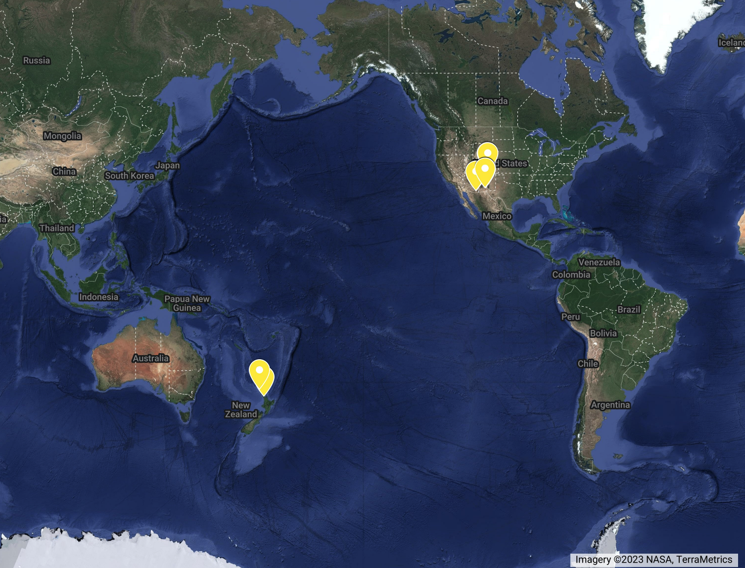
Figure 2. SoilSCAPE site locations.
Data File Information
This dataset includes 43 files in NetCDF format for 30-min interval data for soil moisture and soil temperature. The locations of the sites are provided in Table 1. The file names use the file naming convention of "soil_moist_30min_aaa_XX_nNNNN.nc" where aaa=Name of site (each site contains multiple notes); XX=State or country abbreviations (e.g. CO, NM, NZ); and NNNN is the Node ID (physicalid).
Table 2. Data fields.
| Data Field | Units | Description |
|---|---|---|
| time | minutes since 2011-01-01 | Date and time of the data collection |
| physicalid | Physical identifier of the node | |
| lat | decimal degrees | Latitude of the node |
| lon | decimal degrees | Longitude of the node |
| soil_moisture | m3/m3 | Volumetric soil moisture at various soil depths in m^3/m^3. |
| soil_quality_bit | A four-digit binary flag for soil moisture.
|
|
| soil_quality_flag | One-digit soil moisture flag.
|
|
| depth | cm | Depth at which the soil moisture and temperature sensors are placed |
| sensor | Type of the soil moisture sensor (e.g., Teros-12) | |
| temperature | degrees Celsius (C) | Soil temperature at various soil depths |
| temp_quality_bit | A four-digit binary flag for soil temperature.
|
|
| temp_quality_flag | One-digit soil temperature flag.
|
Application and Derivation
This dataset can be used for:
(1) Generation of local scale estimates of soil moisture at high temporal resolution. The point measurements from the sensor are scaled up to regional level hydrological models to produce local estimates of soil moisture.
(2) Validation of remote sensing based estimates of soil moisture. Soil moisture information from various SoilSCAPE sites will be used by various NASA Cyclone Global Navigation Satellite System (CYGNSS) Science Team members for soil moisture product calibration, validation, and assessment.
Quality Assessment
Uncertainty in the data was not quantified.
Quality flags for soil moisture/temperature are provided in data files (0=recommended and 1 = not recommended for use). Additional quality bit information of the probe status are also provided as separate variables. For more details, see Table 2.
Data Acquisition, Materials, and Methods
The soil moisture sensors were typically METER Teros-12 installed at different depths (usually at 5, 10, 20, and 30 cm) below the soil surface. Sites in Arizona have soil moisture probes installed up to 75 cm below the surface. The sensor was held in place by fastening it to a t-post. We used flexible conduit to shield wires from both cattle and burrowing animals such as rodents and badgers.
The sensors communicated with a local coordinator which wirelessly sent the data to the data server located at the University of Southern California (Figure 3).
The optimal placement of the sensors in time and space is achieved using the steady-state soil moisture statistics and surface state distribution of soil moisture in the area of interest weighed against the cost of communication associated with the sensor placement. The system uses the wireless sensor architecture called Ripple (Silva et al., 2012), which has undergone a number of improvements over the years.
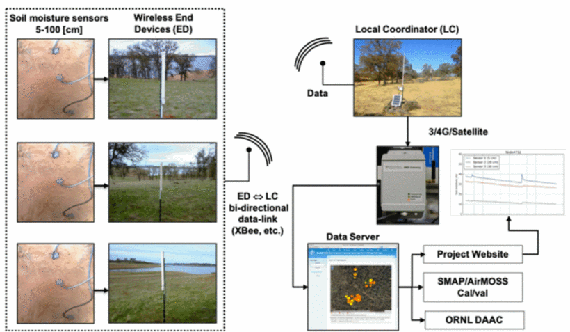
Figure 3. The wireless architecture of the SoilSCAPE network (Akbhar et al., 2020).
Data Access
These data are available through the Oak Ridge National Laboratory (ORNL) Distributed Active Archive Center (DAAC).
Soil Moisture Profiles and Temperature Data from SoilSCAPE Sites, Version 2
Contact for Data Center Access Information:
- E-mail: uso@daac.ornl.gov
- Telephone: +1 (865) 241-3952
References
Akbar, R., J. Cambell, A.R. Silva, R. Chen, A. Melebari, and E. Hodges, D. Entekhabi, C. Ruf, and M. Moghaddam. 2020. "Soilscape Wireless in Situ Networks in Support of Cyngss Land Applications," IGARSS 2020 - 2020 IEEE International Geoscience and Remote Sensing Symposium, 2020, pp. 5042-5044, https://doi.org/10.1109/IGARSS39084.2020.9324648
Dorigo, W., I. Himmelbauer, D. Aberer, L. Schremmer, I. Petrakovic, L. Zappa, W. Preimesberger, A. Xaver, F. Annor, J. Ardö, D. Baldocchi, D. Bitelli, G. Blöschl, H. Bogena, L. Brocca, J.-C. Calvet, J.J. Camarero, G. Capello, M. Choi, M.C. Cosh, N. van de Giesen, I. Hajdu, J. Ikonen, K.H. Jensen, K.D. Kanniah, I. de Kat, G. Kirchengast, P. Kumar Rai, J. Kyrouac, K. Larson, S. Liu, A. Loew, M. Moghaddam, J. Martínez Fernández, C. Mattar Bader, R. Morbidelli, J.P. Musial, E. Osenga, M.A. Palecki, T. Pellarin, G.P. Petropoulos, I. Pfeil, J. Powers, A. Robock, C. Rüdiger, U. Rummel, M. Strobel, Z. Su, R. Sullivan, T. Tagesson, A. Varlagin, M. Vreugdenhil, J. Walker, J. Wen, F. Wenger, J.P. Wigneron, M. Woods, K. Yang, Y. Zeng, X. Zhang, M. Zreda, S. Dietrich, A. Gruber, P. van Oevelen, W. Wagner, K. Scipal, M. Drusch, and R. Sabia. 2021. The International Soil Moisture Network: serving Earth system science for over a decade, Hydrol. Earth Syst. Sci., 25, 5749–5804, https://doi.org/10.5194/hess-25-5749-2021
Melebari, A. et al., "CYGNSS SoilSCAPE Sites: Sensor Calibration and Data Analysis," IGARSS 2023 - 2023 IEEE International Geoscience and Remote Sensing Symposium, Pasadena, CA, USA, 2023, pp. 4628-4630, https://doi.org/10.1109/IGARSS52108.2023.10282411
Moghaddam, M., D. Entekhabi, Y. Goykhman, K. Li, M. Liu, A. Mahajan, A. Nayyar, D. Shuman, and D. Teneketzis. 2010. A wireless soil moisture smart sensor web using physics-based optimal control: concept and initial demonstration IEEE-JSTARS, vol. 3, no. 4, pp. 522-535, December 2010
Moghaddam, M., A.R. Silva, D. Clewley, R. Akbar, S.A. Hussaini, J. Whitcomb, R. Devarakonda, R. Shrestha, R.B. Cook, G. Prakash, S.K. Santhana Vannan, and A.G. Boyer. 2017. Soil Moisture Profiles and Temperature Data from SoilSCAPE Sites, USA. ORNL DAAC, Oak Ridge, Tennessee, USA. https://doi.org/10.3334/ORNLDAAC/1339
Silva, A., M. Liu, and M. Moghaddam. 2012. Ripple-2 : A Non-Collaborative, Asynchronous, and Open Architecture for Highly-Scalable and Low Duty-Cycle WSNs. ACM MiSENET, August 2012, Istanbul, Turkey.
Thornton, P.E., M.M. Thornton, B.W. Mayer, Y. Wei, R. Devarakonda, R.S. Vose, and R.B. Cook. 2016. Daymet: Daily Surface Weather Data on a 1-km Grid for North America, Version 3. ORNL DAAC, Oak Ridge, Tennessee, USA. http://dx.doi.org/10.3334/ORNLDAAC/1328
Dataset Revisions
| Version | Description | Published |
| 2 | This is the Version 2 release of the dataset, which contains data from active SoilSCAPE sites since 2021. These measurements were typically collected using the METER Teros-12 soil moisture sensor. The data will continuously be updated on a weekly interval. |
2023-02-24 |
| 1 | Soil Moisture Profiles and Temperature Data from SoilSCAPE Sites. This is the Version 1 release of the dataset which contains data from active SoilSCAPE sites in or prior to 2021. These measurements were typically collected using the EC-5 and 5-TM soil moisture sensors from Decagon Devices. | 2016-09-16 |