Documentation Revision Date: 2025-12-08
Dataset Version: 2
Summary
There is one data file in cloud-optimized GeoTIFF format.
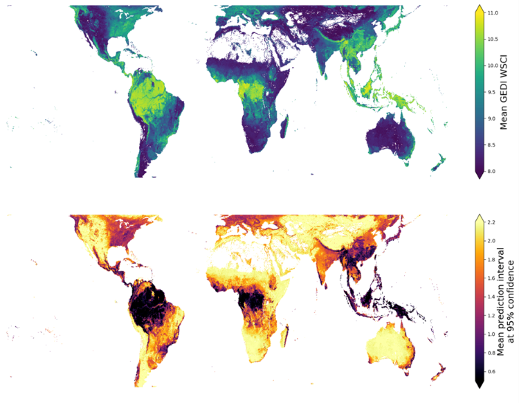
Figure 1. Mean Waveform Structural Complexity Index (WSCI) estimates (top) and absolute prediction intervals at 95% confidence (bottom) of high-quality GEDI footprints at 1-km resolution.
Citation
De Conto, T., J. Armston, and R.O. Dubayah. 2025. GEDI L4C Gridded Waveform Structural Complexity Index, Version 2. ORNL DAAC, Oak Ridge, Tennessee, USA. https://doi.org/10.3334/ORNLDAAC/2470
Table of Contents
- Dataset Overview
- Data Characteristics
- Application and Derivation
- Quality Assessment
- Data Acquisition, Materials, and Methods
- Data Access
- References
Dataset Overview
This dataset consists of gridded average estimates of Waveform Structural Complexity Index (WSCI) at 1-km resolution on a nearly global scale derived from the Global Ecosystem Dynamics Investigation (GEDI) Level 4C (L4C) footprint-level WSCI data covering the observations starting on 2019-04-18 to 2023-03-17. Mean WSCI values were computed from high quality GEDI shots over the land surface, according to the quality flags available in the GEDI L4C dataset. This dataset enables users to assess spatial patterns of forest structural complexity at a coarse scale anywhere within the GEDI domain without the need to acquire and process GEDI footprint data.
This GEDI L4C Gridded product aggregates the sparse footprint samples of GEDI's footprint-level WSCI estimates (De Conto et al., 2024) into a 1-km resolution near global map. The gridded layers are the averaged mean WSCI estimates and absolute prediction intervals at 95% confidence of all high-quality footprints observed within for the period 2019-04-17 to 2023-03-17. No interpolation or modeling was performed to generate this gridded dataset, meaning that only 1-km cells where high-quality GEDI footprints were observed are represented.
The GEDI instrument produces high-resolution laser ranging observations of the 3-dimensional structure of the Earth. The GEDI instrument consists of three lasers producing a total of eight beam ground transects, which consist of ~25 m footprint samples spaced approximately every 60 m along-track. The GEDI beam transects are spaced approximately 600 m apart on the Earth’s surface in the cross-track direction, for an across-track width of ~4.2 km. GEDI’s precise measurements of forest canopy height, canopy vertical structure, and surface elevation greatly advance our ability to characterize important carbon and water cycling processes, biodiversity, and habitat.
Project: Global Ecosystem Dynamics Investigation (GEDI)
The Global Ecosystem Dynamics Investigation (GEDI) produces high resolution laser ranging observations of the 3D structure of the Earth. GEDI’s precise measurements of forest canopy height, canopy vertical structure, and surface elevation greatly advance our ability to characterize important carbon and water cycling processes, biodiversity, and habitat. GEDI was funded as a NASA Earth Ventures Instrument (EVI) mission. It was launched to the International Space Station in December 2018 and completed initial orbit checkout in April 2019.
Related Publication
De Conto, T., J. Armston, and R. Dubayah. 2024. Characterizing the structural complexity of the Earth’s forests with spaceborne lidar. Nature Communications 15:8116. https://doi.org/10.1038/s41467-024-52468-2
Related Datasets
De Conto, T., J. Armston, and R.O. Dubayah. 2024. Global Ecosystem Dynamics Investigation (GEDI) GEDI L4C Footprint Level Waveform Structural Complexity Index, Version 2. ORNL Distributed Active Archive Center. https://doi.org/10.3334/ORNLDAAC/2338
Acknowledgements
This work was funded with a NASA Earth Ventures Instrument (EVI) supporting the GEDI mission (contract NNL15AA03C), and FINESST (grant NNH21ZDA001N).
Data Characteristics
Spatial Coverage: Global within a nominal latitude extent of -52 to +52 degrees
Spatial Resolution: 1 km
Temporal Coverage: 2019-04-18 to 2023-03-17
Temporal Resolution: One-time estimate
Study Area: Latitude and longitude are given in decimal degrees
| Site | Westernmost Longitude | Easternmost Longitude | Northernmost Latitude | Southernmost Latitude |
|---|---|---|---|---|
| Global | -180 | 180 | 52.524 | -53.246 |
Data File Information
This dataset contains a single cloud-optimized GeoTIFF file: GEDI_L4C_WSCI_gridded_1km_20190418_20230317_V2.tif.
The GeoTIFF has two bands: (1) averaged mean WSCI estimates at 1-km resolution, and (2) absolute prediction intervals at 95% confidence of all high-quality footprints observed within the period 2019-04-18 to 2023-03-17.
GeoTIFF characteristics
- Projected coordinate system: WGS 84 / NSIDC EASE-Grid 2.0 Global (EPSG: 6933), Proj4 = "+proj=cea +lat_ts=30 +lon_0=0 +x_0=0 +y_0=0 +datum=WGS84 +units=m"
- Spatial resolution: 1000 m
- Number of bands: 2
- Data type: Float32
- Nodata value: -9999
Application and Derivation
The GEDI L4C WSCI footprint product (De Conto et al., 2024b) provides estimates of 3D structural complexity at a near-global extent. The sparse sampling pattern of GEDI limits spatial continuity of WSCI estimates (De Conto et al., 2024a; Dubayah et al., 2020) and broad scale assessments based on GEDI data require acquiring large amounts of footprint level data. This dataset facilitates regional and global scale assessments of forest structural complexity by providing a single map with aggregated estimates at a coarse scale, enabling users to quickly explore spatial patterns of structural complexity without the need to download and process large amounts of footprint data.
Quality Assessment
This dataset simply aggregates footprint estimates of the GEDI L4C product (De Conto et al., 2024b). All quality assessments and uncertainty analysis are described in the GEDI L4C footprint level product’s page (De Conto et al., 2024b) and its accompanying paper (De Conto et al., 2024a).
Data Acquisition, Materials, and Methods
This gridded dataset aggregates footprint estimates of the GEDI L4C product (De Conto et al., 2024b). It used only high-quality GEDI footprints over the land surface to derive mean and uncertainty estimates at 1-km scale. The high-quality flag is available as “wsci_quality_flag” in the GEDI L4C footprint product (De Conto et al., 2024b), and land cover type information was derived from the ESA world cover product (Zanaga et al. 2022) provided as the “worldcover_class” variable for every footprint in the L4C product.
Details about the WSCI metric are available in De Conto et al. (2024a; 2024b).
Data Access
These data are available through the Oak Ridge National Laboratory (ORNL) Distributed Active Archive Center (DAAC).
GEDI L4C Gridded Waveform Structural Complexity Index, Version 2
Contact for Data Center Access Information:
- E-mail: uso@daac.ornl.gov
- Telephone: +1 (865) 241-3952
References
De Conto, T., J. Armston, and R. Dubayah. 2024a. Characterizing the structural complexity of the Earth’s forests with spaceborne lidar. Nature Communications 15:8116. https://doi.org/10.1038/s41467-024-52468-2
De Conto, T., J. Armston, and R. Dubayah. 2024b. Global Ecosystem Dynamics Investigation (GEDI) GEDI L4C Footprint Level Waveform Structural Complexity Index, Version 2. https://doi.org/10.3334/ORNLDAAC/2338
Dubayah, R., J.B. Blair, S. Goetz, L. Fatoyinbo, M. Hansen, S. Healey, M. Hofton,G. Hurtt, J. Kellner, S. Luthcke, J. Armston, H. Tang, L. Duncanson, S. Hancock, P. Jantz, S. Marselis, P.L. Patterson,W. Qi, and C. Silva. 2020. The Global Ecosystem Dynamics Investigation: High-resolution laser ranging of the Earth’s forests and topography. Science of Remote Sensing 1:100002.
https://doi.org/10.1016/j.srs.2020.100002
Zanaga, D., Van De Kerchove, R., Daems, D., De Keersmaecker, W., Brockmann, C., Kirches, G., Wevers, J., Cartus, O., Santoro, M., Fritz, S., Lesiv, M., Herold, M., Tsendbazar, N.-E., Xu, P., Ramoino, F., Arino, O., 2022. ESA WorldCover 10 m 2021 v200. Zenodo. https://doi.org/10.5281/ZENODO.7254221