Documentation Revision Date: 2023-12-06
Dataset Version: 1
Summary
This dataset includes two data files in comma-separated values (*.csv) format. The files include country_estimates_gedi_l4b_v002.csv (GEDI L4B Version 2, period 2019-04-18 to 2021-08-04, mission weeks 19 to 138) and country_estimates_gedi_l4b_v021.csv (GEDI L4B Version 2.1, period 2019-04-18 to 2023-03-16, mission weeks 19 to 223). The statistics from the GEDI L4B Version 2.1 and a comparison with the GEDI L4B Version 2 are summarized in the companion file: summary_country_estimates_agbd.pdf.
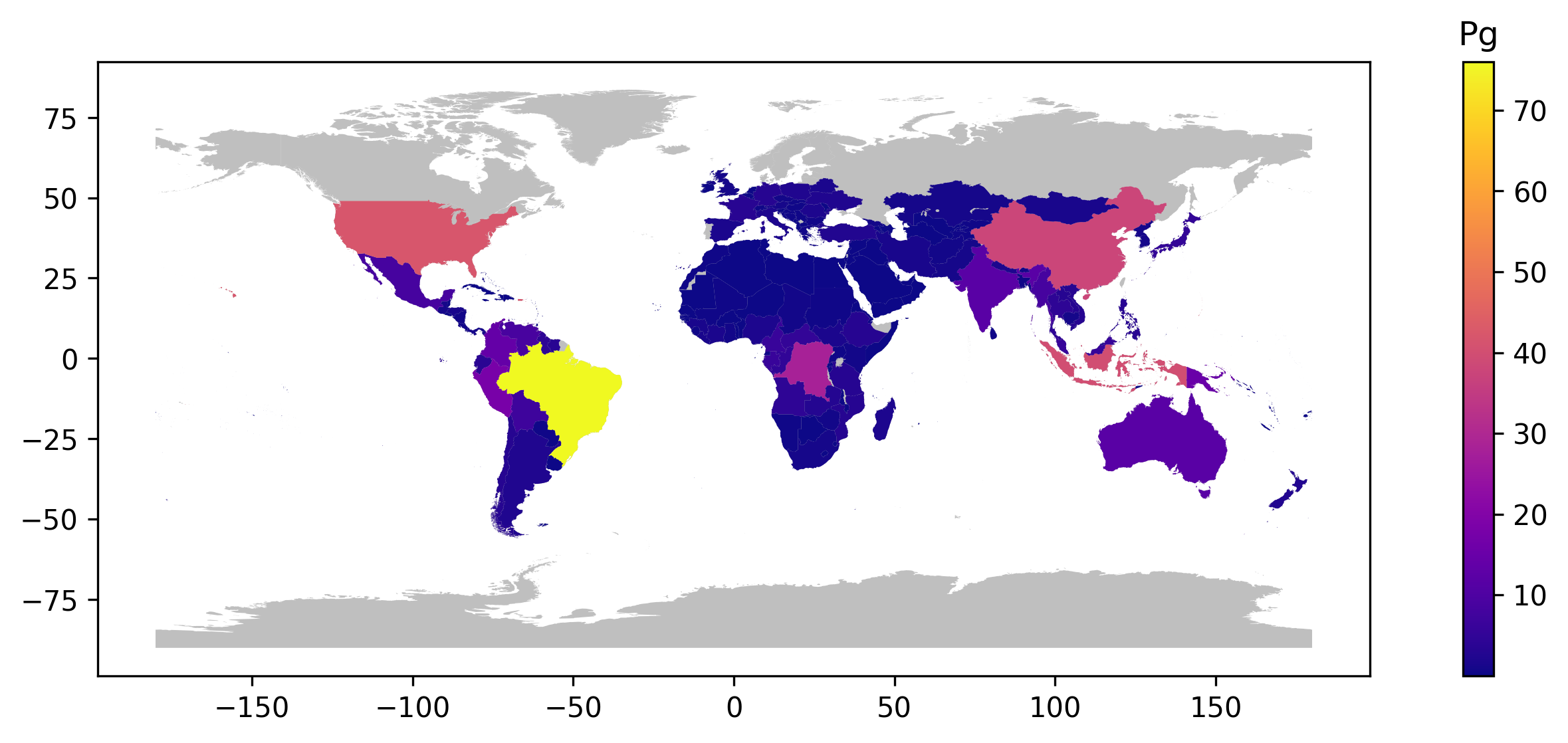
Figure 1. Country-wide estimates of total aboveground biomass (GEDI_L4B_AGB) in peta grams (Pg) using GEDI L4B Version 2.1 dataset.
Citation
Armston, J., R.O. Dubayah, S.P. Healey, Z. Yang, P.L. Patterson, S. Saarela, G. Stahl, L. Duncanson, J.R. Kellner, A. Pascual, and J. Bruening. 2023. GEDI L4B Country-level Summaries of Aboveground Biomass. ORNL DAAC, Oak Ridge, Tennessee, USA. https://doi.org/10.3334/ORNLDAAC/2321
Table of Contents
- Dataset Overview
- Data Characteristics
- Application and Derivation
- Quality Assessment
- Data Acquisition, Materials, and Methods
- Data Access
- References
Dataset Overview
This dataset provides country-scale estimates of land surface mean aboveground biomass density (AGBD), total aboveground biomass (AGB) stocks, and the associated standard errors of the mean calculated using different versions of the Global Ecosystem Dynamics Investigation (GEDI) Level-4B (L4B) product. The GEDI L4B product provides gridded (1 km x 1 km) estimates of AGBD within the GEDI orbital extent (between 51.6 degrees N and 51.6 degrees S). For comparison purposes, this dataset also includes national-scale National Forest Inventory (NFI) estimates of AGBD from the 2020 Global Forest Resources Assessment (FRA) published by the Food and Agriculture Organization (FAO, 2020) of the United Nations.
The GEDI instrument produces high-resolution laser ranging observations of the 3-dimensional structure of the Earth's surface. GEDI was launched on December 5, 2018, and is attached to the International Space Station (ISS). The GEDI instrument consists of three lasers producing a total of eight beam ground transects, which consist of ~25 m footprint samples spaced approximately every 60 m along-track. The GEDI beam transects are spaced approximately 600 m apart on the Earth's surface in the cross-track direction, for an across-track width of ~4.2 km.
There are two data files as comma-separated values (*.csv) format included in this dataset. The files include country_estimates_gedi_l4b_v002.csv (GEDI L4B Version 2, period 2019-04-18 to 2021-08-04, mission weeks 19 to 138) and country_estimates_gedi_l4b_v021.csv (GEDI L4B Version 2.1, period 2019-04-18 to 2023-03-16, mission weeks 19 to 223). The statistics from the GEDI L4B Version 2.1 and a comparison with the GEDI L4B Version 2 are summarized in the companion file: summary_country_estimates_agbd.pdf.
Project: Global Ecosystem Dynamics Investigation
The Global Ecosystem Dynamics Investigation (GEDI) produces high-resolution laser ranging observations of the 3D structure of the Earth. GEDI’s precise measurements of forest canopy height, canopy vertical structure, and surface elevation greatly advance our ability to characterize important carbon and water cycling processes, biodiversity, and habitat. GEDI was funded as a NASA Earth Ventures Instrument (EVI) mission. It was launched to the International Space Station in December 2018 and completed initial orbit checkout in April 2019.
Related Publications
Dubayah, R., Armston, J., Healey, S.P., Bruening, J.M., Patterson, P.L., Kellner, J.R., Duncanson, L., Saarela, S., Ståhl, G., Yang, Z., Tang, H., Blair, J.B., Fatoyinbo, L., Goetz, S., Hancock, S., Hansen, M., Hofton, M., Hurtt, G., Luthcke, S., 2022. GEDI launches a new era of biomass inference from space. Environmental Research Letters 17(9) 095001. https://doi.org/10.1088/1748-9326/ac8694
Related Datasets
Dubayah, R.O., J. Armston, S.P. Healey, Z. Yang, P.L. Patterson, S. Saarela, G. Stahl, L. Duncanson, J.R. Kellner, J. Bruening, and A. Pascual. 2023. GEDI L4B Gridded Aboveground Biomass Density, Version 2.1. ORNL DAAC, Oak Ridge, Tennessee, USA. https://doi.org/10.3334/ORNLDAAC/2299
Dubayah, R.O., J. Armston, S.P. Healey, Z. Yang, P.L. Patterson, S. Saarela, G. Stahl, L. Duncanson, and J.R. Kellner. 2022. GEDI L4B Gridded Aboveground Biomass Density, Version 2. ORNL DAAC, Oak Ridge, Tennessee, USA. https://doi.org/10.3334/ORNLDAAC/2017
Acknowledgments
This work was funded with a NASA Earth Ventures Instrument (EVI) (contract NNL15AA03C) and an inter-agency agreement (contract RPO201523) with the U.S. Forest Service Rocky Mountain Research Station. We thank the NASA Terrestrial Ecology Program for supporting the GEDI mission. The University of Maryland and the U.S. Forest Service have provided independent financial support. We thank Göran Ståhl, Svetlana Saarela, and Sören Holm of the Swedish University for Agricultural Sciences for contributions to statistical methods used in this data product.
Data Characteristics
Spatial Coverage: Global within a nominal latitude extent of -52 to 52 degrees
Spatial Resolution: Country resolution
Temporal Coverage: 2019-04-18 to 2023-03-16
Temporal Resolution: One-time estimate
Study Areas: Latitude and longitude are given in decimal degrees.
| Site | Westernmost Longitude | Easternmost Longitude | Northernmost Latitude | Southernmost Latitude |
|---|---|---|---|---|
| Global | 180.00 | -180.00 | 52.00 | -52.00 |
Data File Information
There are two data files in comma-separated values (*.csv) format and one companion file in Portable Document Format (*.pdf) format included in this dataset. The file “country_estimates_gedi_l4b_v002.csv” provides a country-level summary based on GEDI L4B Version 2 for the period 2019-04-18 to 2021-08-04 (GEDI mission weeks 19 to 138). The file “country_estimates_gedi_l4b_v021.csv” provides a country-level summary based on GEDI L4B Version 2.1 for the period 2019-04-18 to 2023-03-16 (GEDI mission weeks 19 to 223). The statistics from the GEDI L4B Version 2.1 and a comparison with the GEDI L4B Version 2 are summarized in the companion file “summary_country_estimates_agbd.pdf”. Companion files must be downloaded separately from the data files.
Missing data are indicated by -9999
Table 1.Variables in data files.
| Variable | Units | Description |
|---|---|---|
| Country | - | Name of country |
| ISO3 | - | Three-letter country codes defined in ISO 3166-1 international standard |
| Percent_Forest | percent | Percent area of the country covered by forest ( Food and Agriculture Organization - FAO - definition) |
| FAO_Forested_AGBD | Mg ha-1 | FAO estimates of mean aboveground biomass density for forested area within the country |
| FAO_Total_AGBD | Mg ha-1 | FAO estimates of mean aboveground biomass density for total country area |
| GEDI_L4B_Total_AGBD | Mg ha-1 | GEDI estimates of mean aboveground biomass density for total country area |
| GEDI_L4B_AGBD_SE | Mg ha-1 | GEDI estimates of standard errors of the mean aboveground biomass density in Mg ha -1 |
| GEDI_L4B_AGBD_SE_Percent | percent | GEDI estimates of standard errors of the mean aboveground biomass density in percentage |
| FAO_AGB | Pg C | FAO estimates of total aboveground biomass in peta grams (1 billion metric tons = 1 Pg) |
| GEDI_L4B_AGB | Pg C | GEDI estimates of total aboveground biomass in peta grams |
| GEDI_L4B_AGB_SE | Pg C | GEDI estimates of standard errors of the total aboveground biomass in peta grams |
Companion File
This dataset contains one companion file: summary_country_estimates_agbd.pdf. This file contains a summary of statistics from the GEDI L4B Version 2.1 and a comparison with the GEDI L4B Version 2.
Application and Derivation
This dataset provides estimates of AGBD (Mg ha-1) and AGB (Pg) aggregated to the national level for every country GEDI observes. This dataset serves as a baseline for current biomass stocks and their future changes.
Quality Assessment
The quality filtering is documented in Dubayah et al., (2022b). For country level estimates, only shots with a beam sensitivity >0.98 across all prediction strata were used to avoid systematic differences between prediction strata in the fraction of 6 km cells with fewer than two tracks. Large countries with a vast majority of land area within the ISS extent were also included, even if not entirely within the GEDI extent; specifically, China, Argentina, and Chile. The United States was also included but is a special case because of Alaska, and is described in Dubayah et al. (2022b). The computation of standard errors of the mean AGBD and algorithms used for quality filtering is described in the algorithm theoretical basis (ATBD) document of the GEDI L4B product (Healey et al., 2023).
Data Acquisition, Materials, and Methods
The methodology to estimate country mean, totals and associated uncertainty are presented in Dubayah et al. (2022b).
The GEDI instrument produces high-resolution laser ranging observations of the 3-dimensional structure of the Earth. GEDI was launched on December 5, 2018, and is attached to the International Space Station (ISS). GEDI collects data globally at the highest resolution and densest sampling of any light detection and ranging (lidar) instrument in orbit to date. The GEDI instrument consists of 3 lasers producing a total of 8 beam ground transects, which consist of ~25 m footprint samples spaced approximately every 60 m along-track. The GEDI beam transects are spaced approximately 600 m apart on the Earth’s surface in the cross-track direction, for an across-track width of ~4.2 km.
GEDI L4B gridded aboveground biomass density uses a hybrid estimation to create an exhaustive coverage of non-overlapping 1 km x 1 km mean biomass estimates with a grid of standard errors for each 1-km estimate. Please see Dubayah et al. (2023) for additional detail on this product.
The country-scale GEDI estimates of land surface mean aboveground Biomass Density (AGBD) and the associated standard errors were calculated for all countries contained within the GEDI orbital extent using the GEDI Level-4B (L4B) Version 2.1 product. The country boundaries were delineated using a 10 meter resolution vector dataset (Natural Earth, 2022). National-scale National Forest Inventory (NFI) estimates of AGBD were taken from the 2020 Global Forest Resources Assessment (FRA) published by the Food and Agriculture Organization (FAO, 2020) of the United Nations. FAO estimates are only for forested lands, whereas GEDI estimates are for all lands. To ensure a similar comparison to GEDI-based estimates, the estimates of AGBD of forested land, the area of forested land, and total land area were retrieved for every available country in the FRA online database. These values were used to calculate each country's mean land AGBD and total AGB. We also compare the GEDI Version 2 (https://doi.org/10.3334/ORNLDAAC/2017; Dubayah et al., 2022a) estimates from Dubayah et al. (2022b) with the revised estimates from GEDI L4B Version 2.1 (https://doi.org/10.3334/ORNLDAAC/2299; Dubayah et al., 2023). To ensure a similar comparison to GEDI-based estimates, we retrieved estimates of AGBD of forested land, the area of forested land, and the total land area for every available country in the FRA online database (FAO, 2020). For consistency with previous country-estimates the quality filtering documented in Dubayah et al. (2022b) was applied.
The GEDI mission aims to characterize ecosystem structure and dynamics to enable improved quantification and understanding of the Earth’s carbon cycle and biodiversity. GEDI is led by the University of Maryland in collaboration with NASA Goddard Space Flight Center. GEDI science data algorithms and products are created by the GEDI Science Team.
Data Access
These data are available through the Oak Ridge National Laboratory (ORNL) Distributed Active Archive Center (DAAC).
GEDI L4B Country-level Summaries of Aboveground Biomass
Contact for Data Center Access Information:
- E-mail: uso@daac.ornl.gov
- Telephone: +1 (865) 241-3952
References
Dubayah, R.O., J. Armston, S.P. Healey, Z. Yang, P.L. Patterson, S. Saarela, G. Stahl, L. Duncanson, and J.R. Kellner. 2022a. GEDI L4B Gridded Aboveground Biomass Density, Version 2. ORNL DAAC, Oak Ridge, Tennessee, USA. https://doi.org/10.3334/ORNLDAAC/2017
Dubayah, R., Armston, J., Healey, S. P., Bruening, J. M., Patterson, P. L., Kellner, J. R., Duncanson, L., Saarela, S., Ståhl, G., Yang, Z., Tang, H., Blair, J. B., Fatoyinbo, L., Goetz, S., Hancock, S., Hansen, M., Hofton, M., Hurtt, G., and Luthcke, S. 2022b. GEDI launches a new era of biomass inference from space. Environmental Research Letters, 17(9), 095001. https://doi.org/10.1088/1748-9326/ac8694
Dubayah, R.O., J. Armston, S.P. Healey, Z. Yang, P.L. Patterson, S. Saarela, G. Stahl, L. Duncanson, J.R. Kellner, J. Bruening, and A. Pascual. 2023. GEDI L4B Gridded Aboveground Biomass Density, Version 2.1. ORNL DAAC, Oak Ridge, Tennessee, USA. https://doi.org/10.3334/ORNLDAAC/2299
ESA WorldCover Validation report accessible: https://worldcover2021.esa.int/download
FAO. 2020. Global Forest Resources Assessment 2020: Main report. Rome. https://doi.org/10.4060/ca9825en
Healey, S.P., Patterson, P. L., and Armston, J. 2023. Algorithm Theoretical Basis Document (ATBD) for GEDI Level-4B (L4B) Gridded Aboveground Biomass Density. https://daac.ornl.gov/daacdata/gedi/GEDI_L4B_Gridded_Biomass_V2_1/comp/GEDI_L4B_ATBD_V2.0.pdf
Natural Earth. 2022. Natural Earth 1:10m cultural vectors—free vector and raster map data at 1:10m, 1:50m, and 1:110m scales (available at: www.naturalearthdata.com/downloads/10m-cultural-vectors/ )