Documentation Revision Date: 2017-09-28
Data Set Version: 1
Summary
There are nine data files with this dataset. This includes one compressed shapefile (.zip) with the locations of the sites, one compressed directory (.tar.gz) containing site data sheets, and seven comma-separated files (.csv) which provide the site locations, FLUXNET identifiers, investigator information, and bibliography.
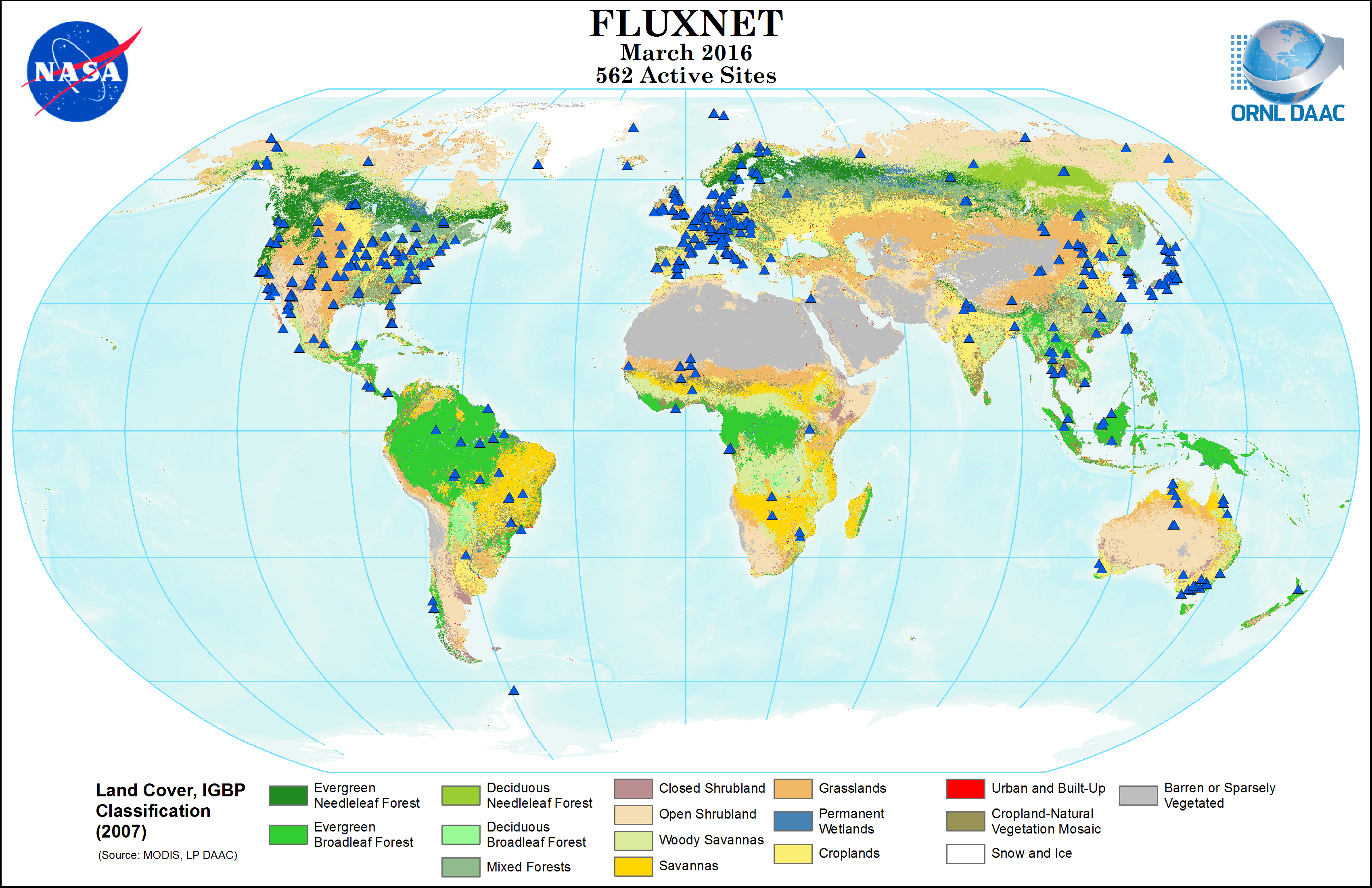
Figure 1. Active FLUXNET sites in March 2016 and land cover from MODIS IGBP classification. Site locations, land cover, and other environmental data is provided with this dataset. This image is included as a companion file: fluxnet_MODIS_IGBP_3-2016.png
Citation
Falge, E., M. Aubinet, P.S. Bakwin, D. Baldocchi, P. Berbigier, C. Bernhofer, T.A. Black, R. Ceulemans, K.J. Davis, A.J. Dolman, A. Goldstein, M.L. Goulden, A. Granier, D.Y. Hollinger, P.G. Jarvis, N. Jensen, K. Pilegaard, G. Katul, P. Kyaw Tha Paw, B.E. Law, A. Lindroth, D. Loustau, Y. Mahli, R. Monson, P. Moncrieff, E. Moors, J.W. Munger, T. Meyers, W. Oechel, E.-D. Schulze, H. Thorgeirsson, J. Tenhunen, R. Valentini, S.B. Verma, T. Vesala, and S.C. Wofsy. 2017. FLUXNET Research Network Site Characteristics, Investigators, and Bibliography, 2016. ORNL DAAC, Oak Ridge, Tennessee, USA. https://doi.org/10.3334/ORNLDAAC/1530
Table of Contents
- Data Set Overview
- Data Characteristics
- Application and Derivation
- Quality Assessment
- Data Acquisition, Materials, and Methods
- Data Access
- References
Data Set Overview
FLUXNET is a global network of micrometeorological tower sites that use eddy covariance methods to measure the exchanges of carbon dioxide, water vapor, and energy between terrestrial ecosystems and the atmosphere. This dataset provides information from the ORNL DAAC-hosted FLUXNET site database which was discontinued in 2016. The files provided contain a list of investigators associated with each tower site, site locations and environmental data, and a bibliography of papers that used FLUXNET data. For more up to date information on FLUXNET sites, see http://fluxnet.fluxdata.org/.
Project: FLUXNET
Related Dataset: The following dataset contains an archived copy of the ORNL DAAC's Fluxnet Website as of September 2017. It provides much of the same information contained in this dataset.
ORNL DAAC. 2017. Fluxnet: Archived Website Including Site and Investigator Information. ORNL DAAC, Oak Ridge, Tennessee, USA. https://doi.org/10.3334/ORNLDAAC/1549
Data Characteristics
Spatial Coverage: Fluxnet sites around the world
Spatial Resolution: Point locations
Temporal Coverage: Data covers 1991-01-01 to 2016-12-31
Temporal Resolution: Various
Study Area (All latitudes and longitudes are given in decimal degrees)
| Site | Westernmost Longitude | Easternmost Longitude | Northernmost Latitude | Southernmost Latitude |
|---|---|---|---|---|
| FLUXNET sites | -157.409 | 175.553889 | 78.921631 | -62. 232115 |
Data file information
There are nine data files with this dataset. This includes one compressed shapefile (.zip) with the locations of the sites, one compressed directory (.tar.gz) containing site data sheets, and seven comma-separated files (.csv). Sixteen companion files, including the shapefile data in .kmz (Google Earth) format, are also provided.
Table 1. Data file names and descriptions.
| File name | Description |
|---|---|
| fluxnet_sites.zip | Compressed shapefile (.shp) that provides site locations and environmental data |
| fluxnet_site_investigators.csv | Provides site IDs and ID numbers of the investigators for each site |
| fluxnet_site_info_all.csv | Provides location information |
| fluxnet_site_info.csv | Provides names, location, and site descriptions |
| fluxnet_site_data.csv | Provides site environmental data |
| fluxnet_mapbooks.tar.gz | Compressed directory containing 1,407 site data sheets in .png format. The data sheets provide location maps and overview of environmental conditions at each fluxnet site. |
| fluxnet_investigators.csv | Provides a list of investigators, by investigator ID, with contact information |
| fluxnet_calculated_data.csv | Provides a list of data variables for each site |
| fluxnet_bibliography_20160729.csv | Provides a bibliography of publications that used Fluxnet data from each site |
Shapefile
The shapefile (.shp) is provided in fluxnet_sites.zip. The following information is provided in the file.
| siteid | Internal database identifier for each site |
| fluxnetid | Site ID within the Fluxnet network |
| keyid | Unknown definition |
| sitename | Human readable site name |
| country | Country location of site |
| land_unit | Region location of site |
| status | Active/inactive status of site as of 2016-03-01 |
| latitude | Latitude coordinate |
| longitude | Longitude coordinate |
| year_began | Year the site started collecting data within the FLUXNET framework |
| network1 | Current site network |
| network2 | Previous site network |
| network3 | Other previous site network |
| koeppen_cl | Koppen-Geiger climate classification |
| igbp_land_ | Site land cover (MODIS IGBP classification) |
| umd_land_c | Site land cover (MODIS UMD classification) |
| lai_fpar | Site land cover (MODIS LAI/fpar classification) |
| npp_land_c | Site land cover (MODIS NPP classification) |
| plant_func | Unknown definition |
Comma-separated files (.csv)
There are seven comma-separated files (.csv) included in this dataset. Each file and its contents are listed below.
Table 2. Contents of the file fluxnet_site_data.csv
| Column name | Units/format | Description |
|---|---|---|
| siteid | FLUXNET site ID | |
| data_type_id | ||
| record_date | yyyy-mm-dd | |
| value | Landcover type-grassland, cropland, etc | |
| source | Source of data | |
| display | TRUE or FALSE | |
| start_date | yyyy-mm-dd | Date site became active |
| end_date | yyyy-mm-dd | Date site became inactive |
Table 3. Contents of the file fluxnet_site_info_all.csv
| Column name | Units/format | Description |
| siteid | FLUXNET numeric site ID | |
| fluxnetid | FLUXNET site ID | |
| keyid | Combination of site ID and country location | |
| sitename | FLUXNET site name | |
| countryid | Country where FLUXNET site is located | |
| land_unit | Region-location of FLUXNET site-North America, South America, Europe, Asia, Australia, Africa | |
| staus | Staus of site=Acitve or Inactive | |
| latitude | Decimal degrees | Latitude of site |
| longitude | Decimal degrees | Longitude of site |
| year_began | yyyy | Year site became active |
| network1 | Current FLUXNET network affiliation or null | |
| network2 | Previous FLUXNET network affiliation | |
| network3 | Other prior FLUXNET network affiliation | |
| koeppen_climate | Koppen-Geiger climate classification | |
| igbp_land_use | Site land cover (MODIS IGBP classification) | |
| umd_land_cover | Site land cover (MODIS UMD classification) | |
| lai_fpar | Site land cover (MODIS LAI/fPAR classification) | |
| npp_land_cover | Site land cover (MODIS NPP classification) | |
| plant_functional_type | Plant functional type surrounding site | |
| network1_id | Current FLUXNET network ID | |
| year_began | Year the site started collecting data within the FLUXNET framework |
Table 4. Contents of the file fluxnet_site_info.csv
| Column name | Description |
|---|---|
| siteid | FLUXNET numeric site ID |
| sitename | FLUXNET site name |
| stateid | State where site is located or (null) |
| countryid | Country where FLUXNET site is located |
| keyid | Combination of site ID and country location |
| description | Description of the FLUXNET site location |
Table 5. Contents of the file fluxnet_investigators.csv
This file provides contact information pertaining to the FLUXNET investigators and their affiliated FLUXNET site IDs.
| Column name |
|---|
| siteid |
| firstname |
| middlename |
| lastname |
| title |
| position |
| description |
| Phone |
| Fax |
| institution |
| Address1 |
| Address2 |
| Address3 |
| investigator_url |
| comments |
Table 6. Contents of the file fluxnet_site_investigators.csv
| Column name | Units/format | Description |
| siteid | FLUXNET numeric site ID | FLUXNET numeric site ID |
| investigatorid | Investigator ID number | |
| start_date | yyyy-mm-dd | start of time associated with this site |
| pi | Principal Investigator=yes or no | |
| end_date | yyyy-mm-dd | |
| comments | ||
| display_order | Numeric |
Table 7. Contents of the file fluxnet_calculated_data.csv. Climate and other ancillary data for each site was gathered from various sources and used to create Figure 2 and several other plots included as companion files.
| Column name | Description |
|---|---|
| myid2 | Investigator ID |
| lastname | Last name of investigator |
| firstname | First name of investigator |
| modis_file | Modis file |
| ceip_code | Combined FLUXNET site ID code with network |
| pnet | Network |
| siteid | FLUXNET site ID |
| keyid | |
| network | FLUXNET network |
| site_type | |
| status | Active or inactive |
| year_began | Year site became active |
| sitename | FLUXNET site name |
| country | Country where FLUXNET site is located |
| state | State where FLUXNET site is located |
| land_unit | Region location of FLUXNET site |
| latitude | Latitude of FLUXNET site |
| longitude | Longitude of FLUXNET site |
| cluster | |
| evapck | Evaporation |
| evap | Evaporation |
| precck | Precipitation |
| prec | Precipitation |
| tprec | Precipitation |
| sunck | |
| usn | |
| maxtck | Maximum temperature |
| maxt | Maximum temperature |
| mintck | Minimum temperature |
| mint | Minimum temperature |
| mmt | |
| vp | Vapor |
| ws | |
| igbp | Site land cover (MODIS IGBP classification) |
| umd | Site land cover (MODIS UMD classification) |
| lai_fpar | Site land cover (MODIS LAI/fPAR classification) |
| npp | Site land cover (MODIS NPP classification) code |
| ppt | Site land cover code |
| elev | Elevation |
| koeppen | Koppen-Geiger climate classification code |
| myid | |
| igbp_def | Site land cover code (MODIS IGBP classification) and definition |
| umd_def | Site land cover code (MODIS UMD classification) and definition |
| laif_def | Site land cover (MODIS LAI/fPAR classification) and definition |
| npp_def | Site land cover (MODIS NPP classification) code and definition |
| ppt_def | Site land cover code and definition |
| kop_def | Koppen-Geiger climate classification code definition |
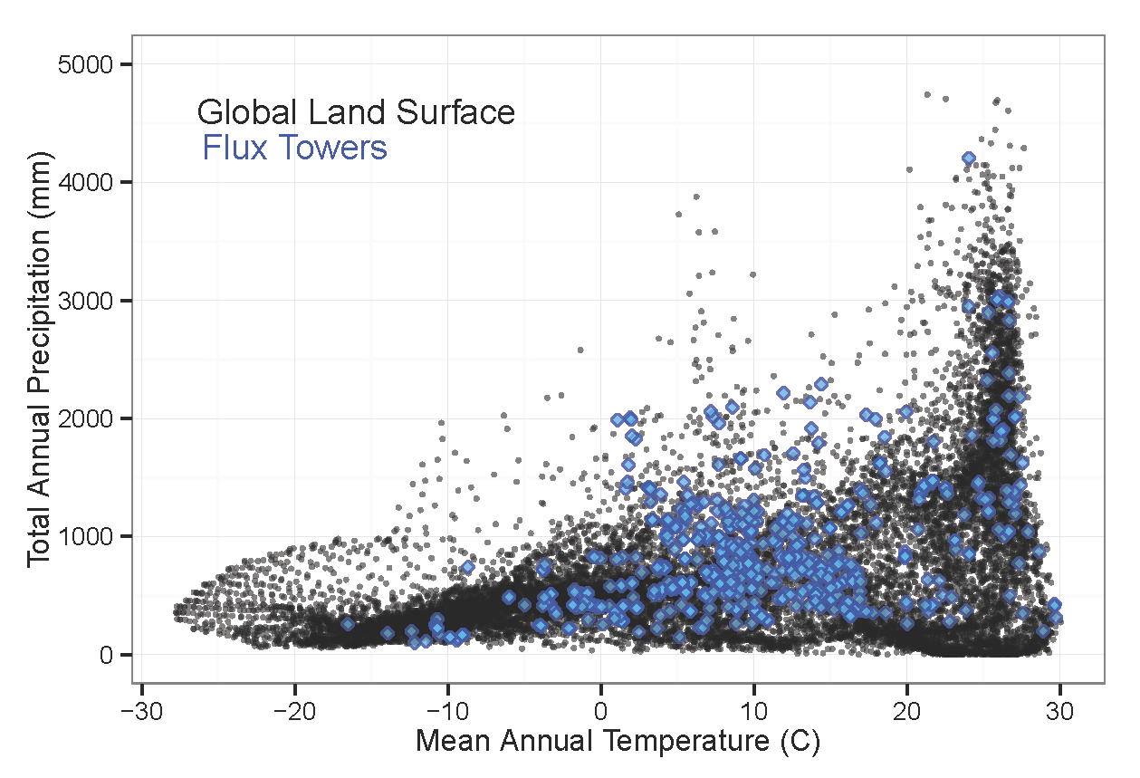
Figure 2: Calculated mean annual temperature and total annual precipitation for all active Fluxnet sites (blue diamonds; as of March 2016) as compared to the climatic regimes of one-degree grid cells for the Earth's land surface area. This image is included as a companion file: fluxnet_Climate.png.
Table 8. The file fluxnet_bibliography_20160729.csv contains a list of publications that used FLUXNET program data. Each paper is associated with one or more sites.
| Column name |
|---|
| site |
| authors |
| title |
| year |
| journal |
| issue |
| pages |
| DOI |
Site data sheets (mapbooks)
| fluxnet_mapbooks.tar.gz |
When uncompressed, this file contains 1,407 site data sheets in .png format showing a variety of environmental conditions at each fluxnet site. The individual files are named by the fluxnet site ID. See Fig 3 for an example. |
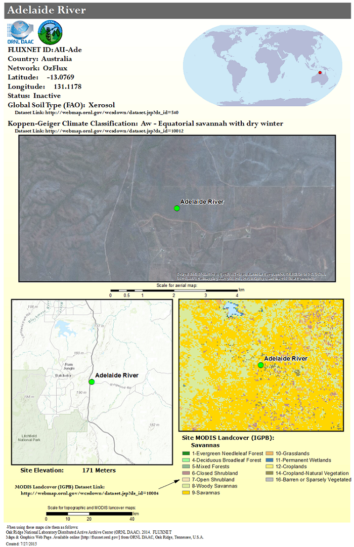
Figure 3: An example of the site data sheets, or mapbooks, provided for each site. This data sheet shows climate, land cover, and topography for the Adelaide River site (ID 2856) in Australia.
Companion files
Table 9. There are 16 companion files provided and each is described below.
| Companion file name | Description |
|---|---|
| fluxnet_UMDLandcover_3-2016_ShadedPoints.png | Global map of FLUXNET sites with locations shaded per UMD landcover classification |
| fluxnet_UMDLandcover_3-2016.png | Global map of FLUXNET sites overlaid on the UMD landcover classification |
| fluxnet_Topo_3-2016.png | Global map of FLUXNET sites overlaid on elevation |
| fluxnet_Temp_Precip_Lat.png | Distribution charts of temperature, precipitation, and latitude of Fluxnet sites compared to the global land surface |
| fluxnet_sites.kmz | The shapefile data described above provided in .kmz format for viewing in Google Earth |
| fluxnet_MODIS_IGBP_3-2016_ShadedPoints.png | Global map of FLUXNET sites with locations shaded per IGBP landcover classification |
| fluxnet_MODIS_IGBP_3-2016.png | Global map of FLUXNET sites overlaid on the IGBP landcover classification |
| fluxnet_landcover_proportions.png | A bar graph illustrating the landcover types represented by all FLUXNET sites |
| fluxnet_LAI_3-2016_ShadedPoints.png | Global map of FLUXNET sites with locations shaded per LAI/fPAR landcover classification |
| fluxnet_LAI_3-2016.png | Global map of FLUXNET sites overlaid on LAI/fPAR landcover classification |
| fluxnet_Koppen_3-2016.png | Global map of FLUXNET sites overlaid on Koppen-Geiger Climate Classification |
| fluxnet_Climate.png | Calculated mean annual temperature and total annual precipitation for all active Fluxnet sites (blue diamonds; as of March 2016) as compared to the climatic regimes of one-degree grid cells for the Earth's land surface area. Figure 2 above. |
| fluxnet_tower_sites_201404.jpg | Chart of the growth of the number of FLUXNET towers from 1991 to 2014 |
| fluxnet_Networks_3-2016.png | Global map of FLUXNET sites with locations shaded by the regional network affiliation |
| Fluxnet_site_DB_Fig1.png | Figure 1 from above |
| Fluxnet_site_DB.pdf | A pdf copy of this guide document |
Application and Derivation
The FLUXNET site database is useful for understanding the historical coverage of flux towers globally and as a resource for related publications.
Quality Assessment
These data are provided with no guarantee of accuracy. Data in fluxnet_calculated_data.csv are especially subject to error. This data has not been maintained or updated since March 2016. For the most up to date information, see the Fluxnet project database at http://fluxnet.fluxdata.org/ .
Data Acquisition, Materials, and Methods
These data were gathered from the FLUXNET site data base hosted at the ORNL DAAC. Site, bibliography, and investigator information were updated on a rolling basis during the project, but support was discontinued in 2016. The accompanying website is also archived at ORNL DAAC in the following dataset:
ORNL DAAC. 2017. Fluxnet: Archived Website Including Site and Investigator Information. ORNL DAAC, Oak Ridge, Tennessee, USA. https://doi.org/10.3334/ORNLDAAC/1549
Data Access
These data are available through the Oak Ridge National Laboratory (ORNL) Distributed Active Archive Center (DAAC).
FLUXNET Research Network Site Characteristics, Investigators, and Bibliography, 2016
Contact for Data Center Access Information:
- E-mail: uso@daac.ornl.gov
- Telephone: +1 (865) 241-3952