Documentation Revision Date: 2020-08-25
Dataset Version: 1
Summary
Pre-Delta-X was a joint airborne and field campaign in the MRD beginning Spring 2015 and continuing through Fall 2016. The Pre-Delta-X campaign conducted airborne (remote sensing) observations and field (in situ) measurements to characterize delta hydrology, water quality (e.g., total suspended solids), and vegetation structure. These data facilitate the continued development of sampling methods, algorithms, and models to support the upcoming airborne and field campaigns (2021–2023) in support of the Delta-X mission.
There are two data files with this dataset in comma-separated value (.csv) format.
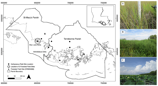
Figure 1. Site location map and vegetation representative in the areas. A) An example of Spartina which is common throughout the wetland. B) An example of the dense cover and heterogeneity of the herbaceous marsh. C) An example of floating vegetation at the study site Source: Thomas et al., 2019
Citation
Castaneda, E., A.I. Christensen, M. Simard, A. Bevington, R. Twilley, and A. Mccall. 2020. Pre-Delta-X: Vegetation Species, Structure, Aboveground Biomass, MRD, LA, USA, 2015. ORNL DAAC, Oak Ridge, Tennessee, USA. https://doi.org/10.3334/ORNLDAAC/1805
Table of Contents
- Dataset Overview
- Data Characteristics
- Application and Derivation
- Quality Assessment
- Data Acquisition, Materials, and Methods
- Data Access
- References
Dataset Overview
This dataset provides vegetation species, height, stem density and diameter, and species aboveground biomass (AGB) measurements collected at herbaceous and forested wetland sites across the Atchafalaya and Terrebonne basins within the Mississippi River Delta (MRD) floodplain in coastal Louisiana, USA. The measurements were made during the Pre-Delta-X campaign in Spring 2015 and Fall 2015. Vegetation height and density and diameter data are only provided for forested Atchafalaya sites during the spring collections. At the nine herbaceous wetland sites, a transect was established perpendicular to the wetland edge with replicate sample plots (0.25 m2, 5 m apart) located at 50, 100, and 150 m from the wetland edge to capture the range of vegetation structure, zonation, and composition. AGB was harvested inside the duplicate plots at each sampling location. At the six forested wetland sites, duplicate circular plots (10 m radius, 50 m apart) were established inside the forest approximately 30 m from the wetland edge. All trees with a diameter at breast height (DBH at 1.3 m) > 2.5 cm were measured within each plot and identified to species. The height of trees was measured with a laser range finder. AGB was estimated using species-specific allometric equations. Measurements were used to generate marsh and forested wetland coverage and biomass in response to seasonality within both basins. The data will be used to calibrate remote sensing data (e.g., UAVSAR, AVIRIS-NG) and hydrodynamics and sediment transport models.
Pre-Delta-X was a joint airborne and field campaign in the MRD beginning Spring 2015 and continuing through Fall 2016. The Pre-Delta-X campaign conducted airborne (remote sensing) observations and field (in situ) measurements to characterize delta hydrology, water quality (e.g., total suspended solids), and vegetation structure. These data facilitate the continued development of sampling methods, algorithms, and models to support the upcoming airborne and field campaigns (2021–2023) in support of the Delta-X mission.
Project: Delta-X
The Delta-X mission is a NASA Earth Venture Suborbital-3 mission to study the Mississippi River Delta in the United States, which is growing and sinking in different areas. River deltas and their wetlands are drowning as a result of sea level rise and reduced sediment inputs. The Delta-X mission will determine which parts will survive and continue to grow, and which parts will be lost. Delta-X begins with airborne and in situ data acquisition and carries through data analysis, model integration, and validation to predict the extent and spatial patterns of future deltaic land loss or gain.
Related Publications
Thomas, N., M. Simard, E. Castañeda-Moya, K. Byrd, L. Windham-Myers, A. Bevington, and R.R. Twilley. 2019. High-resolution mapping of biomass and distribution of marsh and forested wetlands in southeastern coastal Louisiana. International Journal of Applied Earth Observation and Geoinformation, 80:257–267. https://doi.org/10.1016/j.jag.2019.03.013
Jensen, Daniel, Kyle C. Cavanaugh, Marc Simard, Gregory S. Okin, Edward Castañeda-Moya, Annabeth McCall, and Robert R. Twilley. 2019. “Integrating Imaging Spectrometer and Synthetic Aperture Radar Data for Estimating Wetland Vegetation Aboveground Biomass in Coastal Louisiana.” Remote Sensing 11 (21): 2533. https://doi.org/10.3390/rs11212533
Related Datasets
Additional Pre-Delta-X datasets are available on the ORNL DAAC Delta-X project page.
Acknowledgments
This work was supported by the Delta-X mission (funded under the NASA Earth Venture Suborbital-3 program), Caltech/JPL President Director's Fund FY14, JPL's Research and Technology Development (R&TD) FY15 and FY16, and JPL's Strategic R&TD FY17-19.
Data Characteristics
Spatial Coverage: Atchafalaya and Terrebonne Basins, Mississippi River Delta (MRD) floodplain, southern coast of Louisiana, USA
Spatial Resolution: Points
Temporal Coverage: 2015-05-06 to 2015-09-28
Temporal Resolution: One-time measurement
Site Boundaries: Latitude and longitude are given in decimal degrees.
| Site | Westernmost Longitude | Easternmost Longitude | Northernmost Latitude | Southernmost Latitude |
|---|---|---|---|---|
| Atchafalaya and Terrebonne Basins | -91.45908 | -90.72775 | 29.53949 | 29.24706 |
Data File Information
There are two data files in comma-separated value (.csv) format. The files are named PreDeltaX_VegetationSummary_Fall2015.csv and PreDeltaX_VegetationSummary_Spring2015.csv. The two files differ in that variables related to vegetation structure were collected in Spring 2015, but not in Fall 2015.
User Note: An observation is defined by the variables site_id, plot_distance_from_shore, plot_replicate, and species. A user can average AGB as desired.
Table 1. Variable names and descriptions. Missing values are indicated by -9999 or NA.
| Variable | Units | Description |
|---|---|---|
| basin | Atchafalaya or Terrebonne | |
| campaign | Spring 2015 or Fall 2015 | |
| date | YYYY-MM-DD | Date of sampling |
| site_id | Site name; sites labeled with "CRMS" are part of the Coastal Reference Monitoring System (CRMS, Steyer et al., 2003); sites beginning with "T" are forested sites; they are large plots where multiple trees were measured, and allometric equations were used to estimate biomass | |
| plot_distance_from_shore | m | Plot distance from shore (intended approximate distance) 50, 100, or 150 m |
| plot_replicate | A or B, designated duplicate plots | |
| latitude | decimal degrees | Latitude of site |
| longitude | decimal degrees | Longitude of site |
| species | Name of vegetation | |
| agb | g/m2 | Dry mass of individual species aboveground biomass per unit area. At the herbaceous sites, AGB was harvested inside duplicate plots. At the forested sites, AGB was estimated within plots using individual tree measurements and allometric equations. |
| aboveground_height | cm | Height of plants within a plot; provided for forested sites for Spring 2015 only |
| aboveground_density | stems/m2 | Number of plant stems per unit area; provided for forested sites for Spring 2015 only |
| aboveground_diameter | cm | Diameter of plant stems within a plot; provided for forested sites for Spring 2015 only |
Application and Derivation
Vegetation structure and AGB estimates will be used to calibrate remote sensing data (e.g., UAVSAR, AVRIS-NG) and hydrodynamics and sediment transport models. The models will quantify the mesoscale (i.e., on the order of 1 ha) patterns of soil accretion that control land loss and gain and predict the resilience of deltaic floodplains under projected relative sea-level rise.
Understanding and mitigating the impact of the relative sea-level rise on coastal deltas is urgent. If ignored, relative sea-level rise will very soon have devastating consequences on the livelihood of the half-billion people that live in these low-lying coastal regions (Thomas et al., 2019).
Quality Assessment
At the herbaceous wetland sites, samples were collected from two replicate plots (A and B; area = 0.25 m2).
Data Acquisition, Materials, and Methods
Study Area
The study area was the Atchafalaya and Terrebonne Basins on the southern coast of Louisiana within the Mississippi River Delta (MRD) floodplain (Figure 2). The Mississippi Delta formed as a series of overlapping lobes over the past 6000–7000 years and consists of two physiographic units, the Deltaic plain to the east and Chenier plain to the west. The deltaic plain contains the Atchafalaya River, a major distributary of the Mississippi River that dominates the study site and which terminates at the Wax Lake and Atchafalaya Deltas (Roberts, 1997). These deltas receive water and sediment discharge from the Atchafalaya River, which is maintained at 30% of the combined discharge of the Mississippi and Red Rivers. April is considered the early phase of the vegetation growing season and the peak of the spring river flood season. Several of the selected sites for field measurements are part of the Coastal Reference Monitoring System (CRMS, Steyer et al. 2003).
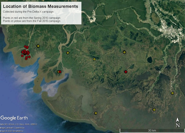
Figure 2. Location of biomass measurement sites. The red circles show field measurements collected in Spring 2015. The yellow circles show field measurements collected in Fall 2015.
Sampling and Analyses
At the herbaceous wetland sites, a transect was established perpendicular to the wetland edge. AGB was harvested inside duplicate plots (0.25 m2, 5 m apart) established at 50, 100, and 150 m from the wetland edge to capture a range of hydrogeomorphic zones and characterize vegetation structure, zonation, and composition. Distance from shore varied with site depending on accessibility. All aboveground plant material within each plot was clipped at their base, stored in plastic bags, refrigerated inside a cooler at 4ºC, and transported to the laboratory. Fresh plant material was initially sorted by species and subsequently dried for 72 h at 60 ºC and weighed to obtain biomass. AGB was expressed in g/m2 (Thomas et al., 2019).
At the forested wetland sites (Spring 2015 collections), duplicate circular plots (10 m radius; 50 m apart) were established inside the forest approximately 30 m from the edge. All trees with a diameter at breast height (DBH ar 1.3 m) > 2.5 cm were measured within each plot and identified to species. The dominant species were willow trees with lesser occurrences of bald cypress and maple trees (Thomas et al., 2019). The height of all trees was measured with a laser range finder (Impulse 200 LR, Laser Technology Inc., Tucson, WY). Published species-specific allometric equations were used to estimate AGB using Chojnacky et al. (2013) for willow trees and Jenkins et al. (2003, 2004) for bald cypress and maple species.
Data Access
These data are available through the Oak Ridge National Laboratory (ORNL) Distributed Active Archive Center (DAAC).
Pre-Delta-X: Vegetation Species, Structure, Aboveground Biomass, MRD, LA, USA, 2015
Contact for Data Center Access Information:
- E-mail: uso@daac.ornl.gov
- Telephone: +1 (865) 241-3952
References
Chojnacky, D.C., L.S. Heath, and J.C. Jenkins. 2013. Updated generalized biomass equations for North American tree species. Forestry, 87(1):129–151. https://doi.org/10.1093/forestry/cpt053
Jenkins, J.C., D.C. Chojnacky, L.S. Heath, and R.A. Birdsey. 2003. National-scale biomass estimators for United States tree species. Forest Science, 49(1):12–35. https://doi.org/10.1093/forestscience/49.1.12
Jenkins, J.C., D.C. Chojnacky, L.S. Heath, and R.A. Birdsey. 2004. Comprehensive database of diameter-based biomass regressions for North American tree species. General Technical Report NE-319. US Department of Agriculture, ForestService, Northeastern Research Station, Newtown Square, PA, pp. 45. https://doi.org/10.2737/NE-GTR-319
Roberts, H.H. 1997. Dynamic changes of the Holocene Mississippi River delta plain: The delta cycle. Journal of Coastal Research, 605–627. https://www.jstor.org/stable/4298659
Steyer, G.D., C.E. Sasser, J.M. Visser, E.M. Swenson, J.A. Nyman, and R.C. Raynie. 2003. A proposed coast-wide reference monitoring system for evaluating wetland restoration trajectories in Louisiana. Environmental Monitoring and Assessment, 81(1/3):107–117. https://doi.org/10.1023/A:1021368722681
Thomas, N., M. Simard, E. Castañeda-Moya, K. Byrd, L. Windham-Myers, A. Bevington, and R.R. Twilley. 2019. High-resolution mapping of biomass and distribution of marsh and forested wetlands in southeastern coastal Louisiana. International Journal of Applied Earth Observation and Geoinformation, 80:257–267. https://doi.org/10.1016/j.jag.2019.03.013